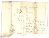
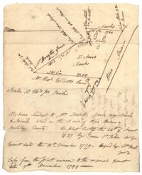
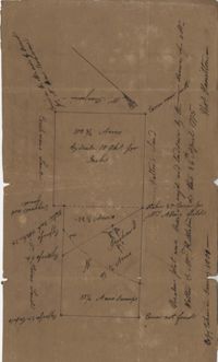
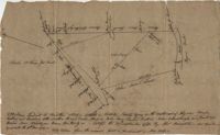
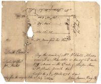
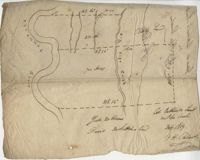
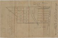
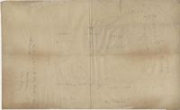
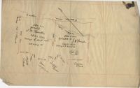
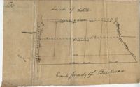
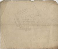
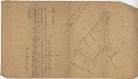
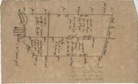
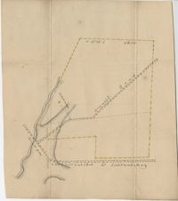
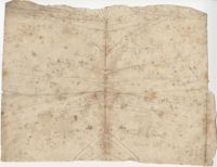
Tract of land on Pawley's Island containing 10 acres situated to the south west of Hasell, known as Lot No.6. Names associated with this plat are Colonel P. Fraser, Hasell, Goudin, Robert Campbell, Anderson, Hoben [?], Joseph Port-Geaur, Thomas Bouhia [?], May Smith, H. Eclert [?], D. Wary, W. Snipes, Mazyck, Mitchell and Grant. Notable geographic locations include Pawley's Island, Georgetown District and Sash Creek.
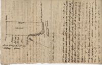
Copy of a plat of annexed to the original grant to John Stanyarn for 300 acres on Wadmalaw Island now belonging to Barnet Adams. Names associated with this plat include Barnet Adams, Edmund Bellinger, John Stanyarn, William Green, Joseph Tobias, Christopher Williamson, John Mill and Winborne Laughton. Notable geographic locations include Wadmalaw Island and Bohicket Creek.
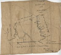
Copy of a plat of 355 Acres of land in Berkeley County near the West side of Cooper River, shows surrounding properties, doesn’t include land type or detailed notations. Names associated with this plat are Edward Keating, William Kimlough, Buvet, Matthew Beard, Colonel Chicken, Chapennoun Elliott, Robert Daniell, Longrove Thomas, Edward Keyting, Andrew Allens, William Gibbons, James Kenloch, William Adams, Allen Anderson, William Gibbons, Matthew Benson, Thomas Smith, John Vecandge [?], Francis Ternandol, and Allen Andrew. Notable geographic locations include St. James Parish, Goose Creek, Cooper River, and Berkeley County.
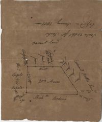
Copy of a plat of 200 acres in St. George’s Parish. The property lines and various trees located on them are the only details included. Names associated with this plat are G. Wagner, Samuel Jones, Thomas Hotkins, Francis Yonge, and Robert Daniell. Notable geographic locations include the Stono River and Berkeley County.
Plat of 57 acres belonging to Dorothy Jones on the Stono River. At the time of the copy belonged to George Wagner. Names associated with this plat are Dorothy Jones, George Wagner, Bull and John St. James.
Plat of land annexed to a release from Benjamin Elliott to William Brandford for 362.5 acres. At the time of the copy belonged to George Wagner. Names associated with this plat include William Branford, Benjamin Elliott, Wagner George and Thomas Elliott.
Copy of a plat of 200 acres in St. George’s Parish. The property lines and various trees located on them are the only details included. Names associated with this plat are Benjamin Cattell, Richard Bedon, and Edward North. Notable geographic locations are St. George's Parish and Cypress.
Plat consists of 100 3/4 acres. Names associated with this plat include William Walter, William Kittlebum, Coachman, Thomas Hamilton, Benjamin, Richard and Allen. Notable geographic locations include St. George Parish and Cypress.
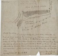
A 550 acre plot of land given to Francis Middleton, the entire plot is labeled as marsh located on the banks of the branches of the Santee River. Names associated with this plat are Francis Middleton, Ephraim Mitchell, Josh Purcell and A. Darby. Notable geographic locations included are St. James Parish.
Copy of a plan annexed to a deed for 177 acres given by Ebenezer Simmons to the John's Island Society lying adjoining the church on Johns Island. Names associated with this plat are Johns Island Society, Ebenezer Simmons, James Lawson, Robert Gibbes, William Boone, John Freer, George Scott, Thomas Smith, Daniel Doyley, Joshua Ward, John Hanyon, John Moultrie, Isaac Wraught, and John Stanyarn.
Plat of land on Goose Creek belonging to Dr. Charles Drayton. Details include an area of marsh and the location of Goose Creek. Names associated with this plat are Dr. Charles Drayton, Michau, Manigault and Richards.
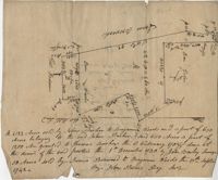
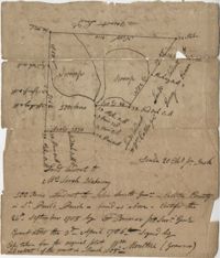
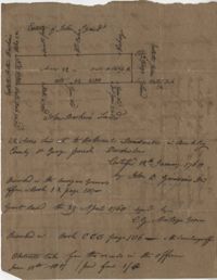
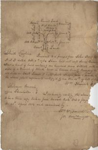
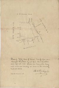
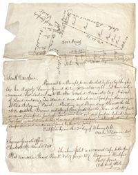
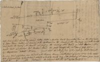
"In the above delineated plat A represents a tract of land containing 120 acres originally granted to William Sanders the 10 May 1734 for 100 acres, now held by William Allen Milis B containing 134 acres is part of a tract granted to Roger Simner the 21st day of April 1733 for 4200 acres and now held by William Edward Perry - Situated on the Cypress Swamp in St. George’s Parish Berkeley County and… a fore said and butting and bounding and having such marks and shape as are about set the Certified the 23rd July 1775 by John Fenwick Copy taken from the original in July 1801." Names associated with this plat are William Allen Milis, Roger Simner, William Edward Perry, William Benjamin Coachman, William John Glaize, Daniel Blake, William H. Drayton, Watter, Sanders, and John Fenwick. Notable geographic locations include St. George's Parish, Cypress Swamp, and Bedons.
200 acres laid out to Jonathan Stocks situated in Colleton County lying on the side of Kywa [Kiawah] Creek, shows surrounding properties with no land type or detail. Names associated with this plat are Jonathan Stock, John Jones, John Edenborough, Thomas Jones, and Thomas Weatherby.
Plat of 230 acres on Johns Island. Little detail included on the plat, but there is an short explanation of the deed. Names associated with this plat are John Jones, Ebenezer Simmons, James Witter, Samuel Palmevine, John Palmavin, and Welkins. Notable geographic locations included in this plat are the Keiwaugh [Kiawah] River, Coll’s Creek, Savannah Tract, Johns Island, and Colleton County.
"Release from Thomas Osborn a Sheriff Charleston District to Philip Hart dated 6 October 1794 for a tract of land measuring and Containing 500 acres more or less situated lying and being on the Cypress Swamp in the district of Charleston Butting and Bounding Westwardly on land now or late the property of David Manll. Southwardly on lands of John Conard, Eastwardly on lands of Thomas Waring and Northeastwardly on lands belonging to Major James Postell - Sold under [?] in the property of William Doweth." Names associated with this plat are Thomas Osborn, William Dewitt, Hart, David Manll, John Conrad, Thomas Waring, Philip Hart, James Postell, and William Doweth. Notable geographic locations include St. George Parish, Cypress Swamp and Charleston District.
Plat of 380 acres on a great swamp near Coll. Pen Bay. Names associated with this plat are John Jones, Joseph Haynes, Lewis Oglesbee, M. Cattersloni [?], and John Rofe.
179 acre plot of land given to Mr. Webster, shows the property lines and no land type detail. Names associated with this plat include Webster, Peters, Branford, and John James Haig. Notable geographic locations include the Pon Pon River.
"Jonathan Burnbridge 310 acres certified for him the 24th day of December 1805. Pursuant to a warrant from Artemar B. Darby D. S. G. dated the 20th day of December 1805 having admeasured and laid out unto Jonathan Bunbridge a tract of land containing 310 acres situated in Charleston District bounded by a lain [sic] running NW and NW by land of Ralph Izard NE on land of William Stephens NE and E on land not known and by all other lines on land of Doctor William Stephens and hath such form and marks as the above plat represents Surveyed the 21 day of December 1805 Michael Byrne Dep Surveyor." Names associated with this plat are Jonathan Darby Bunbridge, B. Artemar, Ralph Izard, William Stepens, Dr. William Stephens, and Michael Byrne. Notable geographic locations include St. Bartholomew’s Parish.
Plat of 419 acres near Goose Creek sold to Benjamin Wood by John Parker. Only the trees located on the property line and names on neighboring property owners are included. Names associated with this plat are John Parker, Benjamin Wood, Thomas Barker, John Barley, James Boswood, Benjamin Woods, John Stevens, Thomas Hodson, I. Drayton, Thomas Mell, and Ben Godin.
Copy of a plat of 500 acres originally laid out to John Smith, now (1805) belonging to Alexander Bower as nephew and heir to the grantee. Details include swamps, surrounding lands, and trees. Names associated with this plat are Alexander Bower, John Smith, F. Bremar, William Moultrie, Sarah Blakeway, William Cattle, and Henry Crum.
Plat of Hopewell Plantation with surrounding lands owned by several people, shows the Edisto River and an unnamed settlement, labels the land in the center as uncleared land while swamps, roads, rivers and trees surround it. Acreage unclear. Names associated with this plat are Baring, Branford, Mellechamp, Colonel W. Hayne and Arthur Middleton. Notable geographic locations are St. Paul's Parish, Edisto River, and Willtown Road.
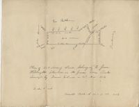
Plat of 1,000 acres on Strawberry Bay granted to James Packer. The bay and marsh area is marked but there is little other detail included. Names associated with this plat include James Packer, William Sparkmon, James G. Ware, and W. Moultrie.
Copy of a plat of 200 acres on the neck of the Ashley River belonging to Thomas Butler. Only property outline and a few notes about the edges of the property are included. Names associated with this plat are Thomas Butler, Barker, John Bradford, and John Archdale. Notable geographic locations include the Ashley River, Clear Spring and St. Andrew's Parish.
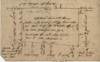
Plat of 42 acres in St. George’s Parish belonging to Nathaniel Bradwell. Very little detail included with the plat. Names associated with this plat include Nathaniel Bradwell, John B. Giradeau, E.G. Montagu, John Barker, and Peter Haskins.
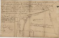
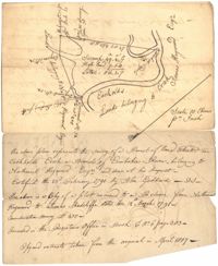
56 acre plot of land given to Radcliffe, the plot of land is bordering Cuckolds Creek, shows surrounding property owners, no land type detail or identification. Names associated with this plat are Thomas Radcliffe, Nathaniel Heyward, John Goddard and James Heyward. Notable geographic locations include Cuckolds Creek, Combahee River and St. Bartholomew's Parish.
General Cutherbert's land on Big Pipe Creek. Names associated with this plat are General Cuthbert, B.H. Roberts, Ball, Peters and David DeSapah [?]. Notable geographic locations include the Savannah River.
Copy of a plat of a tract of land containing 100 acres situated on the west side of branch of Black River in Craven County bounding on all sides on vacant land. Names associated with this plat are John Trough, James Bauman, Robert McDaniel, Gluscork [?], Howard, and Samuel Bunger. Geographic locations include Craven County [now in parts of Berkeley, Charleston, Georgetown, and Williamsburg counties], Black River, and Blues River.
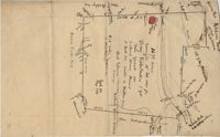
Copy of a plan of lots No.1-7, 9-11 on Cumberland Street in Charleston, Ward No.3. Indicates some buildings including a brick stable at No. 9 and DeBorr’s house and lot. “Lands of Mr. Edwards" is written above the lots. Names associated with this plat include De Borr, Edwards, and Charles Parker. Notable geographic locations include Church Street, Corr Alley or Philadelphia Street, Cumberland Street, and Ward Number 3.
1300 acres surveyed for James Bowman, no land type or detail, shows property boundaries and neighboring plots. Names associated with this plat are James Bowman, Morris, Oswald, Warley, E.B. Fishburn, Lindsey, and B.G.O. Bryan. Notable geographic locations include New road leading to Parkers Ferry [?].
Small description of a 264 acre land, near Wappoo Creek, including land description. Names associated with this plat are John Schnerlie, Thomas S. Jones, and Edwin R. Dorrill. Notable geographic locations include the Ashley River, Wappoo Creek, Ashley Bridge Ferry Road, and Charleston District.
Plat consists of 50 acres titled Newington Plantation bounding on Middleton Plantation. Names associated with this plat include Johnson Middleton, N.W. Ancrum, G.H. Ingraham, R.B. Pinckney and H.A. Middleton.
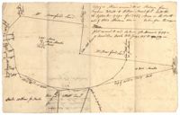
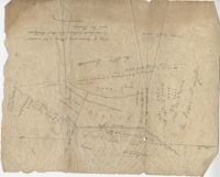
Pencil sketch of a plot of land that includes roads, creeks, and ponds, shows surrounding neighbors and little land detail. Names associated with this plat are Rich Jenkins. Notable geographic locations include Road to Bear Bluff and Wadmalaw River Marsh.
Plat of 1126 acres in St. James Goose Creek on Wasamasaw [Wassamassaw] Swamp. Plat is in pencil and is difficult to read the few details, although there are a few outlines of buildings included, but difficult to tell what they are. Names associated with this plat include Daniel Gelyer, J. Ferrels, Thomas Cusack [?], and James Haney. Notable geographic locations include Wasamasaw [Wassamassaw] Swamp, Sheep Island, Goose Creek, Road to Dorchester, and Ekells Branch.
Plat of 1199 acres in St. Johns Parish. Names associated with this plat are Daniel Gelyer, Peter Sanders, James Rown, Thompson, Meadwell, S. Brichelle [?] and Maun. Notable geographic locations include Berkeley.
Copy of two tracts of land A and B. A containing 1144 acres, and B, containing 580 located north of the Santee River and Duck Creek for Georgetown District. John Hutchinson, Chardon, Laroche, Foijsin, Gail Huger, Isaac Huger, Mark Hugin, Ford, Job. Rothmaklen, Jospeh Purcell and Charles Parker. Notable geographic locations include Mosquito Creek, Four Mile Creek, Belin Creek Duck Creek, Minim Creek, Santee River, Winyaw Bay, and Georgetown District.
Copy of a plat of land containing 200 acres situated near Godfrey Savana in St. Bartholomew’s Parish. Names associated with this plat include Edward Fenwick, Egerton Leigh, John Brown, Hugh Crawford, John McQueen, Owen Bowen and Thomas Jones. Notable geographic locations include Godfrey's Savana [Savannah].
100 square plot sold by Beauford, Boggy Gully runs through the southwest corner of the property. Names associated with this plat are William Byrd Beauford and J.B. Johnson.
Plat of 202 acres in St. James Goose Creek belonging to James Headright. Details include trees on the property line and the names of neighboring property owners. Names associated with this plat are James Headright.
1432 acres of land given to Villeconteux; shows mill creek and Raccoon Pond, one area is colored in red labeled "Gardenes Old Field." Names associated with this plat are Barry Villeconteux, Rich Selby, N. Windham, Rhames, Ben Villeponteaux, Lowe Leviman, W.W. Villeponteaux, J.C. Brinson, Addison, Gaillard, Homes, and Thomas Ashley. Notable geographic locations include St. John's Parish, Raccoon Pond, Mill Creek, School House Branch, Blind Doe Run, and Edge Poing.
200 acre plot of land located in Berkeley County budding and bounding on the NW with the Santee River and Russell's Creek, shows tree types and surrounding swamps. Names associated with this plat are Thomas Haile, William DeBrahms, John Evans and Thomas S. Jones.
Plat of 1,136 acres granted to Thomas W. Markley. Plat includes the Santee River, a lake, and various trees on the property line. Names associated with this plat are Thomas Markly, R.P. Smith and David Owens. Notable geographic locations include Santee River and [Northrace] Lake.
Plat of 19 acres in St. Andrew’s Parish. A corn field is noted as is a public road along with the neighboring property owners. Little other detail. Names associated with this plat are James C. Perry, Cook, Sault, Benjamin, F.R.N. [?] Smith, Dinzhals [?], S. Charles, and Cattell.
Plat of 288 acres of land situated on Wadmalaw Island. Names associated with this plat are William Weston, Jonathan Runnel, James Clarks, Benjamin Allston [?], and Henry Treads. Notable geographic locations include Wadmalaw River, Wadmalaw Island, Bain Bluff, and Charleston District.
Two plats of lands along the Savannah River belonging to Stobo and Bullock. Names associated with this plat are Archibald Stobo, James Stobo, James Bullock, W. Hugh Bryan, Clawton [?], Cranford, J. Southerland, and Patrick Mikas. Notable geographic locations include the Savannah River, St. Peter's Parish and Purrysburgh Township.
Plat of 89 acres in the Beaufort District. Plat shows the location of several ponds. Little other detail is included. Names associated with this plat are N.H. Johnson, R.J. Marker, Mary Kittles, John H. Raddell [?], and Brown. Notable geographic locations include the Savannah River, Beaufort District and Dry Gull Branch.
Plat of a tract of land. Very general with little information. Includes a street and placement of an Episcopal church. Names associated with this plat include D. La Roche, W.H. Gray, Steven Jenkins, and J.K. Goudin. Notable geographic locations include Wadmalaw.
Plat of 101.5 acres on Ocketee [Oakatie] Creek. Plat shows the location of a marsh, road and surrounding lands. Names associated with this plat are N.H. Johnson, Ellis and Hogg. Notable geographic locations include the Savannah River, Oakatie Creek and Ellis Road.
Plat of a land containing ten acres, minimal detail showing the surrounding property owners and two roads; Dills Bluff and unnamed public road. Names associated with this plat are Plenty White, Simons and Howe. Notable geographic locations include Dill's Bluff.
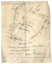
Plan of land in St. James Santee for Abraham Micheau. Names associated with this plat are Ann Colburn, Gardner, Anthony Germain, Buneli, B. Skipper, Isaac Skipper, Abraham Micheau, and William H. Simons.
319 acre plot of land situated on Ocean Bay in St. James Parish, part of the "Hodge Grant," shows some land details like creeks and cypress ponds. Names associated with this plat are T. Hataway, Hodge, W.B. Guerard, Benjamin Fort, B.P. Colburn, Hiram Hodge , R.J. Morrison and W.H. Mellard. Notable geographic locations include Ocean Bay, St. James Parish and Santee.
25 acres of land containing two dams, a reserve, and pine and oak trees owned by George Holmes near 7 mile south of lands owned by J. Meetze. Names associated with this plat include George Holmes, J. Meetze and Simons.
Lands of Paul Guerard called “The Hut," shows a public road and creeks, includes measurements. Names associated with this plat are Parker, W.B. Guerard, William Blacklock, Micah Jenkins, Thomas Humscoube, and Paul C. Grimball.
Plat contains 59 (1/2) acres. Plat contains the road to Ladson running west to east through the property the plat also includes the location of the house as well as the brickyard. Names associated with this plat include E.J. Jackson, M. Brailsford, Caines, Edon, F.C. Shutty and W.B. Guerard. Notable geographic locations include St. James Parish and Goose Creek.
Office copy of a survey of 31 acres of land for Dr. R. H. Martin in Berkeley County. Notable geographic locations include Wappoo Road and Mill Tract. Names associated with this plat are R.H. Martin, G.G. DuPont, and W.B. Guerard.
Plan of approximately 1500 acres on Black River near Georgetown part now belonging to Kinloch and Gadsden. Names associated with this plat are Gadsden, Kinloch, Alston, Thomas Gadsden, James Lloyd, and Morreau [?] Sarrazin.
Plat contains land on the Santee River; acreage unknown. No structures are included. Names associated with this plat are S.G. Staney, A.M. Rickenbacher, and Fred J. Smith. Notable geographic locations include the Santee River.
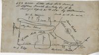
483 acre plot of Little Hell Hole Swamp, includes islands and surrounding property owners doesn't include land detail. Names associated with this plat are H.S. Morrison, Isaac Bishop, W.C. Miller, W.J. Ball, and Anderson. Notable geographic locations include St. Stephens Parish, Hog Pen Island, Little Hell Hole Swamp, and Berkeley County.
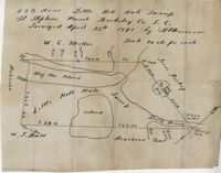
480 acre lot called Little Hell Hole Swamp, includes two islands and surrounding property owners, doesn't include land type. Names associated with this plat are H. Morrison, W.C. Miller, W.J. Ball, Issac Bishop and Anderson. Notable geographic locations include Hog Pen Island, Berkeley County, St. Stephen's Parish, and Little Hell Hole Swamp.
3.71 Acres of highland near marsh adjacent to Meeting Street Road. Names associated with this plat are Karl W. Ruth, A.F.C. Kramer, and S. Louis Simons.
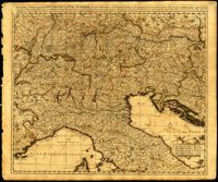
Ornate map of Savoy in the French alps by Joan Blaeu (1596-1673). Map is richly detailed with pictorial relief of mountains and watersheds. Putti hold the coat of arms of the dukes of Savoy above the title cartouche in the lower left corner. Other family crests from the regional duchies and baronies ring the map. First published by Blaeu's heirs after his death in his town book of Savoy and Piedmont (Theatrum Sabaudiae). Map was designed by Giovanni Tommaso Borgonio (1620-1683) and engraved by Johannes de Broen (1649-1730). Amsterdam. 52 x 62cm.
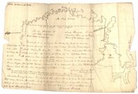
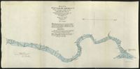
These five maps of the Waccamaw River in Horry County, S.C., show the river from Conway to Bull Creek. The surveys, dated November 1903, were performed under the direction of Captain G. P. Howell, Corps of Engineers U.S.A., and Reid Whitford, U.S. Assistant Engineer. The surveyor was William H. Johnstone.
35 acres granted to John Izard in September of 1766 then sold to William B. Mitchell. Names associated with this plat are John Izard, William B. Mitchell, William Cattle, Isaac W. Mcpherson, James Brisbans, Mep Martha Miles, Samuel Wainwright, Gum Huhy [?], William Sanders. Notable geographic locations include St. Paul's Parish.
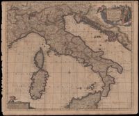
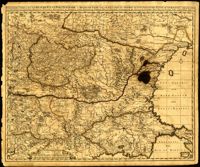
Map of the Italian piedmont by Thomas Blaeu (1596-1673). Similar to Tabula Generalis Sabaudiae by Blaeu and slightly overlapping in coverage. First published by Blaeu's heirs after his death in his town book of Savoy and Piedmont. Map was designed by Giovanni Tommaso Borgonio (1620-1683) and engraved by Johannes de Broen (1649-1730). Amsterdam. 52 x 62cm.
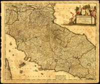
Map of central Italy by Frederick de Wit (1630-1706) showing the grand duchy of Tuscany and the papal states. Title cartouche is decorated with the ball-motif shield of the Medici family; the papal states are represented by the Keys of St. Peter on a shield. Detail on the map includes a road that extends from Rimina on the Gulf of Venetia to Piacenza in the northeast. Amsterdam. 52 x 62cm.
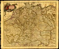
Map of central Europe by Justus Danckerts (1635-1701). Map extends from France in the west to Poland in the east and from Croatia and Italy in the south to the Netherlands in the north. The Hapsburg eagle holds the title banner in the upper left cartouche. Amsterdam. 52 x 62cm.
One of three maps by Nicolaes Visscher (1649-1702) collectively showing the entire length of the Danube. This map depicts the upper Danube from its start in Germany to Bratislava (Presburg on map). Amsterdam. 52 x 62cm.
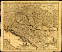
One of three maps by Nicolaes Visscher (1649-1702) collectively showing the entire length of the Danube. This map covers the middle part of the river from Linz through Vienna, Bratislava and Budapest, to just east of Belgrade. Amsterdam. 52 x 62cm.
One of three maps by Nicolaes Visscher (1649-1702) collectively showing the entire length of the Danube. This map depicts the lower Danube from Belgrade to its mouth in the Black Sea. Amsterdam. 52 x 62cm.
Map by Justus Danckerts (1635-1701) covers the Danube River from Germany to the Black Sea. Depicts all of the Balkans, Hungary, Romania and parts of Austria, Italy and Germany. The map was apparently printed at the height of the Ottoman wars against the European powers in the late seventeenth century. A table in the lower left depicts the names of cities in the Hungarian kingdom that were lost to the Ottomans and when they were recovered to date. The latest date on the table is 1687. However, according to the table, the recapture of Buda (Budapest) took place in 1686 but an examination of Buda on the map reveals a date of 1688. Other known examples of this map include the recovery of Belgrade (Belgrado) in 1688 in the table although this version of the map does not. It is possible this map was printed immediately before the Siege of Belgrade in 1688 or after 1690 when the city was reclaimed by the Turks (and the subsequent reference to Belgrado in the table may have been expunged). Title cartouche depicts a Christian saint and the Hapsburg eagle. Amsterdam. 52 x 62cm.
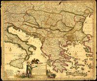
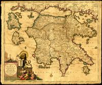
Map of the Peloponnese in southern Greece by Justus Danckerts (1635-1701). Written next to many cities on the map (Athens, Corinth) are the dates they were recovered by the Venetians from Ottoman control. Latest date found on map is 1687. Title cartouche depicts the Venetian lion towering over Turkish soldiers. Amsterdam. 52 x 62cm.
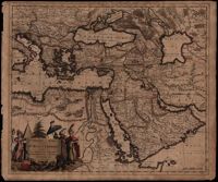
A map of Turkish possessions including Egypt and Greece by Justus Danckerts (1635-1701) shows the Arabian peninsula in the center. A decorative cartouche adorned with several costumed figures, a pyramid, and lions. Amsterdam. 52 x 62cm.
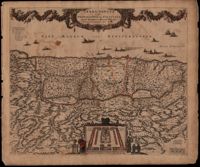
This map was engraved by Frederick de Wit (1630-1706), one of the most prominent and successful publishers in Amsterdam. The Holy Land extends from Sidon and Damascus to the Wilderness of Pharan in the Sinai. The decoration in the map relates to the Old Testament. At the bottom of the map is a depiction of an encampment of the Israelites during Exodus. The Twelve Tribes are around the perimeter and in the center the Tabernacle is illustrated with the Levites in attendance. Moses is at the left holding his staff and his brother Aaron is opposite. The caption in the sea refers to Lebanese cedars being sent by King Hiram of Tyre to King Solomon. The theme of the richness of the Promised Land is emphasized with the beautiful garland supported by the angels across the top, containing fruit, grapes and flowers. North oriented to the right. Amsterdam. 52 x 62cm.
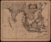
This map was engraved by Johannes L'Huilier and corrected by Frederick de Wit (1630-1706). The map encompasses the regions from India to Southern China, Taiwan, the Philippines, the East Indies and Indonesia with parts of northwest Australia identified as Hollandia Nova. Many islands with their ports are shown. The title cartouche at the top right is surrounded by turbaned warriors and native figures. 52 x 62cm.
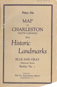
Map of the Charleston peninsula featuring points of interest. Cover title: Map of Charleston, South Carolina with historic landmarks. Blue and gray historical series, booklet no. 1. Published by Wil-Tuc Advertising Agency. Map measures 21” x 6.25” folded to create 13 pages measuring 6.25” x 3.5.
Copy of a plat part now belonging to Benjamin Perry and part to John Pringle on the west side of Ashley River. Names associated with this plat include John Pringle, Benjamin Perry, John Julius Pringle, Lambert Lance, Abraham Ladson, Sarah Rose, Nathaniel Bradwell, Ephraim Mitchell, Thomas Drayton, John Frazer, Frances Baker, Thomas Osborn, Isaac Landson, Isaac Perry, John Drayton, Glen Drayton, Francis Ladson and W. John Cattle. Notable geographic locations include the Ashley River, Charleston, Berkeley County, and Ashley River Road.
Six maps conveying plans to beautify Ansonborough, showing the footprints of buildings and annotated to indicate the status of buildings, traffic flow, and scenarios that would result from the Ansonborough Rehabilitation Project.
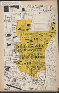
Hand-drawn and color-coded map of Ansonborough indicating properties purchased by HCF, restored by HCF, for sale by HCF, restored privately, and other distinctive antebellum houses. Created to illustrate HCF’s Ansonborough Rehabilitation Project.
Map of Ansonborough showing Meeting Street, King Street, Hasell Street, Maiden Street, Old Church Street, Bay Street, and others. A small piece of paper taped to the back reads: "Kindness of: Mr. Gedney M. Howe."
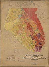
Hand-colored, linen map showing proposed height and area districts for the city of Charleston. Map shows eight height and area districts from Murray Boulevard to the northern limits of the city at Mount Pleasant Road. Map measures 42" by 60".
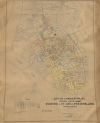
Hand-colored, linen map showing Charleston peninsula existing lot area per dwelling from Murray Boulevard to the northern limits of the city at Mount Pleasant Road. The maps shows lots less than 1,000 square feet; lots more than 1,000 square feet and less than 1,500 square feet; lots more than 1,500 square feet and less than 2,500 square feet; lots more than 2,500 square feet and less than 3,000 square feet; lots more than 3,000 square feet and less than 4,500 square feet; and lots greater than 4,500 square feet. Map measure 47" by 63".
Plat of land near Pocotaligo. Very little information and explanation are included. The land looks to be near a crossroads and some form of water. Names associated with this plat are Cuthbert. Notable geographic locations include Augusta Road, Cossawhatchie [Coosawatchie], Pocotaligo, and Prince William's Parish.
Plat is laid out for 200 acres of land but when surveyor toured the land contained 547 acres apparently the surveyor did not "run the lines" properly when the land was first laid out and not setting corners. Names associated with this plat are Thomas Tucker, Archibald Crall, John Cook, Richard Ireland, Levey, John Linder, and James Stuard. Notable geographic locations include the Edisto River.
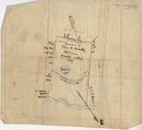
Plan of Belle Island north of Four Mile Creek consisting of 316 acres. Names associated with this plat are Middleton, Richard Lowndes, and W.R. Maxwell. Notable geographic locations include Belle Isle, Four Mile Creek, and Manquils Creek.
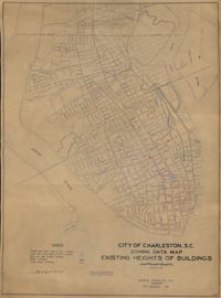
Hand-colored, linen map showing Charleston peninsula heights of buildings from Murray Boulevard to the northern limits of the city at Mount Pleasant Road. Height in stories is indicated by color coding. Map shows buildings of three stories or more. Map measures 42" by 60".
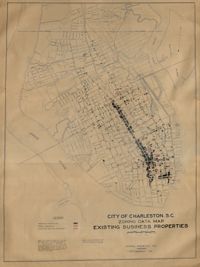
Hand-colored, linen map showing Charleston peninsula existing business properties, public garages, and gasoline service stations from Murray Boulevard to the northern limits of the city at Mount Pleasant Road. Map measures 46.75" by 63".
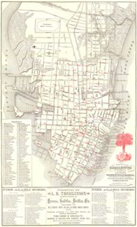
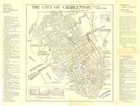
Map of the Charleston peninsula. Revised in 1879; published by Walker, Evans & Cogswell. Features locations of fire alarm boxes and public buildings, with indexes to each. Presented by A.R. Thomlinson, manufacturer of harness, saddles, bridles, etc., located at 137 Meeting Street. Measures 21.875" x 13.625"
Map of the Charleston peninsula with historic points of interest identified and noted. Includes a welcome to visitors by Mayor Burnet R. Maybank and a map of "The Garden Club Walk" route. "Released by the Office of Port Development." Measures 16" x 22".
Plat of land with rice fields and highlands noted along with the neighboring properties. Very little other detail or explanation given. Names associated with this plat include Carson, Isaac Waight, and Ann Stanyarn.
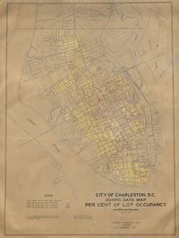
Hand-colored, linen map showing Charleston peninsula lot occupancy from Murray Boulevard to the northern limits of the city at Mount Pleasant Road. Map is color coded to show lot occupancy percentages on the peninsula. Map measures 46.5" x 63".
Farm of 54 across for sale by Rutherford, individual plots lettered A-S. Names associated with this plat are Birkman, Rutledge Phokes, Fitch, Kinsman and Rutherford. Notable geographic locations include Broad Street and Dorchester Road.
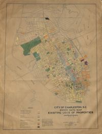
Hand-colored, linen map showing Charleston peninsula existing lot uses from Murray Boulevard to the northern limits of the city at Mount Pleasant Road. Map shows one, two, and multiple dwelling units, service stations, garages, industrial sites, and railroads. Information on map was compiled during field observations made from October through December 1930. Map measures 46.25" by 63."
Linen map showing distribution of schools in Charleston from Murray Boulevard to the northern limits of the city at Mount Pleasant Road. Map shows school district lines, developed and undeveloped school properties and racial population disbursement indicated by white circles for white residents and black circles for black residents. Map is found on page 11 of the Report of the City Planning and Zoning Commission. Map measures 41.25" by 59".