Search Home
Search in
search for
Simple Search
Page Content Search
Title Search
Creator Search
Subject Search
Search
search icon
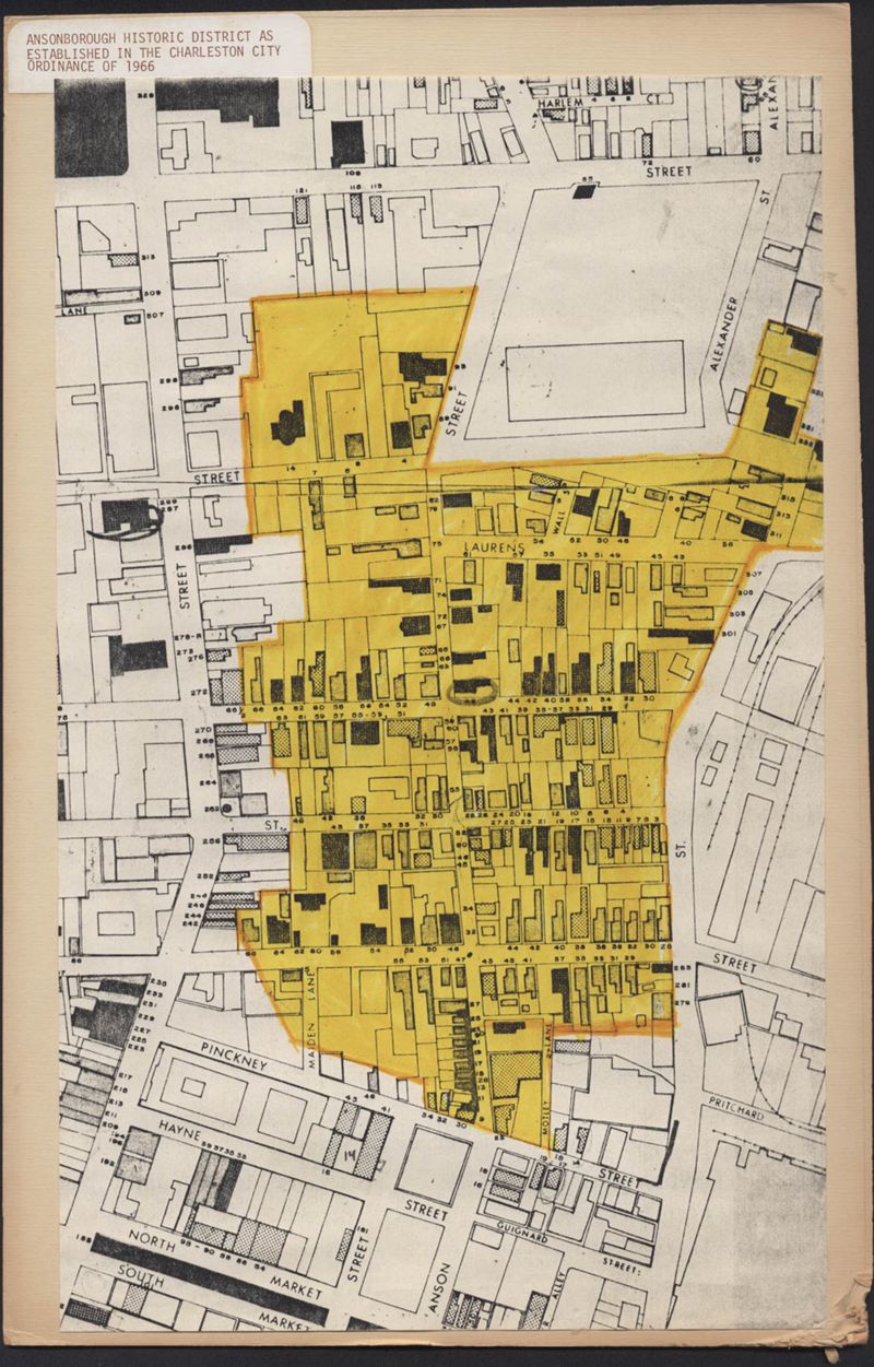
Ansonborough Historic District As Established in the Charleston City Ordinance of 1966
Close Viewer
Title:
Ansonborough Historic District As Established in the Charleston City Ordinance of 1966
Description:
A map of the Ansonborough Historic District. The boundaries of the 1966 Charleston City Ordinance are indicated in yellow.
Collection Title:
Ansonborough Rehabilitation Project
Contributing Institution:
Historic Charleston Foundation
Media Type:
Maps
Series:
Folder 17: Maps of District
Personal or Corporate Subject:
Historic Charleston Foundation (Charleston, S.C.)
Topical Subject:
Neighborhoods--Conservation and restoration--South Carolina--Charleston
and
Historic buildings--Conservation and restoration--South Carolina--Charleston
Geographic Subject:
Charleston (S.C.)--History
S.C. County:
Charleston County (S.C)
Language:
English
Shelving Locator:
HCF.005.3A
Date Digital:
2014-10-17
Digitization Specifications:
600 dpi, 24-bit depth, color, DLSG Bookedge Scanner, Archival masters are tiffs.
Internet Media Type:
image/jpeg
Copyright Status Statement:
Copyright © Historic Charleston Foundation.
Access Statement:
All rights reserved.
Access Information:
For more information and reuse requirements contact Archivist, Historic Charleston Foundation, P.O. Box 1120, Charleston, SC 29402.
Admin ID:
44294
Tools
Email
Cite
Permalink
Permalink
×
https://lcdl.library.cofc.edu/lcdl/catalog/lcdl:93663
Copy Permalink
Share
More Like This
Preservation Progress, Vol. VI, No. 1
Preservation Progress, Vol. II, No. 4
Preservation Progress, Vol. V, No. 1
Letter from S. Henry Edmunds to Ben Scott Whaley, May 6, 1959
Ansonborough Neighborhood Tour