31. Tabula Indiae Orientalis
Close Viewer
- Title:
- 31. Tabula Indiae Orientalis
- Date:
- 1662
- Creator (Personal):
- Wit, Frederick de, 1630-1706
- Contributor:
- L'huilier, Jean (engraver)
- Description:
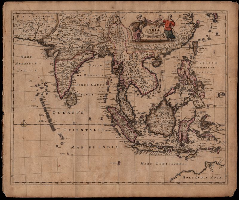
- This map was engraved by Johannes L'Huilier and corrected by Frederick de Wit (1630-1706). The map encompasses the regions from India to Southern China, Taiwan, the Philippines, the East Indies and Indonesia with parts of northwest Australia identified as Hollandia Nova. Many islands with their ports are shown. The title cartouche at the top right is surrounded by turbaned warriors and native figures. 52 x 62cm.
- Collection Title:
- Mitchell King Atlas, 1662-1695
- Contributing Institution:
- College of Charleston Libraries
- Media Type:
- Maps
- Topical Subject:
- Atlases and History, Modern -- 17th century
- Language:
- Latin
- Shelving Locator:
- Mss 0091
- Date Digital:
- 2008-10
- Digitization Specifications:
- 360 ppi, 24-bit depth, color, Epson Expression 10000XL, Archival Master is a tiff. Images merged in Adobe Photoshop.
- Internet Media Type:
- image/jpeg
- Copyright Status Statement:
- Public domain.
- Access Information:
- For more information, contact Special Collections, College of Charleston Libraries, 66 George Street, Charleston SC 29424.
- Admin ID:
- 49255
Permalink