U.S. Engineer Maps of the Waccamaw River, 1903

Close Viewer
- Title:
- U.S. Engineer Maps of the Waccamaw River, 1903
- Date:
- 1903
- Creator (Personal):
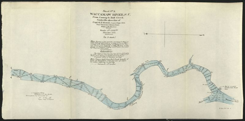
- Howell, G. P. (George Pierce), 1870-1928 and Johnstone, William H., 1867-1936
- Description:
- These five maps of the Waccamaw River in Horry County, S.C., show the river from Conway to Bull Creek. The surveys, dated November 1903, were performed under the direction of Captain G. P. Howell, Corps of Engineers U.S.A., and Reid Whitford, U.S. Assistant Engineer. The surveyor was William H. Johnstone.
- Collection Title:
- U.S. Engineer Maps of the Waccamaw River, 1903
- Contributing Institution:
- Coastal Carolina University, Horry County Archives Center
- Media Type:
- Maps
- Personal or Corporate Subject:
- United States. Army. Corps of Engineers--Maps
- Geographic Subject:
- Conway (S.C.)--Maps and Waccamaw River (N.C. and S.C.)
- S.C. County:
- Horry County (S.C.)
- Language:
- English
- Date Digital:
- 2015-02-19
- Digitization Specifications:
- 400 dpi, 24-bit depth, color, BookEye 4 V1A, Archival masters are tiffs. Scanned by the Lowcountry Digital Library at The College of Charleston.
- Copyright Status Statement:
- Public domain.
- Access Information:
- For more information contact Horry County Archives Center at Coastal Carolina University, Conway, SC 29526.
- Admin ID:
- 24300
Permalink