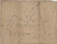
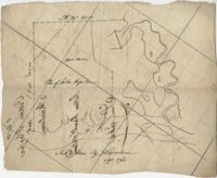
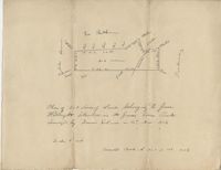
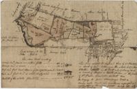
Plat of 42 acres in St. George’s Parish belonging to Nathaniel Bradwell. Very little detail included with the plat. Names associated with this plat include Nathaniel Bradwell, John B. Giradeau, E.G. Montagu, John Barker, and Peter Haskins.
Plat contains 360 acres. Plat includes sketch of house. Names associated with this plat include John Glen, Ephraim Mitchell, Crip, Daniel Cannon, and John Richards. Notable geographic locations include St. James Parish, Goose Creek and Charleston District.
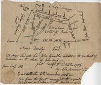
Plat contains 310 acres layer out for John Gamble granted November 6, 1706. Plat contains location of house. Names associated with this plat are John Gamble, Gideon Fishero, Amos Donoly, John Deas, Francis Cobia, Purull, and F. Bremar.
Plat of 1,000 acres on Strawberry Bay granted to James Packer. The bay and marsh area is marked but there is little other detail included. Names associated with this plat include James Packer, William Sparkmon, James G. Ware, and W. Moultrie.
Plat of 163 acres in the St. George District. Very little detail or explanation provided on the plat. Names associated with this plat are David Run, John Woodrich, Elibu [?] Baker, John Drayton, and B. Wood [?]. Notable geographic locations include St. George Parish and St. George District.
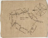
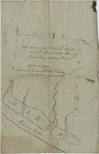
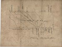
Plat of land with rice fields and highlands noted along with the neighboring properties. Very little other detail or explanation given. Names associated with this plat include Carson, Isaac Waight, and Ann Stanyarn.
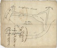
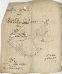
Plan of 500 acres of land along Turtle Island. Notable geographic locations include St. Peters Parish, Turtle Island, Wrights River, Dawfuskie [Daufuskie] Sound, Black Oyster Point, and New River.
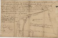
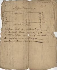
"Release from Thomas Osborn a Sheriff Charleston District to Philip Hart dated 6 October 1794 for a tract of land measuring and Containing 500 acres more or less situated lying and being on the Cypress Swamp in the district of Charleston Butting and Bounding Westwardly on land now or late the property of David Manll. Southwardly on lands of John Conard, Eastwardly on lands of Thomas Waring and Northeastwardly on lands belonging to Major James Postell - Sold under [?] in the property of William Doweth." Names associated with this plat are Thomas Osborn, William Dewitt, Hart, David Manll, John Conrad, Thomas Waring, Philip Hart, James Postell, and William Doweth. Notable geographic locations include St. George Parish, Cypress Swamp and Charleston District.
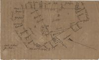
"In the above delineated plat A represents a tract of land containing 120 acres originally granted to William Sanders the 10 May 1734 for 100 acres, now held by William Allen Milis B containing 134 acres is part of a tract granted to Roger Simner the 21st day of April 1733 for 4200 acres and now held by William Edward Perry - Situated on the Cypress Swamp in St. George’s Parish Berkeley County and… a fore said and butting and bounding and having such marks and shape as are about set the Certified the 23rd July 1775 by John Fenwick Copy taken from the original in July 1801." Names associated with this plat are William Allen Milis, Roger Simner, William Edward Perry, William Benjamin Coachman, William John Glaize, Daniel Blake, William H. Drayton, Watter, Sanders, and John Fenwick. Notable geographic locations include St. George's Parish, Cypress Swamp, and Bedons.
Plat of 230 acres on Johns Island. Little detail included on the plat, but there is an short explanation of the deed. Names associated with this plat are John Jones, Ebenezer Simmons, James Witter, Samuel Palmevine, John Palmavin, and Welkins. Notable geographic locations included in this plat are the Keiwaugh [Kiawah] River, Coll’s Creek, Savannah Tract, Johns Island, and Colleton County.
Plan of a parcel of land situated on Johns Island and containing 86 1/2 acres. Being part of a body of land belonging to Thomas Mathews. Bounded northwardly by a public road, eastwardly on James Legare's land, and southwardly on land belonging to Isaac Holmes and Thomas Legare. Intended to be conveyed to Isaac Holmes. Names associated with this plat are Thomas Mathews, Isaac Holmes, Thomas Legare, William Stanyarn, Matthews and James Legare.
Two plats of lands along the Savannah River belonging to Stobo and Bullock. Names associated with this plat are Archibald Stobo, James Stobo, James Bullock, W. Hugh Bryan, Clawton [?], Cranford, J. Southerland, and Patrick Mikas. Notable geographic locations include the Savannah River, St. Peter's Parish and Purrysburgh Township.
222 acres sold by Archibald Stanyarn to Andrew Down in 1772. Reverse side includes notes on various conveyances. Names associated with this plat are Archibald Stanyarn, Andrew Down, J. Williamson, Edmond Bellizer, Thomas Cliffon, Kewn [?], David Joomer [?] and Henry. Notable geographic locations include Colleton County and Stono River.
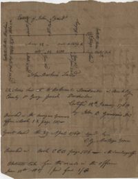
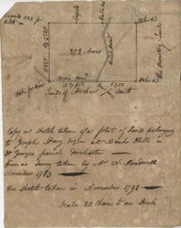
Copy of a plat part now belonging to Benjamin Perry and part to John Pringle on the west side of Ashley River. Names associated with this plat include John Pringle, Benjamin Perry, John Julius Pringle, Lambert Lance, Abraham Ladson, Sarah Rose, Nathaniel Bradwell, Ephraim Mitchell, Thomas Drayton, John Frazer, Frances Baker, Thomas Osborn, Isaac Landson, Isaac Perry, John Drayton, Glen Drayton, Francis Ladson and W. John Cattle. Notable geographic locations include the Ashley River, Charleston, Berkeley County, and Ashley River Road.
Plat and abstracts of deeds belonging to James Laurence. Names associated with this plat include James Laurence, John Heyward, John Cole, Hogg, Loalan, Samuel Forsythe, William Forsythe, J. Schreiber, Henry Laurence, Harrison, Alexander Wright, Horry [?], and John Delayay.
Plat of 1000 acres on the Scull Creek belonging to John Luck. Details include the areas of the creek and minimal buildings. Names associated with this plat are John Luck and J.B. Gerardeau. Notable geographic locations include Hilton Head Island, Cotton Hope Plantation, Fairlawn, St. Luke's Parish and Scull Creek.
Plan of Cotton Hope Plantation on Hilton Head Island with no acreage included. Details include a marsh, swamp, and surrounding lands. Names associated with this plat are Hugh McDowel, William Horton, and Thomas Rorksdale.
Plat of 101.5 acres on Ocketee [Oakatie] Creek. Plat shows the location of a marsh, road and surrounding lands. Names associated with this plat are N.H. Johnson, Ellis and Hogg. Notable geographic locations include the Savannah River, Oakatie Creek and Ellis Road.
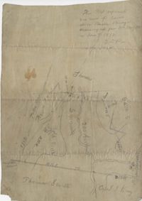
Plat of 200 acres above Bacon Bridge surveyed for William Drayton. Details include the property lines, trees, the location of the swamp, a field, a canal and roads. Names associated with this plat are Joseph Coachman, William Drayton, Thomas, Thomas Smith, J.J. Keersy [?], Chandless, Gales, and J.H. Waring. Notable geographic locations include Mary Creek Swamp [?], Broad Road, and Bacon Bridge.
Plat of 380 acres on a great swamp near Coll. Pen Bay. Names associated with this plat are John Jones, Joseph Haynes, Lewis Oglesbee, M. Cattersloni [?], and John Rofe.
Plat of 1199 acres in St. Johns Parish. Names associated with this plat are Daniel Gelyer, Peter Sanders, James Rown, Thompson, Meadwell, S. Brichelle [?] and Maun. Notable geographic locations include Berkeley.
Plat of 1199 acres of land in St. John’s Parish; little geographical information. Names associated with this plat are Robert Daniel, Brichell, Treadwell, William Maime [?], James Rown, John Frierson, and Peter Sanders.
Plat contains 500 acres on the Edisto River. Names associated with this plat are William John Gerardeau, John Stock, William Livingston, Thomas Broughtors, Charles Craven, Charles Parker. Notable geographic locations include South Edisto River and Colleton County.
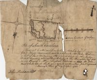
"350 acres granted to Thomas Smith on the 28th March 1694, Bounding [?] On Medway River South on land formerly laid out to Robert Skelton and went north…" Names associated with this plat are Thomas Smith and Robert Skelton.
120 acre plot purchased by George Rivers, shows Bohicket Creek and several smaller creeks, also denotes some marsh, highland, and riverbanks, the plot of land is divided into six smaller plots with "Broad Road" running between them. Names associated with this plat are John Rivers, Dr. Micah Jenkins, James Stanyon, George Rivers, Hearn, Matthews, Solomon Freer, William Spencer, James Rivers, John Taylor, Margaret Simpson, William Holmes, John Holmes and James Legare. Notable geographic locations are Bohicket Creek, Johns Island, and Colleton County.
"Pursuant to a Warrant for, [?] Mitchell Esquire Surveyor General Sha [?] Ad measured and laid out unto William Peter Reahimer a tract of land containing 136 acres situated in Charleston District, bounding SW on land belonging to Thomas Broughton Esquire South on land belonging to William Singleton [?] on Mr. John Ansil and has such shape and mark as the above plat represents Surveyed 9th day of April 1785." Includes two water sources dividing the property. Names associated with this plat are William Peter Redhimer, Thomas Broughton, William Singleton, John William Ansil, and John Richardson.
Persuant to [?] from Ephraim Mitchell Esquire Surveyor General that admeasured and laid out un to William Peter Redhimer a tract of land containing 97 acres of land situated in Charleston District bounding NW [?] as represented in the plat and hath such shape and marks as the above plat Surveyed this 9th day of April 1785. Names associated with this plat are William Peter Redhimer, John Richardson, Colonel Isaac Motte, Thomas Singleton, Reating Simoner, Ephraim Mitchell and Keating Simone.
"Plan of a Plantation containing 240 acres in St. Andrew’s parish belonging to William Newbenny. Surveyed by N. Brandwill March 1772. Copy taken from the plan in the property of William Newbenny." The plat also contains the location of a structure and a road leading to it. Plantation located on East side of Ashley River. Names associated with this plat are William Mewhening, N. Brandwill, Whitenarth Tuller, William Scotts, Ralph Izard, the Lords Proprietors, William Williams and William Scott.
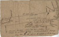
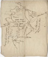
4000 acre plot of land for James Peach with its natural boundaries being rivers instead of property lines, also shows surrounding properties and their names. Names associated with this plat are James Peach, Lowright and Ellis Barce. Notable geographic locations include New River, Wrights River, Daufuskie Island, New River, Wright’s River, The North River, Cuningham Point, Savannah River, Black Oyster Bank, Turrapin Beech, Pine Island Creek, Red Bluff, and Townbridge Landing.
Plat includes 272 Acres with the Broad Road bisecting the property. Names associated with this plat are William Perry Perry, N. Bradwell, Archer Smith, the Ministry Lands and Joseph Perry. Notable geographic locations include St. George’s Parish, Bach Hill, Dorchester, and Broad Road.
Plat of 1000 acres is surrounded by vacant land. Names associated with this plat are John Stuart. Notable geographic locations include Berkeley County and St. Stephen's Parish.
Plat of 202 acres in St. James Goose Creek belonging to James Headright. Details include trees on the property line and the names of neighboring property owners. Names associated with this plat are James Headright.
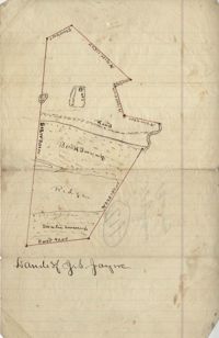
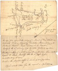
Unnamed plot of land that is divided into four parts, Santee swamp, ridge, Buck Swamp, and the section that includes a road and the house, no measurements or surrounding details. Names associated with this plat are G.S. Jayne.
Copy of two tracts of land A and B. A containing 1144 acres, and B, containing 580 located north of the Santee River and Duck Creek for Georgetown District. John Hutchinson, Chardon, Laroche, Foijsin, Gail Huger, Isaac Huger, Mark Hugin, Ford, Job. Rothmaklen, Jospeh Purcell and Charles Parker. Notable geographic locations include Mosquito Creek, Four Mile Creek, Belin Creek Duck Creek, Minim Creek, Santee River, Winyaw Bay, and Georgetown District.
296 acres of land conveyed to Alexander Walker to John Sumer and M. Weston executors of the last will and testament of Richard Downs (1705). Names associated with this plat include Richard Downs, Smith, Joseph Stanyarn, Coats, Alexander Walker, John Sumer, Plowden Weston, Roper and Chrisby [?]. Notable geographic locations include Broad Road to Jacksonborough and Stono.
56 acre plot of land given to Radcliffe, the plot of land is bordering Cuckolds Creek, shows surrounding property owners, no land type detail or identification. Names associated with this plat are Thomas Radcliffe, Nathaniel Heyward, John Goddard and James Heyward. Notable geographic locations include Cuckolds Creek, Combahee River and St. Bartholomew's Parish.
179 acre plot of land given to Mr. Webster, shows the property lines and no land type detail. Names associated with this plat include Webster, Peters, Branford, and John James Haig. Notable geographic locations include the Pon Pon River.
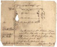
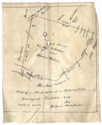
Plan of land in St. James Santee for Abraham Micheau. Names associated with this plat are Ann Colburn, Gardner, Anthony Germain, Buneli, B. Skipper, Isaac Skipper, Abraham Micheau, and William H. Simons.
Copy of plat of land being 903 belonging to Archer Smith in Georgetown District on the side of Pee Dee. Names associated with this plat are Archer Smith, Thomas Water, Abraham Livingston, J. Roshnakler, W. Glover, Preugh [?], Thomas Skrine [?], John J. Pringle, Alexander Roses and John Coates. Notable geographic locations include Pee Dee, Georgetown District, and Path to Black River from Pee Dee.
Plat of land with unknown acreage on Wadmalaw Island. Names associated with this plat include Gibbs, Wescot, and Benjamin Walter. Notable geographic locations include St. John's Parish, Wadmalaw Island, Colleton, and Public Road to Beau Bluff.
Plat of land near Pocotaligo. Very little information and explanation are included. The land looks to be near a crossroads and some form of water. Names associated with this plat are Cuthbert. Notable geographic locations include Augusta Road, Cossawhatchie [Coosawatchie], Pocotaligo, and Prince William's Parish.
Plat contains 1000 acres. Names associated with this plat include William Liott and David Celiphairch [?]. Notable geographic locations include St. George Parish.
58 acres of land laid out unto M. Belin situated on Sandy Island. Names associated with this plat are John Hardwick, Thomas Waring, Broughton and Postell.
Plat of land of 64 acres laid out for Allard Belin situated on Sandy Island. Names associated with this plat are Allard Berlin, John Hardwick and D.T. Waring.
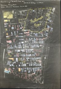
Six maps conveying plans to beautify Ansonborough, showing the footprints of buildings and annotated to indicate the status of buildings, traffic flow, and scenarios that would result from the Ansonborough Rehabilitation Project.
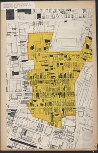
Hand-drawn and color-coded map of Ansonborough indicating properties purchased by HCF, restored by HCF, for sale by HCF, restored privately, and other distinctive antebellum houses. Created to illustrate HCF’s Ansonborough Rehabilitation Project.
"A Plan of a Plantation or Tract of Land on Penny Creek a Branch of Ponpon or Edisto River late the property of Joseph Bee Esquire now belonging to John Champney Esquire." Plat contains 687 acres on the north side of Penny Creek the plat is divided by use of lands and the location of structures on the property. Names associated with this plat are John Champney, Dr. John Mitchell, Thomas Bee, Joseph Bee, and George Savage. Notable geographic locations include Penny Creek, Edisto River, Pon Pon River, Landing Road, and Bridge Road.
Copies of Sanborn Map pages combined to study maps of various areas in Charleston. Color-coded to depict building status. Second image provides key for color coding.
Map of Ansonborough showing Meeting Street, King Street, Hasell Street, Maiden Street, Old Church Street, Bay Street, and others. A small piece of paper taped to the back reads: "Kindness of: Mr. Gedney M. Howe."
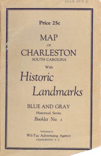
Map of the Charleston peninsula featuring points of interest. Cover title: Map of Charleston, South Carolina with historic landmarks. Blue and gray historical series, booklet no. 1. Published by Wil-Tuc Advertising Agency. Map measures 21” x 6.25” folded to create 13 pages measuring 6.25” x 3.5.
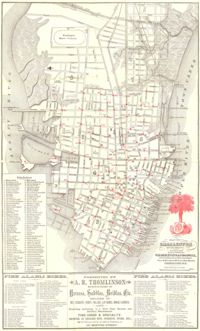
Map of the Charleston peninsula. Revised in 1879; published by Walker, Evans & Cogswell. Features locations of fire alarm boxes and public buildings, with indexes to each. Presented by A.R. Thomlinson, manufacturer of harness, saddles, bridles, etc., located at 137 Meeting Street. Measures 21.875" x 13.625"
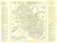
Map of the Charleston peninsula with historic points of interest identified and noted. Includes a welcome to visitors by Mayor Burnet R. Maybank and a map of "The Garden Club Walk" route. "Released by the Office of Port Development." Measures 16" x 22".
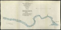
These five maps of the Waccamaw River in Horry County, S.C., show the river from Conway to Bull Creek. The surveys, dated November 1903, were performed under the direction of Captain G. P. Howell, Corps of Engineers U.S.A., and Reid Whitford, U.S. Assistant Engineer. The surveyor was William H. Johnstone.
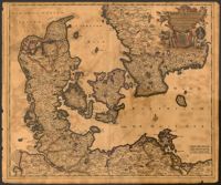
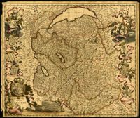
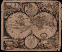
Map of Denmark with the Baltic Sea and the southern portion of Sweden by Justus Danckerts (1635-1701). Title cartouche displays the Danish coat of arms. 52 x 62cm.
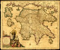
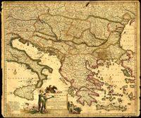
Map of the Peloponnese in southern Greece by Justus Danckerts (1635-1701). Written next to many cities on the map (Athens, Corinth) are the dates they were recovered by the Venetians from Ottoman control. Latest date found on map is 1687. Title cartouche depicts the Venetian lion towering over Turkish soldiers. Amsterdam. 52 x 62cm.
One of three maps by Nicolaes Visscher (1649-1702) collectively showing the entire length of the Danube. This map covers the middle part of the river from Linz through Vienna, Bratislava and Budapest, to just east of Belgrade. Amsterdam. 52 x 62cm.
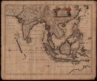
This map was engraved by Johannes L'Huilier and corrected by Frederick de Wit (1630-1706). The map encompasses the regions from India to Southern China, Taiwan, the Philippines, the East Indies and Indonesia with parts of northwest Australia identified as Hollandia Nova. Many islands with their ports are shown. The title cartouche at the top right is surrounded by turbaned warriors and native figures. 52 x 62cm.
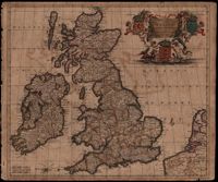
Map of the British Isles by Theodore Danckerts (1663-1727) also includes part of the European coast. The decorative title cartouche is in the upper right corner with putti supporting the shields of Scotland, Ireland and England; the mileage scale is given in the lower left corner. Amsterdam. 52 x 62cm.
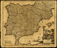
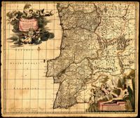
Map of Portugal and Algarve by Johannes de Ram (1648-1693). The title cartouche in the upper left depicts cherubs holding the Portuguese coat of arms; a note within the cartouche explains that the longitudinal lines on the map are based from the prime meridian that runs through Tenerife in the Canary Islands. The scale cartouche in the lower right features Neptune with a trident and two cherubs holding the coat of arms of Algarve, then a semi-autonomous region of Portugal. Amsterdam. 52 x 62cm.
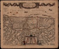
This map was engraved by Frederick de Wit (1630-1706), one of the most prominent and successful publishers in Amsterdam. The Holy Land extends from Sidon and Damascus to the Wilderness of Pharan in the Sinai. The decoration in the map relates to the Old Testament. At the bottom of the map is a depiction of an encampment of the Israelites during Exodus. The Twelve Tribes are around the perimeter and in the center the Tabernacle is illustrated with the Levites in attendance. Moses is at the left holding his staff and his brother Aaron is opposite. The caption in the sea refers to Lebanese cedars being sent by King Hiram of Tyre to King Solomon. The theme of the richness of the Promised Land is emphasized with the beautiful garland supported by the angels across the top, containing fruit, grapes and flowers. North oriented to the right. Amsterdam. 52 x 62cm.
One of three maps by Nicolaes Visscher (1649-1702) collectively showing the entire length of the Danube. This map depicts the lower Danube from Belgrade to its mouth in the Black Sea. Amsterdam. 52 x 62cm.
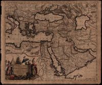
A map of Turkish possessions including Egypt and Greece by Justus Danckerts (1635-1701) shows the Arabian peninsula in the center. A decorative cartouche adorned with several costumed figures, a pyramid, and lions. Amsterdam. 52 x 62cm.
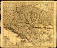
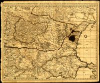
Map by Justus Danckerts (1635-1701) covers the Danube River from Germany to the Black Sea. Depicts all of the Balkans, Hungary, Romania and parts of Austria, Italy and Germany. The map was apparently printed at the height of the Ottoman wars against the European powers in the late seventeenth century. A table in the lower left depicts the names of cities in the Hungarian kingdom that were lost to the Ottomans and when they were recovered to date. The latest date on the table is 1687. However, according to the table, the recapture of Buda (Budapest) took place in 1686 but an examination of Buda on the map reveals a date of 1688. Other known examples of this map include the recovery of Belgrade (Belgrado) in 1688 in the table although this version of the map does not. It is possible this map was printed immediately before the Siege of Belgrade in 1688 or after 1690 when the city was reclaimed by the Turks (and the subsequent reference to Belgrado in the table may have been expunged). Title cartouche depicts a Christian saint and the Hapsburg eagle. Amsterdam. 52 x 62cm.
One of three maps by Nicolaes Visscher (1649-1702) collectively showing the entire length of the Danube. This map depicts the upper Danube from its start in Germany to Bratislava (Presburg on map). Amsterdam. 52 x 62cm.
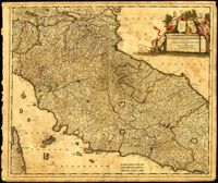
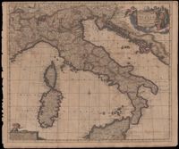
Map of central Italy by Frederick de Wit (1630-1706) showing the grand duchy of Tuscany and the papal states. Title cartouche is decorated with the ball-motif shield of the Medici family; the papal states are represented by the Keys of St. Peter on a shield. Detail on the map includes a road that extends from Rimina on the Gulf of Venetia to Piacenza in the northeast. Amsterdam. 52 x 62cm.
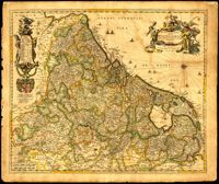
Very elaborate map of the Seventeen Provinces of the Low Countries by Gerrit Van Schagen (1642-1690). North oriented to the right. Figures in title cartouche in upper right include Athena and Pheme. Elaborate explanatory key at upper left. Dangling from the key cartouche is the family crest of Johan Munter, a Dutch East India Company director and burgomaster of Amsterdam. His importance in Amsterdam is evident in the text below the key. 52 x 62cm.
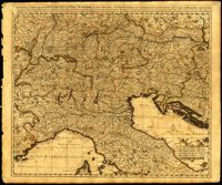
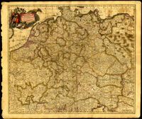
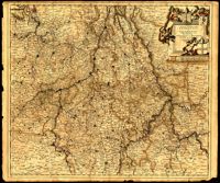
Map of central Europe by Justus Danckerts (1635-1701). Map extends from France in the west to Poland in the east and from Croatia and Italy in the south to the Netherlands in the north. The Hapsburg eagle holds the title banner in the upper left cartouche. Amsterdam. 52 x 62cm.
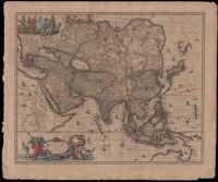
Map of Asia by Gerrit Van Schagen (1642-1690) showing the north coast of Australia and part of the Gulf of Carpentaria. Title cartouche on lower left shows Tritons, sea nymphs and Nereids. On upper left costumed natives are shown with a palm tree, monkey and beaver. 52 x 62cm.
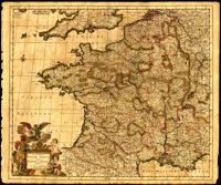
Map of France by Justus Danckerts (1635-1701) includes Belgium and Luxembourg and parts of Switzerland, the Netherlands, Germany and England. Title cartouche depicts a Roman soldier and other allegorical figures. Amsterdam. 52 x 62cm.
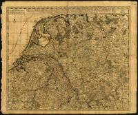
Map of Belgium by Nicolaes Visscher (1649-1702) with Luxembourg and parts of France, the Netherlands and Germany. Title cartouche in upper right corner shows resting warriors and cherubs. A harvest scene surrounds the scale in the lower left corner. Amsterdam. 52 x 62cm.
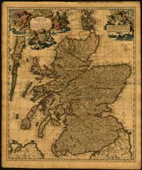
Map of the Kingdom of Scotland by Nicolaes Visscher (1649-1702). Cherubs, unicorn, lion and the Scottish coat of arms decorate the title cartouche and scale. Scale given in Scottish, German and French mileage. Amsterdam. 52 x 62cm.
Map of the Italian piedmont by Thomas Blaeu (1596-1673). Similar to Tabula Generalis Sabaudiae by Blaeu and slightly overlapping in coverage. First published by Blaeu's heirs after his death in his town book of Savoy and Piedmont. Map was designed by Giovanni Tommaso Borgonio (1620-1683) and engraved by Johannes de Broen (1649-1730). Amsterdam. 52 x 62cm.
Ornate map of Savoy in the French alps by Joan Blaeu (1596-1673). Map is richly detailed with pictorial relief of mountains and watersheds. Putti hold the coat of arms of the dukes of Savoy above the title cartouche in the lower left corner. Other family crests from the regional duchies and baronies ring the map. First published by Blaeu's heirs after his death in his town book of Savoy and Piedmont (Theatrum Sabaudiae). Map was designed by Giovanni Tommaso Borgonio (1620-1683) and engraved by Johannes de Broen (1649-1730). Amsterdam. 52 x 62cm.
This map by Theodore Danckerts (1663-1727) details the bishoprics of Liege, Cologne and Trier and the duchies of Berg and Julich. Map covers the area surrounding the Meuse, Rhine and Moselle rivers and includes parts of modern day Belgium, the Netherlands, Germany, Luxembourg and France. Decorative title cartouche with putti holding the shields of the regions. Amsterdam. 52 x 62cm.
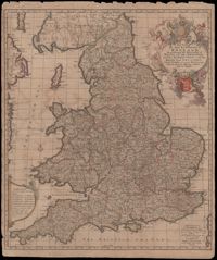
A very informative map of the road network with England and Wales. This map was cooperatively published by Nicholas Visscher (1649-1702), a cartographer from Amsterdam, and John Overton (1640-1708), a publisher from London. The imprint of Visscher and Overton tells the reader that the map may be bought in both Amsterdam and London. The maps title is enclosed in a decorative cartouche on the upper right. At the top of the title is the royal coat of arms supported by a lion and a unicorn and at the bottom is the shield of England. Amsterdam. 52 x 62cm.
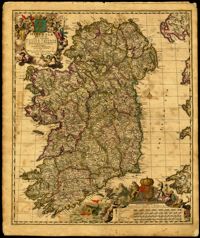
Decorative map of Ireland by Nicolaes Visscher (1649-1702). Impressive title cartouche with Pan and the Gaelic harp. Highly decorative scale of miles references William III, king of England, Scotland and Ireland 1689-1702. Visscher created this map shortly after William Petty's exhaustive survey of Ireland (the Down Survey) was published. Amsterdam. 52 x 62cm.
In this map by Gerrit van Schagen (1642-1690) California is a large island, there is one Great Lake (Lac contenant), a large open lake in place of the western Great Lakes, and the conjectural Northwest Passage, with the Straits of Anian. The elaborate title cartouche at the bottom left contains scenes of native Americans hunting, panning for gold and a chief standing beneath an umbrella. Also, the map shows other small illustrations: a war being waged by Indians in South America and a figure lying in a hammock. There is a large vignette at the top left of Neptune and his sons, the Tritons. 51 x 62cm.
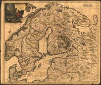
Map of Scandinavia by Justus Danckerts (1635-1701) includes the Baltic and part of Russia. The title cartouche with an armorer's forge and Swedish coat of arms probably alludes to Sweden's power in the late seventeenth century. 52 x 62cm
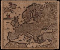
Map of Europe by Justus Danckerts (1635-1701) includes western Russia and Iceland. The title cartouche on left supported by putti. Other embellishments show the abduction of Europa by Zeus, a sea monster and ships on the oceans. Amsterdam. 52 x 62cm.
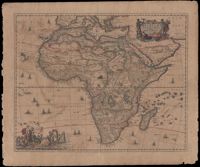
The map by Gerritt Van Schagen (1642-1690) captures the European misconceptions of Africa typical of the late seventeenth century. The Nile appears to be rising from the three lakes of Zaire, Zembre and Zafflan. The prime meridian, the zero-degree longitude line, is plotted through the Canary Islands which to the ancients was the western edge of the inhabited world. The interior is decorated with monkeys, elephants, lions, rhinoceroses, leopard and ostriches. The sea is decorated with ships, whales and flying fish. The title cartouche in the upper left right is surrounded by two Africans, one holding a scorpion and the other a cornucopia with sea sprites at their feet. The elaborate decoration at the lower left is Neptune surrounded by his wife, Amphitrite, and their sons, the Tritons, along with Nereids, the sea nymphs. 52 x 62cm.
This double hemisphere map by Justus Danckerts (1635-1701) is accompanied by two small hemispheres based on the North and South Poles. The South Pole only includes the southernmost tip of South America. The North Pole shows parts of North America, Europe, and Asia. Four scenes surround the map and symbolize the four elements: fire, air, earth and water. In the upper left scene fire is symbolized with a scene of war and destruction and by Cerberus, the three-headed dog who guarded the gate to Hades. The upper right scene is of air with Olympus and the zodiac. The bottom left depicts earth with a pastoral scene symbolizing peace. Ships, a sea monster (whale), Neptune with his wife Amphitrite and their sons, the Tritons, all represent water in the lower right scene. "M King" 1811" written on upper right. Amsterdam. 52 x 62cm.
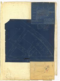
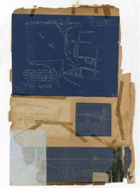
Page 259 of the City Engineer's Plat Book with three plats. Plat 1 shows lots located between Hester Street and Piedmont Street. Plat 1 also shows Alberta Street, Poplar Street, and a stretch of marsh land. Plat 2 shows lots located between Tradd Street, Ashley Street, and Murray Boulevard. Plat 2 also shows South Bay Street. Plat 3 shows a city block between Hester Street and Piedmont Avenue, and between Poplar Street and Alberta Avenue.
Page 256 of the City Engineer's Plat Book with four plats. Plat 1 shows land located between Elliot Street and Boundary Street, near Mill Street, Bee Street, President Street, and Doughty Street. It also shows several streams, a mill pond, and a large stretch of marsh land. Plat 2 shows a lot on Brigade Street. The third plat shows a lot and building located on the corner of Grove Street and Russell Street. The fourth plat shows lots located near the intersection of Grove Street and Tracy Street.
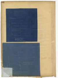
Page 248 of the City Engineer's Plat Book with two plats. Plat 1 shows lots and structures located between Wescott Court and President Street, north of Bee Street. Plat 2 shows lots on and near Huger Street, King Street, Congress Street, and Benson Street.
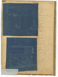
Page 252 of the City Engineer's Plat Book with two plats. Plat 1 shows lots on and near Lenwood Street, between South Bay Street and Boulevard Drive. Plat 2 shows lots located on and near the intersection of Huger Street and Rutledge Avenue.
Page 251 of the City Engineer's Plat Book with two plats. Plat 1 shows Meeting Street, Williman Street, and Romney Street. Plat 2 shows lots located on and near America Street, Lee Street, Cooper Street, and Drake Street.
Page 257 of the City Engineer's Plat Book with two plats. Plat 1 shows lots located between St. Margaret Street and Grove Street. Plat 2 shows lots located along Marsh Street and Concord Street, near where they intersect with Laurens Street.
Page 255 of the City Engineer's Plat Book with two plats. Plat 1 features lots located between St. Margaret Street and Grove Street, and between Tenth Street and Eleventh Street. Plat 2 features lots and structures located on the intersection of Aiken Street and Hampden Court.
Page 250 of the City Engineer's Plat Book with one plat. The plat shows lots between Romney Street and Williman Street, and east of Meeting Street. The plat also shows Isabella Street.