01. Nova Totius Terrarum Orbis Tabula
Close Viewer
- Title:
- 01. Nova Totius Terrarum Orbis Tabula
- Date:
- 1682
- Creator (Personal):
- Danckerts, Justus, 1635-1701
- Description:
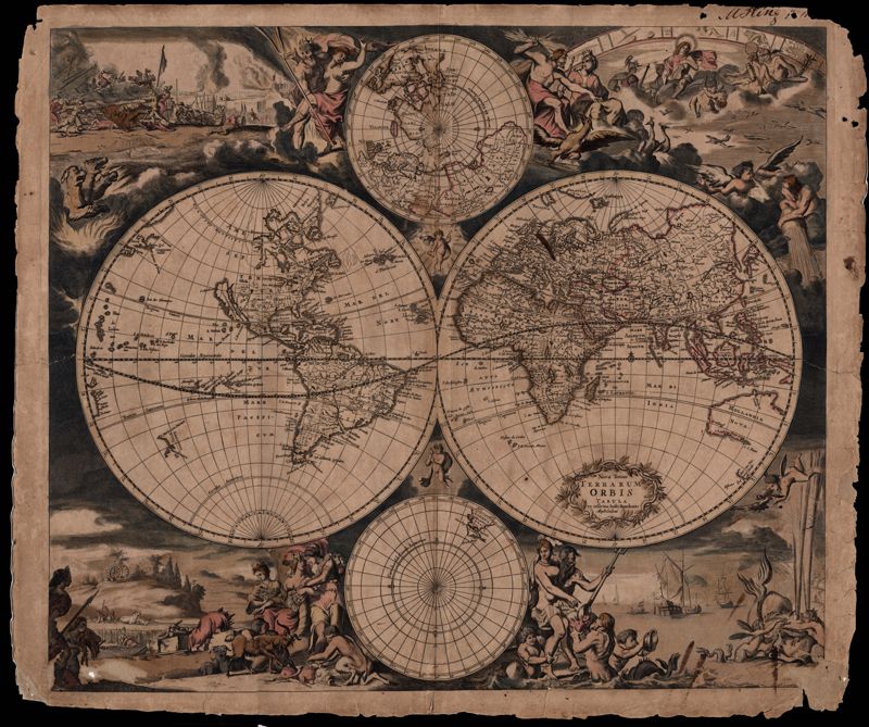
- This double hemisphere map by Justus Danckerts (1635-1701) is accompanied by two small hemispheres based on the North and South Poles. The South Pole only includes the southernmost tip of South America. The North Pole shows parts of North America, Europe, and Asia. Four scenes surround the map and symbolize the four elements: fire, air, earth and water. In the upper left scene fire is symbolized with a scene of war and destruction and by Cerberus, the three-headed dog who guarded the gate to Hades. The upper right scene is of air with Olympus and the zodiac. The bottom left depicts earth with a pastoral scene symbolizing peace. Ships, a sea monster (whale), Neptune with his wife Amphitrite and their sons, the Tritons, all represent water in the lower right scene. "M King" 1811" written on upper right. Amsterdam. 52 x 62cm.
- Collection Title:
- Mitchell King Atlas, 1662-1695
- Contributing Institution:
- College of Charleston Libraries
- Media Type:
- Maps
- Topical Subject:
- Atlases, History, Modern -- 17th century, and World maps
- Language:
- Latin
- Shelving Locator:
- Mss 0091
- Date Digital:
- 2008-10
- Digitization Specifications:
- 360 ppi, 24-bit depth, color, Epson Expression 10000XL, Archival Master is a tiff. Images merged in Adobe Photoshop.
- Internet Media Type:
- image/jpeg
- Copyright Status Statement:
- Public domain.
- Access Information:
- For more information, contact Special Collections, College of Charleston Libraries, 66 George Street, Charleston SC 29424.
- Admin ID:
- 49230
Permalink