09. A New Mapp of The Kingdome of England
Close Viewer
- Title:
- 09. A New Mapp of The Kingdome of England
- Date:
- 1688
- Creator (Personal):
- Visscher, Nicolaes, 1649-1702
- Contributor:
- Overton, John, 1640-1708? (bookseller, London)
- Description:
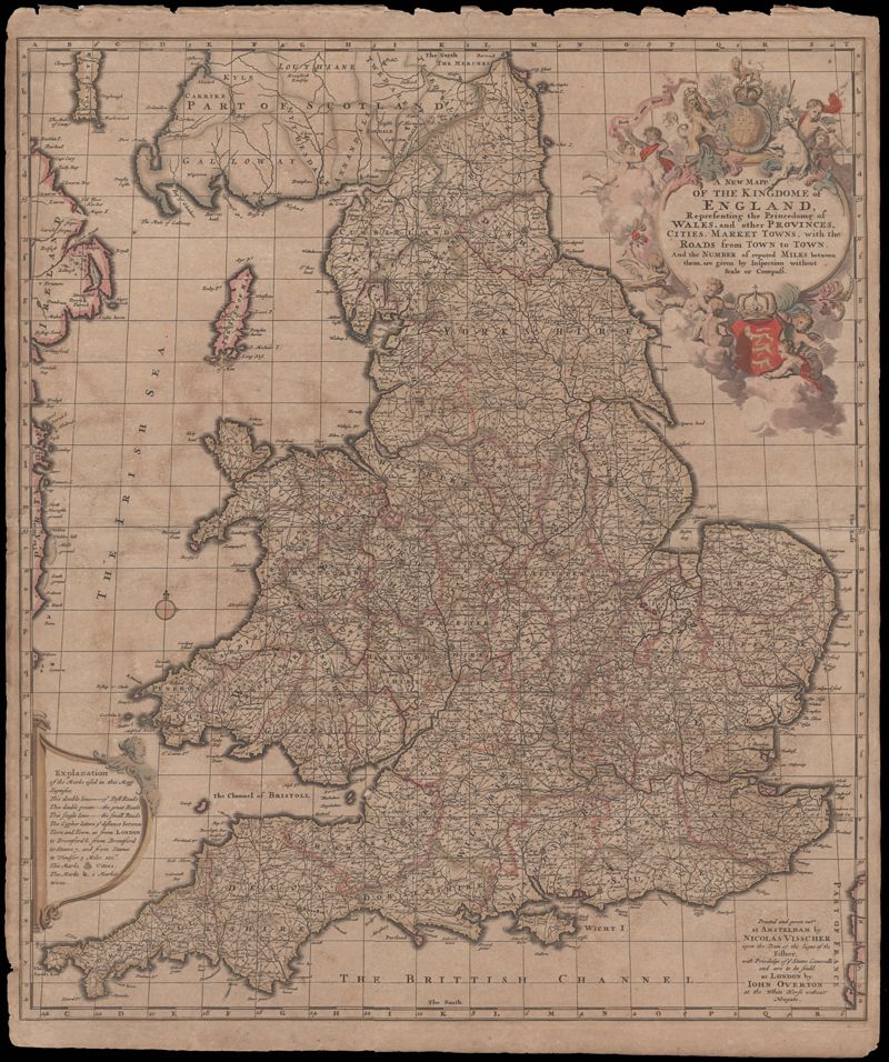
- A very informative map of the road network with England and Wales. This map was cooperatively published by Nicholas Visscher (1649-1702), a cartographer from Amsterdam, and John Overton (1640-1708), a publisher from London. The imprint of Visscher and Overton tells the reader that the map may be bought in both Amsterdam and London. The maps title is enclosed in a decorative cartouche on the upper right. At the top of the title is the royal coat of arms supported by a lion and a unicorn and at the bottom is the shield of England. Amsterdam. 52 x 62cm.
- Collection Title:
- Mitchell King Atlas, 1662-1695
- Contributing Institution:
- College of Charleston Libraries
- Media Type:
- Maps
- Alternate Title:
- A New Mapp of The Kingdome of England Representing the Princedome of Wales, and other Provinces, Cities, Market Towns with the Roads from Town to Town. And the Number of reputed Miles between them, are given by Inspection without Scale or Compass.
- Topical Subject:
- Atlases and History, Modern -- 17th century
- Language:
- English
- Shelving Locator:
- Mss 0091
- Date Digital:
- 2008-10
- Digitization Specifications:
- 360 ppi, 24-bit depth, color, Epson Expression 10000XL, Archival Master is a tiff. Images merged in Adobe Photoshop.
- Internet Media Type:
- image/jpeg
- Copyright Status Statement:
- Public domain.
- Access Information:
- For more information, contact Special Collections, College of Charleston Libraries, 66 George Street, Charleston SC 29424.
- Admin ID:
- 49234
Permalink