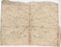
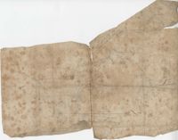
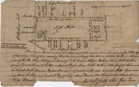
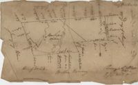
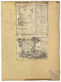
Farm of 54 across for sale by Rutherford, individual plots lettered A-S. Names associated with this plat are Birkman, Rutledge Phokes, Fitch, Kinsman and Rutherford. Notable geographic locations include Broad Street and Dorchester Road.
Office copy of a tract of land once belonging to Thomas Nau then John S. Cripps containing 277 1/2 acres. The land includes gum, white and red oak, and cedar trees along with posts, a rice field and a bridge over the public road from Rantoles [Rantowles] to Charleston. Names associated with this plat include John S. Cripps, Thomas Nau, and S. Lewis.
Copy of a plat of 250 acres laid out to Abraham Michau on the north side of Santee River and “now belonging to John Pedro." Names associated with this plat are Abraham Michau, John Pedro, George Hunter and James Glen. Notable geographic locations include the Santee River, Prince Frederick Parish and Georgetown District.
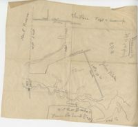
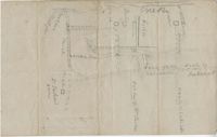
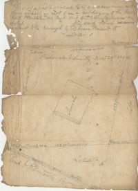
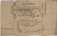
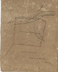
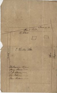
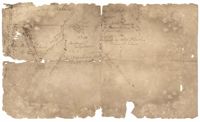
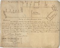
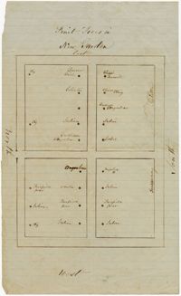
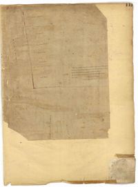
Plat of 53 acres off of Dorchester Road which is divided into lots. Very little details or information. Names associated with this plat are Fitch and Beckman. Notable geographic locations include Dorchester Road.
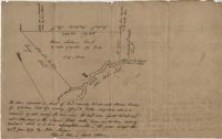
Sketch of property including roads and fields, some specific house names like Rectory house and W. Dotolhinese's house. Names associated with this plat are Glisbe, Priohau, Dotolhinese and Glebe. Notable geographic locations include St. Johns Parish, Broad Road, Wadboo [?] Bridge, Road to Pontauxs, and Road to Cordyville [?].
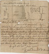
Plan of a body of land now part belonging to Mr. George Summers and part to John Summers and part of the estate of Brigdon Smith lying at Stono adjoining lands of S. Matlock. Names associated with this plat are John Summer, George Summer, Brigdon Smith, Malleck, J. Fenwich, Edward Bellinger, Christopher Wilkenson, John Tucker, W. Owen, Henry Hyrne, Inch, Downs, Elizabeth Elliott, George Tommer, Thomas Farr, Smith Mellichamp, and Ann Downs. Notable geographic locations include New Road, St. Paul's Parish and Stono.
Plan of a tract of land belonging to George Chisolm. Names associated with this plat are George Chisolm, John Scott, A. Andrew, Thomas Hollingsby [?], and Thomas. Notable geographic locations include the Ashley River and Kuskawah [Kushiwah] Creek.
Plat consists of 900 acres. Names associated with this plat include Rero A. Stoble, James Bullock and H. Bryan. Notable geographic locations include Savannah and St. Peter's Parish.
300 acres of land belonging to Richard Downes at Stono. Names associated with this plat include Richard Downes, Edmond Bellinger, Thomas Mellichamp, Christopher Welkin and Archibald Stanyarn.
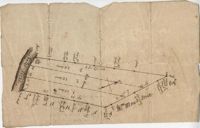
Plat of land laid out to Huggins of 58 acres situated on the NE side of Pee Dee River butting and bounding to the North on William Alston's land and to the south and southwest on unknown land. Names associated with this plat are Huggins, William Alston, Job Roshmahler and John Hardwick.
Plat includes 500 acres on the Cypress Swamp. Names associated with this plat are James Sanders, Matthew Nelson, William Abraham, Abraham Sanders, and Samuel Sanders. Notable geographic locations include St George’s Parish, Cypress Swamp, Dorchester, and Thorntree Swamp.
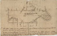
A quarter of an acre including a church on Marsh Field Plantation. Names associated with this plat are Thully T.G. Beneyor, Frederick Smith, J.G. Sturly, Rebecca Bennett and Rantowle. Notable geographic locations include St. Andrews Parish, Marsh Field Plantation, and Road to Rantowle's Ranch.
Copy of a plat part now belonging to Benjamin Perry and part to John Pringle on the west side of Ashley River. Names associated with this plat include John Pringle, Benjamin Perry, John Julius Pringle, Lambert Lance, Abraham Ladson, Sarah Rose, Nathaniel Bradwell, Ephraim Mitchell, Thomas Drayton, John Frazer, Frances Baker, Thomas Osborn, Isaac Landson, Isaac Perry, John Drayton, Glen Drayton, Francis Ladson and W. John Cattle. Notable geographic locations include the Ashley River, Charleston, Berkeley County, and Ashley River Road.
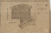
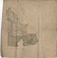
Plat of Hopewell Plantation with surrounding lands owned by several people, shows the Edisto River and an unnamed settlement, labels the land in the center as uncleared land while swamps, roads, rivers and trees surround it. Acreage unclear. Names associated with this plat are Baring, Branford, Mellechamp, Colonel W. Hayne and Arthur Middleton. Notable geographic locations are St. Paul's Parish, Edisto River, and Willtown Road.
Plat of two tracts of land (1000 acres) adjoining each other on the north side of the Santee River now belonging to the estate of Brown. Copy from the plat annexed to the orginal grants from the Lords Proprietors. Names associated with this plat are Peter Gaillard, Brown, Henry Bruneau and The Lords Proprietors. Notable geographic locations include the Santee River and Dohov Swamp and Creek.
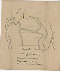
Plat of land belonging to General Cuthbert in the Beaufort District on the Pocotaligo River. Little other detail included in the plat besides the property lines and the river. Names associated with this plat include Luna Cuthbert and Cuthbert.
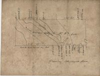
500 acres surveyed for Thomas Ditom now Paul Blare. Includes Bacon Bridge Road. Names associated with this plat are Paul Blare, Dilton, William Way and Scotte.
Plan of 101 acres in St. James Parish, Goose Creek belonging to Abram Jones. Details include roads, ports, banks, trees and a field. Names associated with this plat are Abram Jones, Thomas Middleton, and Major Benjamin Smith. Notable geographic locations include Goose Creek, Charleston District, and Black River Road.
161 acres of land southeast of Pee Dee River. Details include rivers, a canal, and trees. Names associated with this plat are Mackie and William Stitt. Notable geographic locations include Waccamaw River and Pee Dee River.
Tract of land belonging to May Ball in area known as Three Mile Head. Names associated with this plat are John Ball, Huger, Gourdin, E. Ball, May Ball and Caw. Notable geographic locations include Three Mile Head and Tartleberry.
Tract of land containing 416 acres. Details include trees, surrounding land, water, and roads. Notable geographic locations include St. John's Parish and Berkeley.
Copy of a plat of 150 acres and granted to Jobe Howes now forming part of Hickory Hill plantation in St. James Goose Creek and part in St. John and St. James Parish.
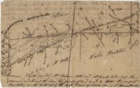
Plat of a part of Inverness sold from the estate of C. Huguenin to John Martin containing 538. Plat includes a railroad, a fort, a public road and fence. Names associated with this plat are C. Huguenin, John Martin, William Heyward, and Gunie [?]Williams. Notable geographic locations include Inverness and Pocotaligo Bridge.
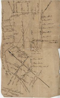
Plat of two tracts of land one for 360 acres and the other for 90 plat contains dates and names of the properties as well as a short chain of title. Names associated with this plat are John Musgrove, John Champneys, Sarah Champneys, William Stend, Robert Adams, George Jackson, Thomas Grumball, Sherriff C.D Elliott, Jabina, Col. William Ball, William John Champney, William Seads, and James St. John. Notable geographic locations include the Edisto River, Hickory Bridge and Colleton County.
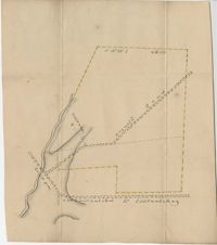
Sketch of lots near Dorchester now belonging to James Kennedy. Names associated with this plat are James Kennedy, Thomas Droger, John Dawson, M. Strom, J.H. Strom, J. Johnson, and J. Nilson. Notable geographic locations include Dorchester, St. George's Parish and Broad Road.
Plat of land belonging to Thobar butting and bounding 163 acres of land owned by Margaret Burger Master. Very little explanation of pertinent details on the plat. Names associated with this plat are Henry Thobhar, Margaret Burger Master, N. Winklin and J.L. Porcher.
Plat is laid out for 200 acres of land but when surveyor toured the land contained 547 acres apparently the surveyor did not "run the lines" properly when the land was first laid out and not setting corners. Names associated with this plat are Thomas Tucker, Archibald Crall, John Cook, Richard Ireland, Levey, John Linder, and James Stuard. Notable geographic locations include the Edisto River.
Plat of land belonging to General Cuthbert in the Beaufort District on the Pocotaligo River. Little other detail included in the plat besides the property lines, trees and the river. Names associated with this plat are Cuthbert Luna, Smith, Gordon [?], and Adam Jordan.
Plat laid out unto James St. John containing 375 acres of land in Colleton County. Names associated with this plat are James St. John, William Westbury, George Vincent, Samuel Sleigh, and John Godfrey. Notable geographic locations include Colleton County and the Pon Pon River.
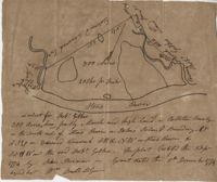
Plan of Belle Island north of Four Mile Creek consisting of 316 acres. Names associated with this plat are Middleton, Richard Lowndes, and W.R. Maxwell. Notable geographic locations include Belle Isle, Four Mile Creek, and Manquils Creek.
Resurvey of a tract of land measuring 510 acres called Egan Hall belonging to John Egan situated in St. James Parish, Santee. Names associated with this plat are John Egan, Gredless and Ball. Notable geographic locations include St. James Parish, Santee, Egan Hall, and Bunker's Hill.
Copy of a plat of 765 acres of high land and swamp and 98 acres of swamp along Pee Dee River. Names associated with this plat are Colonel Powell, Saxby, Richfield, Wood Furman and Broughton. Notable geographic locations include St. George Parish, the Pee Dee River, Churning Crop Road, Richfield Plantation, and Georgetown District.
300 acre plot being partly marsh and highland in Colleton County, on the south side it is budding with the Stono River, shows surrounding property owners and minor creeks. Names associated with this plat are Robert Gibbes, Edward Fenwak, John Bremar and Bull.
Three separate 211 acre plots (633 total) of land that are budding and bounding on the south side by the Santee River, shows some trees at the property border and surrounding neighbors. Names associated with this plat are Major Ladson and William Moultrie. Notable geographic locations include the Santee River.
Sketch of land with no measurements or names, shows some trees and unnamed road/creeks. Names associated with this plat are John Michael and J.H. Alston. Notable geographic locations include Santee River and St. James Parish.
Two parcels of land (A & B) on the south side of the south branch of the Santee River in St. James Parish, Charleston District. Names associated with this plat include Rebecca Motte and Jonah Collin. Notable geographic locations include Washo Plantation, St. James Parish, Santee and Charleston District.
Plat of 640 acres of land belonging to Thomas Roberts situated in Berkeley County on the Cooper River bounding to the North and NE on land lad out to Nicholas Aremile to the south and SW on lands of Robert Miles and all other sides on vacant land. Names associated with this plat are John Berry, Ephraim Mitchell, Thomas Roberts, Nicholas Roberts, Nicholas Aremile, Robert Miles, William Gilbert, Barfield Homan and John Diamond. Notable geographic locations include the St. John's Parish, Cooper River, Berkeley County and Charleston District.
876 acre plot for Simpson, shows roads, houses, and rivers/creeks, no names on any of the details, includes surrounding tracts of lands and trees on the property boundaries. Names associated with this plat are Simpson, Keith, James Gray Wiase, and Charles Johnston.
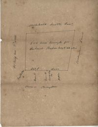
500 acres of land surveyed for Richard Bedon. Details are minor and include trees and surrounding lands. Names associated with this plat are Broughton, Archibald Smith, May Postell and Richard Bedon. Notable geographic locations include Dorchester and St. George's Parish.
Plat of land with rice fields and highlands noted along with the neighboring properties. Very little other detail or explanation given. Names associated with this plat include Carson, Isaac Waight, and Ann Stanyarn.
Plan of 500 acres of land along Turtle Island. Notable geographic locations include St. Peters Parish, Turtle Island, Wrights River, Dawfuskie [Daufuskie] Sound, Black Oyster Point, and New River.
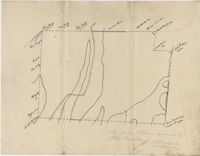
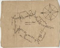
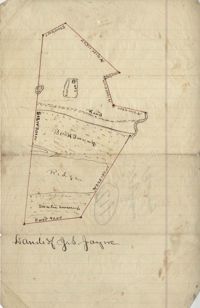
Unnamed plot of land that is divided into four parts, Santee swamp, ridge, Buck Swamp, and the section that includes a road and the house, no measurements or surrounding details. Names associated with this plat are G.S. Jayne.
Plat contains 500 acres on the Edisto River. Names associated with this plat are William John Gerardeau, John Stock, William Livingston, Thomas Broughtors, Charles Craven, Charles Parker. Notable geographic locations include South Edisto River and Colleton County.
Copy of plat of land being 903 belonging to Archer Smith in Georgetown District on the side of Pee Dee. Names associated with this plat are Archer Smith, Thomas Water, Abraham Livingston, J. Roshnakler, W. Glover, Preugh [?], Thomas Skrine [?], John J. Pringle, Alexander Roses and John Coates. Notable geographic locations include Pee Dee, Georgetown District, and Path to Black River from Pee Dee.
Plat of land with unknown acreage on Wadmalaw Island. Names associated with this plat include Gibbs, Wescot, and Benjamin Walter. Notable geographic locations include St. John's Parish, Wadmalaw Island, Colleton, and Public Road to Beau Bluff.
Plat of land near Pocotaligo. Very little information and explanation are included. The land looks to be near a crossroads and some form of water. Names associated with this plat are Cuthbert. Notable geographic locations include Augusta Road, Cossawhatchie [Coosawatchie], Pocotaligo, and Prince William's Parish.
Plat contains 1000 acres. Names associated with this plat include William Liott and David Celiphairch [?]. Notable geographic locations include St. George Parish.
58 acres of land laid out unto M. Belin situated on Sandy Island. Names associated with this plat are John Hardwick, Thomas Waring, Broughton and Postell.
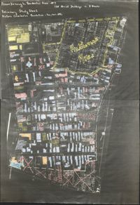
Six maps conveying plans to beautify Ansonborough, showing the footprints of buildings and annotated to indicate the status of buildings, traffic flow, and scenarios that would result from the Ansonborough Rehabilitation Project.
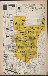
Hand-drawn and color-coded map of Ansonborough indicating properties purchased by HCF, restored by HCF, for sale by HCF, restored privately, and other distinctive antebellum houses. Created to illustrate HCF’s Ansonborough Rehabilitation Project.
Map of Ansonborough showing Meeting Street, King Street, Hasell Street, Maiden Street, Old Church Street, Bay Street, and others. A small piece of paper taped to the back reads: "Kindness of: Mr. Gedney M. Howe."
Copies of Sanborn Map pages combined to study maps of various areas in Charleston. Color-coded to depict building status. Second image provides key for color coding.
Page 254 of the City Engineer's Plat Book with one plat. A "Plat of Wagner Terrace," showing numerous lots and Hampton Park. Streets shown include Dunneman Street, Grove Street, and Rutledge Avenue.
Page 111 of the City Engineer's Plat Book with one plat. This plat shows lots located near the intersection of East Bay Street and Broad Street. It also shows a building labelled "EXCHANGE," and Gillon Street.
Page 126 of the City Engineer's Plat Book with three plats. Plat 1 shows lots and structures located between George Street and Boundary Street, and between Meeting Street and Scarborough Street. Plat 2 shows lots on Anson Street, with one building labelled "Palmetto Engine House." Plat 3 shows a large swathe of land, including marshes and streams. One stream is labelled "Vardells CK," and a line towards the right of the plat is labelled "North Eastern Rail Road." The streets on this plat include King Street, Hampton Street, Moultrie Street, Meeting Street, America Street, Bay Street, Stewart Street, Cooper Street, and Line Street.
Page 193 of the City Engineer's Plat Book with one plat. The plat shows lots located between Congress Street and Fishburne Street, and from Rutledge Street to past President Street. The plat also shows Payne Street.
Page 44 of the City Engineer's Plat Book with two plats. Plat 1 shows land between Meeting Street and a stretch of Marsh, and shows a stretch of railroad. Plat 1 also shows "Nassaw Street," Hanover Street, America Street, William Street, Isabella Street, "Rumney Street," Center Street, and "Cool-Blow Street." Plat 2 shows plats on "Rumney Street," between King Street and Meeting Street, including the intersection with Russell Street.
Page 203 of the City Engineer's Plat Book with one plat. An illustrated title card reads "A Plan of Charles Towne Copied with a Pen from an Old Dilapidated Plat without a Date," and depicts a harbor scene with Europeans and enslaved people. The plat labels landmarks and streets using capital and lowercase letters. These locations include Broad Street, the "State House," several churches, Boundary Street, the Exchange, an armory, and a beef market.
Page 214 of the City Engineer's Plat Book with two plats. Plat 1 shows lots located between Savage Street and Chisolm Street, and between Broad Street and Tradd Street. Plat 1 also shows Rutledge Avenue. Plat 2 shows a similar area to Plat 1, but also includes New Street, Franklin Street, Trapman Street, and Lynch Street.
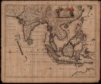
This map was engraved by Johannes L'Huilier and corrected by Frederick de Wit (1630-1706). The map encompasses the regions from India to Southern China, Taiwan, the Philippines, the East Indies and Indonesia with parts of northwest Australia identified as Hollandia Nova. Many islands with their ports are shown. The title cartouche at the top right is surrounded by turbaned warriors and native figures. 52 x 62cm.
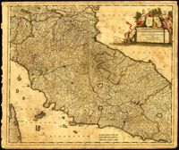
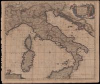
Map of central Italy by Frederick de Wit (1630-1706) showing the grand duchy of Tuscany and the papal states. Title cartouche is decorated with the ball-motif shield of the Medici family; the papal states are represented by the Keys of St. Peter on a shield. Detail on the map includes a road that extends from Rimina on the Gulf of Venetia to Piacenza in the northeast. Amsterdam. 52 x 62cm.
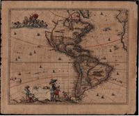
In this map by Gerrit van Schagen (1642-1690) California is a large island, there is one Great Lake (Lac contenant), a large open lake in place of the western Great Lakes, and the conjectural Northwest Passage, with the Straits of Anian. The elaborate title cartouche at the bottom left contains scenes of native Americans hunting, panning for gold and a chief standing beneath an umbrella. Also, the map shows other small illustrations: a war being waged by Indians in South America and a figure lying in a hammock. There is a large vignette at the top left of Neptune and his sons, the Tritons. 51 x 62cm.
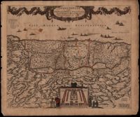
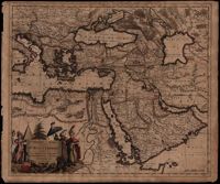
This map was engraved by Frederick de Wit (1630-1706), one of the most prominent and successful publishers in Amsterdam. The Holy Land extends from Sidon and Damascus to the Wilderness of Pharan in the Sinai. The decoration in the map relates to the Old Testament. At the bottom of the map is a depiction of an encampment of the Israelites during Exodus. The Twelve Tribes are around the perimeter and in the center the Tabernacle is illustrated with the Levites in attendance. Moses is at the left holding his staff and his brother Aaron is opposite. The caption in the sea refers to Lebanese cedars being sent by King Hiram of Tyre to King Solomon. The theme of the richness of the Promised Land is emphasized with the beautiful garland supported by the angels across the top, containing fruit, grapes and flowers. North oriented to the right. Amsterdam. 52 x 62cm.
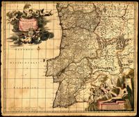
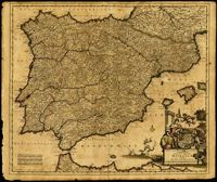
Map of Portugal and Algarve by Johannes de Ram (1648-1693). The title cartouche in the upper left depicts cherubs holding the Portuguese coat of arms; a note within the cartouche explains that the longitudinal lines on the map are based from the prime meridian that runs through Tenerife in the Canary Islands. The scale cartouche in the lower right features Neptune with a trident and two cherubs holding the coat of arms of Algarve, then a semi-autonomous region of Portugal. Amsterdam. 52 x 62cm.
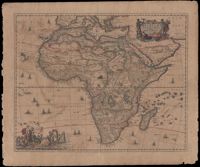
The map by Gerritt Van Schagen (1642-1690) captures the European misconceptions of Africa typical of the late seventeenth century. The Nile appears to be rising from the three lakes of Zaire, Zembre and Zafflan. The prime meridian, the zero-degree longitude line, is plotted through the Canary Islands which to the ancients was the western edge of the inhabited world. The interior is decorated with monkeys, elephants, lions, rhinoceroses, leopard and ostriches. The sea is decorated with ships, whales and flying fish. The title cartouche in the upper left right is surrounded by two Africans, one holding a scorpion and the other a cornucopia with sea sprites at their feet. The elaborate decoration at the lower left is Neptune surrounded by his wife, Amphitrite, and their sons, the Tritons, along with Nereids, the sea nymphs. 52 x 62cm.
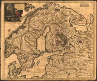
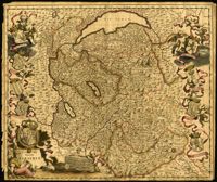
Map of Scandinavia by Justus Danckerts (1635-1701) includes the Baltic and part of Russia. The title cartouche with an armorer's forge and Swedish coat of arms probably alludes to Sweden's power in the late seventeenth century. 52 x 62cm
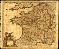
Map of France by Justus Danckerts (1635-1701) includes Belgium and Luxembourg and parts of Switzerland, the Netherlands, Germany and England. Title cartouche depicts a Roman soldier and other allegorical figures. Amsterdam. 52 x 62cm.
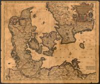
Map of Denmark with the Baltic Sea and the southern portion of Sweden by Justus Danckerts (1635-1701). Title cartouche displays the Danish coat of arms. 52 x 62cm.
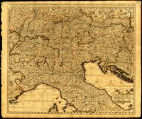
Map of the Italian piedmont by Thomas Blaeu (1596-1673). Similar to Tabula Generalis Sabaudiae by Blaeu and slightly overlapping in coverage. First published by Blaeu's heirs after his death in his town book of Savoy and Piedmont. Map was designed by Giovanni Tommaso Borgonio (1620-1683) and engraved by Johannes de Broen (1649-1730). Amsterdam. 52 x 62cm.
Ornate map of Savoy in the French alps by Joan Blaeu (1596-1673). Map is richly detailed with pictorial relief of mountains and watersheds. Putti hold the coat of arms of the dukes of Savoy above the title cartouche in the lower left corner. Other family crests from the regional duchies and baronies ring the map. First published by Blaeu's heirs after his death in his town book of Savoy and Piedmont (Theatrum Sabaudiae). Map was designed by Giovanni Tommaso Borgonio (1620-1683) and engraved by Johannes de Broen (1649-1730). Amsterdam. 52 x 62cm.
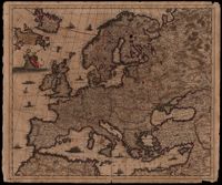
Map of Europe by Justus Danckerts (1635-1701) includes western Russia and Iceland. The title cartouche on left supported by putti. Other embellishments show the abduction of Europa by Zeus, a sea monster and ships on the oceans. Amsterdam. 52 x 62cm.
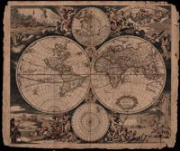
This double hemisphere map by Justus Danckerts (1635-1701) is accompanied by two small hemispheres based on the North and South Poles. The South Pole only includes the southernmost tip of South America. The North Pole shows parts of North America, Europe, and Asia. Four scenes surround the map and symbolize the four elements: fire, air, earth and water. In the upper left scene fire is symbolized with a scene of war and destruction and by Cerberus, the three-headed dog who guarded the gate to Hades. The upper right scene is of air with Olympus and the zodiac. The bottom left depicts earth with a pastoral scene symbolizing peace. Ships, a sea monster (whale), Neptune with his wife Amphitrite and their sons, the Tritons, all represent water in the lower right scene. "M King" 1811" written on upper right. Amsterdam. 52 x 62cm.
One of three maps by Nicolaes Visscher (1649-1702) collectively showing the entire length of the Danube. This map covers the middle part of the river from Linz through Vienna, Bratislava and Budapest, to just east of Belgrade. Amsterdam. 52 x 62cm.
One of three maps by Nicolaes Visscher (1649-1702) collectively showing the entire length of the Danube. This map depicts the upper Danube from its start in Germany to Bratislava (Presburg on map). Amsterdam. 52 x 62cm.
One of three maps by Nicolaes Visscher (1649-1702) collectively showing the entire length of the Danube. This map depicts the lower Danube from Belgrade to its mouth in the Black Sea. Amsterdam. 52 x 62cm.
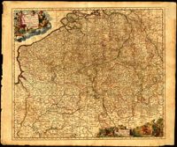
Map of Belgium by Nicolaes Visscher (1649-1702) with Luxembourg and parts of France, the Netherlands and Germany. Title cartouche in upper right corner shows resting warriors and cherubs. A harvest scene surrounds the scale in the lower left corner. Amsterdam. 52 x 62cm.
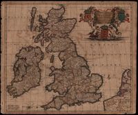
Map of the British Isles by Theodore Danckerts (1663-1727) also includes part of the European coast. The decorative title cartouche is in the upper right corner with putti supporting the shields of Scotland, Ireland and England; the mileage scale is given in the lower left corner. Amsterdam. 52 x 62cm.
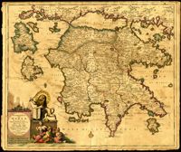
Map of the Peloponnese in southern Greece by Justus Danckerts (1635-1701). Written next to many cities on the map (Athens, Corinth) are the dates they were recovered by the Venetians from Ottoman control. Latest date found on map is 1687. Title cartouche depicts the Venetian lion towering over Turkish soldiers. Amsterdam. 52 x 62cm.
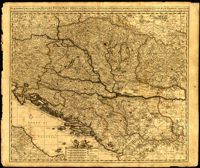
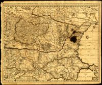
Map by Justus Danckerts (1635-1701) covers the Danube River from Germany to the Black Sea. Depicts all of the Balkans, Hungary, Romania and parts of Austria, Italy and Germany. The map was apparently printed at the height of the Ottoman wars against the European powers in the late seventeenth century. A table in the lower left depicts the names of cities in the Hungarian kingdom that were lost to the Ottomans and when they were recovered to date. The latest date on the table is 1687. However, according to the table, the recapture of Buda (Budapest) took place in 1686 but an examination of Buda on the map reveals a date of 1688. Other known examples of this map include the recovery of Belgrade (Belgrado) in 1688 in the table although this version of the map does not. It is possible this map was printed immediately before the Siege of Belgrade in 1688 or after 1690 when the city was reclaimed by the Turks (and the subsequent reference to Belgrado in the table may have been expunged). Title cartouche depicts a Christian saint and the Hapsburg eagle. Amsterdam. 52 x 62cm.
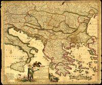
A map of Turkish possessions including Egypt and Greece by Justus Danckerts (1635-1701) shows the Arabian peninsula in the center. A decorative cartouche adorned with several costumed figures, a pyramid, and lions. Amsterdam. 52 x 62cm.
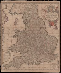
A very informative map of the road network with England and Wales. This map was cooperatively published by Nicholas Visscher (1649-1702), a cartographer from Amsterdam, and John Overton (1640-1708), a publisher from London. The imprint of Visscher and Overton tells the reader that the map may be bought in both Amsterdam and London. The maps title is enclosed in a decorative cartouche on the upper right. At the top of the title is the royal coat of arms supported by a lion and a unicorn and at the bottom is the shield of England. Amsterdam. 52 x 62cm.
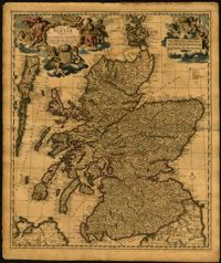
Map of the Kingdom of Scotland by Nicolaes Visscher (1649-1702). Cherubs, unicorn, lion and the Scottish coat of arms decorate the title cartouche and scale. Scale given in Scottish, German and French mileage. Amsterdam. 52 x 62cm.
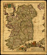
Decorative map of Ireland by Nicolaes Visscher (1649-1702). Impressive title cartouche with Pan and the Gaelic harp. Highly decorative scale of miles references William III, king of England, Scotland and Ireland 1689-1702. Visscher created this map shortly after William Petty's exhaustive survey of Ireland (the Down Survey) was published. Amsterdam. 52 x 62cm.
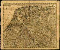
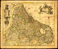
Very elaborate map of the Seventeen Provinces of the Low Countries by Gerrit Van Schagen (1642-1690). North oriented to the right. Figures in title cartouche in upper right include Athena and Pheme. Elaborate explanatory key at upper left. Dangling from the key cartouche is the family crest of Johan Munter, a Dutch East India Company director and burgomaster of Amsterdam. His importance in Amsterdam is evident in the text below the key. 52 x 62cm.
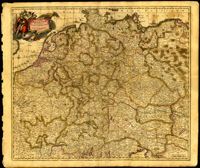
Map of central Europe by Justus Danckerts (1635-1701). Map extends from France in the west to Poland in the east and from Croatia and Italy in the south to the Netherlands in the north. The Hapsburg eagle holds the title banner in the upper left cartouche. Amsterdam. 52 x 62cm.
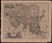
Map of Asia by Gerrit Van Schagen (1642-1690) showing the north coast of Australia and part of the Gulf of Carpentaria. Title cartouche on lower left shows Tritons, sea nymphs and Nereids. On upper left costumed natives are shown with a palm tree, monkey and beaver. 52 x 62cm.