Mary Wilkinson Memminger writes to her mother, chastising her for not writing. She also shares news from Charleston, including the news that her daughter Ellen has returned to Montpelier Institute, a school for girls in Georgia run by Bishop Stephen Elliott. She also informs her mother that they have met a distant cousin, a Dr. Borland, a sugar planter who lives in Louisiana.
Letter from Joseph H. M. Chumaciero, KKBE minister, to the Board of Trustees regarding his decision to accept his election as minister of the congregation.
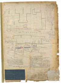
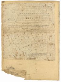
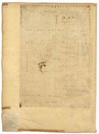
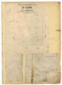
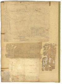
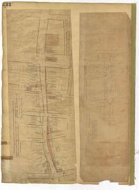
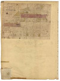
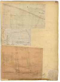
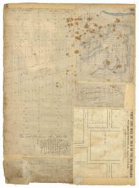
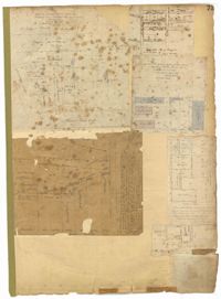
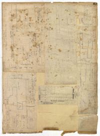
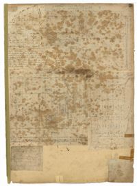
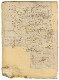
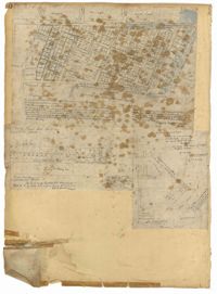
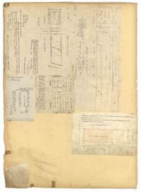
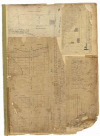
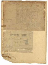
Page 1 of the City Engineer's Plat Book with four plats. Plat 1 shows the intersection of East Bay Street and Market Street, and labels reading "New Custom Ho.," "Old Flash," "Scale House," and "Market." Plat 2 shows a stretch of East Bay Street from the intersection with Guignard Street to Pritchard Street, including the bridge crossing over Canal Street. Plat 3 shows the intersection of Tradd Street and Greenhill Street. Plat 4 features Beaufain Street's intersections with St. Phillip Street and Archdale Street, and features a plot of land labelled "Normal School Yard."
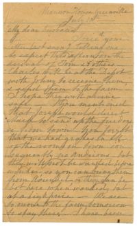
A handwritten, three-page letter from Emma Alston to her husband, Charles Alston, in which she describes the Union attack on Morris Island on July 10, 1863, and details her plans to leave Charleston the next day, including arranging a delivery of osnaburg fabric. She also states that Vicksburg has fallen.
A handwritten, two-page letter from Emma Alston to her husband, Charles, in which she arranges the arrival of six enslaved people in Greenville. She also advises him on the management of their house in Charleston and warns him to not allow enslaved people to travel without the accompaniment of a white person so as to prevent their impressment.
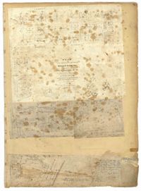
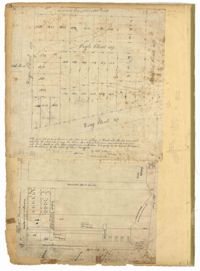
Page 10 of the City Engineer's Plat Book with two plats. Plat 1 shows plots located near Pointset Street and Grove Street between King Street and Russell Street. Plat 2 shows plots near Judith Street and Chapel Street, and includes "Beaufort's Court" and "Heyward's Court."
Page 104 of the City Engineer's Plat Book with one plat. The plat shows lots located between Moultrie Street and Cunnington Street. It also shows Lemon Street, Lee Street, Price Street, and Magnolia Street. It also shows a plat labelled "Artilery Society" and another plat labelled "Magnolia Cemetery."
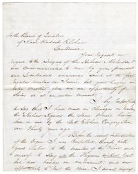
Letter to Edgar M. Lazarus from Henry S. Samuel discussing the political situation in the United States following the Civil War, family, and matters at the Liverpool synagogue.
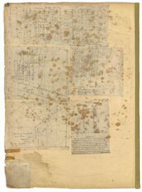
Page 11 of the City Engineer's Plat Book with five plats. Plat 1 shows a plot of land on the Charleston Harbor located near the intersection of East Bay Street and Queen Street. Plat 2 shows lots located between Conin Creek and King Street, and between Vanderhorst Street and "Manigault alias Boundary Street." Plat 3 shows plots and buildings located near the intersection of Liberty Street and St. Philip Street. Plat 4 features a plots, including one belonging to the "German Lutheran Church," located between King Street and Archdale Street.
Page 120 of the City Engineer's Plat Book with five plats, labelled two through six. Plat 2 shows lots and buildings located near Cumberland Street, between Church Street and Philadelphia Street. Plat 3 shows lots located near the intersection Pinckney Street and Anson Street. Plat 4 shows lots and structures located on Hasell Street. Plat 5 shows lots and buildings along East Bay Street. Plat 6 shows lots and structures located between wharf street and the Cooper River.
Page 124 of the City Engineer's Plat Book with one plat. The plat features several lots and structures located on and near King Street, with one labelled "Theatre Lot."
A letter to the President and the Board of Trustees of KKBE from Dr. Moritz (Maurice) Mayer, the minister of KKBE at the time, which was read at a meeting of the Board. The letter relates Mayer's request for the Board to take action in regards to the "Cleveland Conference." Mayer discusses his concern of the congregation's principles as they are related to the Reform.
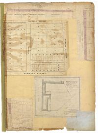
Page 13 of the City Engineer's Plat Book with five plats. Plat 1 features plots on East Bay Street between Tradd Street and Broad Street (which is labelled in the top-left corner), including several wharfs. Plat 2 shows lots located between Archdale Street and King Street, including a plot belonging to the "German Lutheran Church." Plat 3 features a plot of land located on King Street. Plat 4 shows plots located on State Street between Market Street and Amen Street. Plat 5 features "Potters Field Public Cemetery," located near President Street and Congress Street.
Letter from Laura L. Wineman, director of the KKBE choir, to President of the Board, Charles H. Moise. Wineman discusses the incorporation of instrumental music with the choir's singing. She relates the music from the "Portuguese Minhag" and a German synagogue.
Page 141 of the City Engineer's Plat Book with four plats. Plat 1 features a lot and structures located between Lynch Steet and the Ashley River, near Broad Street. It also shows Comings Creek, a pond, and a lot labelled "Clark & Steinmeyer." Plat 2 shows lots and structures located near the intersection of College Street and Calhoun Street. Plat 3 shows a lot and structures in "the City of Charleston in Ward No. 9." Plat 4 shows lots on and near Society Street, between Meeting Street and King Street.
Page 148 of the City Engineer's Plat Book with two plats. Plat 1 shows lots and structures located on and near Calhoun Street, between Washington Street and the Cooper River. Plat two shows "Lots in the Village of Rikersville," including 21 acres of marshland, a canal, and a pond.
Page 149 of the City Engineer's Plat Book with one plat. The plat shows lots located between Meeting Street and King Street, including a stretch of railroad.
Page 15 of the City Engineer's Plat Book with three plats. Plat 1 features plots located between Rutledge Street and Smith Street, near the intersections with Queen Street. Plat 2 features a lot on the corner of Tradd Street and Savage Street. Plat 3 shows the intersection of Calhoun Street and Rutledge Avenue (also labelled as Rutledge Street) with proposed changes.
Page 158 of the City Engineer's Plat Book with four plats. Plat 1 shows lots located on South Street, near where it intersects with Hanover Street. Plat 2 shows lots located on and near Mill Street, near its intersections with Lucas Street and President Street, and shows a building labelled "Dead House" and a creek labeled as "leading to canal." Plat 3 shows lots and structures located on East Bay Street. Plat 4 shows South Bay Street and its intersections with Legare Street and King Street.
Page 159 of the City Engineer's Plat Book with five plats. Plat 1 shows lots and structures located on East Bay Street, between Hasell Street and Cumberland Street. Plat 2 features a lot located on King Street, between Hudson Street and Tobacco Street. Plat 3 shows lots located between State Street and East Bay Street, located near their intersections with Market Street. Plat 4 shows lots located along "Horlbecks Alley," between King Street and Meeting Street. Plat 5 shows lots located on Short Street, between Mazyck Street and Franklin Street.
Letter from David Henry Mordecai to his father regarding his travels. The letter discusses regret to have to leave Heidelberg, plans to travel around Europe, and receiving cigars sent from home.
A handwritten, eight-page letter from Sallie Lowndes to Susan Alston in which she laments the financial status of their families following the Civil War and worries for their futures.
Page 160 of the City Engineer's Plat Book with four plats. Plat 1 shows a stretch of Mazyck Street, near its intersections with Queen Street and Short Street. Plat 2 shows lots and structures located on and near Reid Street, between Drake Street and Bay Street. Plat 4 shows lots and structures located between Nassau Street and Meeting Street, and between Stewart Street and Johnson Street.
Page 162 of the City Engineer's Plat Book with three plats. Plat 1 shows land located near Payne Street with several streams. Plat 2 shows lots located in the Village of Hampstead, located near America Street. The plat also shows marshland and streams. Plat 3 has numerous tears and holes. Plat 4 shows lots and structures located between Meeting Street and Lynch Street.
Page 163 of the City Engineer's Plat Book with two plats. Plat 1 shows lots and structures located on Friend Street, near its intersections with Queen Street, Broad Street, and an unlabeled street. Plat 2 shows lots located on King Street, near where it intersects with Broad Street.
Page 229 of the City Engineer's Plat Book with two plats. Plat 1 features lots located on Queen Street, near its intersections with Mazyck Street, Friend Street, King Street, and Meeting Street. Plat 2 features lots located between Sans Souci Street and Simons Street, and between Rutledge Avenue and King Street.
Page 232 of the City Engineer's Plat Book with one plat. The plat shows lots and structures between East Bay Street and the Cooper River, and between Society Street and Vernon Street. The plat also shows Washington Street, Marsh Street, Concord Street, Vernon Street, and Wharf Street.
Page 222 of the City Engineer's Plat Book with two plats. Plat 1 shows lots and structures located along East Bay Street, between Hasell Street and an unlabeled street. Plat 1 also shows Pritchard Street, Pinckney Street, Guignard Street, and Market Street. Plat 2 shows lots and structures located between Church Street and land owned by the Dry Dock Company. Plat 2 also shows Hayne Street, Anson Street, Guignard Street, and East Bay Street.
Page 220 of the City Engineer's Plat Book with one plat. The plat shows lots extending from the Ashley River, past Lucas Street. The plat also shows Doughty Street, Calhoun Street, President Street, U. S. Arsenal Square, and several structures.
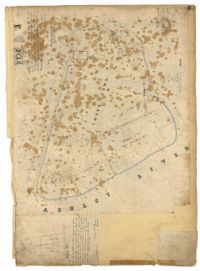
Page 216 of the City Engineer's Plat Book with one plat. Plat 1 shows lots and structures located east of the Ashley River, near Gadsden Street, Beaufain Street, and Wentworth Street.
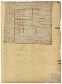
Page 205 of the City Engineer's Plat Book with two plats. Plat 1 shows "Lots in the Village of Rikersville," and shows Mechanics Street, 21 acres of marsh, a building labelled "Car Factory," a building labelled "Machinery," a building labelled "Wheat Mill," a canal, and a pond. Plat 2 shows lots and structures located between Pinckney Street and Market Street. Plat 2 also shows Hayne Street, Guignard Street, Church Street, Anson Street, Rafer's Alley, East Bay Street, a building labelled "Cotton Press," a park, and a building labelled "The Market."
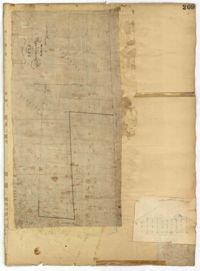
Page 209 of the City Engineer's Plat Book with one plat. The plat shows lots on and near Smith Street, between Radcliffe Street and Vanderhorst Street.
Page 189 of the City Engineer's Plat Book with three plats. Plat 1 shows lots between Moultrie Street and Huger Street, near where they intersect with King Street. Plat 2 shows lots located between Huger Street and Pinckney Street, near King Street. Plat 3 features a lot and budlings on Line Street.
Page 188 of the City Engineer's Plat Book with one plat. The plat shows lots located between Chesnut Street and President Street, and between Bee Street and a creek. It also shows Spring Street.
Page 171 of the City Engineer's Plat Book with three plats. Plat 1 shows lots located on and near the intersection of Meeting Street and Mt. Pleasant Street. Plat 2 shows lots located along King Street, near its intersection with Mt. Pleasant Street. Plat 3 shows the intersection of Calhoun Street and Smith Street.
Page 92 of the City Engineer's Plat Book with six plats. Plat 1 features a "Plan of the Citadel Square," located between King Street and Meeting Street, and between Calhoun Street and Hudson Street. Plat 1 also shows several buildings, including the Citadel, the "U.S. Gov. Stables," and the "U.S. Hospital." Plat 2 shows lots and several buildings located between Smith Street and Franklin Street. Plat 3 shows lots and structures located along Market Street, between Church Street and Meeting Street. Plat 4 shows lots and structures located near Calhoun Street. Plat 5 shows several lots and structures located on King Street. Plat 6 is affixed to the page so it folds out, and shows lots located near Spring Street, between Chesnut Street and President Street. Plat 6 also shows Pine Street, Cannons Court, and Bee Street.
Page 90 of the City Engineer's Plat Book with four plats. Plat 1 shows lots located between King Street and Russell Street, near Grove Street and Poinsett Street. Plat 2 shows lots located between Meeting Street and King Street, with a strip of land labelled "S.C.R.R.," a common acronym for the South Carolina Rail Road. Plat 3 features lots located near Boigard Street. Plat 4 features land located on the Ashley River, near Grove Street, shows a stream and several structures.
Page 91 of the City Engineer's Plat Book with five plats. Plat 1 shows lots located near Guinard Street. Plat 2 shows lots located between Nassau Street and Meeting Street, and between Johnson Street and Stuart Street. Plat 3 shows lots located along East Bay Street, between Guignard Street and Pinckney Street. Plat 4 features a lot and several structures located near the intersection of Logan Street and Broad Street. Plat 5 features a lot located near the intersection of Broad Street and Rose Lane.
Page 93 of the City Engineer's Plat Book with two plats. Plat 1 features the "U.S. Custom-House Premises," located between East Bay Street and the Cooper River, and Market Street and Gaillard Street. Plat 1 also shows several structures. Plat 2 features a lot near "Smith's Place" and a creek, and shows several structures, including one labelled "Saw and Planning Mill" and another labelled "Engine Boiler room."
Page 77 of the City Engineer's Plat Book with seven plats, labelled 1 through 8 with Plat 3 missing. Plat 1 shows lots located between Smith Street and King Street, and between Morris Street and Radcliffe Street. Plat 1 also shows Coming Street and St. Philips Street, and a label reading "Bethlohim Congregation." Plat 2 shows lots and some structures near the intersection of King Street and Warren Street. Plat 4 shows lots between Smith Street and King Street, and north of Radcliffe Street. Plat 4 also shows Coming Street, St. Philips Street, Morris Street, and a lot labelled "Bethlehem Congregation." Plat 5 shows lots located near the intersection of Morris Street and St. Philips Street. Plat 6 shows lots located between Morris Street and "Hunter St now Line," and east of Coming Street. Plat 8 features a lot and structures located on the corner of St. Philips Street and Morris Street.
Page 83 of the City Engineer's Plat Book with eight plats. Plat 1 shows lots and some buildings located near Amherst Street, between Hanover Street and Nassau Street. Plat 2 shows lots located near the intersection of Mary Street and America Street, including a lot with structures including stables, a coach house, and a kitchen. Plat 3 shows lots located on Bay Street, near its intersections with North Street, Cooper Street, Drake Street, and Columbus Street. Plat 4 shows lots located along Drake Street, between Reid Street and Amherst Street. Plat 5 shows lots located on Meeting Street and Line Street. Plat 6 shows lots located near Line Street, between Meeting Street and Nassau Street. Plat 7 shows lots located near the intersection of Meeting Street and Columbus Street, and also shows a small Stretch of Spring Street. Plat 8 shows lots along Line Street, between Meeting Street and Aiken Street.
Page 79 of the City Engineer's Plat Book with six plats. Plat 1 shows a lots and some structures located between Doughty Street and Palmetto Street, and also shows Ashley Street and a structure labelled "United States Arsenal Wall." Plat 2 shows lots located near the intersection of Bee Street and President Street. Plat 3 shows lots located on Doughty Street, between Ashley Street and Rutledge Street. Plat 4 features lots and land located near the intersection of Bee Street and President Street. The plat also shows a mill pond and several structures. Plat 5 shows lots located between Doughty Street and Mill Street, and near Ashley Street. Plat 5 also shows Palmetto Street and a lot labelled U. S. Arsenal. Plat 6 shows lots located between Thomas Street and Pinckney Street, with several structures.
Page 82 of the City Engineer's Plat Book with five plats. Plat 1 shows lots located near the intersection of King Street with Sheppard Street. Plat 2 shows lots surrounding Hampstead Mall, between Bay Street and Meeting Street, and between Bull Street and South Street. Plat 2 also shows America Street, Amherst Street, Columbus Street, and a lot labelled "Medical Society." Plat 3 shows lots located on or near Spring Street, between King Street and Meeting Street. Plat 4 features lots near Hampstead Mall, near America Street, Aiken Street, and Columbus Street. Plat 5 features lots located on and near Meeting Street, between Woolfe Street and Columbus Street. Plat 5 also shows Nassau Street and a lot labelled "Tevole Garden."
Page 84 of the City Engineer's Plat Book with five plats. Plat 1 shows lots located near Meeting Street, between Sheppard Street and Line Street. Plat 2 shows lots located along Race Street, between Rutledge Street and King Street. Plat 3 shows lots located between King Street and Meeting Street, and shows a stretch of Russell Street. Plat 4 features a lot and several buildings located near the intersection of Line Street and Meeting Street. Plat 4 also shows a label reading "The Rail Road" and another reading "Rail Road Company." Plat 5 features a lot on Hanover Street, and also shows a lot labelled "Cemetery."
Page 85 of the City Engineer's Plat Book with three plats. Plat 1 shows the "Village of Hampstead," between Boundary Street and Mary Street, and between King Street and the Cooper River. The plat also shows City Lands, stretches of March, a stream, Wragg Square, the Mall, and Mazyckborough. Other streets shown include Washington Street, Alexander Street, Chapel Street, and Meeting Street. Plat 2 shows a similar stretch as Plat 1, but with different boundary lines for the lots. Plat 3 shows lots and structures located near King Street.
Page 80 of the City Engineer's Plat Book with one plat. The plat shows a plan for developing a stretch of land from the Ashley River towards President Street and Lucas Street, with a few lots and structures further east. The plat also shows a lot labelled "U. S. Arsenal Square," and a mill on the Ashley River.
Page 71 of the City Engineer's Plat Book with eight plats. Plat 1 shows lots and structures on a city block between Rutledge Street and Smith Street, and between Beaufain Street and Wentworth Street. Plat 2 shows lots located near the intersection of Moore Street and Meeting Street. Plat 3 shows lots and structures located near the intersection of King Street and Beaufain Street. Plat 4 shows lots and structures located on the east side of Coming Street. Plat 5 shows lots located on King Street, including a lot labelled "Unitarian Church property" and a stretch labelled "Unitarian Church Cemetery." Plat 6 shows lots located on King Street, and shows the "Old line of street." Plat 7 shows plots located on King Street. Plat 8 features a lot and buildings located on Spring Street, and shows how Rosemont Street is projected to cross that property.
Page 73 of the City Engineer's Plat Book with six plats. Plat 1 shows lots and some buildings located near the intersection of Chapel Street and Alexander Street. Plat 2 shows lots located near King Street's intersections with Radcliffe Street, Vanderhorst Street, Hutson Street, John Street, and Ann Street. The plat also shows Meeting Street, the Mall, and a body of water. Plat 3 shows lots, structures, and marshland located near the intersection of Coming Street and Smith Street. Plat 4 shows lots and some buildings located near John Street, between King Street and a some "Rail Road Land." Plat 5 shows lots located near King Street, between Tobacco Street and Calhoun Street. Plat 6 features a stretch of land between King Street and Meeting Street, along John Street's north side and near Radcliffe Street. The plat also shows a feature labelled "Ravine."
Page 75 of the City Engineer's Plat Book with six plats. Plat 1 features lots located between Radcliffe Street and Calhoun Street, and between Smith Street and Rutledge Street. Plat 1 also shows Vanderhorst Street, Thomas Street, and Warren Street. Plat 2 shows lots located near Morris Street, between St. Philips Street and Coming Street. Plat 3 shows lots located near the intersection of Morris Street and Coming Street, including a lot labelled "Cemetery" and another lot labelled "Hebrew Cemetery." Plat 4 shows land located near Thomas Street, between Doughty Street and Hutson Street, and also labels a pond. Plat 5 shows lots located between Pine Street and Gadsden Creek. Plat 6 shows lots and some buildings located between Pinckney Street and Smith Street.
Page 68 of the City Engineer's Plat Book with eight plats. Plat 1 shows lots and some structures located near the intersection of Rutledge and Wentworth Street. Plat 2 features lots and some structures located near Bull Street, between Lynch Street and Gadsden Street, and has a label reading "Mill Pond." Plat 3 shows lots and buildings located near the intersection of Bull Street and Lynch Street. Plat 4 shows a city block between Wentworth Street and Beaufain Street, and Smith Street and Rutledge Street. Plat 5 shows lots located on Beaufain Street. Plat 6 features a lot located on "Comings Street," between Wentworth Street and Montague Street. Plat 7 shows a city block located between Wentworth Street and Montague Street, and Gadsden and Lynch Street. Plat 8 shows a city block located between Lynch Street and Rutledge Street, and Wentworth Street and Beaufain Street.
Page 74 of the City Engineer's Plat Book with four plats. Plat 1 shows lots and some buildings located near Line Street, between King Street and a "Rail Road Company Road." Plat 2 shows lots located along Amherst Street, including one labelled "Cemetery of the Evangelical German Lutheran Church." Plat 3 shows land located between Washington Street and the Charleston Harbor, and includes several structures, a pond, docks, a wharf, and a canal. Plat 4 shows lots and some structures located near the intersection of Smith Street and Calhoun Street.
Page 62 of the City Engineer's Plat Book with eight plats. Plat 1 shows lots located near East Bay Street. Plat 2 shows a lot on Concord Street, including a wharf. Plat 3 shows three Wharf Lots on Wharf Street, near the intersection with Inspection Street. Plat 4 features a lot on Wharf Street with a dock and a brick building, across the street from a building labelled "Eagle Foundry." Plat 5 shows a lot with several buildings on East Bay Street. Plat 6 shows land near the intersection of East Bay Street and Cumberland Street, with a stretch labelled "Passage to what is now called Central Wharves." Plat 7 shows a wharf and yard on Concord Street, and a structure labelled "Cotton Shed on Brick Pillars." Plat 8 shows a lot located at the intersection of Anson Street and Calhoun Street.
1862, 1885, 1850, 1815, 1866, 1873, 1830, 1833, and 1787
Description:
Page 60 of the City Engineer's Plat Book with eight plats. Plat 1 shows lots near East Bay Street, and the intersection of Washington Street and Inspection Street. Plat 2 shows lots and a building located near Market Street. Plat 3 shows lots located between Washington Street and Marsh Street, and between Inspection Street and Calhoun Street. Plat 4 shows plots located on Market Street with a dotted line labeled "Line of Street proposed by the City." Plat 5 shows plots and structures located near East Bay Street. Plat 6 shows lots located near the intersection of Concord Street and Inspection Street. Plat 7 shows lots located near the intersection of Pinckney Street and East Bay Street. Plat 8 shows a dock and wharf on the Cooper River.
Page 63 of the City Engineer's Plat Book with five plats. Plat 1 features wharves located near East Bay Street, and shows several docks and buildings. Plat 2 shows wharfs shows a wharf and several buildings located near East Bay Street. Plat 3 features a wharf located near East Bay Street and shows multiple buildings and docks. Plat 4 features a wharf located between East Bay Street and the Cooper River channel, and also shows several buildings. Plat 5 shows lots located on and near Market Street, between East Bay and Concord Street. Plat 6 features a wharf located between East Bay Street and the Cooper River, and also shows several buildings.
Page 61 of the City Engineer's Plat Book with four plats. Plat 1 features a lot and buildings located between East Bay Street and Concord Street, and between Pritchard Street and Hasell Street. Plat 2 shows lots between Pritchard Street and Hard Alley, near their intersections with East Bay Street. Plat 3 shows lots located on Pritchard Street, between East Bay Street and Concord Street, with some buildings labelled. Plat 4 shows lots located near the intersection of Meeting Street and Queen Street with some buildings and structures labelled.
Page 67 of the City Engineer's Plat Book with two plats. Plat 1 features three lots located on Meeting Street, with stores and yards labelled. Plat 2 shows a stretch of land near the Ashley River, and the intersection of Calhoun and Lucas Street. Plat 2 also shows a large building labelled "West Point Rice Mill" and a stretch labelled "Mill Pond."
Page 57 of the City Engineer's Plat Book with seven plats. Plat 1 shows buildings, wharves, and docks located near South Bay Street. Plat 2 shows lots located near the intersection of Church Street and Chalmer Street, including buildings labelled "Stable," "Kitchen," and "Carolina Hotel." Plat 3 features a lot and several buildings located near Broad Street. Plat 4 features a lot and buildings located on Broad Street. Plat 5 shows lots located near the intersection of Broad Street and Rutledge Street. Plat 6 shows lots located between Broad Street and "St. Michaels Alley." The last plat shows lots on East Bay Street, between Pinckney Street and Hasell Street.
Page 56 of the City Engineer's Plat Book with seven plats. Plat 1 shows lots between Savage Street and Tradd Street. Plat 2 shows lots and some buildings on South Bay Street. Plat 3 shows lots between Savage Street and Broad Street. Plat 4 shows a lot and several buildings at the intersection of Friend and Queen Street. Plat 5 shows land near the corner of Legare Street and Gibbes Street, and a few buildings. Plat 6 shows a lot on the west side of Friend Street. Plat 7 shows lots located between Broad Street and Tradd Street, and between Lynch Street and the Ashley River.
Page 53 of the City Engineer's Plat Book with five plats. Plat 1 shows shoals and marshlands located near the Ashley River Channel, Gibbes Street, and South Bay Street. Plat 2 features a lot and its buildings at the intersection of Broad Street and New Street. Plat 3 shows a lots and buildings located on Tradd Street. Plat 4 features lots and buildings located near the intersection of Broad Street and Tradd Street, including some stretches of marshland. Plat 5 shows lots located near Broad Street's and Tradd Street's intersections with New Street and Legare Street.
Page 55 of the City Engineer's Plat Book with five plats. Plat 1 shows lots near the intersection of Broad Street and Queen Street. Plat 2 shows lots and some buildings on Broad Street. Plat 3 shows land and buildings between Broad Street and Short Street, near their intersections with Mazyck Street. Plat 4 shows lots near Broad Street, Franklin Street, and Trapman Street. Plat 5 shows lots between Broad Street and Short Street, near their intersections Mayzck Street.
Page 47 of the City Engineer's Plat Book with four plats. Plat 1 shows lots between America Street and Meeting Street, and between Moultrie Street and Line Street. Plat 1 also includes a stretch of Moultrie Street and Hampton Street extending from Meeting Street to King Street. Plat 2 shows the plan of a wharf and channel located on East Bay Street, and includes several planned buildings and structures. Plat 3 shows lots of land located between East Bay Street and the "Edge of Channel of Cooper Street." Plat 4 shows lots located near East Bay Street's intersections with Water Street and Lynches Lane. Plat 4 shows several buildings, "Flat Broken ground," low lands, and a "Shoal dry at Low Water."
Page 46 of the City Engineer's Plat Book with five plats. Plat 1 shows lots on Butler Street, between Russell Street and Meeting Street. Plat 2 shows marshland and lots located near Huger Street and "Congress alias Pinckney Street." Plat 3 shows lots located near the intersection of "Rutledge formerly Congress Street" and Huger Street, and also shows Moultrie Street, Pinckney Street, and Legare Street. Plat 4 shows land near the intersection of King Street and Queen Street and several buildings. Plat 5 shows lots between "Hunter now Line" Street, and "Elliot St. now Spring St.," and also shows Rutledge Avenue and Boigard Street.
Page 48 of the City Engineer's Plat Book with five plats. Plat 1 shows lots located between Smith Street and King Street, and Radcliffe Street and Vanderhorst Street, including stretches of Thomas Street, Coming Street, St. Philip Street, and King Street. Plat 2 shows lots and buildings located near the intersection of King Street and South Bay Street. Plat 3 shows land near the intersection between Congress Street and Legare Street, and includes stretches of Hayne Street, Mount Street, and President Street. Plat 3 also shows some land labelled "City Land Potters Field." Plat 4 shows lots and a set of buildings located near Broad Street and Savage Street. Plat 5 shows lots and some buildings located on Gadsden Street.
Page 42 of the City Engineer's Plat Book with five plats. Plat 1 shows land between King Street and the Ashley River, and shows bodies of water. Plat 2 shows land between Tradd Street and Payne Street, and several buildings. Plat 3 shows land and buildings on Cumberland Street, and shows two cemeteries, "Cemetery of the Circular Church," and "St Philip's Cemetery." Plat 4 shows plots near the intersection of Henrietta Street and Elizabeth Street. Plat 5 shows lots between "Marsh Street" and "Back Street."
Page 43 of the City Engineer's Plat Book with two plats. Plat 1 shows lots near Jasper Street, Smith Street, Marion Street, and Radcliffe Street. Plat 2 shows lots between Back Street and Marsh Street, and Magazine Street and Queen Street.
Page 33 of the City Engineer's Plat Book with five plats. Plat 1 shows land located near Mount Street's intersections with "Payne late Legare Street," Larne Court, and "Rutledge late Pinckney Street," including a stretch labelled "Flat Land." Plat 2 shows lots located near the intersection of Beaufain Street and King Street. Plat 3 shows lots located on "Council or New Street," near Gibbes Street, Smith Street, Beaufain Street, Tradd Street, New Street, and Savage Street. Plat 4 shows lots located along South Bay Street, between King Street and Meeting Street. Plat 5 shows lots, buildings, and structures located near the intersection of Line Street and Nassau Street.
Page 39 of the City Engineer's Plat Book with five plats. Plat 1 shows lots and some buildings along East Bay Street, between the intersections with Hassell Street and Cumberland Street. Plat 2 shows lots and some buildings located between Line Street and Shepherd Street. Plat 3 shows lots located between Queen Street and Magazine Street. Plat 4 features a lot and its buildings on King Street. Plat 5 features a lot at the intersection of East Bay Street and Rose Lane.
Page 40 of the City Engineer's Plat Book with three plats. Plat 1 shows lots located between Laurence Street and Boundary Street, and Anson Street and the Charleston Harbor on the Cooper River. Plat 1 also shows East Bay Street, Washington Street, Concord Street, several wharfs, marshland, and a label reading "Mazyck Borough." Plat 2 shows lots on Simmons Street, between King Street and a stretch of marshland. Plat 3 shows lots of land between New Street and Logan Street, and several buildings.
Page 36 of the City Engineer's Plat Book with three plats. Plat 1 shows land located near President Street and Rutledge Avenue, and labels certain marshlands and bodies of water. Plat 2 shows lots located near the intersection of King Street and Grove Street, near Milligan Street. Plat 3 shows land and buildings located near the intersection of Pitt Street and Bull Street.
Page 38 of the City Engineer's Plat Book with two plats. Plat 1 shows lots located near Calhoun Street, some buildings, "Lots Belonging to Sundry Persons," and "The Mall." Plat 1 also shows Bennett Street, Ashley Street, Rutledge Street, Gadsden Street, and Lynch Street. Plat 2 features a lot on Smith Street.
Page 37 of the City Engineer's Plat Book with three plats. Plat 1 shows lots located on Herriot Street. Plat 2 shows lots located on the block between Rutledge Street and Smith Street, and Morris Street and Radcliffe Street. Plat 3 shows lots and buildings located on King Street, with a stretch labelled "Unitarian Church Land."
Page 29 of the City Engineer's Plat Book with three plats. Plat 1 shows lots and structures located near Calhoun Street, Rutledge Street, Lynch Street, Gadsden Street, Lucas Street, and Bennett Street, including a lot labelled "Public Square," a creek, and a building labelled "Saw Mill." Plat 2 shows land located near the intersection of West Bay Street and a body of water labelled "Mill Pond." Plat 3 shows land located near the Ashley River channel and a road labelled "Causeway Leading to Rice Mill."
Page 28 of the City Engineer's Plat Book with three plats. Plat 1 shows lots located near Calhoun Street, Bull Street, South Street, Ashley Street, Rutledge Street Lynch Street, and Bennett Street. Plat 1 also shows lots labelled "The Mall," and Lots Belonging to Sundry Persons. Plat 2 shows lots and buildings located near the intersection of Calhoun Street and Lucas Street, including lots labelled "Mansion Lot" and "Left for a Public Square." Plat 3 shows lots and buildings located near Bee Street, between Ashley Street and Rutledge Street.
Page 27 of the City Engineer's Plat Book with five plats. Plat 1 shows lots located on Broad Street, between the intersections with East Bay Street and State Street. Plat 2 shows lots on Chapel Street. Plat 3 shows lots near Savage Street and Tradd Street. Plat 4 shows lots on Savage Street. Plat 5 shows lots near the intersection of Broad Street and East Bay Street.
Page 25 of the City Engineer's Plat Book with two plats. Plat 1 shows lots and buildings near Guignard Street, located between East Bay Street and "Rapers Ally." Plat 2 shows lots located near Cumming Street, between Shepherd Street and Line Street.
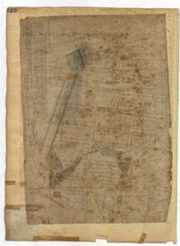
Page 30 of the City Engineer's Plat Book with one plat. The plat features the West Point Rice Mill on the Ashley River Channel. It shows numerous buildings and structures, a creek, and the nearby Bull Street, Montague Street, Barre Street, and Gadsden Street.
Page 31 of the City Engineer's Plat Book with two plats. Plat 1 shows lots located along a private street, between Mount Street and Congress Street. Plat 2 features lots located between Payne Street and Rutledge Street.
Page 21 of the City Engineer's Plat Book with six plats. Plat 1 shows land between Broad Street and Tradd Street, and Logan Street and New Street, including a sizable portion labelled "Middletons Lots." Plat 2 shows a lot on Broad Street and its buildings. Plat 3 shows lots located near Rutledge Street, Queen Street, Beaufain Street, and Smith Street, and some "City marshlands." Plat 4 shows plots located near Rutledge Street, Beaufain Street, Queen Street, and Smith Street. Plat 5 shows a lot and buildings located near the intersection of Queen Street and Mazyck Street. Plat 6 shows lots of land located on King Street, including one labelled "Unitarian Church."
Page 22 of the City Engineer's Plat Book with five plats. Plat 1 shows lots located near the Charleston Harbor, Concord Street, Pinckney Street, and Pritchard Street. Plat 2 shows lots and structures located near the intersection of Concord Street and Pinckney Street, including a single-story building, a wharf, and a label reading "City property leased." Plat 3 shows a lot on Broad Street labelled "Lot of David McCredie." Plat 4 Shows lots located near Park Street, and between Shepherd Street and Line Street. Plat 5 shows lots near the intersection of Broad Street and Gadsden's Alley labelled with the names of banks.
Page 17 of the City Engineer's Plat Book with five plats. Plat 1 shows plots of land located on Logan Street. Plat 2 shows land on East Bay Street. Plat 3 shows a plot of land on the corner of East Bay Street and Gibbes Street. Plat 4 shows the "Old Exchange" located at the intersection of East Bay Street and Broad Street. Plat 5 shows lots located on East Bay Street between the intersections with Cumberland Street and Market Street, including a larger lot labelled "New Custom House Lot."
Page 20 of the City Engineer's Plat Book with two plats. Plat 1 shows lots and buildings located near the Cooper River, Warf Street, and Concord Street, including a rice mill and a lot labelled "Atlantic Steam Packet Company." Plat 2 shows a city block between State Street and East Bay Street, and Market Street and Cumberland Street.
Page 18 of the City Engineer's Plat Book with two plats. Plat 1 shows lots located near King Street, Moultrieville Street, and Huger Street. Plat 2 shows lots located near the Cooper River, Charlotte Street, and Washington Street.
Page 7 of the City Engineer's Plat Book with four plats. Plat 1 shows lots on Bay Street. Plat 2 features plots on Hanover Street near the intersection with Reid Street and shows a lot labelled "African Burial Ground." Plat 3 features lots between Payne Street and Rutledge Street, near Fishburne Street and Market Street. Plat 4 shows lots and buildings near the intersection King Street and Broad Street. Plat 5 features lots on Cumberland Street.
Page 5 of the City Engineer's Plat Book with three plats. Plat 1 shows plots near Meeting Street, Russell Street, King Street, and a creek labelled "Small Creek." Plat 2 shows plots of land near the intersection of Water Street and Church Street. Plat 3 shows Calhoun Street where it intersects with Ashley Street and Lynch Street, and shows a lot labeled "St. Xavier's Infirmary."
Page 6 of the City Engineer's Plat Book with three plats. Plat 1 shows a lot on the Ashley River. Plat 2 shows lots on Friend Street located between Broad Street and Tradd Street. Plat 3 features lots on King Street and includes a lot labeled "Orphan House Lot."
Page 9 of the City Engineer's Plat Book with four plats. Plat 1 shows lots near the intersection of Cannon Street and Smith Street. Plat 2 features plots of land and buildings located near Savage Street. Plat 3 shows plots of land located near the intersection of Queen Street and Rutledge Street. Plat 4 features lots on Simons Street.
Page 8 of the City Engineer's Plat Book with two plats. Plat 1 shows plots near "Village Hampstead Public Square" and shows numerous streets including King Street, Columbus Street, and Meeting Street. Plat 2 shows lots near the intersection of Radcliffe Street and King Street, including a lot labelled "Estate of McIntosh."
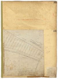
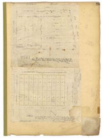
Page 2 of the City Engineer's Plat Book with five plats. Plat 1 shows the intersections of Guignard Street with East Bay Street and "Raper's Alley," and features a building labelled "Old Mansion Ruins." Plat 2 shows the intersection of East Bay Street and Market Street near the "Charleston Harbour on the Cooper River," and features plans to expand Market Street. Plat 3 features a stretch of land from the end of Rose Alley to the Cooper River, labelled as "Union Warf No. 1." Plat 4 features the same stretch of land as Plat 2 with slightly more land to the north. Plat 5 features the intersections of Tradd Street with Legare Street and Friend Street.
Page 4 of the City Engineer's Plat Book with seven plats. Plat 1 features East Bay Street, Pinckney Street, Concord Street, and lots labelled "Burnt District." Plat 2 features lots on King Street. Plat 3 shows several lots on East Bay Street near the intersections with Pritchard Street and Hard Alley. Plat 4 shows three lots on East Bay Street. Plat 5 features lots at the intersection of East Bay Street and Hasell Street. Plat 5 shows a stretch of Queen Street including the intersections with Archdale Street and Friend Street, and includes a plat labelled "Catholic Church." Plat 7 shows plots of land on the intersection of Tradd Street and Meeting Street.
Page 3 of the City Engineer's Plat Book with four plats. Plat 1 features lots at the intersection of Laurens Street and East Bay Street, and labels a section of salt marsh. Plat 2 shows plots at the intersection of East Bay Street and Hasell Street. Plat 3 features three lots of land and buildings on East Bay Street. Plat 4 shows a stretch of Pinckney Street between Bay Street and the Cooper River, including several lots.
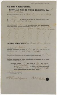
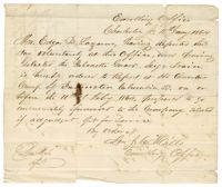
Letter from the enrolling office of Charleston, SC, stating Edgar M. Lazarus voluntarily reported to the enrollment office and chose to report to the Palmetto Guard Siege Train. The Letter also states that Lazarus is to report to the Camp of Instruction in Columbia, SC and then on to the company he had selected.
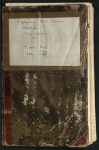
Meeting minutes volume kept by the Kahal Kadosh Beth Elohim Board of Trustees, 1846-1852. The entries in this volume concern all discussions regarding synagogue business, finances, memberships, the search for a new minister, and the beginnings of Reform Judaism within the congregation. The entries also include notes on Reverend Gustavus Poznanski and his thoughts on the Reform.
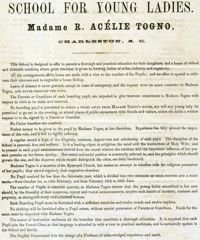
Printed broadside includes description of curriculum, rules of conduct, tuition and refereces. Madame Rosalie Acelie Togno opened her french and english boarding school for young ladies in Charleston under the patronage of James Louis Petigru in 1854. Initially located on Tradd Street, the school and dormitory for students was relocated to Meeting Street soon after. Togno was a fluent speaker of french and arrived in Charleston by way of New York. Her strict teaching style set new standards for education in antebellum Charleston and students were instructed in science, history, geograph and writing . Madame Togno's students included such notable women as Adele Allston Vanderhorst and Elizabeth Allston Waties Pringle. During the Civil War, Togno relocated her school to Barhamville, South Carolina but was forced to flee South Carolina soon after.