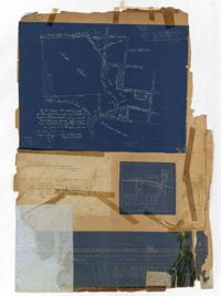
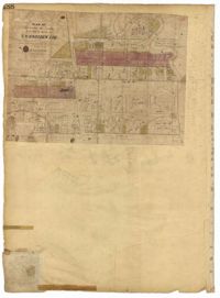
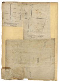
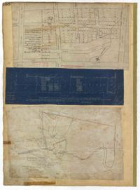
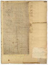
Page 122 of the City Engineer's Plat Book with three plats. Plat 1 shows lots and structures on Meeting Street. Plat 2 shows lots and structures located near the intersection of Anson Street and Laurens Street. Plat 3 shows lots located between Moultrie Street and Huger Street, near Rutledge Avenue.
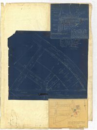
Page 124 of the City Engineer's Plat Book with one plat. The plat features several lots and structures located on and near King Street, with one labelled "Theatre Lot."
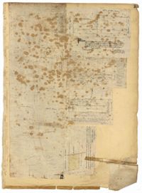
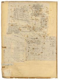
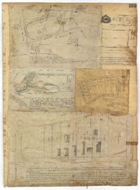
Page 45 of the City Engineer's Plat Book with nine plats. Plat 1 shows lots along New Street, located between Broad Street and Tradd Street, and shows an area labelled "City marshland." Plat 2 shows lots and buildings located between Queen Street and Cliffords Alley. Plat 3 shows land located near the intersection of Washington Street and Smith Street. Plat 4 shows lots and buildings located near the intersection of Green Street and "Comming Street." Plat 5 shows land located between "Boundary (Calhoun) Street" and George Street, and St. Phillip Street and "Comming Street," including a stretch of Green Street and College Street, and a lot labelled "College Lot." Plat 6 shows a lot located on the corner of Queen Street and King Street, and its buildings. Plat 7 shows lots located on Savage Street. Plat 8 shows lots located on Beaufain Street. Plat 9 shows lots near King Street, located between Boulevard Drive and South Bay Street.
Page 41 of the City Engineer's Plat Book with six plats. Plat 1 shows land between Mount Street and Congress Street, and between a private street and "CITY LANDS Potter's Field." Plat 2 shows lots near Chestnut Street and near Spring Street, Ashton Street, Always Street, Lilly Street, and Pine Street. It also shows a few bodies of water. Plat 3 shows lots near Meeting Street's intersections with Market Alley, and State House Alley. It also labels a court house, the Treasury and Guard House, and St. Michael's Church. Plat 4 shows a stretch of land near President Street, Logan Street, Pinckney Street, Fishburne Street, Mount Street, Congress Street, and shows bodies of water and highlands. Plat 5 shows lots and buildings near the intersection Church Street and Water Street.
Page 47 of the City Engineer's Plat Book with four plats. Plat 1 shows lots between America Street and Meeting Street, and between Moultrie Street and Line Street. Plat 1 also includes a stretch of Moultrie Street and Hampton Street extending from Meeting Street to King Street. Plat 2 shows the plan of a wharf and channel located on East Bay Street, and includes several planned buildings and structures. Plat 3 shows lots of land located between East Bay Street and the "Edge of Channel of Cooper Street." Plat 4 shows lots located near East Bay Street's intersections with Water Street and Lynches Lane. Plat 4 shows several buildings, "Flat Broken ground," low lands, and a "Shoal dry at Low Water."
Page 49 of the City Engineer's Plat Book with six plats. Plat 1 shows land on the Cooper River. Plat 2 shows land located near Broad Street's intersections with Gadsden Street and Lynch Street, and a stream labelled "Comings Creek." Plat 3 shows wharfs and buildings along the Cooper River and near Champney Street. Plat 4 shows wharves and other structures between East Bay Street and the Cooper River. Plat 5 shows land near South Bay Street's intersections with Meeting Street and Church Street, including a lot labelled "Battery Garden" and a structure labelled "Bathing House."
Page 46 of the City Engineer's Plat Book with five plats. Plat 1 shows lots on Butler Street, between Russell Street and Meeting Street. Plat 2 shows marshland and lots located near Huger Street and "Congress alias Pinckney Street." Plat 3 shows lots located near the intersection of "Rutledge formerly Congress Street" and Huger Street, and also shows Moultrie Street, Pinckney Street, and Legare Street. Plat 4 shows land near the intersection of King Street and Queen Street and several buildings. Plat 5 shows lots between "Hunter now Line" Street, and "Elliot St. now Spring St.," and also shows Rutledge Avenue and Boigard Street.
Page 48 of the City Engineer's Plat Book with five plats. Plat 1 shows lots located between Smith Street and King Street, and Radcliffe Street and Vanderhorst Street, including stretches of Thomas Street, Coming Street, St. Philip Street, and King Street. Plat 2 shows lots and buildings located near the intersection of King Street and South Bay Street. Plat 3 shows land near the intersection between Congress Street and Legare Street, and includes stretches of Hayne Street, Mount Street, and President Street. Plat 3 also shows some land labelled "City Land Potters Field." Plat 4 shows lots and a set of buildings located near Broad Street and Savage Street. Plat 5 shows lots and some buildings located on Gadsden Street.
Page 50 of the City Engineer's Plat Book with seven plats. Plat 1 shows wharves and other structures located on East Bay Street. Plat 2 shows lots and buildings located on the intersection of Tradd Street and Meeting Street. Plat 3 shows lots located near the intersection of Broad Street and Rutledge Street. Plat 4 shows lots and buildings located near Gibbes Street. Plat 5 shows lots located near the intersection of Society Street and East Bay Street. Plat 6 shows lots and buildings near Broad Street. Plat 7 shows lots located between South Bay Street and the Ashley River, near Legare Street.
Page 53 of the City Engineer's Plat Book with five plats. Plat 1 shows shoals and marshlands located near the Ashley River Channel, Gibbes Street, and South Bay Street. Plat 2 features a lot and its buildings at the intersection of Broad Street and New Street. Plat 3 shows a lots and buildings located on Tradd Street. Plat 4 features lots and buildings located near the intersection of Broad Street and Tradd Street, including some stretches of marshland. Plat 5 shows lots located near Broad Street's and Tradd Street's intersections with New Street and Legare Street.
Page 55 of the City Engineer's Plat Book with five plats. Plat 1 shows lots near the intersection of Broad Street and Queen Street. Plat 2 shows lots and some buildings on Broad Street. Plat 3 shows land and buildings between Broad Street and Short Street, near their intersections with Mazyck Street. Plat 4 shows lots near Broad Street, Franklin Street, and Trapman Street. Plat 5 shows lots between Broad Street and Short Street, near their intersections Mayzck Street.
Page 256 of the City Engineer's Plat Book with four plats. Plat 1 shows land located between Elliot Street and Boundary Street, near Mill Street, Bee Street, President Street, and Doughty Street. It also shows several streams, a mill pond, and a large stretch of marsh land. Plat 2 shows a lot on Brigade Street. The third plat shows a lot and building located on the corner of Grove Street and Russell Street. The fourth plat shows lots located near the intersection of Grove Street and Tracy Street.
Page 259 of the City Engineer's Plat Book with three plats. Plat 1 shows lots located between Hester Street and Piedmont Street. Plat 1 also shows Alberta Street, Poplar Street, and a stretch of marsh land. Plat 2 shows lots located between Tradd Street, Ashley Street, and Murray Boulevard. Plat 2 also shows South Bay Street. Plat 3 shows a city block between Hester Street and Piedmont Avenue, and between Poplar Street and Alberta Avenue.
Page 248 of the City Engineer's Plat Book with two plats. Plat 1 shows lots and structures located between Wescott Court and President Street, north of Bee Street. Plat 2 shows lots on and near Huger Street, King Street, Congress Street, and Benson Street.
Page 252 of the City Engineer's Plat Book with two plats. Plat 1 shows lots on and near Lenwood Street, between South Bay Street and Boulevard Drive. Plat 2 shows lots located on and near the intersection of Huger Street and Rutledge Avenue.
Page 178 of the City Engineer's Plat Book with five plats. Plat 1 shows lots and structures located on and near King Street, near the intersection with "Shepheard" Street. Plat 2 shows lots located on and near Spring Street, King Street, and Meeting Street. Plat 3 shows lots and a building located near the intersection of King Street and Sheppard Street. Plat 4 shows lots located on a city block between Cooper Street and Lee Street, and between Aiken Street and America Street. One lot is labelled "Baptist Church Lot." Plat 5 shows Cooper Street, Aiken Street, Lee Street, and America Street.
Page 182 of the City Engineer's Plat Book with three plats. Plat 1 shows lots and structures located along Spring Street, near its intersection and Chesnut Street. Plat 2 shows "the Schützenplatz," located at the end of Heriot Street. It also shows several structures, a marsh extending to the Ashley River, and a label reading "Known as the Village of Rikersville." Plat 3 shows lots and low land located near Meeting Street.
Page 184 of the City Engineer's Plat Book with five plats. Plat 1 shows "a certain plantation" near a "Marsh of Ashley." Plat 2 features a lot located on Congress Street, with several structures and streams. Plat 3 shows lots and structures located on Chesnut Street. Plat 4 shows lots and structures located on and near King Street, near its intersections with Romney Court and Simons Street.
Page 183 of the City Engineer's Plat Book with five plats. Plat 1 shows lots located along Simons Street, between King Street and a stretch of marshland. Plat 2 shows lots on and near "Simmons" Street. It also shows lots near King Street and Romney Court. Plat 3 shows lots located near the intersection of King Street and Grove Street. Plat 4 shows lots and structures located near the intersection of Simons Street and King Street. Plat 5 shows lots along Simons Street, located between King Street and a stretch of marshland.
Page 185 of the City Engineer's Plat Book with four plats. Plat 1 shows lots and structures located near [Map too blurry to read, check when in-office]. Plat 2 shows lots and structures located near the intersection of Spring Street and Ashley Street. Plat 3 shows lots located near the intersection of Mount Street and Rutledge Avenue. Plat 4 shows lots located near Rutledge Avenue, between Congress Street and Huger Street.
Page 190 of the City Engineer's Plat Book with two plats. Plat 1 shows lots located along Addison's Court, between Meeting Street and a lot owned by the South Carolina Rail Road. Plat 2 shows lots along Kennedy Street, near Line Street and a stretch of Marsh.
Page 189 of the City Engineer's Plat Book with three plats. Plat 1 shows lots between Moultrie Street and Huger Street, near where they intersect with King Street. Plat 2 shows lots located between Huger Street and Pinckney Street, near King Street. Plat 3 features a lot and budlings on Line Street.
Page 188 of the City Engineer's Plat Book with one plat. The plat shows lots located between Chesnut Street and President Street, and between Bee Street and a creek. It also shows Spring Street.
Page 193 of the City Engineer's Plat Book with one plat. The plat shows lots located between Congress Street and Fishburne Street, and from Rutledge Street to past President Street. The plat also shows Payne Street.
Page 106 of the City Engineer's Plat Book with ten plats. Plat 1 features a lot and its buildings located near the intersection of King Street and Tradd Street. Plat 2 features a lot and buildings located between Church Street and Water Street, near where the latter intersects with East Bay Street. Plat 3 shows lots located near the intersection of King Street and Grove Street. Plat 4 features a plat and building located on Church Street. Plat 5 features a lot located on the intersection of East Bay Street and Elliott Street. Plat 6 shows a lot located between two streets leading to wharves. Plat 7 shows lots, wharves, and docks located near the intersection of Market Street and East Bay Street. Plat 8 features a wharf and lot located near the intersection of Legare Street and South Bay Street. Plat 9 shows lots located on and near the intersection of Broad Street and East Bay Street. Plat 10 shows lots and some structures located on East Bay Street.
Page 108 of the City Engineer's Plat Book with five plats. Plat 1 features lots and some structures located near South Bay Street's intersections with Meeting Street and Church Street. It also shows a lot labelled "Battery Garden." Plat 2 shows lots located near East Bay Street. Plat 3 features White Point Garden, also known as Battery Park, located south of South Battery Street, near the Church Street and Meeting Street. Plat 4 shows a lot located near the intersection of Meeting Street and Broad Street. Plat 5 shows land located between Broad Road and the Ashley River, and includes labels marking salt marshes, cleared lands, a fish pond.
Page 109 of the City Engineer's Plat Book with six plats. Plat 1 shows lots located near the intersection of Exchange Street and Champney Street. Plat 2 shows lots and some buildings located on Church Street. Plat 3 shows lots located along Elliott Street, between East Bay and Church Street. Plat 4 shows lots and structures located near the corner of Church Street and Atlantic Street. Plat 5 shows lots and structures located near the corner of Church Street and Atlantic Street. Plat 6 shows lots and structures located near the intersection of East Bay Street and Guignard Street.
Page 110 of the City Engineer's Plat Book with three plats. Plat 1 shows lots located near the corner of Champney Street and Exchange Street, including labels for brick buildings, a label reading "EAST SHORE TERMINAL." Plat 2 shows lots and structures located near South Bay Street, between Church Street and Meeting Street. Plat 3 shows lots and some structures located near the intersection of Bogard Street and Percy Street.
Page 116 of the City Engineer's Plat Book with three plats. Plat 1 shows lots and structures located near the intersection of Meeting Street and Ladson's Court. Plat 2 features a proposed extension of Ladson's Court. Plat 3 shows lots located south of Tradd Street. Plat 3 also shows Gibbes Street, Council Street, a line marking the low water, and a line marking the edge of the channel.
Page 113 of the City Engineer's Plat Book with two plats. Plat 1 features "Shoal and Channel lots" located south of Tradd Street. Plat 1 also shows Gibbes Street, Council Street, two labels reading "ASHLEY RIVER EMBANKMENT," a line marking the edge of high land, a line marking the low water, and a line marking the edge of the channel. Plat 2 shows lots along New Street.
Page 118 of the City Engineer's Plat Book with four plats. Plat 1 shows lots and structures on East Bay Street. Plat 2 shows lots along Meeting Street. Plat 3 shows lots located near the intersection of Inspection Street and Marsh Street. Plat 4 shows lots and structures along Anson Street, between George Street and Boundary Street.
Page 115 of the City Engineer's Plat Book with four plats. Plat 1 shows land located near Broad Street, Short Street, Franklin Street, and Queen Street. Plat 2 shows lots and structures located on King Street. Plat 3 shows lots and structures located on Franklin Street. Plat 4 shows lots and structures located on Queen Street.
Page 117 of the City Engineer's Plat Book with two plats. Plat 1 shows lots located near the Cooper River. Plat 2 shows marshlands, bodies of water, and lots located near the Ashley River.
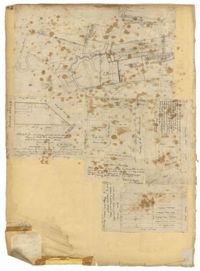
Page 35 of the City Engineer's Plat Book with five plats. Plat 1 shows land located near a creek with large portions marked with a different color. The plat shows a square labelled as "The Mall," and numerous streets, including Bay Street, Drake Street, America Street, Hanover Street, Columbus Street, Cooper Street, Blake Street, Amhurst Street, and Reid Street. There's also a stretch labelled as "Braggs Marsh." Plat 2 shows lots located between Congress Street and Mount Street, including a stretch of Hope Place. Plat 3 features a building labelled "Exchange," on East Bay Street, and near Gibbes Street and Champney Street. Plat 4 shows land with a partition wall and kitchen yards. Plat 5 shows land located near the "Citadel Athletic Field" and Grove Street.
Page 33 of the City Engineer's Plat Book with five plats. Plat 1 shows land located near Mount Street's intersections with "Payne late Legare Street," Larne Court, and "Rutledge late Pinckney Street," including a stretch labelled "Flat Land." Plat 2 shows lots located near the intersection of Beaufain Street and King Street. Plat 3 shows lots located on "Council or New Street," near Gibbes Street, Smith Street, Beaufain Street, Tradd Street, New Street, and Savage Street. Plat 4 shows lots located along South Bay Street, between King Street and Meeting Street. Plat 5 shows lots, buildings, and structures located near the intersection of Line Street and Nassau Street.
Page 39 of the City Engineer's Plat Book with five plats. Plat 1 shows lots and some buildings along East Bay Street, between the intersections with Hassell Street and Cumberland Street. Plat 2 shows lots and some buildings located between Line Street and Shepherd Street. Plat 3 shows lots located between Queen Street and Magazine Street. Plat 4 features a lot and its buildings on King Street. Plat 5 features a lot at the intersection of East Bay Street and Rose Lane.
Page 40 of the City Engineer's Plat Book with three plats. Plat 1 shows lots located between Laurence Street and Boundary Street, and Anson Street and the Charleston Harbor on the Cooper River. Plat 1 also shows East Bay Street, Washington Street, Concord Street, several wharfs, marshland, and a label reading "Mazyck Borough." Plat 2 shows lots on Simmons Street, between King Street and a stretch of marshland. Plat 3 shows lots of land between New Street and Logan Street, and several buildings.
Page 42 of the City Engineer's Plat Book with five plats. Plat 1 shows land between King Street and the Ashley River, and shows bodies of water. Plat 2 shows land between Tradd Street and Payne Street, and several buildings. Plat 3 shows land and buildings on Cumberland Street, and shows two cemeteries, "Cemetery of the Circular Church," and "St Philip's Cemetery." Plat 4 shows plots near the intersection of Henrietta Street and Elizabeth Street. Plat 5 shows lots between "Marsh Street" and "Back Street."
Page 32 of the City Engineer's Plat Book with three plats. Plat 1 shows lots located near the intersection of Tradd Street and Limehouse Street. Plat 2 shows lots located near Elliott Street, Broad Street, and Line Street, near the intersections with Rose Lane, Laurel Street, Percy Street, and Coming Street. Plat 3 shows lots and buildings located between St. Phillip Street and King Street, and Radcliffe Street and Warren Street.
Page 36 of the City Engineer's Plat Book with three plats. Plat 1 shows land located near President Street and Rutledge Avenue, and labels certain marshlands and bodies of water. Plat 2 shows lots located near the intersection of King Street and Grove Street, near Milligan Street. Plat 3 shows land and buildings located near the intersection of Pitt Street and Bull Street.
Page 43 of the City Engineer's Plat Book with two plats. Plat 1 shows lots near Jasper Street, Smith Street, Marion Street, and Radcliffe Street. Plat 2 shows lots between Back Street and Marsh Street, and Magazine Street and Queen Street.
Page 44 of the City Engineer's Plat Book with two plats. Plat 1 shows land between Meeting Street and a stretch of Marsh, and shows a stretch of railroad. Plat 1 also shows "Nassaw Street," Hanover Street, America Street, William Street, Isabella Street, "Rumney Street," Center Street, and "Cool-Blow Street." Plat 2 shows plats on "Rumney Street," between King Street and Meeting Street, including the intersection with Russell Street.
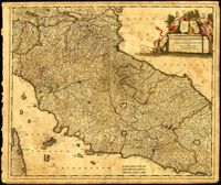
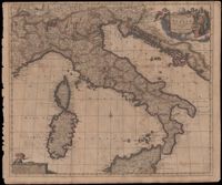
Map of central Italy by Frederick de Wit (1630-1706) showing the grand duchy of Tuscany and the papal states. Title cartouche is decorated with the ball-motif shield of the Medici family; the papal states are represented by the Keys of St. Peter on a shield. Detail on the map includes a road that extends from Rimina on the Gulf of Venetia to Piacenza in the northeast. Amsterdam. 52 x 62cm.
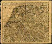
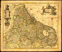
Very elaborate map of the Seventeen Provinces of the Low Countries by Gerrit Van Schagen (1642-1690). North oriented to the right. Figures in title cartouche in upper right include Athena and Pheme. Elaborate explanatory key at upper left. Dangling from the key cartouche is the family crest of Johan Munter, a Dutch East India Company director and burgomaster of Amsterdam. His importance in Amsterdam is evident in the text below the key. 52 x 62cm.
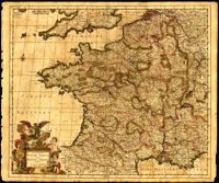
Map of France by Justus Danckerts (1635-1701) includes Belgium and Luxembourg and parts of Switzerland, the Netherlands, Germany and England. Title cartouche depicts a Roman soldier and other allegorical figures. Amsterdam. 52 x 62cm.
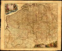
Map of Belgium by Nicolaes Visscher (1649-1702) with Luxembourg and parts of France, the Netherlands and Germany. Title cartouche in upper right corner shows resting warriors and cherubs. A harvest scene surrounds the scale in the lower left corner. Amsterdam. 52 x 62cm.
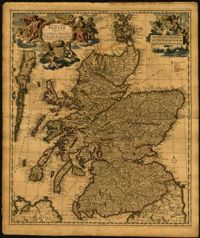
Map of the Kingdom of Scotland by Nicolaes Visscher (1649-1702). Cherubs, unicorn, lion and the Scottish coat of arms decorate the title cartouche and scale. Scale given in Scottish, German and French mileage. Amsterdam. 52 x 62cm.
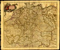
Map of central Europe by Justus Danckerts (1635-1701). Map extends from France in the west to Poland in the east and from Croatia and Italy in the south to the Netherlands in the north. The Hapsburg eagle holds the title banner in the upper left cartouche. Amsterdam. 52 x 62cm.
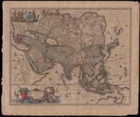
Map of Asia by Gerrit Van Schagen (1642-1690) showing the north coast of Australia and part of the Gulf of Carpentaria. Title cartouche on lower left shows Tritons, sea nymphs and Nereids. On upper left costumed natives are shown with a palm tree, monkey and beaver. 52 x 62cm.
Page 195 of the City Engineer's Plat Book with five plats. Plat 1 shows land located near King Street, Congress Street, and Moultrie Street. Plat 2 shows land located near the intersection of King Street and Simons Street. Plat 3 shows land located near Hassel Street and Pinckney Street. Plat 3 also shows marshland, reclaimed land, several dams, the "Cemetery of the City of Charleston." Plat 4 shows lots located between King Street and Congress Street, and between Moultrie Street and King Street. Plat 5 features lots between Drake Street and America Street, along Cooper Street.
Page 198 of the City Engineer's Plat Book with three plats. Plat 1 shows land between President Street and Rutledge Street, and also shows Ashley Street, Boignard Street, Kennedy Street, Payne Street, Rosemont Street, and Krackes Street. Plat 2 shows lots along Mount Street, between Rutledge Street and Payne Street. Plat 3 shows land between "Town Creek" and Meeting Street, and also shows some marshland and a lot labelled "Roman Catholic Cemetery."
Page 200 of the City Engineer's Plat Book with three plats and two letters written to C.S. Gadsden. Plat 1 shows lots located near President Street, between Spring Street and Line Street, and includes Boigard Street and a projected Kennedy Street. Plat 2 shows lots near President Street, between Line Street and Kennedy Street. Plat 3 shows lots between Line Street and Spring Street, near Rutledge Street.
Page 202 of the City Engineer's Plat Book with one plat. The plat shows lots located between Brigade Street and Williman Street, and between Meeting Street and a strip of land labelled "Atlantic Coast Line R.R." It also shows Nassau Street and Doran Street.
Page 208 of the City Engineer's Plat Book with one plat. The plat shows streets located between the Ashley River and Rutledge Avenue. It also shows Dunnemann Avenue, Grove Street, and Wagener Avenue.
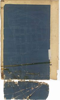
Page 206 of the City Engineer's Plat Book with one plat. The plat shows lots and structures between Charlotte Street and Calhoun Street, near where they intersect with Washington Street. The plat also shows a planing mill, a saw mill, and a dock.
Page 203 of the City Engineer's Plat Book with one plat. An illustrated title card reads "A Plan of Charles Towne Copied with a Pen from an Old Dilapidated Plat without a Date," and depicts a harbor scene with Europeans and enslaved people. The plat labels landmarks and streets using capital and lowercase letters. These locations include Broad Street, the "State House," several churches, Boundary Street, the Exchange, an armory, and a beef market.
Page 204 of the City Engineer's Plat Book with one plat. The plat shows lots and structures located near the intersection of Meeting Street and Broad Street.
Page 209 of the City Engineer's Plat Book with one plat. The plat shows lots on and near Smith Street, between Radcliffe Street and Vanderhorst Street.
Page 137 of the City Engineer's Plat Book with six plats. Plat 1 shows lots located on and near Mazyck Street, between Short Street and King Street. Plat 2 shows lots located on and near the intersection of Pitt Street and Montague Street. Plat 3 features a lot located on the intersection of Archdale Street and Berresford Street. Plat 4 features a lot located at the intersection of Queen Street and Meeting Street. Plat 5 shows a lot located at the intersection of Queen Street and King Street. Plat 6 shows lots located on and near the intersection of Mazyck Street and Magazine Street, including one labelled "Roper Hospital Lot."
Page 129 of the City Engineer's Plat Book with four plats. Plat 1 shows lots between Hayne Street and Market Street, near where they intersect with Meeting Street. Plat 2 features a lot and structures located along Meeting Street, between Hayne Street and Market Street. Plat 3 features a lot located on the "Charleston Harbour on Cooper River." Plat 3 also shows a wharf and other structures. Plat 4 shows the same area as Plat 3.
Page 132 of the City Engineer's Plat Book with two plats. Plat 1 features a plan for the College of Charleston, showing buildings labelled "Charleston College," "Library," "Lodge," and "Charleston Orphan House." Streets on this plat include George Street, Smith Street, College Street, Calhoun Street, St. Philips Street, and Vanderhorst Street. Plat 2 shows lots located near the intersection of Montague Street and Lynch Street.
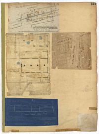
Page 127 of the City Engineer's Plat Book with four plats. Plat 1 shows lots and wharves, including Accommodation Wharf and Brown's Wharf. Plat 2 shows structures on Anson Street. Plat 3 shows lots located near the intersection of Pinckney Street and Anson Street. Plat 4 shows lots located on and near Gadsden Street, between Pinckney Street and King Street.
Page 130 of the City Engineer's Plat Book with three plats. Plat 1 shows lots located on a city block between Meeting Street and Scarborough Street and between Boundary Street and George Street. Plat 2 shows lots and structures located on East Bay Street. Plat 3 shows lots located on the Cooper River channel of the Charleston Harbor, near Concord Street and Wharf Street.
Page 138 of the City Engineer's Plat Book with three plats. Plat 1 features a lot located on Hasell Street, with a large building labelled "St. Mary's Church." Plat 2 shows lots and structures located between Rutledge Street and Trapmann Street, and between Queen Street and Broad Street. Plat 3 features a lot located on Radcliffe Street, between Rutledge Street and Smith Street.
Page 128 of the City Engineer's Plat Book with one plat. The plat shows a city block between Meeting Street and Church Street, and between Cumberland Street and Market Street. A label reads "Champion Cotton Press Co. Lots," and another reads "Tudor Ice House."
Page 131 of the City Engineer's Plat Book with three plats. Plat 1 shows lots and structures located on George Street. Plat 2 features a lot on Rutledge Street. Plat 3 shows lots located on King Street, near its intersection with Clifford Alley.
Page 133 of the City Engineer's Plat Book with one plat. The plat features Colonial Lake, located between Broad Street and Beaufain Street, and between Rutledge Street and Lynch Street.
Page 64 of the City Engineer's Plat Book with six plats. Plat 1 features wharves near Concord Street and shows several other structures. Plat 2 shows "Dock Street or Queen Street" located towards the south, a structures and a creek near the center, and a lot labelled "Capt. Balls Lot" towards the north. Plat 2 also has a large label reading "Cooper River." Plat 3 shows lots located near Cumberland Street between Church Street and Philadelphia Street, and shows several structures on the lots. Plat 4 shows wharves and several buildings located between East Bay Street and the Cooper River. Plat 5 shows a stretch of land between King Street and a body of water, and also shows a stretch of Hasell Street. Plat 6 shows lots on Queen Street, and includes a lot labelled "St. Philips Church Yard." Plat 7 shows lots located near Queen Street, and has a label reading "St. Philips Church Yard."
Page 66 of the City Engineer's Plat Book with fourteen plats. Plat 1 features buildings located near the intersection of King Street and Clifford Street. Plat 2 shows lots and structures located near the intersection of "Comings Street" and Wentworth Street. Plat 3 shows a lot and structures located on Pitt Street. Plat 4 shows lots located on a city block between Smith Street and Pitt Street, and between Montague Street and Wentworth Street. Plat 5 shows lots located on a city block between Montague Street and Wentworth Street, and between South Street and Rutledge Street. Plat 6 features a lot located near the intersection of "Comings Street" and Montague Street. Plat 7 shows lots and some structures located near the intersection of Bull Street and Coming Street. Plat 8 shows a lot and buildings located on Bull Street. Plat 9 Shows lots located near the intersection of Smith Street and Boundary Street. Plat 10 shows lots located on a city block between Lynch Street and Rutledge Street, and between Bull Street and Montague Street. Plat 11 shows lots and structures located near the intersection of Pitt Street and Bull Street. Plat 12 is features a lot located at the intersection of Pitt Street and Bull Street. Plat 13 Features lots located near the intersection of Bull Street and Lynch Street. Plat 14 shows lots located on Queen Street.
Page 62 of the City Engineer's Plat Book with eight plats. Plat 1 shows lots located near East Bay Street. Plat 2 shows a lot on Concord Street, including a wharf. Plat 3 shows three Wharf Lots on Wharf Street, near the intersection with Inspection Street. Plat 4 features a lot on Wharf Street with a dock and a brick building, across the street from a building labelled "Eagle Foundry." Plat 5 shows a lot with several buildings on East Bay Street. Plat 6 shows land near the intersection of East Bay Street and Cumberland Street, with a stretch labelled "Passage to what is now called Central Wharves." Plat 7 shows a wharf and yard on Concord Street, and a structure labelled "Cotton Shed on Brick Pillars." Plat 8 shows a lot located at the intersection of Anson Street and Calhoun Street.
Page 65 of the City Engineer's Plat Book with six plats. Plat 1 shows wharves and other structures located near the intersection of East Bay Street and Elliott Street, and also shows a building labelled "Old Post Office." Plat 2 features a wharf on the Cooper River, and shows several structures. Plat 3 shows wharves and brick storehouses located near the intersection of Prioleau Street and Queen Street. Plat 4 shows lots near the intersection of Bull Street and Smith Street. Plat 5 shows lots and structures located near the intersection of King Street and Morris Street. Plat 6 shows land located along a stretch of Coming Street, between Race Street and Sumter Street.
Page 60 of the City Engineer's Plat Book with eight plats. Plat 1 shows lots near East Bay Street, and the intersection of Washington Street and Inspection Street. Plat 2 shows lots and a building located near Market Street. Plat 3 shows lots located between Washington Street and Marsh Street, and between Inspection Street and Calhoun Street. Plat 4 shows plots located on Market Street with a dotted line labeled "Line of Street proposed by the City." Plat 5 shows plots and structures located near East Bay Street. Plat 6 shows lots located near the intersection of Concord Street and Inspection Street. Plat 7 shows lots located near the intersection of Pinckney Street and East Bay Street. Plat 8 shows a dock and wharf on the Cooper River.
Page 68 of the City Engineer's Plat Book with eight plats. Plat 1 shows lots and some structures located near the intersection of Rutledge and Wentworth Street. Plat 2 features lots and some structures located near Bull Street, between Lynch Street and Gadsden Street, and has a label reading "Mill Pond." Plat 3 shows lots and buildings located near the intersection of Bull Street and Lynch Street. Plat 4 shows a city block between Wentworth Street and Beaufain Street, and Smith Street and Rutledge Street. Plat 5 shows lots located on Beaufain Street. Plat 6 features a lot located on "Comings Street," between Wentworth Street and Montague Street. Plat 7 shows a city block located between Wentworth Street and Montague Street, and Gadsden and Lynch Street. Plat 8 shows a city block located between Lynch Street and Rutledge Street, and Wentworth Street and Beaufain Street.
Page 74 of the City Engineer's Plat Book with four plats. Plat 1 shows lots and some buildings located near Line Street, between King Street and a "Rail Road Company Road." Plat 2 shows lots located along Amherst Street, including one labelled "Cemetery of the Evangelical German Lutheran Church." Plat 3 shows land located between Washington Street and the Charleston Harbor, and includes several structures, a pond, docks, a wharf, and a canal. Plat 4 shows lots and some structures located near the intersection of Smith Street and Calhoun Street.
Page 63 of the City Engineer's Plat Book with five plats. Plat 1 features wharves located near East Bay Street, and shows several docks and buildings. Plat 2 shows wharfs shows a wharf and several buildings located near East Bay Street. Plat 3 features a wharf located near East Bay Street and shows multiple buildings and docks. Plat 4 features a wharf located between East Bay Street and the Cooper River channel, and also shows several buildings. Plat 5 shows lots located on and near Market Street, between East Bay and Concord Street. Plat 6 features a wharf located between East Bay Street and the Cooper River, and also shows several buildings.
Page 70 of the City Engineer's Plat Book with two plats. Plat 1 shows lots located near the intersection of "Broad Road" and George Street, with several buildings and bodies of water. Plat 2 shows a mill pond, marshlands, and structures located near the Ashley River.
This double hemisphere map by Justus Danckerts (1635-1701) is accompanied by two small hemispheres based on the North and South Poles. The South Pole only includes the southernmost tip of South America. The North Pole shows parts of North America, Europe, and Asia. Four scenes surround the map and symbolize the four elements: fire, air, earth and water. In the upper left scene fire is symbolized with a scene of war and destruction and by Cerberus, the three-headed dog who guarded the gate to Hades. The upper right scene is of air with Olympus and the zodiac. The bottom left depicts earth with a pastoral scene symbolizing peace. Ships, a sea monster (whale), Neptune with his wife Amphitrite and their sons, the Tritons, all represent water in the lower right scene. "M King" 1811" written on upper right. Amsterdam. 52 x 62cm.
Page 221 of the City Engineer's Plat Book with six plats. Plat 1 shows lots along Payne Street, between Mount Street and Fishburne Street. Plat 2 shows lots along Lucas Street, near its intersections with Doughty Street and Mill Street, including a lot labelled "City Hospital." Plat 3 shows lots located along Kirkland Lane, between Wentworth Street and Beaufain Street. Plat 4 shows lots located near the intersection of Gadsden Street and Beaufain Street. Plat 5 shows lots located along Lightwood Alley, between Meeting Street and Church Street. Plat 6 shows a lot and building located on Cannon Street, Between Coming Street and a label reading "Church."
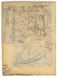
Page 223 of the City Engineer's Plat Book with five plats. Plat 1 shows lots and structures along Poinsett Street, near where it intersects with King Street. Plat 2 shows lots located on Sans Souci Street, near where it intersects with King Street. Plat 3 shows lots located on Line Street, including a lot labelled "City Stables." Plat 4 shows lots along King Street, near where it intersects with Moultrie Street. Plat 5 shows lots and structures located near the intersection of King Street and Romney Street.
Page 227 of the City Engineer's Plat Book with two plats. Plat 1 shows lots and structures located on Grove Street, between King Street and Russell Street. Plat 2 features a "Plot of Ground Surrounding Charleston Colored Industrial School." Plat 2 also shows Fishburne Street, Mount Street, Congress Street, and President Street.
Page 236 of the City Engineer's Plat Book with one plat. The plat features lots located between Romney Street and Cypress Street, and between King Street and a stretch of railroad tracks. Writing in red reads "See Page #242."
Page 230 of the City Engineer's Plat Book with one plat. The Plat features lots located between Chinquapin Street and President Street, and between Bee Street and Spring Street. It also shows several structures, Pine Street, and Chesnut Street. One lot is labelled "Vegetable Garden."
Page 232 of the City Engineer's Plat Book with one plat. The plat shows lots and structures between East Bay Street and the Cooper River, and between Society Street and Vernon Street. The plat also shows Washington Street, Marsh Street, Concord Street, Vernon Street, and Wharf Street.
Page 233 of the City Engineer's Plat Book with one plat. The plat features a stretch of marshland located east of Bay Street. The plat also shows America Street, Cooper Street, Blake Street, several creeks, and land labelled "Magazine."
Page 234 of the City Engineer's Plat Book with one plat. The plat shows lots and structures located on Mill Street, President Street, Lucas Street, and Sixth Street. It also shows a lot labelled "U. S. Arsenal."
Page 231 of the City Engineer's Plat Book with one plat. The plat features lots belonging to "The Cannonsboro Whf & Mill Co." It shows Bee Street, Doughty Street, President Street, Lucas Street, and Mill Street.
Page 166 of the City Engineer's Plat Book with five plats. Plat 1 shows lots and structures located near the intersection of Columbus Street and Meeting Street. Plat 2 features lots located along Moultrie Street, between Meeting Street and Russel Street. Plat 2 also shows King Street and Hampton Street. Plat 3 shows lots located between Meeting Street and a line labeled "South Carolina R. R. Company," near Romney Street, Addison Street, and Poinsett Street. Plat 4 shows a lot located on the north side of Amherst Street. Plat 5 shows lots located near the intersection of Bay Street and Blake Street.
Page 162 of the City Engineer's Plat Book with three plats. Plat 1 shows land located near Payne Street with several streams. Plat 2 shows lots located in the Village of Hampstead, located near America Street. The plat also shows marshland and streams. Plat 3 has numerous tears and holes. Plat 4 shows lots and structures located between Meeting Street and Lynch Street.
Page 169 of the City Engineer's Plat Book with three plats. Plat 1 shows lots and structures on and near Dehon Street, between King Street and Meeting Street. Plat 2 shows lots located between King Street and Meeting Street, south of Romney Street. Plat 3 shows lots and structures located between Chapel Street and Charlotte Street, near where they intersect with Elizabeth Street. One lot is labelled "St. Luke's Church."
Page 165 of the City Engineer's Plat Book with three plats. Plat 1 shows lots located near a "Public Road from and to Charleston." It also shows marsh land, a fishpond, and a garden. Plat 2 shows land located near the intersection of America Street and Brigade Street. Plat 3 shows lots located near the intersection of Meeting Street and Riker Street, including a stretch of land labeled "Low Ground."
Page 164 of the City Engineer's Plat Book with three plats. Plat 1 shows lots located between Meeting Street and Aiken Street, and between Cooper Street and Line Street. Plat 2 shows lots located on Felix Street. Plat 3 shows lots located on Grove Street, and shows a stream and a label reading "Frenchman's Hill."
Page 167 of the City Engineer's Plat Book with two plats. Plat 1 shows lots located between Meeting Street and a line labelled "So. Ca. R. R." Plat 2 shows lots located between Moultrie Street and Line Street, and between America Street and Meeting Street. Plat 2 also shows lots between Hampton Street and Moultrie Street, West of Meeting Street.
Page 163 of the City Engineer's Plat Book with two plats. Plat 1 shows lots and structures located on Friend Street, near its intersections with Queen Street, Broad Street, and an unlabeled street. Plat 2 shows lots located on King Street, near where it intersects with Broad Street.
Page 177 of the City Engineer's Plat Book with two plats. Plat 1 shows lots located between Meeting Street and King Street, near Russell Street, "Rumney" Street, and Poinsett Street. Plat 2 shows lots, structures, and streams located near Hanover Street, America Street, and Payne Street.
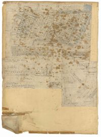
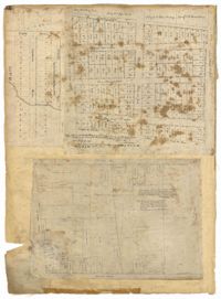
Page 92 of the City Engineer's Plat Book with six plats. Plat 1 features a "Plan of the Citadel Square," located between King Street and Meeting Street, and between Calhoun Street and Hudson Street. Plat 1 also shows several buildings, including the Citadel, the "U.S. Gov. Stables," and the "U.S. Hospital." Plat 2 shows lots and several buildings located between Smith Street and Franklin Street. Plat 3 shows lots and structures located along Market Street, between Church Street and Meeting Street. Plat 4 shows lots and structures located near Calhoun Street. Plat 5 shows several lots and structures located on King Street. Plat 6 is affixed to the page so it folds out, and shows lots located near Spring Street, between Chesnut Street and President Street. Plat 6 also shows Pine Street, Cannons Court, and Bee Street.
Page 88 of the City Engineer's Plat Book with eight plats. Plat 1 shows a stream and marshland starting at the Ashley River. Plat 2 features land located near the Ashley River and Grove Street. It also features several structures, some marshland, and a creek. Plat 3 shows land located near Grove Street, including some structures, some marshland, and a stream. Plat 4 shows land located Grove Street, including some buildings, a creek, and marshland. Plat 5 shows lots located between a stretch of marsh and Rutledge Avenue. Plat 5 also shows Congress Street, Legare Street, Huger Street, Moultrie Street, and a race track. Plat 6 features Washington Race Course, located between Grove Street and Moultrie Street, and between Congress Street and an unlabeled Street. Plat 7 shows "34 acres of Marsh" located between the Ashley River and a public cemetery. Plat 8 shows marshland located on the Ashley River, near "new Spring Street" and a creek.