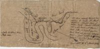
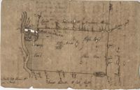
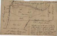
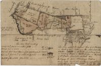
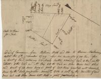
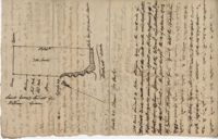
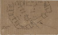
Plan of the old field tract in St. John's Parish late belonging to Francis Huger now to John Ball. Compiled and copied from original papers. Names associated with this plat are James Child, Francis Huger, John Ball, James Child, William Walter [?], Nathaniel Johnson, John Archdale, Thomas Droughton, P. Pawley, J. Child and Hentey [?].
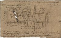
Plat of three tracts of land in a deed of conveyance from Peter Michau to Theodore Gaillard, the plats being 200, 300, and 500 acres respectively. Each plat contains a short explanation as to its conveyance and contains little geographic detail. Names associated with this plat Peter Michau, Theodore Gaillard, Isaac Chardon, Andrew DeLavillette, Thomas Broughton, Paul Mazyck, Nicholas Lenude, Isaac Michau, Andrew Thimbert, James St. John and Thomas Johnson.
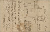
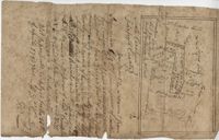
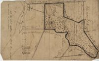
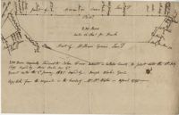
Plat includes 272 Acres with the Broad Road bisecting the property. Names associated with this plat are William Perry Perry, N. Bradwell, Archer Smith, the Ministry Lands and Joseph Perry. Notable geographic locations include St. George’s Parish, Bach Hill, Dorchester, and Broad Road.
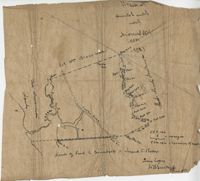
Copy of plat of 300 acres of land situated in Craven County on the north side of the Santee River bounding north east on Bennett's land and the other sides on vacant land. Names associated with this plat are Susannah Williams, Thomas Ferguson, Moses Bennett, and Benjamin [?]. Notable geographic locations include the Santee River, Craven County [now in parts of Berkeley, Charleston, Georgetown, and Williamsburg counties], and Georgetown.
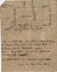
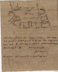
A collection of five maps and three charts describing land owned by Jonah Horry in South Carolina. The first four maps were drawn from surveys made by John Goddard in 1793; the last map was drawn from a survey made by John Horry Dent in 1836.
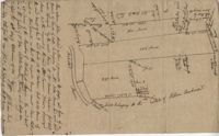
Copy of a tract of 127 acres in the marsh on the Ashepoo River belonging to Sarah McPherson. Little detail included in the plat. Names associated with this plat are Sarah McPherson, Willliam Spense, and Joshua McPherson. Notable geographic locations are the Ashepoo River, Deer Creek, Ladson, and Colleton County.
Copy of plan of a plantation on Stono Swamp commonly called Stono Plantation belonging to Thomas Ferguson. Contains 630 acres. Approximately 360 acres is swamp and approximately 270 acres is highland. Names associated with this plat are Thomas Ferguson, George Haig, Joseph Farr, Mary Williams, Smith and John McSweeney. Notable geographic locations include Stono Swamp, Stono Plantation and Charleston.
John Grigg 69 Acres Certified for him Feb 28th 1793. John Grigge 69 acres recorded 24 September 1793. Names associated with this plat are John Grigg, William Jones, William Burens, Crompton, H. J. [?] Kennedy, Barnes, Bowels, Somes [?] and John Buren. Notable geographic locations include Fairfield County, Camdon [Camden?] District, and Sawines [?] Creek.
Plan of a tract of land on the NE side of Edisto River called Riverside Plantation and contains 1100 acres belonging to estate of Thomas Ferguson lately sold to Martin. Names associated with this plat included Benjamin Berry, Bull, Martin, John Eberley, Edward Perry, and Thomas Ferguson. Notable geographic locations include St. Paul's Parish, the Edisto River, Parkers Ferry, Public Road to Charleston, Riverside Plantation, and Charleston District.
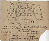
Plat contains 310 acres layer out for John Gamble granted November 6, 1706. Plat contains location of house. Names associated with this plat are John Gamble, Gideon Fishero, Amos Donoly, John Deas, Francis Cobia, Purull, and F. Bremar.
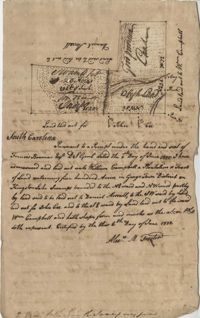
“Plan of parcel of land of late belonging to John Jones and now sold and conveyed by the said Jones to James Carsen for 850 acres but the request of the said Carsen. The said tract of land has been resurveyed and find it to contain but 805 acres of land or there about, so that the original survey must have taken in 45 acres of the marshes of Bohicket River...true copy taken from the original plat in the property of Mr. William Carsen in June 1794." Names associated with this plat are John Carsen, John Jones, James Carsen, William Chambers, James Young, Thomas Winborns, McDoul, Abigail Winborn, John Gibbs, Wilkins, and William Carsen. Notable geographic locations include St. John's Parish, Bohicket River, Wadmalaw River and Johns Island.
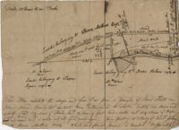
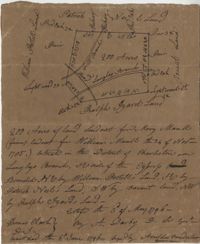
Plat contains 211 acres copied from a release form annexed to Nathaniel Broughton to Alexander Broughton. Part of Mulberry Tract. Names associated with this plat are William John Broughton, Nathaniel Broughton, Alexander Broughton and A. Domini. Notable geographic locations include Doken Creek, The Farm, St. John's Parish and Long Branch Creek.
Copy of a plan of a plantation or tract of land lately sold to Isaac Holmes by James Legare lying on Johns Island, Charleston District from a plan annexed to Arleas from Thomas Legare and annexed to Isaac Holmes 1784. 380 acres. Names associated with this plat are Thomas Legare, James Legare, and Isaac Holmes. Notable geographic locations include Charleston District and Johns Island.
Plan of a parcel of land situated on Johns Island and containing 86 1/2 acres. Being part of a body of land belonging to Thomas Mathews. Bounded northwardly by a public road, eastwardly on James Legare's land, and southwardly on land belonging to Isaac Holmes and Thomas Legare. Intended to be conveyed to Isaac Holmes. Names associated with this plat are Thomas Mathews, Isaac Holmes, Thomas Legare, William Stanyarn, Matthews and James Legare.
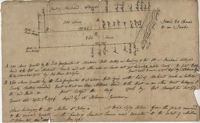
True copy of a plan surveyed for an inland plantation for Breton Singletary containing 500 acres situated in Craven County butting and bounding northerly on late William North, southerly by Singletary and all other sides on lands not yet laid out. Names associated with this plat are Thomas Broughton, Breton Singletary, Richard Beresford, William North, Charles Craven, Alexander Heward, John St. Martin, Thomas Valley, Mary Henry, and Robert Smith. Notable geographic locations include Wambaw, St. Thomas Parish, and Craven County [now in parts of Berkeley, Charleston, Georgetown, and Williamsburg counties].
Copy of a plat of 490 acres owned by Francis Smith annexed to the lands owned by Laughlin McIntosh. Names associated with this plat are Francis Smith, Laughlin McIntosh, Beadon Colonel, Captain Hutchinson, and Thomas Fleming. Notable geographic locations include St. Bartholomew's Parish, Chickaw and Charleston District.
Copy of two adjoining plats of lands on Johns Island originally granted to Ambrose Hill now belonging to Miller St. John. Copied from the plats annexed to the original grants in 1795. Names associated with these plats are Ambrose Hill, Miller St. John, Richard Floyd, the Lords Proprietors, Job Howe, N. Johnson, Thomas Broughton and Lambert Lanee. Notable geographic locations include Johns Island, Ambrose Hill, Bohicket Creek, and Colleton County.
Plat of two tracts of land on Johns Island, both are 300 acres. Notes give a brief description of the properties, the drawings include very little detail. Names associated with this plat include John Prescot, Anthony Mathews, Graemede, the Lords Proprietors, Robert Cole, Robert Gibbs, Heufville, Arnold, Richard Floyd and Thomas Broughton. Notable geographic locations include Colleton County, Kywah [Kiawah] Creek, and Johns Island.
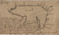
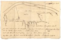
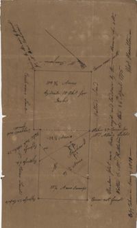
500 acre plat given to William Campbell in the Georgetown District on Kingston Lake Swamp, shows highlands, swamp, indigo area, and an area named food provision, shows details and surrounding property owners.
Plat of land which includes a marsh and creeks, very little other detail. Names associated with this plat are Purcell, Thomas Rose, John Blade, and E. Rivers. Notable geographic locations include Tiger Swamp.
Plat of 237 acres belonging to Rob Reeves Gibbes. Detailed marsh and high land along with the location and outline of a house. Names associated with this plat are Robert Reeve Gibbes, Nathaniel Heyward, John Gibbes, Thomas Gibbes, and Lewis Gibbes. Notable geographic locations include the Combahee River, Tupelo Swamp, and Charleston District.
Plat contains 420 acres But is to the estate of Fulmer and Shubrick and to Shubreek and Hewart also bounding to Hapensack and Izard. Plat includes the location of the house and paths connecting the property to its neighbors. Names associated with this plat include William Conrade Heekeley, Shubrick, Fulmer, Hewart, Hapensack, Ralph Izard, and Thomas Abernethie. Notable geographic locations include St. James Parish, Goose Creek, Wolf Castell, Berkeley County, and Charleston District.
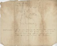
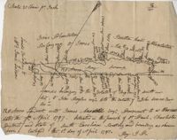
Sketch of the survey ad laying out of a small tract called Red Branch on the west side of the Cooper River containing 6 acres lately sold by Middleton to Leval part of 400 acres tract granted to Dr. Snow. Names associated with this plat are Peter Pamplat, Peter Gray, Snow, and Middleton.
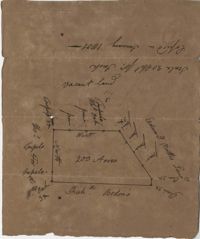
Plat includes Langley Branch Road going through plat as well as a road. Plat consists of 200 acres. Names associated with this plat are Mary Manlt, William Manlt, William Postell, Patrick Neel, Ralph Izard, Thomas Clark, A. Darby, Amoldus Vanderhorst, Margaret Manlt and W.S. Smith. Notable geographic locations include St. George’s Parish, Langley Branch, Cypress Road, Dorchester, Cypress Swamp, and Charleston District.
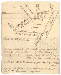
"A Plan of a Plantation or Tract of Land on Penny Creek a Branch of Ponpon or Edisto River late the property of Joseph Bee Esquire now belonging to John Champney Esquire." Plat contains 687 acres on the north side of Penny Creek the plat is divided by use of lands and the location of structures on the property. Names associated with this plat are John Champney, Dr. John Mitchell, Thomas Bee, Joseph Bee, and George Savage. Notable geographic locations include Penny Creek, Edisto River, Pon Pon River, Landing Road, and Bridge Road.
200 Acre plot of land laid out to John Freer, shows some creeks and trees, no land type or details. Names associated with this plat are John Freer, Stephen Bull, Joseph Blake, William Weston, William Green, and B. Sam. Notable geographic locations include Colleton County, Freer District, and Wadmalaw River.
169 acre plot given to Kent McCall, shows roads and surrounding neighbors, shows the Ashley River and some trees on the property borders. Names associated with this plat are Kent McCall, Thomas Parker, Roger Smith, Burnard Elliott, Crughtton, William Elliott, John Heard, Benjamin Dart, Elizabeth McCall, John Ward, John Parker, and Thomas Parker. Notable geographic locations include St. Andrew's Parish and the Ashley River.
128 acres situated in the Charleston district unto James Maxwell situated in the parish of St. Paul, Charleston District April 1, 1797. Names associated with this plat include James Maxwell, Jane Ladson, Smith, John Boyles, John Somers and Brigdon Smith. Notable geographic locations include St. Paul's Parish, Jerico Plantation, Bretton Hall Plantation, Bay Swamp, and Charleston District.
Copy of tract of land containing 200 acres, butting and bounding south and west by William Elliott, and on the east by Clay, and to the north by John Rivers. Names associated with this plat include William Webb, Thomas Mellichamp, Butler, William Elliott, William Clay, Shem, John Rivers, John S. Cripps, Samuel Jones, the Lords Proprietors, and Daniel Gibson.
Copy of Plat of 157 acres of land laid out to Harrison on Wadmalaw Island at the head of Wadmalaw River. Names associated with this plat are Christopher Harrison, Henry Walkins, and Luna Williams.
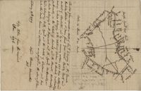
Tract of land on Pawley's Island containing 10 acres situated to the south west of Hasell, known as Lot No.6. Names associated with this plat are Colonel P. Fraser, Hasell, Goudin, Robert Campbell, Anderson, Hoben [?], Joseph Port-Geaur, Thomas Bouhia [?], May Smith, H. Eclert [?], D. Wary, W. Snipes, Mazyck, Mitchell and Grant. Notable geographic locations include Pawley's Island, Georgetown District and Sash Creek.
Copy of a plat of annexed to the original grant to John Stanyarn for 300 acres on Wadmalaw Island now belonging to Barnet Adams. Names associated with this plat include Barnet Adams, Edmund Bellinger, John Stanyarn, William Green, Joseph Tobias, Christopher Williamson, John Mill and Winborne Laughton. Notable geographic locations include Wadmalaw Island and Bohicket Creek.
Copy of a plat of 355 Acres of land in Berkeley County near the West side of Cooper River, shows surrounding properties, doesn’t include land type or detailed notations. Names associated with this plat are Edward Keating, William Kimlough, Buvet, Matthew Beard, Colonel Chicken, Chapennoun Elliott, Robert Daniell, Longrove Thomas, Edward Keyting, Andrew Allens, William Gibbons, James Kenloch, William Adams, Allen Anderson, William Gibbons, Matthew Benson, Thomas Smith, John Vecandge [?], Francis Ternandol, and Allen Andrew. Notable geographic locations include St. James Parish, Goose Creek, Cooper River, and Berkeley County.
Copy of a plat of 200 acres in St. George’s Parish. The property lines and various trees located on them are the only details included. Names associated with this plat are G. Wagner, Samuel Jones, Thomas Hotkins, Francis Yonge, and Robert Daniell. Notable geographic locations include the Stono River and Berkeley County.
Plat of 300 acres in St. Andrew’s Parish on the Stono River originally granted to William Branford. At the time of the copy it belonged to George Wagner. Names associated with this plat are William Branford, George Wagner, Egerton Leigh, Thomas Boone and Elizabeth Hutchins.
Plat of 57 acres belonging to Dorothy Jones on the Stono River. At the time of the copy belonged to George Wagner. Names associated with this plat are Dorothy Jones, George Wagner, Bull and John St. James.
Copy of a plat of land in St. Andrew’s Parish, 103 acres are marsh land. Little other detail or explanation. At the time of the copy belonged to George Wagner. Names associated with this plat include Stephen Bull, Thomas Jones, George Wagner, Richard Godfrey, Nathaniel Brown and Thomas Jones.
Plat of land annexed to a release from Benjamin Elliott to William Brandford for 362.5 acres. At the time of the copy belonged to George Wagner. Names associated with this plat include William Branford, Benjamin Elliott, Wagner George and Thomas Elliott.
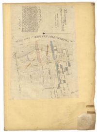
Page 12 of the City Engineer's Plat Book with two plats. Plat 1 shows plots near Coming Street, St. Phillip Street, King Street, Meeting Street, and Vanderhorst Street. Plat 2 Shows lots on Queen Street near the intersections with East Bay Street and Prioleau Street, has the label "Charleston Harbour Cooper River" on the right-hand margin.
Copy of a plat of 200 acres in St. George’s Parish. The property lines and various trees located on them are the only details included. Names associated with this plat are Benjamin Cattell, Richard Bedon, and Edward North. Notable geographic locations are St. George's Parish and Cypress.
Plat consists of 100 3/4 acres. Names associated with this plat include William Walter, William Kittlebum, Coachman, Thomas Hamilton, Benjamin, Richard and Allen. Notable geographic locations include St. George Parish and Cypress.
A 550 acre plot of land given to Francis Middleton, the entire plot is labeled as marsh located on the banks of the branches of the Santee River. Names associated with this plat are Francis Middleton, Ephraim Mitchell, Josh Purcell and A. Darby. Notable geographic locations included are St. James Parish.
Copy of a plan annexed to a deed for 177 acres given by Ebenezer Simmons to the John's Island Society lying adjoining the church on Johns Island. Names associated with this plat are Johns Island Society, Ebenezer Simmons, James Lawson, Robert Gibbes, William Boone, John Freer, George Scott, Thomas Smith, Daniel Doyley, Joshua Ward, John Hanyon, John Moultrie, Isaac Wraught, and John Stanyarn.
Plat of land on Goose Creek belonging to Dr. Charles Drayton. Details include an area of marsh and the location of Goose Creek. Names associated with this plat are Dr. Charles Drayton, Michau, Manigault and Richards.
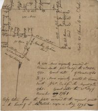
"In the above delineated plat A represents a tract of land containing 120 acres originally granted to William Sanders the 10 May 1734 for 100 acres, now held by William Allen Milis B containing 134 acres is part of a tract granted to Roger Simner the 21st day of April 1733 for 4200 acres and now held by William Edward Perry - Situated on the Cypress Swamp in St. George’s Parish Berkeley County and… a fore said and butting and bounding and having such marks and shape as are about set the Certified the 23rd July 1775 by John Fenwick Copy taken from the original in July 1801." Names associated with this plat are William Allen Milis, Roger Simner, William Edward Perry, William Benjamin Coachman, William John Glaize, Daniel Blake, William H. Drayton, Watter, Sanders, and John Fenwick. Notable geographic locations include St. George's Parish, Cypress Swamp, and Bedons.
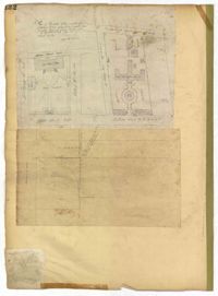
Page 132 of the City Engineer's Plat Book with two plats. Plat 1 features a plan for the College of Charleston, showing buildings labelled "Charleston College," "Library," "Lodge," and "Charleston Orphan House." Streets on this plat include George Street, Smith Street, College Street, Calhoun Street, St. Philips Street, and Vanderhorst Street. Plat 2 shows lots located near the intersection of Montague Street and Lynch Street.
Page 23 of the City Engineer's Plat Book with one plat. The plat shows lots, buildings, shoals, and mud flats located near the Charleston Harbor on the Cooper River, Concord Street, Pinckney Street, and East Bay Street.
200 acres laid out to Jonathan Stocks situated in Colleton County lying on the side of Kywa [Kiawah] Creek, shows surrounding properties with no land type or detail. Names associated with this plat are Jonathan Stock, John Jones, John Edenborough, Thomas Jones, and Thomas Weatherby.