St. Andrew's Parish Plat 1742
Close Viewer
- Title:
- St. Andrew's Parish Plat 1742
- Date:
- 1799
- Description:
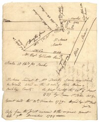
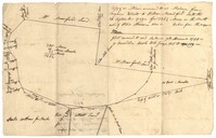
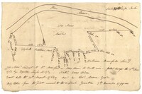
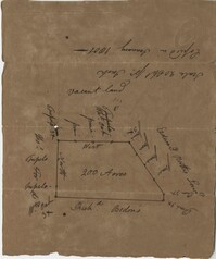
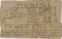
- Copy of a plat of land in St. Andrew’s Parish, 103 acres are marsh land. Little other detail or explanation. At the time of the copy belonged to George Wagner. Names associated with this plat include Stephen Bull, Thomas Jones, George Wagner, Richard Godfrey, Nathaniel Brown and Thomas Jones.
- Collection Title:
- John McCrady Plats and Deeds Collection
- Contributing Institution:
- South Carolina Historical Society
- Media Type:
- Maps
- Personal or Corporate Subject:
- Saint Andrew's Parish (S.C.)
- Topical Subject:
- Conveyancing--South Carolina, Maps, and Surveying--South Carolina
- Language:
- English
- Shelving Locator:
- 510.00, Box 3, Folder 92
- Date Digital:
- 2018-09-26
- Digitization Specifications:
- 400 dpi, 24-bit depth, color, Bookeye 4 Basic, Archival masters are tiffs.
- Internet Media Type:
- image/jpeg
- Copyright Status Statement:
- Public Domain.
- Access Information:
- For more information and re-use requirements contact the South Carolina Historical Society, Charleston, SC, 29401.
- Admin ID:
- 223406
Permalink