Search Home
Search in
search for
Simple Search
Page Content Search
Title Search
Creator Search
Subject Search
Search
search icon
Search
Search Constraints
Start Over
You searched for:
Media Type
Maps
✖
Remove constraint Media Type: Maps
Date Range (beta)
1750
to
1774
✖
Remove constraint Date Range (beta): <span class="from" data-blrl-begin="1750">1750</span> to <span class="to" data-blrl-end="1774">1774</span>
« Previous
|
11
-
20
of
23
|
Next »
Sort
by Relevance
Relevance
Title
Date (Newest)
Date (Oldest)
Number of results to display per page
10
per page
10
per page
20
per page
50
per page
100
per page
View results as:
list icon
List
masonry icon
Masonry
Search Results
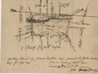
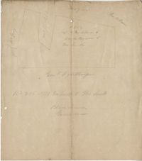
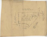
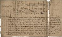
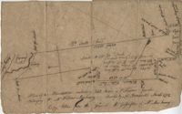
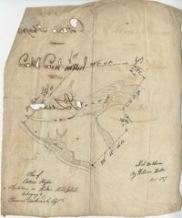
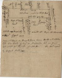
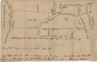
Plat in St. James Parish 1770
Wall Eye Swamp Plat 1770
Plat in Granville 1770
Charleston County Plat 1771
Plat East of Pon Pon River 1771
Ashley River Plat 1772
Cotton Hope Plantation Plat 1773
Wadmalaw Creek Plat 1773
Plat Near Cooper River 1774
Cooper River Plat 1774
« Previous
Next »
1
2
3
Limit your search
Collection
John McCrady Plats and Deeds Collection
21
City Engineers's Plat Book, 1671-1951
2
Contributing Institution
South Carolina Historical Society
21
City of Charleston
2
The Charleston Archive at CCPL
2
Media Type
Maps
✖
[remove]
23
Subject (Topic)
Maps
21
Surveying--South Carolina
21
Conveyancing--South Carolina
21
Surveys
2
Cadastral maps
2
Subject (Geographic)
Charleston (S.C.)
3
Santee River (S.C.)
3
Ashley River (S.C.)
2
Saint Paul’s Parish (Charleston County, S.C.)
2
Cooper River (S.C.)
1
Saint Luke’s Parish (S.C.)
1
Ashepoo River (S.C.)
1
Cooper River (S.C.)
1
Hilton Head Island (S.C.)
1
Santee (S.C.)
1
more
Subject (Geographic)
»
Date
1770
4
1773
2
1774
2
1742
1
1743
1
1746
1
1847
1
1873
1
1874
1
1877
1
more
Date
»
Date Range (beta)
1750
to
1774
✖
[remove]
23
1750
to
1751
0
1752
to
1754
4
1755
to
1756
1
1757
to
1759
2
1760
to
1761
1
1762
to
1764
1
1765
to
1766
1
1767
to
1769
1
1770
to
1771
6
1772
to
1774
6
Current results range from
1752
to
1774
Date Range (beta) range begin
Date Range (beta) range end
View larger »