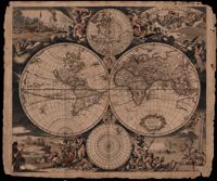
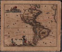
This double hemisphere map by Justus Danckerts (1635-1701) is accompanied by two small hemispheres based on the North and South Poles. The South Pole only includes the southernmost tip of South America. The North Pole shows parts of North America, Europe, and Asia. Four scenes surround the map and symbolize the four elements: fire, air, earth and water. In the upper left scene fire is symbolized with a scene of war and destruction and by Cerberus, the three-headed dog who guarded the gate to Hades. The upper right scene is of air with Olympus and the zodiac. The bottom left depicts earth with a pastoral scene symbolizing peace. Ships, a sea monster (whale), Neptune with his wife Amphitrite and their sons, the Tritons, all represent water in the lower right scene. "M King" 1811" written on upper right. Amsterdam. 52 x 62cm.
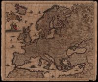
Map of Europe by Justus Danckerts (1635-1701) includes western Russia and Iceland. The title cartouche on left supported by putti. Other embellishments show the abduction of Europa by Zeus, a sea monster and ships on the oceans. Amsterdam. 52 x 62cm.
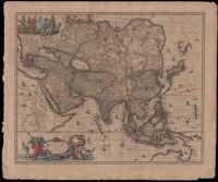
Map of Asia by Gerrit Van Schagen (1642-1690) showing the north coast of Australia and part of the Gulf of Carpentaria. Title cartouche on lower left shows Tritons, sea nymphs and Nereids. On upper left costumed natives are shown with a palm tree, monkey and beaver. 52 x 62cm.
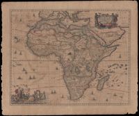
The map by Gerritt Van Schagen (1642-1690) captures the European misconceptions of Africa typical of the late seventeenth century. The Nile appears to be rising from the three lakes of Zaire, Zembre and Zafflan. The prime meridian, the zero-degree longitude line, is plotted through the Canary Islands which to the ancients was the western edge of the inhabited world. The interior is decorated with monkeys, elephants, lions, rhinoceroses, leopard and ostriches. The sea is decorated with ships, whales and flying fish. The title cartouche in the upper left right is surrounded by two Africans, one holding a scorpion and the other a cornucopia with sea sprites at their feet. The elaborate decoration at the lower left is Neptune surrounded by his wife, Amphitrite, and their sons, the Tritons, along with Nereids, the sea nymphs. 52 x 62cm.
In this map by Gerrit van Schagen (1642-1690) California is a large island, there is one Great Lake (Lac contenant), a large open lake in place of the western Great Lakes, and the conjectural Northwest Passage, with the Straits of Anian. The elaborate title cartouche at the bottom left contains scenes of native Americans hunting, panning for gold and a chief standing beneath an umbrella. Also, the map shows other small illustrations: a war being waged by Indians in South America and a figure lying in a hammock. There is a large vignette at the top left of Neptune and his sons, the Tritons. 51 x 62cm.
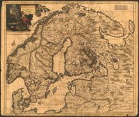
Map of Scandinavia by Justus Danckerts (1635-1701) includes the Baltic and part of Russia. The title cartouche with an armorer's forge and Swedish coat of arms probably alludes to Sweden's power in the late seventeenth century. 52 x 62cm
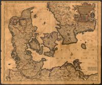
Map of Denmark with the Baltic Sea and the southern portion of Sweden by Justus Danckerts (1635-1701). Title cartouche displays the Danish coat of arms. 52 x 62cm.
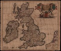
Map of the British Isles by Theodore Danckerts (1663-1727) also includes part of the European coast. The decorative title cartouche is in the upper right corner with putti supporting the shields of Scotland, Ireland and England; the mileage scale is given in the lower left corner. Amsterdam. 52 x 62cm.
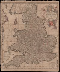
A very informative map of the road network with England and Wales. This map was cooperatively published by Nicholas Visscher (1649-1702), a cartographer from Amsterdam, and John Overton (1640-1708), a publisher from London. The imprint of Visscher and Overton tells the reader that the map may be bought in both Amsterdam and London. The maps title is enclosed in a decorative cartouche on the upper right. At the top of the title is the royal coat of arms supported by a lion and a unicorn and at the bottom is the shield of England. Amsterdam. 52 x 62cm.
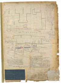
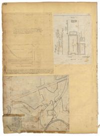
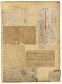
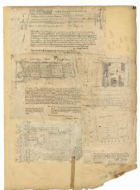
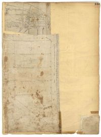
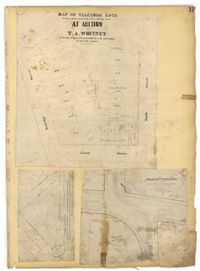
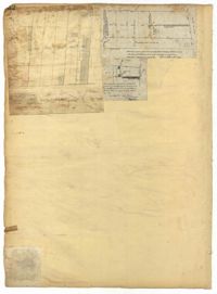
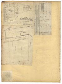
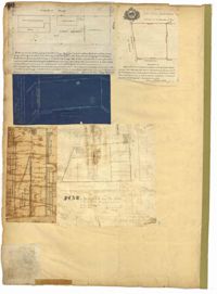
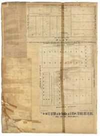
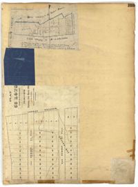
Page 1 of the City Engineer's Plat Book with four plats. Plat 1 shows the intersection of East Bay Street and Market Street, and labels reading "New Custom Ho.," "Old Flash," "Scale House," and "Market." Plat 2 shows a stretch of East Bay Street from the intersection with Guignard Street to Pritchard Street, including the bridge crossing over Canal Street. Plat 3 shows the intersection of Tradd Street and Greenhill Street. Plat 4 features Beaufain Street's intersections with St. Phillip Street and Archdale Street, and features a plot of land labelled "Normal School Yard."
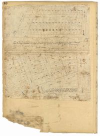
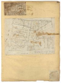
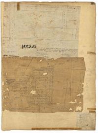
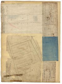
Page 10 of the City Engineer's Plat Book with two plats. Plat 1 shows plots located near Pointset Street and Grove Street between King Street and Russell Street. Plat 2 shows plots near Judith Street and Chapel Street, and includes "Beaufort's Court" and "Heyward's Court."
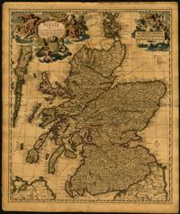
Map of the Kingdom of Scotland by Nicolaes Visscher (1649-1702). Cherubs, unicorn, lion and the Scottish coat of arms decorate the title cartouche and scale. Scale given in Scottish, German and French mileage. Amsterdam. 52 x 62cm.
Page 100 of the City Engineer's Plat Book with four plats. Plat 1 features lots located near the intersection of Broad Street and Friend Street. Plat 2 shows lots and structures on Meeting Street. Plat 3 shows land located near the intersection of Drake Street and Cool Blow Street, including a stretch of the North Eastern Rail Road, a creek leading to the Cooper River, and some marshland. Plat 4 is affixed to the page so it folds in and out, and shows lots located near a stream, Pine Street, Alleyway Street, Norman Street, and Ashton Street.
Page 101 of the City Engineer's Plat Book with two plats. Plat 1 shows lots located between Washington Street and Wharf Street, and between Calhoun Street and Laurens Street. Plat 2 shows lots located near the intersection of Rutledge Avenue and Line Street, with several buildings labelled.
Page 102 of the City Engineer's Plat Book with five plats. Plat 1 shows lots along a stretch of Rutledge Avenue from Grove Street to Sans Souci Street. Plat 2 features a projected extension of Rutledge Avenue from Mt. Pleasant Road to Heriot Street, and also shows a lot labelled "S.C. Agricultural Society." Plat 3 shows a projected extension Rutledge Avenue, extending from Sans Souci Street to Mt. Pleasant Road. Plat 4 shows a projected expansion of Rutledge Avenue through Heriot Street, and also shows a plot labelled "Agricultural Society." Plat 5 shows a projected extension of Rutledge Avenue from Grove Street to Simons Street, and also shows King Street.
Page 103 of the City Engineer's Plat Book with three plats. Plat 1 shows lots located between President Street and Norman Street, near where they intersect with Spring Street. Plat 2 shows lots and some buildings along Bogard Street, between Laurel Street and Percy Street. Plat 3 shows a lot and several buildings located on Percy Street.
Page 104 of the City Engineer's Plat Book with one plat. The plat shows lots located between Moultrie Street and Cunnington Street. It also shows Lemon Street, Lee Street, Price Street, and Magnolia Street. It also shows a plat labelled "Artilery Society" and another plat labelled "Magnolia Cemetery."
Page 105 of the City Engineer's Plat Book with seven plats. Plat 1 shows several lots located on Chalmers Street. Plat 2 shows lots located near the intersection of East Bay Street and Market Street, and several structures, including docs and wharves. Plat 3 features lots and structures located on Chalmers Street. Plat 4 features a lot located on the intersection of Church Street and Waters Street, and shows several structures. Plat 5 shows a lot and several structures located on Waters Street. Plat 6 features a lot and buildings located on Broad Street. Plat 7 features the profiles of streets where tidal drains will be built. The profiles include Calhoun Street, Mazyck Street, Logan Street, Tradd Street, Coming Street, Chesnut Street, Spring Street, and Meeting Street.
Page 106 of the City Engineer's Plat Book with ten plats. Plat 1 features a lot and its buildings located near the intersection of King Street and Tradd Street. Plat 2 features a lot and buildings located between Church Street and Water Street, near where the latter intersects with East Bay Street. Plat 3 shows lots located near the intersection of King Street and Grove Street. Plat 4 features a plat and building located on Church Street. Plat 5 features a lot located on the intersection of East Bay Street and Elliott Street. Plat 6 shows a lot located between two streets leading to wharves. Plat 7 shows lots, wharves, and docks located near the intersection of Market Street and East Bay Street. Plat 8 features a wharf and lot located near the intersection of Legare Street and South Bay Street. Plat 9 shows lots located on and near the intersection of Broad Street and East Bay Street. Plat 10 shows lots and some structures located on East Bay Street.
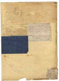
Page 107 of the City Engineer's Plat Book with two plats, labelled 3 and 4. Plat 3 features a lot and buildings located on the intersection or Tradd Street and East Bay Street. Plat 4 shows lots located near Gibbes Street, Tradd Street, New Street, and Savage Street. Plat 4 also shows three lines, labelled "Edge of high land," "Low water by Parker," and "Edge of Channel by Purcell and Parker."
Page 108 of the City Engineer's Plat Book with five plats. Plat 1 features lots and some structures located near South Bay Street's intersections with Meeting Street and Church Street. It also shows a lot labelled "Battery Garden." Plat 2 shows lots located near East Bay Street. Plat 3 features White Point Garden, also known as Battery Park, located south of South Battery Street, near the Church Street and Meeting Street. Plat 4 shows a lot located near the intersection of Meeting Street and Broad Street. Plat 5 shows land located between Broad Road and the Ashley River, and includes labels marking salt marshes, cleared lands, a fish pond.
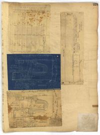
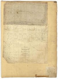
Page 109 of the City Engineer's Plat Book with six plats. Plat 1 shows lots located near the intersection of Exchange Street and Champney Street. Plat 2 shows lots and some buildings located on Church Street. Plat 3 shows lots located along Elliott Street, between East Bay and Church Street. Plat 4 shows lots and structures located near the corner of Church Street and Atlantic Street. Plat 5 shows lots and structures located near the corner of Church Street and Atlantic Street. Plat 6 shows lots and structures located near the intersection of East Bay Street and Guignard Street.
Page 11 of the City Engineer's Plat Book with five plats. Plat 1 shows a plot of land on the Charleston Harbor located near the intersection of East Bay Street and Queen Street. Plat 2 shows lots located between Conin Creek and King Street, and between Vanderhorst Street and "Manigault alias Boundary Street." Plat 3 shows plots and buildings located near the intersection of Liberty Street and St. Philip Street. Plat 4 features a plots, including one belonging to the "German Lutheran Church," located between King Street and Archdale Street.
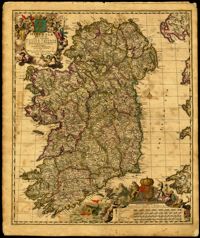
Decorative map of Ireland by Nicolaes Visscher (1649-1702). Impressive title cartouche with Pan and the Gaelic harp. Highly decorative scale of miles references William III, king of England, Scotland and Ireland 1689-1702. Visscher created this map shortly after William Petty's exhaustive survey of Ireland (the Down Survey) was published. Amsterdam. 52 x 62cm.
Page 110 of the City Engineer's Plat Book with three plats. Plat 1 shows lots located near the corner of Champney Street and Exchange Street, including labels for brick buildings, a label reading "EAST SHORE TERMINAL." Plat 2 shows lots and structures located near South Bay Street, between Church Street and Meeting Street. Plat 3 shows lots and some structures located near the intersection of Bogard Street and Percy Street.
Page 111 of the City Engineer's Plat Book with one plat. This plat shows lots located near the intersection of East Bay Street and Broad Street. It also shows a building labelled "EXCHANGE," and Gillon Street.
Page 112 of the City Engineer's Plat Book with five plats. Plat 1 shows lots and structures located on the north side of Tradd Street. Plat 2 shows lots located on the east side of Savage Street. Plat 3 shows lots located on King Street. Plat 4 shows lots located between Broad Street and Tradd Street, and between Lynch Street and the Ashley River. Plat 5 shows lots and structures located near the intersection of King Street and Broad Street.
Page 113 of the City Engineer's Plat Book with two plats. Plat 1 features "Shoal and Channel lots" located south of Tradd Street. Plat 1 also shows Gibbes Street, Council Street, two labels reading "ASHLEY RIVER EMBANKMENT," a line marking the edge of high land, a line marking the low water, and a line marking the edge of the channel. Plat 2 shows lots along New Street.
Page 114 of the City Engineer's Plat Book with elven plats. Plat 1 features lots located at the corner of King Street and Queen Street. Plat 2 shows a strip of land on the west side of King Street. Plat 3 shows lots along King Street. Plat 4 shows lots located near the intersection of Savage Street and Tradd Street. Plat 5 shows lots located on King Street. Plat 6 shows lots located near the intersection of King Street and Queen Street. Plat 7 shows lots located on King Street. Plat 8 shows a lot located on King Street. Plat 9 shows lots located near the intersection of South Bay Street and Legare Street. Plat 10 shows a lot on King Street. Plat 11 shows lots located near the intersection of Council Street and Gibbes Street.
Page 115 of the City Engineer's Plat Book with four plats. Plat 1 shows land located near Broad Street, Short Street, Franklin Street, and Queen Street. Plat 2 shows lots and structures located on King Street. Plat 3 shows lots and structures located on Franklin Street. Plat 4 shows lots and structures located on Queen Street.
Page 116 of the City Engineer's Plat Book with three plats. Plat 1 shows lots and structures located near the intersection of Meeting Street and Ladson's Court. Plat 2 features a proposed extension of Ladson's Court. Plat 3 shows lots located south of Tradd Street. Plat 3 also shows Gibbes Street, Council Street, a line marking the low water, and a line marking the edge of the channel.
Page 117 of the City Engineer's Plat Book with two plats. Plat 1 shows lots located near the Cooper River. Plat 2 shows marshlands, bodies of water, and lots located near the Ashley River.
Page 118 of the City Engineer's Plat Book with four plats. Plat 1 shows lots and structures on East Bay Street. Plat 2 shows lots along Meeting Street. Plat 3 shows lots located near the intersection of Inspection Street and Marsh Street. Plat 4 shows lots and structures along Anson Street, between George Street and Boundary Street.
Page 119 of the City Engineer's Plat Book with five plats. Plat 1 shows land located between East Bay Street and the Cooper River. Plat 1 also shows Trott Street, Hasell Street, Concord Street, and Pinckney Street. Plat 2 features Bennett's Rice and Lumber Mills, near East Bay Street. Plat 3 features a plot on East Bay Street. Plat 4 features lots and structures located near Church Street and Market Street, and shows a lot labelled "Gas Company." Plat 5 shows lots located near the intersection of East Bay Street and Lodge Alley.
Page 12 of the City Engineer's Plat Book with two plats. Plat 1 shows plots near Coming Street, St. Phillip Street, King Street, Meeting Street, and Vanderhorst Street. Plat 2 Shows lots on Queen Street near the intersections with East Bay Street and Prioleau Street, has the label "Charleston Harbour Cooper River" on the right-hand margin.
Page 120 of the City Engineer's Plat Book with five plats, labelled two through six. Plat 2 shows lots and buildings located near Cumberland Street, between Church Street and Philadelphia Street. Plat 3 shows lots located near the intersection Pinckney Street and Anson Street. Plat 4 shows lots and structures located on Hasell Street. Plat 5 shows lots and buildings along East Bay Street. Plat 6 shows lots and structures located between wharf street and the Cooper River.
Page 121 of the City Engineer's Plat Book with six plats. Plat 1 shows lots located near the intersection of Washington Street and Society Street. Plat 2 shows lots located on East Bay Street. Plat 3 shows lots and structures located near the intersection of Wall Street and Minority Street. Plat 4 shows lots located between Concord Street and Wharf Street. Plat 5 shows lots and buildings on Cumberland Street. Plat 6 shows lots and structures located on and near Broad Street.
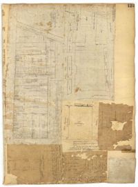
Page 122 of the City Engineer's Plat Book with three plats. Plat 1 shows lots and structures on Meeting Street. Plat 2 shows lots and structures located near the intersection of Anson Street and Laurens Street. Plat 3 shows lots located between Moultrie Street and Huger Street, near Rutledge Avenue.
Page 123 of the City Engineer's Plat Book with six plats. Plat 1 shows lots and structures located on and near Calhoun Street, between Anson Street and Meeting Street. Plat 2 shows lots and structures located between East Bay Street and Cooper River. Plat 3 shows lots and buildings located near Meeting Street. Plat 4 shows lots near a road, and has a large hole in the middle. Plat 5 shows lots and buildings located on Beaufain Street. Plat 5 shows lots located near an intersection, and has several holes in the paper.
Page 124 of the City Engineer's Plat Book with one plat. The plat features several lots and structures located on and near King Street, with one labelled "Theatre Lot."
Page 125 of the City Engineer's Plat Book with seven plats. Plat 1 shows several measurements for a structure. Plat 2 shows the line of division between St. Mary's Church Yard and the "Property of Mrs. Anna D. Fleming." Plat 3 shows two wharves. Plat 4 shows lots and structures near wharf street. Plat 5 shows lots near the intersection of Washington Street and Laurens Street. Plat 6 shows lots between Rose Lane and Market Street, near where they intersect with East Bay Street. Plat 7 shows lots between Congress Street and Race Street, near Rutledge Street.
Page 126 of the City Engineer's Plat Book with three plats. Plat 1 shows lots and structures located between George Street and Boundary Street, and between Meeting Street and Scarborough Street. Plat 2 shows lots on Anson Street, with one building labelled "Palmetto Engine House." Plat 3 shows a large swathe of land, including marshes and streams. One stream is labelled "Vardells CK," and a line towards the right of the plat is labelled "North Eastern Rail Road." The streets on this plat include King Street, Hampton Street, Moultrie Street, Meeting Street, America Street, Bay Street, Stewart Street, Cooper Street, and Line Street.
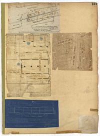
Page 127 of the City Engineer's Plat Book with four plats. Plat 1 shows lots and wharves, including Accommodation Wharf and Brown's Wharf. Plat 2 shows structures on Anson Street. Plat 3 shows lots located near the intersection of Pinckney Street and Anson Street. Plat 4 shows lots located on and near Gadsden Street, between Pinckney Street and King Street.
Page 128 of the City Engineer's Plat Book with one plat. The plat shows a city block between Meeting Street and Church Street, and between Cumberland Street and Market Street. A label reads "Champion Cotton Press Co. Lots," and another reads "Tudor Ice House."
Page 129 of the City Engineer's Plat Book with four plats. Plat 1 shows lots between Hayne Street and Market Street, near where they intersect with Meeting Street. Plat 2 features a lot and structures located along Meeting Street, between Hayne Street and Market Street. Plat 3 features a lot located on the "Charleston Harbour on Cooper River." Plat 3 also shows a wharf and other structures. Plat 4 shows the same area as Plat 3.
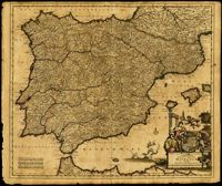
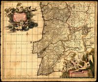
Map of Portugal and Algarve by Johannes de Ram (1648-1693). The title cartouche in the upper left depicts cherubs holding the Portuguese coat of arms; a note within the cartouche explains that the longitudinal lines on the map are based from the prime meridian that runs through Tenerife in the Canary Islands. The scale cartouche in the lower right features Neptune with a trident and two cherubs holding the coat of arms of Algarve, then a semi-autonomous region of Portugal. Amsterdam. 52 x 62cm.
Page 13 of the City Engineer's Plat Book with five plats. Plat 1 features plots on East Bay Street between Tradd Street and Broad Street (which is labelled in the top-left corner), including several wharfs. Plat 2 shows lots located between Archdale Street and King Street, including a plot belonging to the "German Lutheran Church." Plat 3 features a plot of land located on King Street. Plat 4 shows plots located on State Street between Market Street and Amen Street. Plat 5 features "Potters Field Public Cemetery," located near President Street and Congress Street.
Page 130 of the City Engineer's Plat Book with three plats. Plat 1 shows lots located on a city block between Meeting Street and Scarborough Street and between Boundary Street and George Street. Plat 2 shows lots and structures located on East Bay Street. Plat 3 shows lots located on the Cooper River channel of the Charleston Harbor, near Concord Street and Wharf Street.
Page 131 of the City Engineer's Plat Book with three plats. Plat 1 shows lots and structures located on George Street. Plat 2 features a lot on Rutledge Street. Plat 3 shows lots located on King Street, near its intersection with Clifford Alley.
Page 132 of the City Engineer's Plat Book with two plats. Plat 1 features a plan for the College of Charleston, showing buildings labelled "Charleston College," "Library," "Lodge," and "Charleston Orphan House." Streets on this plat include George Street, Smith Street, College Street, Calhoun Street, St. Philips Street, and Vanderhorst Street. Plat 2 shows lots located near the intersection of Montague Street and Lynch Street.
Page 133 of the City Engineer's Plat Book with one plat. The plat features Colonial Lake, located between Broad Street and Beaufain Street, and between Rutledge Street and Lynch Street.
Page 134 of the City Engineer's Plat Book with eleven plats. Plat 1 shows lots and structures located on Lynch Street. Plat 2 shows a lot located on Wentworth Street, with a building labelled "Charleston Engine House." Plat 3 shows lots located near the intersection of Calhoun Street and Ogier Street. Plat 4 shows lots located on Ogier Street. Plat 5 shows lots located on Ogier Street, near its intersection with Calhoun Street. Plat 6 shows lots located along Clifford Alley, near where it intersects with Archdale Street. Plat 7 shows lots located near the intersection of Calhoun Street and Ogier Street. Plat 8 shows lots located near the intersection of Vanderhorst Street and Ogier Street. Plat 9 shows lots located near the intersection of Calhoun Street and Ogier Street. Plat 10 shows lots located on and near Boundary Street, near where it intersects with St. Philips Street. Plat 11 features a lot owned by "The Unitarian Church," located on the intersection of Archdale Street and Clifford Alley.
Page 135 of the City Engineer's Plat Book with seven plats. Plat 1 shows lots on a city block located between Bennett Street and Calhoun Street, and between Rutledge Street and Lynch Street. Plat 2 shows a lot labelled "Cannon's Mall," located on the intersection of Calhoun Street and Rutledge Street. Plat 3 shows lots located on Meeting Street. Plat 4 shows the same lot as Plat 2. Plat 5 shows a lot located on King Street. Plat 6 shows lots and structures located on King Street, including a graveyard, a Meeting House, and a kitchen.
Page 136 of the City Engineer's Plat Book with seven plats. Plat 1 shows lots and structures located on and near the intersection of Liberty Street and St. Philips Street. Plat 2 shows lots located on Archdale Street, near Bennett's Mill Pond. Plat 3 shows lots and structures located on and near the intersection of Rutledge Street and Montague Street. Plat 4 shows lots and structures located on Archdale Street, including a building labelled "Hope Engine House." Plat 5 shows a lot located along Clifford Alley, near a lot labelled "Unitarian Church." Plat 6 shows lots located along King Street. Plat 7 shows lots located on and near Calhoun Street, located between Smith Street and Rutledge Street.
Page 137 of the City Engineer's Plat Book with six plats. Plat 1 shows lots located on and near Mazyck Street, between Short Street and King Street. Plat 2 shows lots located on and near the intersection of Pitt Street and Montague Street. Plat 3 features a lot located on the intersection of Archdale Street and Berresford Street. Plat 4 features a lot located at the intersection of Queen Street and Meeting Street. Plat 5 shows a lot located at the intersection of Queen Street and King Street. Plat 6 shows lots located on and near the intersection of Mazyck Street and Magazine Street, including one labelled "Roper Hospital Lot."
Page 138 of the City Engineer's Plat Book with three plats. Plat 1 features a lot located on Hasell Street, with a large building labelled "St. Mary's Church." Plat 2 shows lots and structures located between Rutledge Street and Trapmann Street, and between Queen Street and Broad Street. Plat 3 features a lot located on Radcliffe Street, between Rutledge Street and Smith Street.
Page 139 of the City Engineer's Plat Book with five plats. Plat 1 shows a lot and structures located at the corner of Calhoun Street and Alexander Street. Plat 2 shows lots located on Queen Street, near where it intersects with Back Street. Plat 3 shows lots located on and near Mazyck Street, near its intersection with Magazine Street. Plat 3 also shows lots labelled "Roper Hospital Lot," and "City Lot." Plat 4 shows lots located between Vanderhorst Street and Boundary Street, and between Coming Street and Pitt Street.
Page 14 of the City Engineer's Plat Book with one plat. The plat shows land between Bay Street and Church Street, including stretches of Tradd Street, Broad Street, and Queen Street.
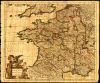
Map of France by Justus Danckerts (1635-1701) includes Belgium and Luxembourg and parts of Switzerland, the Netherlands, Germany and England. Title cartouche depicts a Roman soldier and other allegorical figures. Amsterdam. 52 x 62cm.
Page 140 of the City Engineer's Plat Book with six plats. Plat 1 shows lots and structures located on and near Queen Street, between King Street and Meeting Street. Plat 2 shows lots located on Rutledge Street. Plat 3 shows lots located between George Street and Burns Lane, near where they intersect with Meeting Street. One lot is labelled "Property of Charleston High School." Plat 4 shows lots and structures located between Lynch Street and the Ashley River, near Broad Street and Beaufain Street. Plat 5 shows lots and structures located on the corner of King Street and Society Street. Plat 6 shows the same area as Plat 5, but with some changes to the structures.
Page 141 of the City Engineer's Plat Book with four plats. Plat 1 features a lot and structures located between Lynch Steet and the Ashley River, near Broad Street. It also shows Comings Creek, a pond, and a lot labelled "Clark & Steinmeyer." Plat 2 shows lots and structures located near the intersection of College Street and Calhoun Street. Plat 3 shows a lot and structures in "the City of Charleston in Ward No. 9." Plat 4 shows lots on and near Society Street, between Meeting Street and King Street.
Page 142 of the City Engineer's Plat Book with four plats. Plat 1 shows lots and structures located on the corner of Meeting Street and Burns Lane, with one lot labeled "Property of Charleston High School." Plat 2 shows lots located on Pitt Street. Plat 3 shows lots and structures located on Pitt Street. Plat 4 shows land located between Broad Street and Wentworth Street, and between Lynch Street and the Ashley River. Plat 4 also shows a line labelled "Low Water Mark of Ashley River," Comings Creek, and a "City Mud Flat, lying North of Creek."
Page 143 of the City Engineer's Plat Book with two plats. Plat 1 shows land located near the intersection of Washington Street and Chapel Street, with two wharfs and the "site of the creek in 1801." Plat 2 shows lots and structures located on the west side of Washington Street.
Page 144 of the City Engineer's Plat Book with five plats. Plat 1 shows lots on and near the Cooper River channel, near Boundary Street, Charlotte Street, Washington Street, and Alexander Street. Plat 1 also shows a creek and a stretch of marshland. Plat 2 shows lots located near the intersection of South Street and America Street. Plat 3 features structures located on the intersection of South Street and America Street. Plat 4 shows lots and structures located at the intersection of President Street and Cannon's Court. Plat 5 shows lots located between Drake Street, America Street, and Alexander Street.
Page 145 of the City Engineer's Plat Book with seven plats. Plat 1 shows lots located on Chapel Street, near where they intersect with Alexander Street. Plat 2 shows lots and structures located on South Street, near where it intersects with another street. Plat 3 shows lots located along Anson Street, near where it intersects with Calhoun Street. Plat 4 features lots located on the "Eastern end of Wraggs" Street. Plat 4 shows lots and structures located between Concord Street and Wharf Street, near where they intersect with Inspection Street. Plat 5 features a strip of land belonging to the Charleston Gas Light Company, located near Concord Street. It also shows a "Train-way" and a building labelled "Gas Works." Plat 7 shows lots and structures located between Line Street and Sheppard Street.
Page 146 of the City Engineer's Plat Book with three plats. Plat 1 shows lands located on and near the intersection of East Bay Street and Hasell Street. Plat 2 features a lot located on the north side of John Street, between Meeting Street and King Street. It also shows a lot labelled "So. Ca. RR. Co." Plat 4 shows a park and buildings located between King Street and Meeting Street, and between Calhoun Street and Hutson Street.
Page 147 of the City Engineer's Plat Book with three plats. Plat 1 shows lots located between King Street and land owned by the South Carolina Railroad Company. Plat 2 shows lots and structures located between Charlotte Street and Calhoun Street, and between Washington Street and Meeting Street. It also shows Alexander Street, Elizabeth Street, and Henrietta Street. Plat 3 shows lots and structures located on and near the intersection of President Street and Cannon's Court.
Page 148 of the City Engineer's Plat Book with two plats. Plat 1 shows lots and structures located on and near Calhoun Street, between Washington Street and the Cooper River. Plat two shows "Lots in the Village of Rikersville," including 21 acres of marshland, a canal, and a pond.
Page 149 of the City Engineer's Plat Book with one plat. The plat shows lots located between Meeting Street and King Street, including a stretch of railroad.
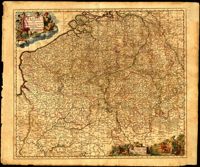
Map of Belgium by Nicolaes Visscher (1649-1702) with Luxembourg and parts of France, the Netherlands and Germany. Title cartouche in upper right corner shows resting warriors and cherubs. A harvest scene surrounds the scale in the lower left corner. Amsterdam. 52 x 62cm.
Page 15 of the City Engineer's Plat Book with three plats. Plat 1 features plots located between Rutledge Street and Smith Street, near the intersections with Queen Street. Plat 2 features a lot on the corner of Tradd Street and Savage Street. Plat 3 shows the intersection of Calhoun Street and Rutledge Avenue (also labelled as Rutledge Street) with proposed changes.
Page 150 of the City Engineer's Plat Book with five plats. Plat 1 shows lots located between President Street and the Ashley River, and between Spring Street and Mill Street. It also shows an "Ashley River Bridge" on Spring Street, and a lot labeled "Charleston and Savannah R.R." Plat 2 shows lots and structures located on the west side of Rutledge Avenue. Plat 3 features a lot located on the corner of St. Philips Street and Calhoun Street. Plat 4 shows lots located on the east side of Rutledge Avenue. Plat 5 shows lots and structures located on King Street, including labels reading "Upper Police Station" and "Cistern Underground."
Page 151 of the City Engineer's Plat Book with two plats. Plat 1 shows lots and structures located on and near Anson Street. Plat 2 shows lots and structures located between Coming Street and the Ashley River Channel, and between Elliott Street and Mill Creek. The plat also shows 50 acres of marsh, several bodies of water, Boundary Street, Pinckney Street, Cannon Street, and President Street.
Page 152 of the City Engineer's Plat Book with three plats. Plat 1 shows lots and structures located on King Street. Plat 2 shows lots located on Luhn's Court, near where it intersects with Smith Street. Plat 3 shows lots and structures located on and near the intersection of Morris Street and King Street.
Page 153 of the City Engineer's Plat Book with three plats. Plat 1 shows lots located between Rutledge Street and Lynch Street, near where they intersect with Calhoun Street. Plat 2 shows lots located on and near the intersection of Rutledge Avenue and a private court. Plat 3 shows lots located between Smith Street and Ogier Street, near where they intersect and Vanderhorst Street.
Page 154 of the City Engineer's Plat Book with three plats. Plat 1 shows lots and structures located between Radcliffe Street and Warren Street, near where they intersect with Coming Street. Plat 2 shows lots and structures located between Thomas Street and Smith Street. Plat 3 shows lots and structures located near the intersection of St. Philips Street and Vanderhorst Street. Plat 3 also includes labels reading "Kitchen building," and "Lot of the Irish Volunteers."
Page 155 of the City Engineer's Plat Book with three plats. Plat 1 features a tract of land located between Calhoun Street and Bennett Street, and between Lynch Street and Rutledge Street. Plat 2 shows lots and structures located on Vanderhorst Street. Plat 3 shows lots and structures located on St. Philips Street.
Page 156 of the City Engineer's Plat Book with five plats. Plat 1 shows lots and structures located on the east side of Rutledge Street. Plat 2 features a lot located on the intersection of Coming Street and Warren Street. Plat 3 shows lots and structures located on Morris Street. Plat 4 shows lots and structures located on King Street. Plat 4 shows lots and structures on and near the intersection of Calhoun Street and Lucas Street.
Page 157 of the City Engineer's Plat Book with two plats. Plat 1 features a lot of land located on the South Side of Line Street. Plat 2 shows lots located on and near the intersection of Spring Street and Kracke's Court.
Page 158 of the City Engineer's Plat Book with four plats. Plat 1 shows lots located on South Street, near where it intersects with Hanover Street. Plat 2 shows lots located on and near Mill Street, near its intersections with Lucas Street and President Street, and shows a building labelled "Dead House" and a creek labeled as "leading to canal." Plat 3 shows lots and structures located on East Bay Street. Plat 4 shows South Bay Street and its intersections with Legare Street and King Street.
Page 159 of the City Engineer's Plat Book with five plats. Plat 1 shows lots and structures located on East Bay Street, between Hasell Street and Cumberland Street. Plat 2 features a lot located on King Street, between Hudson Street and Tobacco Street. Plat 3 shows lots located between State Street and East Bay Street, located near their intersections with Market Street. Plat 4 shows lots located along "Horlbecks Alley," between King Street and Meeting Street. Plat 5 shows lots located on Short Street, between Mazyck Street and Franklin Street.
This map by Theodore Danckerts (1663-1727) details the bishoprics of Liege, Cologne and Trier and the duchies of Berg and Julich. Map covers the area surrounding the Meuse, Rhine and Moselle rivers and includes parts of modern day Belgium, the Netherlands, Germany, Luxembourg and France. Decorative title cartouche with putti holding the shields of the regions. Amsterdam. 52 x 62cm.
Page 16 of the City Engineer's Plat Book with five plats. Plat 1 shows lots close to the Ashley River located near Tradd Street and Gibbes Street, including a marsh flat labelled as "City Lands." Plat 2 shows lots located near the intersection of Tradd Street and Council Street, including "City marshlands." Plat 3 shows lots located near Gibbes Street and South Bay Street, and includes a dotted line labelled "Low Water Mark." Plat 4 shows land located between Ellery Street and Old Church Street, including a stretch of Raper Street. Plat 5 shows land near the intersection of South Bay Street and "Legare or Johnson Street," and close to the "Low Water" of the Ashley River.
Page 160 of the City Engineer's Plat Book with four plats. Plat 1 shows a stretch of Mazyck Street, near its intersections with Queen Street and Short Street. Plat 2 shows lots and structures located on and near Reid Street, between Drake Street and Bay Street. Plat 4 shows lots and structures located between Nassau Street and Meeting Street, and between Stewart Street and Johnson Street.
Page 161 of the City Engineer's Plat Book with two plats. Plat 1 shows lots located near the intersection of South Street and Drake Street, and also shows America Street. Plat 2 shows a "Plan of Hampstead," which shows Meeting Street, a public square, Blake Street, Drake Street, Bay Street, Amherst Street, Reid Street, and Reid Street.
Page 162 of the City Engineer's Plat Book with three plats. Plat 1 shows land located near Payne Street with several streams. Plat 2 shows lots located in the Village of Hampstead, located near America Street. The plat also shows marshland and streams. Plat 3 has numerous tears and holes. Plat 4 shows lots and structures located between Meeting Street and Lynch Street.
Page 163 of the City Engineer's Plat Book with two plats. Plat 1 shows lots and structures located on Friend Street, near its intersections with Queen Street, Broad Street, and an unlabeled street. Plat 2 shows lots located on King Street, near where it intersects with Broad Street.
Page 164 of the City Engineer's Plat Book with three plats. Plat 1 shows lots located between Meeting Street and Aiken Street, and between Cooper Street and Line Street. Plat 2 shows lots located on Felix Street. Plat 3 shows lots located on Grove Street, and shows a stream and a label reading "Frenchman's Hill."
Page 165 of the City Engineer's Plat Book with three plats. Plat 1 shows lots located near a "Public Road from and to Charleston." It also shows marsh land, a fishpond, and a garden. Plat 2 shows land located near the intersection of America Street and Brigade Street. Plat 3 shows lots located near the intersection of Meeting Street and Riker Street, including a stretch of land labeled "Low Ground."
Page 166 of the City Engineer's Plat Book with five plats. Plat 1 shows lots and structures located near the intersection of Columbus Street and Meeting Street. Plat 2 features lots located along Moultrie Street, between Meeting Street and Russel Street. Plat 2 also shows King Street and Hampton Street. Plat 3 shows lots located between Meeting Street and a line labeled "South Carolina R. R. Company," near Romney Street, Addison Street, and Poinsett Street. Plat 4 shows a lot located on the north side of Amherst Street. Plat 5 shows lots located near the intersection of Bay Street and Blake Street.
Page 167 of the City Engineer's Plat Book with two plats. Plat 1 shows lots located between Meeting Street and a line labelled "So. Ca. R. R." Plat 2 shows lots located between Moultrie Street and Line Street, and between America Street and Meeting Street. Plat 2 also shows lots between Hampton Street and Moultrie Street, West of Meeting Street.
Page 243 of the City Engineer's Plat Book with three plats. Plat 1 features lots along Cumberland Street, near where it intersects with State Street. The second plat features "City Lands West of President Street and South of Congress Street." It also labels reading "Old Folks Holme," "Grave Yard Old Folks Home," "City Board of Public School Commissioners," and "Colored Industrial School." Plat 3 shows lots located west of Meeting Street, and also shows Cooper Street, Lee Street, Sheppard Street, and Sumter Street.
Page 244 of the City Engineer's Plat Book with three plats. Plat 1 shows lots and structures located along Maple Street, near where it intersects with Meeting Street. Plat 2 features a lot located on the east side of Tenth Street, between St. Margaret Street and Grove Street. Plat 3 shows land located near the intersection of State Street and Cumberland Street.
Page 246 of the City Engineer's Plat Book with one plat. The plat shows lots located between Rutledge Avenue and the Ashley River. Groups of lots are labelled with red letters. The plat also shows Darlington Avenue, Ashley Avenue, Piedmont Avenue, Hester Street, Clemson Street, Maple Street, Peachtree Street, Poplar Street, Pendleton Street, and Sans Souci Street.
Page 251 of the City Engineer's Plat Book with two plats. Plat 1 shows Meeting Street, Williman Street, and Romney Street. Plat 2 shows lots located on and near America Street, Lee Street, Cooper Street, and Drake Street.
Page 257 of the City Engineer's Plat Book with two plats. Plat 1 shows lots located between St. Margaret Street and Grove Street. Plat 2 shows lots located along Marsh Street and Concord Street, near where they intersect with Laurens Street.
Page 255 of the City Engineer's Plat Book with two plats. Plat 1 features lots located between St. Margaret Street and Grove Street, and between Tenth Street and Eleventh Street. Plat 2 features lots and structures located on the intersection of Aiken Street and Hampden Court.
Page 250 of the City Engineer's Plat Book with one plat. The plat shows lots between Romney Street and Williman Street, and east of Meeting Street. The plat also shows Isabella Street.