Plat includes Langley Branch Road going through plat as well as a road. Plat consists of 200 acres. Names associated with this plat are Mary Manlt, William Manlt, William Postell, Patrick Neel, Ralph Izard, Thomas Clark, A. Darby, Amoldus Vanderhorst, Margaret Manlt and W.S. Smith. Notable geographic locations include St. George’s Parish, Langley Branch, Cypress Road, Dorchester, Cypress Swamp, and Charleston District.
FRONT: Plat is on the northside of the Ashley River. Contains 200 acres. BACK: Plat contains 36 acres on the North side of the Ashley River. Names associated with this plat are Richard Baker, Elibee Baker, John Baker, Josiah Baker, John Guptan, James Cantley [?], James Glen, John Stevens, Joseph Child, John Ainslee, Richard Baker, William Cattell and George Hunter. Notable geographic locations include St. George's Parish, Ashley River and Berkeley County.
Copy of a plan annexed to a deed for 177 acres given by Ebenezer Simmons to the John's Island Society lying adjoining the church on Johns Island. Names associated with this plat are Johns Island Society, Ebenezer Simmons, James Lawson, Robert Gibbes, William Boone, John Freer, George Scott, Thomas Smith, Daniel Doyley, Joshua Ward, John Hanyon, John Moultrie, Isaac Wraught, and John Stanyarn.
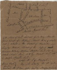
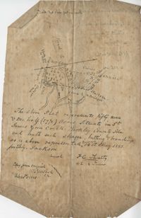
Plat contains 59 (1/2) acres. Plat contains the road to Ladson running west to east through the property the plat also includes the location of the house as well as the brickyard. Names associated with this plat include E.J. Jackson, M. Brailsford, Caines, Edon, F.C. Shutty and W.B. Guerard. Notable geographic locations include St. James Parish and Goose Creek.
Copy of a plan of a plantation or tract of land lately sold to Isaac Holmes by James Legare lying on Johns Island, Charleston District from a plan annexed to Arleas from Thomas Legare and annexed to Isaac Holmes 1784. 380 acres. Names associated with this plat are Thomas Legare, James Legare, and Isaac Holmes. Notable geographic locations include Charleston District and Johns Island.
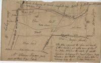
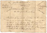
250 acre plot given to Peter Lesesne on the 20th of February 1760, butting and bounding on the south side of the Santee River. Names associated with this plat are Peter Lesesne, James Thomson, Peter Robert, Joseph Manap [?], and Phippes.
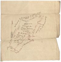
1300 acres surveyed for James Bowman, no land type or detail, shows property boundaries and neighboring plots. Names associated with this plat are James Bowman, Morris, Oswald, Warley, E.B. Fishburn, Lindsey, and B.G.O. Bryan. Notable geographic locations include New road leading to Parkers Ferry [?].
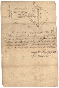
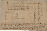
Resurvey of a tract of land measuring 510 acres called Egan Hall belonging to John Egan situated in St. James Parish, Santee. Names associated with this plat are John Egan, Gredless and Ball. Notable geographic locations include St. James Parish, Santee, Egan Hall, and Bunker's Hill.
180 plot of land given to Elisa [Pennison], shows the budding and bounding of neighboring plantations with no land type or detail. Names associated with this plat include Thomas Pennison, Elisa Pennison, C. Perriman, Thads, Smith and Charles Grady.
Plat of 500 acres in Craven County on the Pee Dee River annexed to the original 40,000 acres orginally granted to Landgrave Robert Daniel. Names associated with this plat are Robert Daniel, Robert Gibbs, the Lords Proprietors, Thomas Broughton and Waring. Notable geographic locations include the Pee Dee River, Craven County [now in parts of Berkeley, Charleston, Georgetown, and Williamsburg counties], Sawhee, Beedee, and Georgetown District.