Pee Dee River Plat 1711

Close Viewer
- Title:
- Pee Dee River Plat 1711
- Date:
- 1711
- Description:
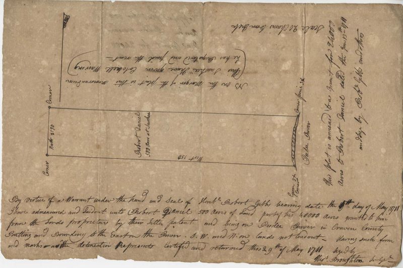
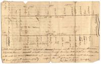
- Plat of 500 acres in Craven County on the Pee Dee River annexed to the original 40,000 acres orginally granted to Landgrave Robert Daniel. Names associated with this plat are Robert Daniel, Robert Gibbs, the Lords Proprietors, Thomas Broughton and Waring. Notable geographic locations include the Pee Dee River, Craven County [now in parts of Berkeley, Charleston, Georgetown, and Williamsburg counties], Sawhee, Beedee, and Georgetown District.
- Collection Title:
- John McCrady Plats and Deeds Collection
- Contributing Institution:
- South Carolina Historical Society
- Media Type:
- Maps
- Topical Subject:
- Conveyancing--South Carolina, Maps, and Surveying--South Carolina
- Geographic Subject:
- Pee Dee River (N.C. and S.C.)
- Language:
- English
- Shelving Locator:
- 510.00, Box 3, Folder 31
- Date Digital:
- 2017-02-24
- Digitization Specifications:
- 400 dpi, 24-bit depth, color, Bookeye 4 Basic, Archival masters are tiffs.
- Internet Media Type:
- image/jpeg
- Copyright Status Statement:
- Public Domain.
- Access Information:
- For more information and re-use requirements contact the South Carolina Historical Society, Charleston, SC, 29401.
- Admin ID:
- 223313
Permalink