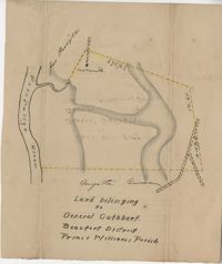
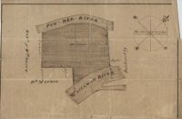
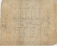
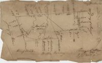
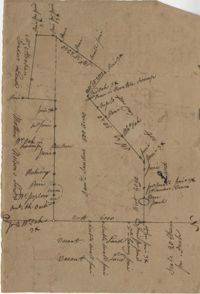
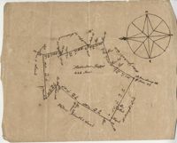
Plat of land belonging to General Cuthbert in the Beaufort District on the Pocotaligo River. Little other detail included in the plat besides the property lines and the river. Names associated with this plat include Luna Cuthbert and Cuthbert.
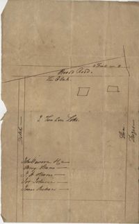
500 acres surveyed for Thomas Ditom now Paul Blare. Includes Bacon Bridge Road. Names associated with this plat are Paul Blare, Dilton, William Way and Scotte.
Plat of Hopewell Plantation with surrounding lands owned by several people, shows the Edisto River and an unnamed settlement, labels the land in the center as uncleared land while swamps, roads, rivers and trees surround it. Acreage unclear. Names associated with this plat are Baring, Branford, Mellechamp, Colonel W. Hayne and Arthur Middleton. Notable geographic locations are St. Paul's Parish, Edisto River, and Willtown Road.
Plat of two tracts of land (1000 acres) adjoining each other on the north side of the Santee River now belonging to the estate of Brown. Copy from the plat annexed to the orginal grants from the Lords Proprietors. Names associated with this plat are Peter Gaillard, Brown, Henry Bruneau and The Lords Proprietors. Notable geographic locations include the Santee River and Dohov Swamp and Creek.
Three separate 211 acre plots (633 total) of land that are budding and bounding on the south side by the Santee River, shows some trees at the property border and surrounding neighbors. Names associated with this plat are Major Ladson and William Moultrie. Notable geographic locations include the Santee River.
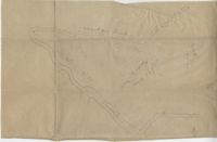
Sketch of land with no measurements or names, shows some trees and unnamed road/creeks. Names associated with this plat are John Michael and J.H. Alston. Notable geographic locations include Santee River and St. James Parish.
Plan of 101 acres in St. James Parish, Goose Creek belonging to Abram Jones. Details include roads, ports, banks, trees and a field. Names associated with this plat are Abram Jones, Thomas Middleton, and Major Benjamin Smith. Notable geographic locations include Goose Creek, Charleston District, and Black River Road.
161 acres of land southeast of Pee Dee River. Details include rivers, a canal, and trees. Names associated with this plat are Mackie and William Stitt. Notable geographic locations include Waccamaw River and Pee Dee River.
Tract of land belonging to May Ball in area known as Three Mile Head. Names associated with this plat are John Ball, Huger, Gourdin, E. Ball, May Ball and Caw. Notable geographic locations include Three Mile Head and Tartleberry.
Tract of land containing 416 acres. Details include trees, surrounding land, water, and roads. Notable geographic locations include St. John's Parish and Berkeley.
Two parcels of land (A & B) on the south side of the south branch of the Santee River in St. James Parish, Charleston District. Names associated with this plat include Rebecca Motte and Jonah Collin. Notable geographic locations include Washo Plantation, St. James Parish, Santee and Charleston District.
Copy of a plat of 150 acres and granted to Jobe Howes now forming part of Hickory Hill plantation in St. James Goose Creek and part in St. John and St. James Parish.
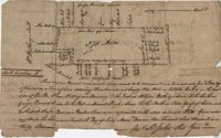
Plat of a part of Inverness sold from the estate of C. Huguenin to John Martin containing 538. Plat includes a railroad, a fort, a public road and fence. Names associated with this plat are C. Huguenin, John Martin, William Heyward, and Gunie [?]Williams. Notable geographic locations include Inverness and Pocotaligo Bridge.
876 acre plot for Simpson, shows roads, houses, and rivers/creeks, no names on any of the details, includes surrounding tracts of lands and trees on the property boundaries. Names associated with this plat are Simpson, Keith, James Gray Wiase, and Charles Johnston.
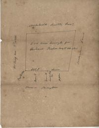
500 acres of land surveyed for Richard Bedon. Details are minor and include trees and surrounding lands. Names associated with this plat are Broughton, Archibald Smith, May Postell and Richard Bedon. Notable geographic locations include Dorchester and St. George's Parish.
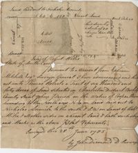
Plat of 640 acres of land belonging to Thomas Roberts situated in Berkeley County on the Cooper River bounding to the North and NE on land lad out to Nicholas Aremile to the south and SW on lands of Robert Miles and all other sides on vacant land. Names associated with this plat are John Berry, Ephraim Mitchell, Thomas Roberts, Nicholas Roberts, Nicholas Aremile, Robert Miles, William Gilbert, Barfield Homan and John Diamond. Notable geographic locations include the St. John's Parish, Cooper River, Berkeley County and Charleston District.
Plat of land laid out to Huggins of 58 acres situated on the NE side of Pee Dee River butting and bounding to the North on William Alston's land and to the south and southwest on unknown land. Names associated with this plat are Huggins, William Alston, Job Roshmahler and John Hardwick.
Plat includes 500 acres on the Cypress Swamp. Names associated with this plat are James Sanders, Matthew Nelson, William Abraham, Abraham Sanders, and Samuel Sanders. Notable geographic locations include St George’s Parish, Cypress Swamp, Dorchester, and Thorntree Swamp.
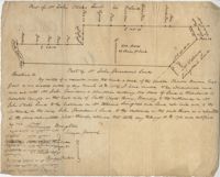
A quarter of an acre including a church on Marsh Field Plantation. Names associated with this plat are Thully T.G. Beneyor, Frederick Smith, J.G. Sturly, Rebecca Bennett and Rantowle. Notable geographic locations include St. Andrews Parish, Marsh Field Plantation, and Road to Rantowle's Ranch.
Plat of two tracts of land one for 360 acres and the other for 90 plat contains dates and names of the properties as well as a short chain of title. Names associated with this plat are John Musgrove, John Champneys, Sarah Champneys, William Stend, Robert Adams, George Jackson, Thomas Grumball, Sherriff C.D Elliott, Jabina, Col. William Ball, William John Champney, William Seads, and James St. John. Notable geographic locations include the Edisto River, Hickory Bridge and Colleton County.
Sketch of lots near Dorchester now belonging to James Kennedy. Names associated with this plat are James Kennedy, Thomas Droger, John Dawson, M. Strom, J.H. Strom, J. Johnson, and J. Nilson. Notable geographic locations include Dorchester, St. George's Parish and Broad Road.
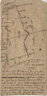
Plat of land belonging to Thobar butting and bounding 163 acres of land owned by Margaret Burger Master. Very little explanation of pertinent details on the plat. Names associated with this plat are Henry Thobhar, Margaret Burger Master, N. Winklin and J.L. Porcher.
Plat is laid out for 200 acres of land but when surveyor toured the land contained 547 acres apparently the surveyor did not "run the lines" properly when the land was first laid out and not setting corners. Names associated with this plat are Thomas Tucker, Archibald Crall, John Cook, Richard Ireland, Levey, John Linder, and James Stuard. Notable geographic locations include the Edisto River.
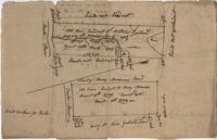
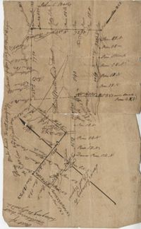
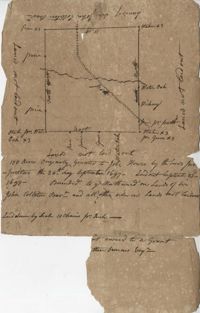
Plat of land belonging to General Cuthbert in the Beaufort District on the Pocotaligo River. Little other detail included in the plat besides the property lines, trees and the river. Names associated with this plat are Cuthbert Luna, Smith, Gordon [?], and Adam Jordan.
Plat laid out unto James St. John containing 375 acres of land in Colleton County. Names associated with this plat are James St. John, William Westbury, George Vincent, Samuel Sleigh, and John Godfrey. Notable geographic locations include Colleton County and the Pon Pon River.
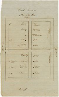
Plat of land with rice fields and highlands noted along with the neighboring properties. Very little other detail or explanation given. Names associated with this plat include Carson, Isaac Waight, and Ann Stanyarn.
Plan of 500 acres of land along Turtle Island. Notable geographic locations include St. Peters Parish, Turtle Island, Wrights River, Dawfuskie [Daufuskie] Sound, Black Oyster Point, and New River.
Copy of a plat part now belonging to Benjamin Perry and part to John Pringle on the west side of Ashley River. Names associated with this plat include John Pringle, Benjamin Perry, John Julius Pringle, Lambert Lance, Abraham Ladson, Sarah Rose, Nathaniel Bradwell, Ephraim Mitchell, Thomas Drayton, John Frazer, Frances Baker, Thomas Osborn, Isaac Landson, Isaac Perry, John Drayton, Glen Drayton, Francis Ladson and W. John Cattle. Notable geographic locations include the Ashley River, Charleston, Berkeley County, and Ashley River Road.
Plat contains 500 acres on the Edisto River. Names associated with this plat are William John Gerardeau, John Stock, William Livingston, Thomas Broughtors, Charles Craven, Charles Parker. Notable geographic locations include South Edisto River and Colleton County.
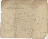
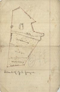
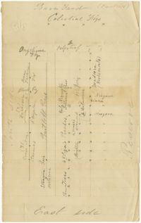
Unnamed plot of land that is divided into four parts, Santee swamp, ridge, Buck Swamp, and the section that includes a road and the house, no measurements or surrounding details. Names associated with this plat are G.S. Jayne.
Copy of plat of land being 903 belonging to Archer Smith in Georgetown District on the side of Pee Dee. Names associated with this plat are Archer Smith, Thomas Water, Abraham Livingston, J. Roshnakler, W. Glover, Preugh [?], Thomas Skrine [?], John J. Pringle, Alexander Roses and John Coates. Notable geographic locations include Pee Dee, Georgetown District, and Path to Black River from Pee Dee.
Plat of land with unknown acreage on Wadmalaw Island. Names associated with this plat include Gibbs, Wescot, and Benjamin Walter. Notable geographic locations include St. John's Parish, Wadmalaw Island, Colleton, and Public Road to Beau Bluff.
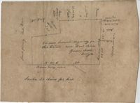
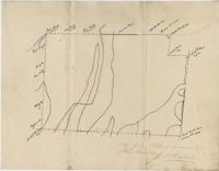
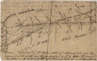
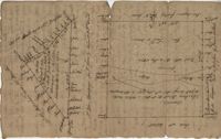
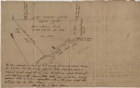
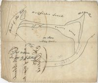
Plat of land near Pocotaligo. Very little information and explanation are included. The land looks to be near a crossroads and some form of water. Names associated with this plat are Cuthbert. Notable geographic locations include Augusta Road, Cossawhatchie [Coosawatchie], Pocotaligo, and Prince William's Parish.
Plat contains 1000 acres. Names associated with this plat include William Liott and David Celiphairch [?]. Notable geographic locations include St. George Parish.
58 acres of land laid out unto M. Belin situated on Sandy Island. Names associated with this plat are John Hardwick, Thomas Waring, Broughton and Postell.
Six maps conveying plans to beautify Ansonborough, showing the footprints of buildings and annotated to indicate the status of buildings, traffic flow, and scenarios that would result from the Ansonborough Rehabilitation Project.
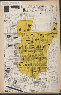
Hand-drawn and color-coded map of Ansonborough indicating properties purchased by HCF, restored by HCF, for sale by HCF, restored privately, and other distinctive antebellum houses. Created to illustrate HCF’s Ansonborough Rehabilitation Project.
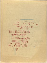
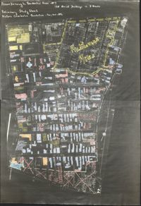
Copies of Sanborn Map pages combined to study maps of various areas in Charleston. Color-coded to depict building status. Second image provides key for color coding.
Map of Ansonborough showing Meeting Street, King Street, Hasell Street, Maiden Street, Old Church Street, Bay Street, and others. A small piece of paper taped to the back reads: "Kindness of: Mr. Gedney M. Howe."
Page 254 of the City Engineer's Plat Book with one plat. A "Plat of Wagner Terrace," showing numerous lots and Hampton Park. Streets shown include Dunneman Street, Grove Street, and Rutledge Avenue.