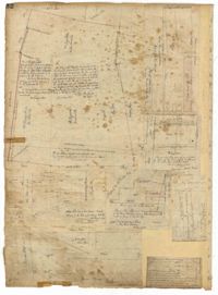
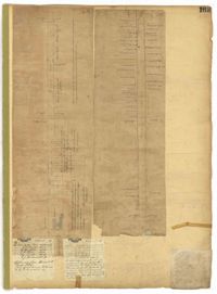
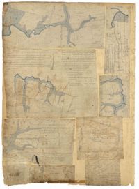
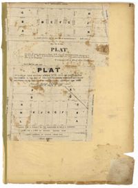
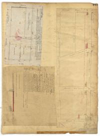
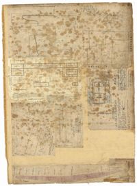
Page 66 of the City Engineer's Plat Book with fourteen plats. Plat 1 features buildings located near the intersection of King Street and Clifford Street. Plat 2 shows lots and structures located near the intersection of "Comings Street" and Wentworth Street. Plat 3 shows a lot and structures located on Pitt Street. Plat 4 shows lots located on a city block between Smith Street and Pitt Street, and between Montague Street and Wentworth Street. Plat 5 shows lots located on a city block between Montague Street and Wentworth Street, and between South Street and Rutledge Street. Plat 6 features a lot located near the intersection of "Comings Street" and Montague Street. Plat 7 shows lots and some structures located near the intersection of Bull Street and Coming Street. Plat 8 shows a lot and buildings located on Bull Street. Plat 9 Shows lots located near the intersection of Smith Street and Boundary Street. Plat 10 shows lots located on a city block between Lynch Street and Rutledge Street, and between Bull Street and Montague Street. Plat 11 shows lots and structures located near the intersection of Pitt Street and Bull Street. Plat 12 is features a lot located at the intersection of Pitt Street and Bull Street. Plat 13 Features lots located near the intersection of Bull Street and Lynch Street. Plat 14 shows lots located on Queen Street.
Page 62 of the City Engineer's Plat Book with eight plats. Plat 1 shows lots located near East Bay Street. Plat 2 shows a lot on Concord Street, including a wharf. Plat 3 shows three Wharf Lots on Wharf Street, near the intersection with Inspection Street. Plat 4 features a lot on Wharf Street with a dock and a brick building, across the street from a building labelled "Eagle Foundry." Plat 5 shows a lot with several buildings on East Bay Street. Plat 6 shows land near the intersection of East Bay Street and Cumberland Street, with a stretch labelled "Passage to what is now called Central Wharves." Plat 7 shows a wharf and yard on Concord Street, and a structure labelled "Cotton Shed on Brick Pillars." Plat 8 shows a lot located at the intersection of Anson Street and Calhoun Street.
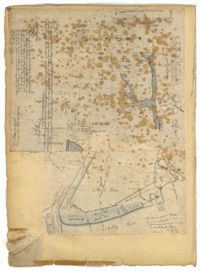
Page 65 of the City Engineer's Plat Book with six plats. Plat 1 shows wharves and other structures located near the intersection of East Bay Street and Elliott Street, and also shows a building labelled "Old Post Office." Plat 2 features a wharf on the Cooper River, and shows several structures. Plat 3 shows wharves and brick storehouses located near the intersection of Prioleau Street and Queen Street. Plat 4 shows lots near the intersection of Bull Street and Smith Street. Plat 5 shows lots and structures located near the intersection of King Street and Morris Street. Plat 6 shows land located along a stretch of Coming Street, between Race Street and Sumter Street.
Page 60 of the City Engineer's Plat Book with eight plats. Plat 1 shows lots near East Bay Street, and the intersection of Washington Street and Inspection Street. Plat 2 shows lots and a building located near Market Street. Plat 3 shows lots located between Washington Street and Marsh Street, and between Inspection Street and Calhoun Street. Plat 4 shows plots located on Market Street with a dotted line labeled "Line of Street proposed by the City." Plat 5 shows plots and structures located near East Bay Street. Plat 6 shows lots located near the intersection of Concord Street and Inspection Street. Plat 7 shows lots located near the intersection of Pinckney Street and East Bay Street. Plat 8 shows a dock and wharf on the Cooper River.
Page 68 of the City Engineer's Plat Book with eight plats. Plat 1 shows lots and some structures located near the intersection of Rutledge and Wentworth Street. Plat 2 features lots and some structures located near Bull Street, between Lynch Street and Gadsden Street, and has a label reading "Mill Pond." Plat 3 shows lots and buildings located near the intersection of Bull Street and Lynch Street. Plat 4 shows a city block between Wentworth Street and Beaufain Street, and Smith Street and Rutledge Street. Plat 5 shows lots located on Beaufain Street. Plat 6 features a lot located on "Comings Street," between Wentworth Street and Montague Street. Plat 7 shows a city block located between Wentworth Street and Montague Street, and Gadsden and Lynch Street. Plat 8 shows a city block located between Lynch Street and Rutledge Street, and Wentworth Street and Beaufain Street.
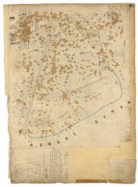
Page 74 of the City Engineer's Plat Book with four plats. Plat 1 shows lots and some buildings located near Line Street, between King Street and a "Rail Road Company Road." Plat 2 shows lots located along Amherst Street, including one labelled "Cemetery of the Evangelical German Lutheran Church." Plat 3 shows land located between Washington Street and the Charleston Harbor, and includes several structures, a pond, docks, a wharf, and a canal. Plat 4 shows lots and some structures located near the intersection of Smith Street and Calhoun Street.
Page 63 of the City Engineer's Plat Book with five plats. Plat 1 features wharves located near East Bay Street, and shows several docks and buildings. Plat 2 shows wharfs shows a wharf and several buildings located near East Bay Street. Plat 3 features a wharf located near East Bay Street and shows multiple buildings and docks. Plat 4 features a wharf located between East Bay Street and the Cooper River channel, and also shows several buildings. Plat 5 shows lots located on and near Market Street, between East Bay and Concord Street. Plat 6 features a wharf located between East Bay Street and the Cooper River, and also shows several buildings.
Page 70 of the City Engineer's Plat Book with two plats. Plat 1 shows lots located near the intersection of "Broad Road" and George Street, with several buildings and bodies of water. Plat 2 shows a mill pond, marshlands, and structures located near the Ashley River.
Page 221 of the City Engineer's Plat Book with six plats. Plat 1 shows lots along Payne Street, between Mount Street and Fishburne Street. Plat 2 shows lots along Lucas Street, near its intersections with Doughty Street and Mill Street, including a lot labelled "City Hospital." Plat 3 shows lots located along Kirkland Lane, between Wentworth Street and Beaufain Street. Plat 4 shows lots located near the intersection of Gadsden Street and Beaufain Street. Plat 5 shows lots located along Lightwood Alley, between Meeting Street and Church Street. Plat 6 shows a lot and building located on Cannon Street, Between Coming Street and a label reading "Church."
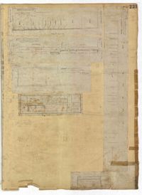
Page 223 of the City Engineer's Plat Book with five plats. Plat 1 shows lots and structures along Poinsett Street, near where it intersects with King Street. Plat 2 shows lots located on Sans Souci Street, near where it intersects with King Street. Plat 3 shows lots located on Line Street, including a lot labelled "City Stables." Plat 4 shows lots along King Street, near where it intersects with Moultrie Street. Plat 5 shows lots and structures located near the intersection of King Street and Romney Street.
Page 227 of the City Engineer's Plat Book with two plats. Plat 1 shows lots and structures located on Grove Street, between King Street and Russell Street. Plat 2 features a "Plot of Ground Surrounding Charleston Colored Industrial School." Plat 2 also shows Fishburne Street, Mount Street, Congress Street, and President Street.
Page 236 of the City Engineer's Plat Book with one plat. The plat features lots located between Romney Street and Cypress Street, and between King Street and a stretch of railroad tracks. Writing in red reads "See Page #242."
Page 230 of the City Engineer's Plat Book with one plat. The Plat features lots located between Chinquapin Street and President Street, and between Bee Street and Spring Street. It also shows several structures, Pine Street, and Chesnut Street. One lot is labelled "Vegetable Garden."
Page 232 of the City Engineer's Plat Book with one plat. The plat shows lots and structures between East Bay Street and the Cooper River, and between Society Street and Vernon Street. The plat also shows Washington Street, Marsh Street, Concord Street, Vernon Street, and Wharf Street.
Page 233 of the City Engineer's Plat Book with one plat. The plat features a stretch of marshland located east of Bay Street. The plat also shows America Street, Cooper Street, Blake Street, several creeks, and land labelled "Magazine."
Page 234 of the City Engineer's Plat Book with one plat. The plat shows lots and structures located on Mill Street, President Street, Lucas Street, and Sixth Street. It also shows a lot labelled "U. S. Arsenal."
Page 231 of the City Engineer's Plat Book with one plat. The plat features lots belonging to "The Cannonsboro Whf & Mill Co." It shows Bee Street, Doughty Street, President Street, Lucas Street, and Mill Street.
Page 166 of the City Engineer's Plat Book with five plats. Plat 1 shows lots and structures located near the intersection of Columbus Street and Meeting Street. Plat 2 features lots located along Moultrie Street, between Meeting Street and Russel Street. Plat 2 also shows King Street and Hampton Street. Plat 3 shows lots located between Meeting Street and a line labeled "South Carolina R. R. Company," near Romney Street, Addison Street, and Poinsett Street. Plat 4 shows a lot located on the north side of Amherst Street. Plat 5 shows lots located near the intersection of Bay Street and Blake Street.
Page 162 of the City Engineer's Plat Book with three plats. Plat 1 shows land located near Payne Street with several streams. Plat 2 shows lots located in the Village of Hampstead, located near America Street. The plat also shows marshland and streams. Plat 3 has numerous tears and holes. Plat 4 shows lots and structures located between Meeting Street and Lynch Street.
Page 169 of the City Engineer's Plat Book with three plats. Plat 1 shows lots and structures on and near Dehon Street, between King Street and Meeting Street. Plat 2 shows lots located between King Street and Meeting Street, south of Romney Street. Plat 3 shows lots and structures located between Chapel Street and Charlotte Street, near where they intersect with Elizabeth Street. One lot is labelled "St. Luke's Church."
Page 165 of the City Engineer's Plat Book with three plats. Plat 1 shows lots located near a "Public Road from and to Charleston." It also shows marsh land, a fishpond, and a garden. Plat 2 shows land located near the intersection of America Street and Brigade Street. Plat 3 shows lots located near the intersection of Meeting Street and Riker Street, including a stretch of land labeled "Low Ground."
Page 164 of the City Engineer's Plat Book with three plats. Plat 1 shows lots located between Meeting Street and Aiken Street, and between Cooper Street and Line Street. Plat 2 shows lots located on Felix Street. Plat 3 shows lots located on Grove Street, and shows a stream and a label reading "Frenchman's Hill."
Page 167 of the City Engineer's Plat Book with two plats. Plat 1 shows lots located between Meeting Street and a line labelled "So. Ca. R. R." Plat 2 shows lots located between Moultrie Street and Line Street, and between America Street and Meeting Street. Plat 2 also shows lots between Hampton Street and Moultrie Street, West of Meeting Street.
Page 163 of the City Engineer's Plat Book with two plats. Plat 1 shows lots and structures located on Friend Street, near its intersections with Queen Street, Broad Street, and an unlabeled street. Plat 2 shows lots located on King Street, near where it intersects with Broad Street.
Page 177 of the City Engineer's Plat Book with two plats. Plat 1 shows lots located between Meeting Street and King Street, near Russell Street, "Rumney" Street, and Poinsett Street. Plat 2 shows lots, structures, and streams located near Hanover Street, America Street, and Payne Street.
Page 92 of the City Engineer's Plat Book with six plats. Plat 1 features a "Plan of the Citadel Square," located between King Street and Meeting Street, and between Calhoun Street and Hudson Street. Plat 1 also shows several buildings, including the Citadel, the "U.S. Gov. Stables," and the "U.S. Hospital." Plat 2 shows lots and several buildings located between Smith Street and Franklin Street. Plat 3 shows lots and structures located along Market Street, between Church Street and Meeting Street. Plat 4 shows lots and structures located near Calhoun Street. Plat 5 shows several lots and structures located on King Street. Plat 6 is affixed to the page so it folds out, and shows lots located near Spring Street, between Chesnut Street and President Street. Plat 6 also shows Pine Street, Cannons Court, and Bee Street.
Page 88 of the City Engineer's Plat Book with eight plats. Plat 1 shows a stream and marshland starting at the Ashley River. Plat 2 features land located near the Ashley River and Grove Street. It also features several structures, some marshland, and a creek. Plat 3 shows land located near Grove Street, including some structures, some marshland, and a stream. Plat 4 shows land located Grove Street, including some buildings, a creek, and marshland. Plat 5 shows lots located between a stretch of marsh and Rutledge Avenue. Plat 5 also shows Congress Street, Legare Street, Huger Street, Moultrie Street, and a race track. Plat 6 features Washington Race Course, located between Grove Street and Moultrie Street, and between Congress Street and an unlabeled Street. Plat 7 shows "34 acres of Marsh" located between the Ashley River and a public cemetery. Plat 8 shows marshland located on the Ashley River, near "new Spring Street" and a creek.
Page 86 of the City Engineer's Plat Book with four plats. Plat 1 shows land starting west of Legare Street and ending east of America Street. Plat 1 also includes Line Street, Pinckney Street, King Street, Meeting Street, America Street, a public square, and several marshes. Plat 2 shows a stretch of land starting west of Legare Street and ending at Drake Street. Plat 2 also shows Line Street, Sheppard Street, Coming Street, St. Phillips Street, King Street, Meeting Street, America Street, a lot labelled "Est of Nells Rope yard," and several marshes. Plat 3 shows 3 plots of land near a road, a marsh, and a pond. Plat 4 shows land near King Street, where it intersects with Huger Street and Charlotte Street.
Page 90 of the City Engineer's Plat Book with four plats. Plat 1 shows lots located between King Street and Russell Street, near Grove Street and Poinsett Street. Plat 2 shows lots located between Meeting Street and King Street, with a strip of land labelled "S.C.R.R.," a common acronym for the South Carolina Rail Road. Plat 3 features lots located near Boigard Street. Plat 4 features land located on the Ashley River, near Grove Street, shows a stream and several structures.
Page 91 of the City Engineer's Plat Book with five plats. Plat 1 shows lots located near Guinard Street. Plat 2 shows lots located between Nassau Street and Meeting Street, and between Johnson Street and Stuart Street. Plat 3 shows lots located along East Bay Street, between Guignard Street and Pinckney Street. Plat 4 features a lot and several structures located near the intersection of Logan Street and Broad Street. Plat 5 features a lot located near the intersection of Broad Street and Rose Lane.
Page 93 of the City Engineer's Plat Book with two plats. Plat 1 features the "U.S. Custom-House Premises," located between East Bay Street and the Cooper River, and Market Street and Gaillard Street. Plat 1 also shows several structures. Plat 2 features a lot near "Smith's Place" and a creek, and shows several structures, including one labelled "Saw and Planning Mill" and another labelled "Engine Boiler room."
Page 103 of the City Engineer's Plat Book with three plats. Plat 1 shows lots located between President Street and Norman Street, near where they intersect with Spring Street. Plat 2 shows lots and some buildings along Bogard Street, between Laurel Street and Percy Street. Plat 3 shows a lot and several buildings located on Percy Street.
Page 98 of the City Engineer's Plat Book with three plats. Plat 1 shows lots between King Street and Meeting Street, including a stretch of railroad track and some marshlands. Plat 2 shows lots located near Rutledge Avenue. Plat 3 shows land located near a public road, showing a creek labelled "into Ashley," and stretches of marshland.
Page 104 of the City Engineer's Plat Book with one plat. The plat shows lots located between Moultrie Street and Cunnington Street. It also shows Lemon Street, Lee Street, Price Street, and Magnolia Street. It also shows a plat labelled "Artilery Society" and another plat labelled "Magnolia Cemetery."
Page 16 of the City Engineer's Plat Book with five plats. Plat 1 shows lots close to the Ashley River located near Tradd Street and Gibbes Street, including a marsh flat labelled as "City Lands." Plat 2 shows lots located near the intersection of Tradd Street and Council Street, including "City marshlands." Plat 3 shows lots located near Gibbes Street and South Bay Street, and includes a dotted line labelled "Low Water Mark." Plat 4 shows land located between Ellery Street and Old Church Street, including a stretch of Raper Street. Plat 5 shows land near the intersection of South Bay Street and "Legare or Johnson Street," and close to the "Low Water" of the Ashley River.
Page 21 of the City Engineer's Plat Book with six plats. Plat 1 shows land between Broad Street and Tradd Street, and Logan Street and New Street, including a sizable portion labelled "Middletons Lots." Plat 2 shows a lot on Broad Street and its buildings. Plat 3 shows lots located near Rutledge Street, Queen Street, Beaufain Street, and Smith Street, and some "City marshlands." Plat 4 shows plots located near Rutledge Street, Beaufain Street, Queen Street, and Smith Street. Plat 5 shows a lot and buildings located near the intersection of Queen Street and Mazyck Street. Plat 6 shows lots of land located on King Street, including one labelled "Unitarian Church."
Page 22 of the City Engineer's Plat Book with five plats. Plat 1 shows lots located near the Charleston Harbor, Concord Street, Pinckney Street, and Pritchard Street. Plat 2 shows lots and structures located near the intersection of Concord Street and Pinckney Street, including a single-story building, a wharf, and a label reading "City property leased." Plat 3 shows a lot on Broad Street labelled "Lot of David McCredie." Plat 4 Shows lots located near Park Street, and between Shepherd Street and Line Street. Plat 5 shows lots near the intersection of Broad Street and Gadsden's Alley labelled with the names of banks.
Page 19 of the City Engineer's Plat Book with six plats. Plat 1 shows lots and buildings located near the intersection of Pitt Street and Bull Street. Plat 2 shows lots and buildings located near the intersection of Meeting Street and Reid Street. Plat 3 shows lots between King Street and Congress Street, also located near Grove Street and Moultrie Street. Plat 4 shows a lot on Amen Street labelled "Thomas N. Gadsen Esq." and noting multiple brick buildings. Plat 5 shows lots located on Cumberland Street. Plat 6 shows lots located on Amen Street and two two-story brick buildings.
Page 17 of the City Engineer's Plat Book with five plats. Plat 1 shows plots of land located on Logan Street. Plat 2 shows land on East Bay Street. Plat 3 shows a plot of land on the corner of East Bay Street and Gibbes Street. Plat 4 shows the "Old Exchange" located at the intersection of East Bay Street and Broad Street. Plat 5 shows lots located on East Bay Street between the intersections with Cumberland Street and Market Street, including a larger lot labelled "New Custom House Lot."
Page 15 of the City Engineer's Plat Book with three plats. Plat 1 features plots located between Rutledge Street and Smith Street, near the intersections with Queen Street. Plat 2 features a lot on the corner of Tradd Street and Savage Street. Plat 3 shows the intersection of Calhoun Street and Rutledge Avenue (also labelled as Rutledge Street) with proposed changes.
Page 30 of the City Engineer's Plat Book with one plat. The plat features the West Point Rice Mill on the Ashley River Channel. It shows numerous buildings and structures, a creek, and the nearby Bull Street, Montague Street, Barre Street, and Gadsden Street.
Page 23 of the City Engineer's Plat Book with one plat. The plat shows lots, buildings, shoals, and mud flats located near the Charleston Harbor on the Cooper River, Concord Street, Pinckney Street, and East Bay Street.
Page 31 of the City Engineer's Plat Book with two plats. Plat 1 shows lots located along a private street, between Mount Street and Congress Street. Plat 2 features lots located between Payne Street and Rutledge Street.
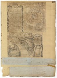
Page 207 of the City Engineer's Plat Book with two plats. Plat 1 is titled "The Plan of Charles Town With its Entrenchments and those made during the Siege by the English 1780," and shows Queen Street, Church Street, Tradd Street, King Street, Broad Street, the State House, the Market, the Arsenal, an "Old Church" and a "New Church." It also shows certain geographic features, including "Cummins Point," Cannons Point, and Hampstead Hill. Plat 2 has a label reading "This Map In every particular copied with a Pen from an Old Plat of Charles Town dated 1671 found in a Book of Plats of various parts of U.S.A. printed in London 1671." Plat 2 shows several geographic features such as rivers and islands, and features numerous illustrations. The largest illustration depicts two groups of people interacting from either side of a stream. Each group holds a single spear.
Page 205 of the City Engineer's Plat Book with two plats. Plat 1 shows "Lots in the Village of Rikersville," and shows Mechanics Street, 21 acres of marsh, a building labelled "Car Factory," a building labelled "Machinery," a building labelled "Wheat Mill," a canal, and a pond. Plat 2 shows lots and structures located between Pinckney Street and Market Street. Plat 2 also shows Hayne Street, Guignard Street, Church Street, Anson Street, Rafer's Alley, East Bay Street, a building labelled "Cotton Press," a park, and a building labelled "The Market."
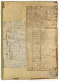
Page 211 of the City Engineer's Plat Book with two plats. Plat 1 features "Pregnal's Ship Yard," located near Concord Street, Laurens Street, Vernon Street, and Wharf Street. Plat 1 also shows structures with labels such as "Rough Rice Storehouse," "Mill," "Coal Yard Office," and "Stable." Plat 2 shows numerous streets including Meeting Street, King Street, Boundary Street, Columbus Street, and Bay Street.
Page 210 of the City Engineer's Plat Book with two plats. Plat 1 features land set aside for a park, located between Lynch Street and Rutledge Street, and between Bennett Street and Calhoun Street. Plat 2 shows lots located between Simons Street and Gordon Street, near where they intersect with Rutledge Avenue.
Page 218 of the City Engineer's Plat Book with two plats. Plat 1 features a proposed extension to Boigard Street, located between Ashley Street and Rutledge Avenue. Plat 1 also shows Payne Street, Line Street, and a lot labeled "Thompson's Garden." Plat 2 shows lots and structures located between St. Philips Street and King Street, and between Radcliffe Street and Warren Street.
Page 219 of the City Engineer's Plat Book with one plat. The plat features proposed streets on "Part of the West Point Mill Property," including an extension of Calhoun Street. The plat also shows a dam, a storehouse, and a creek.
Page 216 of the City Engineer's Plat Book with one plat. Plat 1 shows lots and structures located east of the Ashley River, near Gadsden Street, Beaufain Street, and Wentworth Street.
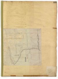
Page 217 of the City Engineer's Plat Book with one plat. The plat features city lands known as Potters Field. It also shows streams, marshland, President Street, Mount Street, Fishburne Street, Line Street, and Congress Street.
Page 214 of the City Engineer's Plat Book with two plats. Plat 1 shows lots located between Savage Street and Chisolm Street, and between Broad Street and Tradd Street. Plat 1 also shows Rutledge Avenue. Plat 2 shows a similar area to Plat 1, but also includes New Street, Franklin Street, Trapman Street, and Lynch Street.
Page 134 of the City Engineer's Plat Book with eleven plats. Plat 1 shows lots and structures located on Lynch Street. Plat 2 shows a lot located on Wentworth Street, with a building labelled "Charleston Engine House." Plat 3 shows lots located near the intersection of Calhoun Street and Ogier Street. Plat 4 shows lots located on Ogier Street. Plat 5 shows lots located on Ogier Street, near its intersection with Calhoun Street. Plat 6 shows lots located along Clifford Alley, near where it intersects with Archdale Street. Plat 7 shows lots located near the intersection of Calhoun Street and Ogier Street. Plat 8 shows lots located near the intersection of Vanderhorst Street and Ogier Street. Plat 9 shows lots located near the intersection of Calhoun Street and Ogier Street. Plat 10 shows lots located on and near Boundary Street, near where it intersects with St. Philips Street. Plat 11 features a lot owned by "The Unitarian Church," located on the intersection of Archdale Street and Clifford Alley.
Page 140 of the City Engineer's Plat Book with six plats. Plat 1 shows lots and structures located on and near Queen Street, between King Street and Meeting Street. Plat 2 shows lots located on Rutledge Street. Plat 3 shows lots located between George Street and Burns Lane, near where they intersect with Meeting Street. One lot is labelled "Property of Charleston High School." Plat 4 shows lots and structures located between Lynch Street and the Ashley River, near Broad Street and Beaufain Street. Plat 5 shows lots and structures located on the corner of King Street and Society Street. Plat 6 shows the same area as Plat 5, but with some changes to the structures.
Page 136 of the City Engineer's Plat Book with seven plats. Plat 1 shows lots and structures located on and near the intersection of Liberty Street and St. Philips Street. Plat 2 shows lots located on Archdale Street, near Bennett's Mill Pond. Plat 3 shows lots and structures located on and near the intersection of Rutledge Street and Montague Street. Plat 4 shows lots and structures located on Archdale Street, including a building labelled "Hope Engine House." Plat 5 shows a lot located along Clifford Alley, near a lot labelled "Unitarian Church." Plat 6 shows lots located along King Street. Plat 7 shows lots located on and near Calhoun Street, located between Smith Street and Rutledge Street.
Page 139 of the City Engineer's Plat Book with five plats. Plat 1 shows a lot and structures located at the corner of Calhoun Street and Alexander Street. Plat 2 shows lots located on Queen Street, near where it intersects with Back Street. Plat 3 shows lots located on and near Mazyck Street, near its intersection with Magazine Street. Plat 3 also shows lots labelled "Roper Hospital Lot," and "City Lot." Plat 4 shows lots located between Vanderhorst Street and Boundary Street, and between Coming Street and Pitt Street.
Page 142 of the City Engineer's Plat Book with four plats. Plat 1 shows lots and structures located on the corner of Meeting Street and Burns Lane, with one lot labeled "Property of Charleston High School." Plat 2 shows lots located on Pitt Street. Plat 3 shows lots and structures located on Pitt Street. Plat 4 shows land located between Broad Street and Wentworth Street, and between Lynch Street and the Ashley River. Plat 4 also shows a line labelled "Low Water Mark of Ashley River," Comings Creek, and a "City Mud Flat, lying North of Creek."
Page 135 of the City Engineer's Plat Book with seven plats. Plat 1 shows lots on a city block located between Bennett Street and Calhoun Street, and between Rutledge Street and Lynch Street. Plat 2 shows a lot labelled "Cannon's Mall," located on the intersection of Calhoun Street and Rutledge Street. Plat 3 shows lots located on Meeting Street. Plat 4 shows the same lot as Plat 2. Plat 5 shows a lot located on King Street. Plat 6 shows lots and structures located on King Street, including a graveyard, a Meeting House, and a kitchen.
Page 147 of the City Engineer's Plat Book with three plats. Plat 1 shows lots located between King Street and land owned by the South Carolina Railroad Company. Plat 2 shows lots and structures located between Charlotte Street and Calhoun Street, and between Washington Street and Meeting Street. It also shows Alexander Street, Elizabeth Street, and Henrietta Street. Plat 3 shows lots and structures located on and near the intersection of President Street and Cannon's Court.
Page 146 of the City Engineer's Plat Book with three plats. Plat 1 shows lands located on and near the intersection of East Bay Street and Hasell Street. Plat 2 features a lot located on the north side of John Street, between Meeting Street and King Street. It also shows a lot labelled "So. Ca. RR. Co." Plat 4 shows a park and buildings located between King Street and Meeting Street, and between Calhoun Street and Hutson Street.
Page 143 of the City Engineer's Plat Book with two plats. Plat 1 shows land located near the intersection of Washington Street and Chapel Street, with two wharfs and the "site of the creek in 1801." Plat 2 shows lots and structures located on the west side of Washington Street.
Page 52 of the City Engineer's Plat Book with seven plats. Plat 1 features a lot located on Queen Street. Plat 2 shows land between New Street and the Ashley River Channel, including stretches of Tradd Street, Broad Street, New Street, Savage Street, Rutledge Street, and Lynch Street. Plat 2 also shows some marshlands in the area. Plat 3 shows lots located along Greenhill Street, near the intersection with Tradd Street. Plat 4 shows an area similar to Plat 2, with certain buildings and marshlands labelled. Plat 5 shows a lot located on the intersection of Tradd Street and New Street, featuring several buildings and other structures. Plat 6 shows land located near Tradd Street, with marshes and shoals labelled. Plat 7 features lots between Tradd Street and Gibbes street, and has a label reading "City marshland." Plat 7 also shows New Street, Savage Street, and Council Street.
Page 51 of the City Engineer's Plat Book with seven plats. Plat 1 shows land located between Tradd Street and the Ashley River, and labels several features of geography such as a patch of marsh and some land labelled "Hard at low water." Plat 1 also shows a lot labelled "City Lands." Plat 2 shows lots and buildings located near the intersection of Tradd Street and Savage Street. Plat 3 shows land located on the west side of New Street. Plat 4 features a lot located at the intersection of New Street and Tradd Street. Plat 5 features lots located near the intersection of New Street and Tradd Street. Plat 6 shows lots located on and near Tradd Street. Plat 7 shows structures located near the intersection of New Street and Broad Street, including a building labelled "Theatre."
Page 54 of the City Engineer's Plat Book with six plats. Plat 1 shows lots located near the intersection of Broad Street and Friend Street. Plat 2 shows land between the Ashley River's low water mark and Smith Street, and between Beaufain Street and Broad Street. It also labels Comings Creek, and an "Edge of High Land." Other Streets on Plat 2 include "Barre Street," Gadsden Street, Beaufain Street, Lynch Street, Queen Street, and Rutledge Street. Plat 3 shows numerous city blocks, "School Land," and a large creek near the Ashley River. Other streets on Plat 3 include Beaufain Street, Wentworth Street, Montague Street, Bull Street, and Pitt Street. Plat 4 shows a similar stretch of land to Plat 3. Plat 5 shows features a lot on Beaufain Street. Plat 6 shows a lot and buildings located near the intersection of King Street and Hutson Street.
Page 58 of the City Engineer's Plat Book with six plats. Plat 1 shows lots between Broad Street and Short Street, near their intersections with Mazyck Street. Plat 2 features lots on Greenhill Street, Limehouse Street, and Tradd Street. Plat 2 also shows a line labelled "Edge of High Land." Plat 3 shows lots near Broad Street, including lots labelled "Hawens Square" and "Burying Ground." Plat 3 also shows structures labelled "Magazine" and "Work House." Plat 4 shows lots located on King Street. Plat 5 shows land located between Meeting Street and Lee Street, and a dotted line labelled "City Boundary." Plat 6 shows lots located between President Street and Norman Street.
Page 57 of the City Engineer's Plat Book with seven plats. Plat 1 shows buildings, wharves, and docks located near South Bay Street. Plat 2 shows lots located near the intersection of Church Street and Chalmer Street, including buildings labelled "Stable," "Kitchen," and "Carolina Hotel." Plat 3 features a lot and several buildings located near Broad Street. Plat 4 features a lot and buildings located on Broad Street. Plat 5 shows lots located near the intersection of Broad Street and Rutledge Street. Plat 6 shows lots located between Broad Street and "St. Michaels Alley." The last plat shows lots on East Bay Street, between Pinckney Street and Hasell Street.
Page 56 of the City Engineer's Plat Book with seven plats. Plat 1 shows lots between Savage Street and Tradd Street. Plat 2 shows lots and some buildings on South Bay Street. Plat 3 shows lots between Savage Street and Broad Street. Plat 4 shows a lot and several buildings at the intersection of Friend and Queen Street. Plat 5 shows land near the corner of Legare Street and Gibbes Street, and a few buildings. Plat 6 shows a lot on the west side of Friend Street. Plat 7 shows lots located between Broad Street and Tradd Street, and between Lynch Street and the Ashley River.
Page 61 of the City Engineer's Plat Book with four plats. Plat 1 features a lot and buildings located between East Bay Street and Concord Street, and between Pritchard Street and Hasell Street. Plat 2 shows lots between Pritchard Street and Hard Alley, near their intersections with East Bay Street. Plat 3 shows lots located on Pritchard Street, between East Bay Street and Concord Street, with some buildings labelled. Plat 4 shows lots located near the intersection of Meeting Street and Queen Street with some buildings and structures labelled.
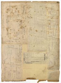
Page 67 of the City Engineer's Plat Book with two plats. Plat 1 features three lots located on Meeting Street, with stores and yards labelled. Plat 2 shows a stretch of land near the Ashley River, and the intersection of Calhoun and Lucas Street. Plat 2 also shows a large building labelled "West Point Rice Mill" and a stretch labelled "Mill Pond."
Page 59 of the City Engineer's Plat Book with two plats. Plat 1 shows lots on East Bay Street, between Pritchard Street and Rose Lane. Plat 2 shows a lot and buildings belonging to the Charleston Gas Light Company, located on Church Street.
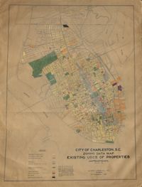
Hand-colored, linen map showing Charleston peninsula existing lot uses from Murray Boulevard to the northern limits of the city at Mount Pleasant Road. Map shows one, two, and multiple dwelling units, service stations, garages, industrial sites, and railroads. Information on map was compiled during field observations made from October through December 1930. Map measures 46.25" by 63."
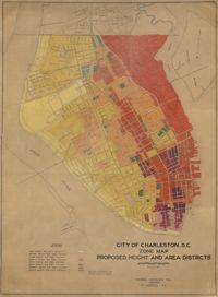
Hand-colored, linen map showing proposed height and area districts for the city of Charleston. Map shows eight height and area districts from Murray Boulevard to the northern limits of the city at Mount Pleasant Road. Map measures 42" by 60".
Linen map showing distribution of schools in Charleston from Murray Boulevard to the northern limits of the city at Mount Pleasant Road. Map shows school district lines, developed and undeveloped school properties and racial population disbursement indicated by white circles for white residents and black circles for black residents. Map is found on page 11 of the Report of the City Planning and Zoning Commission. Map measures 41.25" by 59".
Linen map showing existing and proposed parks; thoroughfares; schools; residential, business, and industrial districts; and suggested streets from Murray Boulevard to the northern limits of the city at Mount Pleasant Road. Residential districts are identified by racial makeup and labeled as white residence and colored residence districts. Map is found on page 11 of the Report of the City Planning and Zoning Commission. Map measure 41" by 59".
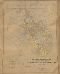
Hand-colored, linen map showing Charleston peninsula existing lot area per dwelling from Murray Boulevard to the northern limits of the city at Mount Pleasant Road. The maps shows lots less than 1,000 square feet; lots more than 1,000 square feet and less than 1,500 square feet; lots more than 1,500 square feet and less than 2,500 square feet; lots more than 2,500 square feet and less than 3,000 square feet; lots more than 3,000 square feet and less than 4,500 square feet; and lots greater than 4,500 square feet. Map measure 47" by 63".
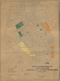
Hand-colored, linen map showing existing city properties including parks, playgrounds, port utilities, public buildings, fire stations, municipal service properties, and miscellaneous properties from Murray Boulevard to the northern limits of the city at Mount Pleasant Road. Map measures 42" by 60".
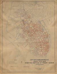
Hand-colored, linen map showing Charleston peninsula existing depths of front yards (5 feet and under, 6 to 14 feet, 15 to 24 feet, 25 feet and over). Map reflects Murray Boulevard to the northern limits of the city at Mount Pleasant Road. Map measures 47" by 63".
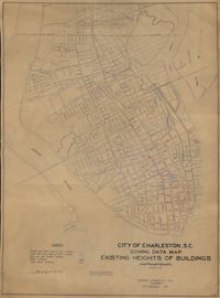
Hand-colored, linen map showing Charleston peninsula heights of buildings from Murray Boulevard to the northern limits of the city at Mount Pleasant Road. Height in stories is indicated by color coding. Map shows buildings of three stories or more. Map measures 42" by 60".
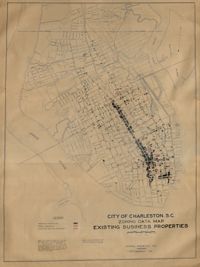
Hand-colored, linen map showing Charleston peninsula existing business properties, public garages, and gasoline service stations from Murray Boulevard to the northern limits of the city at Mount Pleasant Road. Map measures 46.75" by 63".
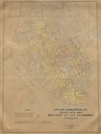
Hand-colored, linen map showing Charleston peninsula lot occupancy from Murray Boulevard to the northern limits of the city at Mount Pleasant Road. Map is color coded to show lot occupancy percentages on the peninsula. Map measures 46.5" x 63".