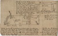
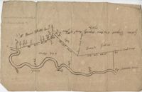
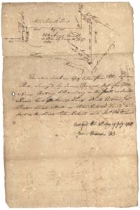
600 acres plot granted to Richard Floyd residing in Colleton County lying and budding on the southside of Bohickett Creek, shows surrounding property names and creeks, shows land notes but no land type or details. Also shown is 200 acres granted by the Lords Proprietors by William Arnell in Colleton County. Names associated with this plat are Richard Floyd, Graeme [?], the Lords Proprietors, Michael Ranell, Thomas Broughton, Robert Gibbes, William Atnel, Timothy Bellemey, Anthony Matthews, Ambross Hill, John Prescot and Neufville. Notable geographic locations include John's Island, Bohickett Creek, Colleton County, Ambrose Hill, Stono River, and Keywa [Kiawah] Island.
Copy of a plat of land in St. Andrew’s Parish, 103 acres are marsh land. Little other detail or explanation. At the time of the copy belonged to George Wagner. Names associated with this plat include Stephen Bull, Thomas Jones, George Wagner, Richard Godfrey, Nathaniel Brown and Thomas Jones.
Plat of 500 acres in Colleton County. Very little detail included. Names associated with this plat are Alexander French, Thomas Clifford, Bettison, Francis Young, George Hunter, and John Bartys.
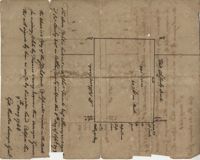
FRONT: Plat is on the northside of the Ashley River. Contains 200 acres. BACK: Plat contains 36 acres on the North side of the Ashley River. Names associated with this plat are Richard Baker, Elibee Baker, John Baker, Josiah Baker, John Guptan, James Cantley [?], James Glen, John Stevens, Joseph Child, John Ainslee, Richard Baker, William Cattell and George Hunter. Notable geographic locations include St. George's Parish, Ashley River and Berkeley County.
Plat includes 624 acres surveyed for Gideon DuPont. Plat does not contain structures. Names associated with this plat are Gideon DuPont, William Thomas Elliot, Captain Daniel Godin, and Middleton. Notable geographic locations are St. Bartholomew's Parish, the Ashepoo River and Deer Creek.
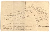
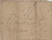
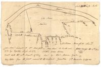
26 acres of land exchanged by John Stanyarn with Col. John Gibbes in the north side of Marshall's Creek on John's Island. Bounding on the south on lands belonging to the said Stanyarn and on all other sides on lands of John Gibbes. Laid out in 1753. Names associated with this plat are John Stanyarn, John Gibbes and Wilkins. Notable geographic locations include Johns Island and Marshall's Creek.
Plat of 163 acres in the St. George District. Very little detail or explanation provided on the plat. Names associated with this plat are David Run, John Woodrich, Elibu [?] Baker, John Drayton, and B. Wood [?]. Notable geographic locations include St. George Parish and St. George District.
Plat of 300 acres in Berkeley County. Very little detail included in the plat. Names associated with this plat are James McKelvey, John Evans and Sarah Vance. Notable geographic locations include Berkeley County and Russells Creek.
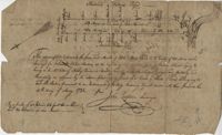
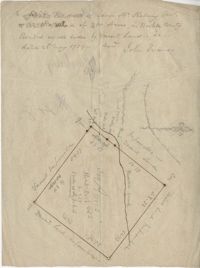
250 acre plot given to Peter Lesesne on the 20th of February 1760, butting and bounding on the south side of the Santee River. Names associated with this plat are Peter Lesesne, James Thomson, Peter Robert, Joseph Manap [?], and Phippes.
Plat of 300 acres in St. Andrew’s Parish on the Stono River originally granted to William Branford. At the time of the copy it belonged to George Wagner. Names associated with this plat are William Branford, George Wagner, Egerton Leigh, Thomas Boone and Elizabeth Hutchins.
Limit your search
John McCrady Plats and Deeds Collection✖[remove]246