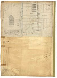
Page 157 of the City Engineer's Plat Book with two plats. Plat 1 features a lot of land located on the South Side of Line Street. Plat 2 shows lots located on and near the intersection of Spring Street and Kracke's Court.
Page 194 of the City Engineer's Plat Book with three plats. Plat 1 shows lots located near the intersection of Line Street and Comming Street. Plat 2 shows lots and structures located near Chesnut Street. Plat 3 shows lots and structures located on and near Calhoun Street, between Meeting Street and Anson Street.
Page 109 of the City Engineer's Plat Book with six plats. Plat 1 shows lots located near the intersection of Exchange Street and Champney Street. Plat 2 shows lots and some buildings located on Church Street. Plat 3 shows lots located along Elliott Street, between East Bay and Church Street. Plat 4 shows lots and structures located near the corner of Church Street and Atlantic Street. Plat 5 shows lots and structures located near the corner of Church Street and Atlantic Street. Plat 6 shows lots and structures located near the intersection of East Bay Street and Guignard Street.
Page 204 of the City Engineer's Plat Book with one plat. The plat shows lots and structures located near the intersection of Meeting Street and Broad Street.
Page 138 of the City Engineer's Plat Book with three plats. Plat 1 features a lot located on Hasell Street, with a large building labelled "St. Mary's Church." Plat 2 shows lots and structures located between Rutledge Street and Trapmann Street, and between Queen Street and Broad Street. Plat 3 features a lot located on Radcliffe Street, between Rutledge Street and Smith Street.
Page 169 of the City Engineer's Plat Book with three plats. Plat 1 shows lots and structures on and near Dehon Street, between King Street and Meeting Street. Plat 2 shows lots located between King Street and Meeting Street, south of Romney Street. Plat 3 shows lots and structures located between Chapel Street and Charlotte Street, near where they intersect with Elizabeth Street. One lot is labelled "St. Luke's Church."
Page 177 of the City Engineer's Plat Book with two plats. Plat 1 shows lots located between Meeting Street and King Street, near Russell Street, "Rumney" Street, and Poinsett Street. Plat 2 shows lots, structures, and streams located near Hanover Street, America Street, and Payne Street.
Page 136 of the City Engineer's Plat Book with seven plats. Plat 1 shows lots and structures located on and near the intersection of Liberty Street and St. Philips Street. Plat 2 shows lots located on Archdale Street, near Bennett's Mill Pond. Plat 3 shows lots and structures located on and near the intersection of Rutledge Street and Montague Street. Plat 4 shows lots and structures located on Archdale Street, including a building labelled "Hope Engine House." Plat 5 shows a lot located along Clifford Alley, near a lot labelled "Unitarian Church." Plat 6 shows lots located along King Street. Plat 7 shows lots located on and near Calhoun Street, located between Smith Street and Rutledge Street.
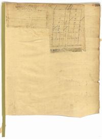
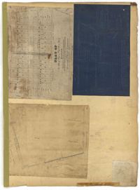
Plan of approximately 1500 acres on Black River near Georgetown part now belonging to Kinloch and Gadsden. Names associated with this plat are Gadsden, Kinloch, Alston, Thomas Gadsden, James Lloyd, and Morreau [?] Sarrazin.
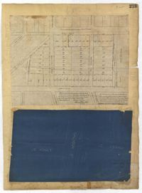
Page 213 of the City Engineer's Plat Book with two plats. Plat 1 features lots located between Savage Street and Chisolm Street, and between Tradd Street and Broad Street. Plat 1 also shows New Street, Rutledge Avenue, Lynch Street, Trapmann Street, and a lot labelled "Chisolm Mill Property." Plat 2 shows Calhoun Street's intersections with Lynch Street and Ashley Street.
Page 228 of the City Engineer's Plat Book with two plats. Plat 1 shows the ground elevation near Mount Pleasant Street, between the Ashley River Marsh and the Cooper River Marsh. It also shows where Mount Pleasant Street intersects with Meeting Street and King Street. Plat 2 shows lots and structures located on and near Magazine Street, between Franklin Street and Smith Street.
Page 117 of the City Engineer's Plat Book with two plats. Plat 1 shows lots located near the Cooper River. Plat 2 shows marshlands, bodies of water, and lots located near the Ashley River.
Page 180 of the City Engineer's Plat Book with one plat. The plat shows lots located on and near Brigade Street, Lee Street, the City Boundary, and the "N.E.R.R. Right of Way."
Page 144 of the City Engineer's Plat Book with five plats. Plat 1 shows lots on and near the Cooper River channel, near Boundary Street, Charlotte Street, Washington Street, and Alexander Street. Plat 1 also shows a creek and a stretch of marshland. Plat 2 shows lots located near the intersection of South Street and America Street. Plat 3 features structures located on the intersection of South Street and America Street. Plat 4 shows lots and structures located at the intersection of President Street and Cannon's Court. Plat 5 shows lots located between Drake Street, America Street, and Alexander Street.
Page 114 of the City Engineer's Plat Book with elven plats. Plat 1 features lots located at the corner of King Street and Queen Street. Plat 2 shows a strip of land on the west side of King Street. Plat 3 shows lots along King Street. Plat 4 shows lots located near the intersection of Savage Street and Tradd Street. Plat 5 shows lots located on King Street. Plat 6 shows lots located near the intersection of King Street and Queen Street. Plat 7 shows lots located on King Street. Plat 8 shows a lot located on King Street. Plat 9 shows lots located near the intersection of South Bay Street and Legare Street. Plat 10 shows a lot on King Street. Plat 11 shows lots located near the intersection of Council Street and Gibbes Street.
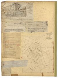
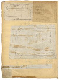
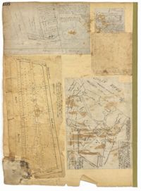
Page 123 of the City Engineer's Plat Book with six plats. Plat 1 shows lots and structures located on and near Calhoun Street, between Anson Street and Meeting Street. Plat 2 shows lots and structures located between East Bay Street and Cooper River. Plat 3 shows lots and buildings located near Meeting Street. Plat 4 shows lots near a road, and has a large hole in the middle. Plat 5 shows lots and buildings located on Beaufain Street. Plat 5 shows lots located near an intersection, and has several holes in the paper.
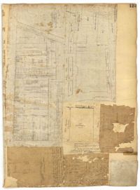
Page 122 of the City Engineer's Plat Book with three plats. Plat 1 shows lots and structures on Meeting Street. Plat 2 shows lots and structures located near the intersection of Anson Street and Laurens Street. Plat 3 shows lots located between Moultrie Street and Huger Street, near Rutledge Avenue.
Page 108 of the City Engineer's Plat Book with five plats. Plat 1 features lots and some structures located near South Bay Street's intersections with Meeting Street and Church Street. It also shows a lot labelled "Battery Garden." Plat 2 shows lots located near East Bay Street. Plat 3 features White Point Garden, also known as Battery Park, located south of South Battery Street, near the Church Street and Meeting Street. Plat 4 shows a lot located near the intersection of Meeting Street and Broad Street. Plat 5 shows land located between Broad Road and the Ashley River, and includes labels marking salt marshes, cleared lands, a fish pond.
Page 137 of the City Engineer's Plat Book with six plats. Plat 1 shows lots located on and near Mazyck Street, between Short Street and King Street. Plat 2 shows lots located on and near the intersection of Pitt Street and Montague Street. Plat 3 features a lot located on the intersection of Archdale Street and Berresford Street. Plat 4 features a lot located at the intersection of Queen Street and Meeting Street. Plat 5 shows a lot located at the intersection of Queen Street and King Street. Plat 6 shows lots located on and near the intersection of Mazyck Street and Magazine Street, including one labelled "Roper Hospital Lot."
Page 65 of the City Engineer's Plat Book with six plats. Plat 1 shows wharves and other structures located near the intersection of East Bay Street and Elliott Street, and also shows a building labelled "Old Post Office." Plat 2 features a wharf on the Cooper River, and shows several structures. Plat 3 shows wharves and brick storehouses located near the intersection of Prioleau Street and Queen Street. Plat 4 shows lots near the intersection of Bull Street and Smith Street. Plat 5 shows lots and structures located near the intersection of King Street and Morris Street. Plat 6 shows land located along a stretch of Coming Street, between Race Street and Sumter Street.