Plat of 300 acres in Berkeley County. Very little detail included in the plat. Names associated with this plat are James McKelvey, John Evans and Sarah Vance. Notable geographic locations include Berkeley County and Russells Creek.
250 acre plot given to Peter Lesesne on the 20th of February 1760, butting and bounding on the south side of the Santee River. Names associated with this plat are Peter Lesesne, James Thomson, Peter Robert, Joseph Manap [?], and Phippes.
Plat of 300 acres in St. Andrew’s Parish on the Stono River originally granted to William Branford. At the time of the copy it belonged to George Wagner. Names associated with this plat are William Branford, George Wagner, Egerton Leigh, Thomas Boone and Elizabeth Hutchins.
1000 acres of land laid out for Peter Sinclair in St. James Parish, Santee. Names associated with this plat are Peter Sinclair, Susannah Lowndes, Peter Morison, Dupree, Richard Wither and Lewis Morison.
Plat of 1000 acres is surrounded by vacant land. Names associated with this plat are John Stuart. Notable geographic locations include Berkeley County and St. Stephen's Parish.
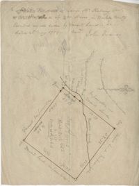
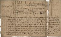
True copy of Peter Sinkler plat contains 310 acres in Craven County [now in parts of Berkeley, Charleston, Georgetown, and Williamsburg counties] bounding northwest on land of Isaac Porcher and Rene Pyre, southeast on land of Robert Taylor and Rene Ravenel, and northwest on Santee River. Names associated with this plat are Peter Sinkler, Robert Taylor, Ephraim Mitchell, Rene Pyre, Isaac Porcher, Rene Ravenel, John Brernon, and Henry Mowlon. Notable geographic locations include St. James Parish, the Santee River and Craven County.
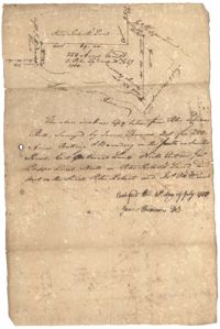
Plan of a tract of 1000 acres of land in Wall Eye Swamp in Craven County [now in parts of Berkeley, Charleston, Georgetown, and Williamsburg counties]. Names associated with this plat are Samuel Cooper, James Sinkler, Peter Sinkler, Isham Moore, John Bremar, and William Bull.
Plat of 4883 acres belonging to Thomas Smith. Very little detail, only the outline of the property is included. Names associated with this plat are Thomas Smith, General Oglethorpe, Smith, Thomas Elliott, Hugh Bryan, and Allen. Notable geographic locations include Granville.
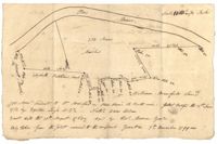
Plat of 500 acres granted to Robert Cahousac January 10,1771. Names associated with this plat are Robert Cahousac, Samuel Cooper, Gabriel Gigneliat [?], Mitchum, Witten, Zachariah Villeponteux, William Mazyck, Juxbury Lumber Co, William Washington, and Charles Parker. Notable geographic locations include St. Bartholomew's Parish and Charleston County.
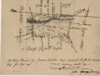
400 acres of land once owned by James Wrixon, then Purchas Morgan, and then Henry Webster who conveyed the land to Ezekiel Branford and Christopher Peters. 250 acres came to the ownership of Ezekiel Branford (N1 and N2) and the remaining 150 acres owned by Christopher Peters (N3). The dates of purchase can be found on the plat. The lands contain pine, gum, cypress, white oak and hickory trees. The lands lie to the east of the Ponpon River. Names associated with this plat include Henry Webster, James Wrixon, Ezekiel Branford, Christopher Peters, Purchas Morgan and Alexander Watkin.