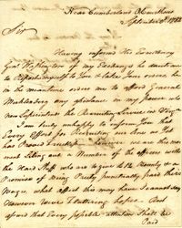
Letter from William Moultrie to Benjamin Lincoln informing him of his moving his troops (400 Continental troops, artillery, 4 pieces of field artillery, and 350 militia) to join Lincoln.
Letter from Charles Scott to Nathanael Greene informing him of his orders from General Washington to aid General Muhlenberg in recruitment efforts in Virginia before reporting to General Greene.
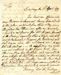
Letter from John Habersham to Benjamin Lincoln regarding the exchange of prisoners and the receipt of American prisoners that were being held in Savannah.
Caption in German: 'Belagerung von Charleston.--Gen. Gillmore's hauptquartier auf Morris Island.' [Siege of Charleston.--Gen. Gillmore's headquarters on Morris Island.]
Caption: 'The siege of Charleston--View from the sea-face of Fort Wagner.--sketched by Mr. Theodore R. Davis.--[See Page 621.]' [full date September 26, 1863.]
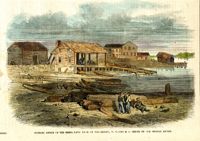
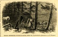
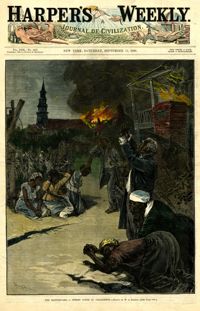
[Color image.] Caption: 'Feeding 8,000 people with rations of rice and salt at West Point Mills, on the Ashley River, Charleston S.C.-- From a sketch by our Special Artist, W.T. Crane.' [full date April 15, 1865.]
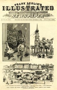
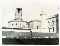
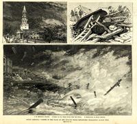
Main caption: 'South Carolina.--scenes in the track of the cyclone which devastated Charleston, August 25th. See page 43. 1. St. Michael's Church [upper left]. 2. Scene on the water front after the storm [top right]. 3. Destruction on South Battery [bottom].' [full date September 5, 1885.]
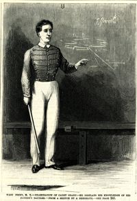
Caption: 'West Point, N.Y.--examination of Cadet Grant--he displays his knowledge of his father's battles.--from a sketch by A. Berghaus.--see page 241.' [full date June 24, 1871.]
List of volunteer firefighters of city engine number 6, including their names, ages, description, occupation, and residence. Donated to the Charleston Museum by Charles Pequette, 1925
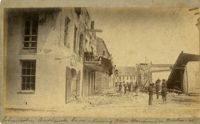
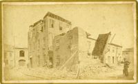
Caption: 'Cook's Earthquake Views of Charleston and Vicinity. Taken after the 31st of August, 1886. No.21, Broad Street, south side.' Sign on building, at right, reads: 'Cigars & Tobacco' and 'W.W. Smith, 27.' Charleston city directory for 1886 lists William M. Smith, seal, stencil and stamp works, at 29 Broad Street.
Caption: 'Cook's Earthquake Views of Charleston and Vicinity. Taken after the 31st of August, 1886. No.25, Vendue Range.' Written on front, at bottom: 'Charleston Earthquake scene - Vendue Range, foot of Queen St. near the wharf.' Sign for John Werner visible. Charleston city directory for 1886 shows business at 27 Vendue Range.
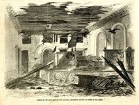
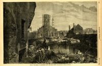
Caption: 'Quarters of the Union officers exposed to the Federal fire in Charleston.--sketched by one of the Officers.--[see page 550.]' [full date August 27, 1864.]
Caption: 'Cook's Earthquake Views of Charleston and Vicinity. Taken after the 31st of August, 1886. No.62, Wm. [William] Ravenel, East Battery, front.' Written on front, at bottom: 'Earthquake scene, Charleston, So.Ca. - Ravenel House'
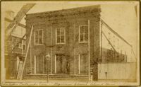
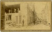
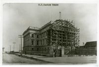
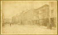
Charleston Earthquake scene. Written on front, at bottom: 'Broad St.' Image shows The News and Courier. Charleston city directory for 1886 lists it at 19 Broad Street.
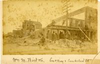
Charleston Earthquake scene. Written on front, at bottom: 'Wm M. Bird & Co. East Bay & Cumberland St.' Sign on building reads: '205, Wm. M. Bird & Co' and '203, Wm E. Holmes.'
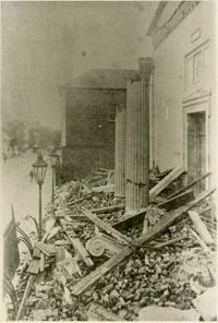
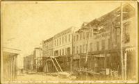
Caption: 'Cook's Earthquake Views of Charleston and Vicinity. Taken after the 31st of August, 1886. No.27, Hayne Street - ruins of three large buildings.' Sign on column at left reads: 'Charleston Bag Factory.' Charleston city directory for 1886 shows a bag factory at 15-19 Hayne Street.
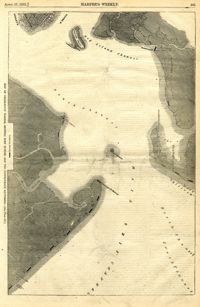
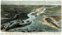
[Color image.] Caption (in French): 'Evenements des Etats-Unis: Charleston et ses fortifications. [Events of the United States: Charleston and its fortifications.] 1--Charleston. 2--Riviere Ashley [Ashley River]. 3--Chemin de fer de Savannah [Savannah Railway]. 4--Riviere Cooper [Cooper River]. 5--Riviere Wando [Wando River]. 6--Fort Pinkney [Castle Pinckney]. 7--Fort Ripley. 8--Fort Johnson (ile James) [James Island]. 9--Riviere Stone [Stono River]. 10--Fort Sumter. 11--Fort Moultrie. 12--Batterie Gregg (pointe de Gumming) [Battery Gregg (Cummings Point)]. 13--Fort Wagner. 14--Batteries rasantes du general Gilmore [grazed batteries of General Gilmore]. 15--Ouvrages pris par les federaux. [Works undertaken by the Federals]. 16--Phare Inlet [Lighthouse inlet]. 17--Batteries federales (ile Folly) [Federal Batteries (Folly Island)]. 18--Canonnieres et vaisseaux cuirasses [gunboats and ironclads]. 19--Hotel. 20--Ile et batteries Sullivan [Sullivan Island and Batteries]. 21--Moultrie. 22--Mont Pleasant [Mount Pleasant]. 23--Breach Inlet. 24--Shem Creek. 25--Batteries construite par les confederes sur l'ile James, dans le voisinage du fort Johnson [Batteries built by the Confederates on James Island, in the vicinity of Fort Johnson].
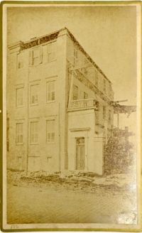
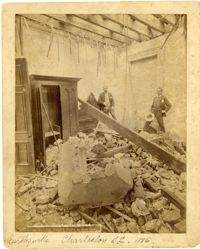
Charleston Earthquake scene. Possibly a copy of No.11 of Cook's Earthquake Views. Shows damage to the Charleston Hotel, demolished in 1960, which stood at 200 Meeting Street. 'Charleston Hotel, Hayne & Pinckney' is typewritten onto the image. Hayne and Pinckney Streets were two of the boundary streets that surrounded the hotel.
Charleston Earthquake scene. Sign at bottom of image: 'Mr. August Melm's room, 21 King Street.' Also, written on front, at bottom: 'Earthquake - Charleston S.C. 1886.' Charleston city directory for 1886 lists August Melm, a local attorney, as boarding at 21 King Street.
Caption: 'The Siege of Charleston--evacuation of Morris Island by the Rebels on the night of September 6, 1863.--sketched by Mr. Theodore R. Davis. [see page 621.]' [full date September 26, 1863.]
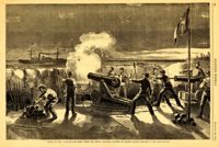
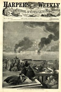
Caption: 'The Siege of Charleston--the attempt to blow up the ironsides, Capt. Rowan, with a torpedo, Oct. 5.--from a sketch by our Special Artist.' [full date October 31, 1863.]
List of volunteer firefighters of city engine number 9, including their names, ages, description, occupation, and residence. Donated to the Charleston Museum by Charles Pequette, 1925
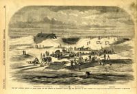
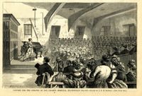
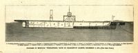
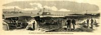
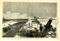
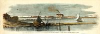
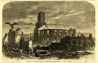
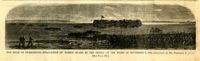
Caption: 'The new batteries erected on Morris Island for the defence of Charleston Harbor and the reduction of Fort Sumpter (sic).--from a sketch by our Special Artist in Charleston, S.C.--see page 295.' Identified with additional captions are: 1.The Iron-clad Steven's Battery on Cumming's Point. 2. Encampment on Morris Island. 3.Star of the West Battery. 4.Columbia Battery. [full date March 30, 1861.]
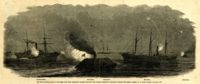
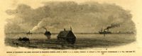
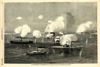
Caption: 'The War in South Carolina--the Rebel rams from Charleston Harbor attacking the Federal blockading squadron, January 31.--from a sketch by a Naval Officer.--see page 365.' Also identified in the image: Keystone State, Rebel Ram, Housatonic, Mercedita and Rebel Ram. [full date February 28, 1863.]
[Color image.] Caption (in French): 'Les troupes federales evacuant le fort Moultrie, apres avoir detruit le materiel de guerre.--D'apres les croquis de M.W.S. (Voir la Revuie de la semaine.)' [Federal troops evacuate Fort Moultrie, after destroying war materials.--from the sketch by M.W.S. (see the Review of the Week)].
Caption: 'Concert for the inmates of the Charity Hospital, Blackwell's Island.--drawn by C.E.H. Bonwill.--(see page 150.).' [full date February 14, 1874.]
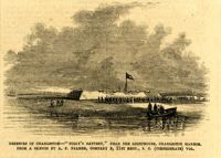
Caption: 'Defences of Charleston--the Rebel iron-clads in Charleston Harbor.--from a sketch by A.P. Palmer, formerly of Company B, 21st Regiment (Confederate) S.C. Vol.--see page 317.' [full date February 7, 1863.]
Caption: 'Defences of Charleston--"Folly's Battery," near the lighthouse, Charleston Harbor. From a sketch by A.P. Palmer, Company B, 21st Regt., S.C. (Confederate) Vol.' [full date February 7, 1863.]
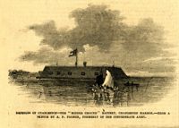
Caption: 'Defences of Charleston--the "Middle Ground" Battery, Charleston Harbor.--from a sketch by A.P. Palmer, formerly of the Confederate Army.' [full date February 7, 1863.]
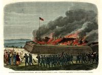
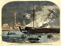
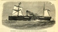
[Color image]. Caption: 'The ship "Jacob A. Wetervelt" on fire in the harbor of New York, April 11, 1860.--[see preceding page.]' [full date April 21, 1860.]
Caption: 'Cook's Earthquake Views of Charleston and Vicinity. Taken after the 31st of August, 1886. No.115, Corner [of] Market and Anson Streets.' Sign on building reads: 'Ship & Family Groceries.' Written on front, at bottom: 'Charleston Earthquake view - cor. Market and Anson sts.'
Charleston Earthquake scene. Written on reverse: 'East Battery, just below Atlantic Street. Edmonston [sic] House, later the Charles Alston residence. Now (1947) the residence of J.J. Pringle Smith. Old Holmes house on left. Earthquake of 1886 - Charleston, S.C.'
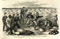
Caption: '"The Grand Skedaddle" of the inhabitants from Charleston, S.C., when threatened by an attack from the Union troops.--from a sketch by Lieut. G.P. Kirby, 47th N.Y.V., when a prisoner in Charleston.--see page 270.' [full date January 17, 1863.]
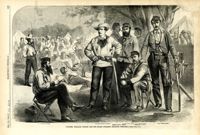
Caption: 'Colonel William Wilson and his staff (Wilson's Fighting Brigade)--[see page 311].' Identified in image: Quartermaster Bradley, Lieutenant Colonel Creighton, Adjutant James J. Hearey, Paymaster Peter Duffy, Col. William Wilson, Surgeon D.C. Pease. [full date May 18, 1861.]
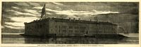
Caption: 'Firing on the "Star of the West" from the South Carolina battery on Morris Island, January 10, 1861.--[see page 54.]' [full date January 26, 1861]
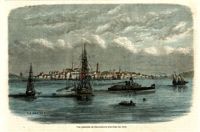
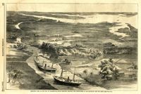
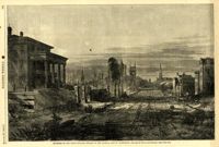
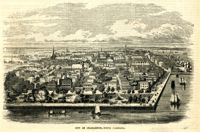
Caption: 'Birds-eye view of the city of Charleston, South Carolina, showing the approaches of our gun-boats and our army.--[see page 431.]' [full date July 5, 1862.]
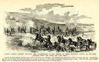
Caption: 'Captain Knapp's Battery engaging the Confederates at the Battle of Cedar Mountain, August 9th, 1862--this battery fired the first and last shot.'
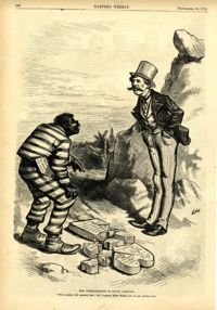
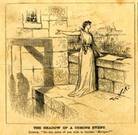
Political cartoon, caption: 'The Commandments in South Carolina. "We've pretty well smashed that; but I suppose, Massa Moses, you can get another one."' [full date September 26, 1874]
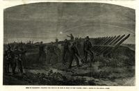
Caption: 'Siege of Charleston--planting the chevaux de frise in front of Fort Wagner.--from a sketch by our Special Artist.' [full date September 26, 1863.]
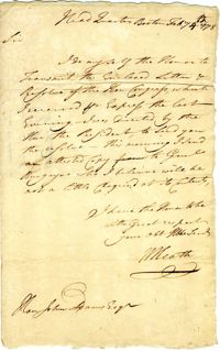
Letter from George Weedon to Nathanael Greene regarding the British evacuation of ‘Charles Towne’ and the plans of Continental Army officers for the end of the war.
Caption: 'South Carolina.--The recent earthquakes at Charleston--typical scenes of the calamity. From sketches by C. Upham--see page 71. 1. Scene on the stairway of the Charleston Hotel during a shock. 2. Taking down St. Philip's Steeple. 3. Scene on Marion Square, opposite the Citadel--a city of tents.' [full date September 18, 1886.]
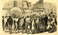
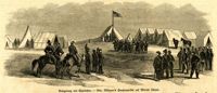
Caption: 'Enthusiastic crowd of citizens of Charleston, S.C., assembled on Vanderhost's (sic) Wharf, Feb. 20, to greet the second visit of Gen. Gillmore and staff.--sketched by our Special Artist.' [full date March 25, 1865.]
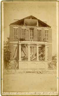
Caption: 'Cook's Earthquake Views of Charleston and Vicinity. Taken after the 31st of August, 1886. No.40, Bishop's house, Broad Street.' Handwritten at bottom, front: 'Charleston Earthquake scene - Bishop Northrup's Residence.' Charleston city directory for 1886 shows Bishop Henry P. Northrop at 114 Broad Street.
Caption: 'Cook's Earthquake Views of Charleston and Vicinity. Taken after the 31st of August, 1886. No.150, Mariner's Church, exterior." Also, handwritten at bottom of image: 'Charleston Earthquake scene - Mariners' Church, Church Street ? East Bay'
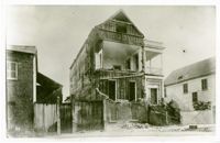
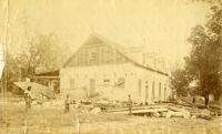
Charleston Earthquake Scene. Possibly from Cook's Earthquake Views, No.56, Alderman Murray's residence, Wentworth Street.' Charleston city directory for 1886 shows Andrew B. Murray at 175 Wentworth.
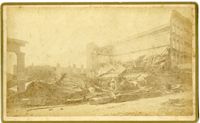
Charleston Earthquake scene. Written on front, at bottom: 'Charleston Earthquake scene - warehouse on Atlantic Wharf.' Charleston city directory for 1886 lists Atlantic Wharf at the rear of the Post Office.
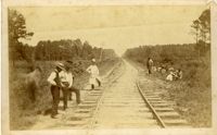
Charleston Earthquake scene. Handwritten on reverse: '9 mile bottom - South Carolina railroad - chasm on left. Track was originally a tangent. Caused by earthquake, 1886. Track cut of line.'
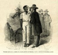
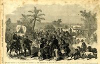
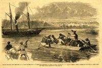
Caption: 'Negroes escaping from Beaufort, S.C., with plunder from the abandoned residences of their masters, stopped by U.S. Gunboat Seneca.--from a sketch by our Special Artist with the Great Naval Expedition.--see page 70.'
![Descriptive List of Free Negroes Belonging to City Engine No. 6 [Copy 1]](https://iiif.library.cofc.edu/iiif/2/50347/full/200,/0/default.jpg)

![Descriptive List of Free Negroes Belonging to City Engine No. 9 [Copy 1]](https://iiif.library.cofc.edu/iiif/2/50366/full/200,/0/default.jpg)