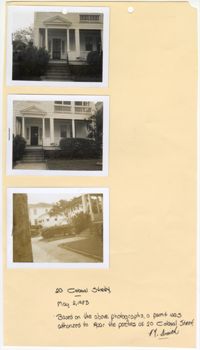
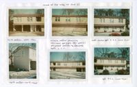
Three black and white photographs of No. 20 Colonial Street: Top (front facade/east elevation); Middle (front facade/east elevation); Bottom (front yard and sidewalk in front of structure). The photographs are stapled to a beige sheet of paper with two holes punched through the top. The paper is labeled "20 Colonial Street." There is a handwritten note on the paper explaining the purpose of the photographs. Their goal was to repair the porches at No. 20 Colonial Street. The note is signed by a "Smith." There is a white border surrounding all three photographs. The structure at No. 20 Colonial Street has a covered porch spanning the entirety of the exterior of the first story front facade/east elevation. There is a pediment held above the entryway of the porch by two Doric free standing columns. The first story is elevated with stairs leading up to the porch. There is a front yard covered in grass and an urban garden bordering the structure. There is a paved walkway to the entry stairs and a sidewalk running parallel to the street in front of the structure.
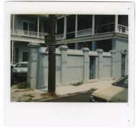
Colored photograph of No. 2 Tradd Street and No. 4 Tradd Street. There is a white border surrounding the photograph. There are eleven small holes on the right side of the photograph's border. The photograph shows two elevations of the structure. The elevations are each two stories in height with porches on exterior of the second story. There are missing balustrades in sections of the railing. The first story has window and door openings. There are piles of wood and construction supplies near the walls of the structure. There is a post in the bottom right corner of the photograph with a sign advertising "Julian V. Brandt" printed on it in blue ink. There is another identical post on the left side of the photograph. The structure's exterior and the posts are painted a light blue. There is a yard covered in sand and grass in front of the structure.
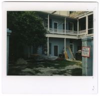
Colored photograph of No. 2 Tradd Street and No. 4 Tradd Street. There is a white border surrounding the photograph. There are four small holes on the right side of the photograph's border. The photograph shows two elevations of the structure. The elevations are two stories in height. There is a porch on the exterior of both elevations. The railing on the porch is missing in places. In front of the elevations is a thick and tall retaining wall obstructing the view of the first story. The wall has two doors within it and it is attached to the building on one side. The wall ends to allow space for cars to park in the courtyard formed by the two building elevations and the wall. The building and the wall are painted light blue. There is an electric pole in front of the wall and a yellow car parked on the opposite side of the road in the bottom right corner of the photograph.
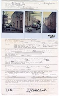
Three colored photographs of No. 34 George Street: Left (side elevation); Middle (side elevation); Right (side elevation). There is a white border surrounding each of the photographs. The photographs are stapled to a document that is proposing more meters to be added to the structure and current meters to be removed. The photographs show the side elevations where the new and current meters are to be added and/or removed. This is indicated by the handmade black markings and writing on the photographs. The document attached to the photographs note that these are the only changes proposed in this specific application.
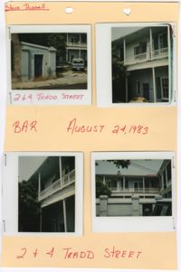
Four photographs of No. 2 Tradd Street and No. 4 Tradd Street: Top left (door in retaining wall and courtyard/driveway); Top right (north elevation); Bottom left (north elevation); Bottom right (retaining wall and north elevation). The photographs are stapled to a beige sheet of paper with two holes punched through the top. The paper is labeled "2 + 4 Tradd Street" and includes the date "August 24, 1983." There are also the labels "BAR" and "Steve Russell." The marks are handwritten in red ink. There are white borders surrounding each photograph. The photographs show the north elevation of the two story structure. There is an exterior porch on the second story. There is a thick and tall retaining wall in front of the north elevation. The wall includes doors and a large opening that leads into the courtyard and driveway.
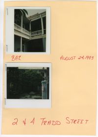
Two colored photographs of No. 2 Tradd Street and No. 4 Tradd Street: Top (corner of two elevations); Bottom (driveway/courtyard). The photographs are stapled to a beige sheet of paper. The paper is labeled "2 + 4 Tradd Street" and includes the date "August 24, 1983." There is also the label "BAR." The marks are handwritten in red ink. There are white borders surrounding each photograph. The top photograph shows the intersection of two elevations at No. 2 Tradd Street and No. 4 Tradd Street. The top story contains exterior porches connecting with each other at the corner. The exterior walls of the structure are painted a light blue. The bottom photograph shows a courtyard and driveway. It is not paved. It is covered with sand and grass. There is a large tree obstructing the view of the structure.
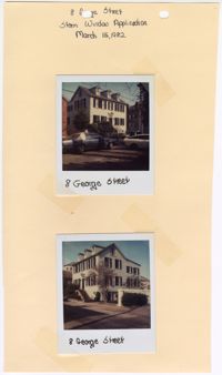
Two colored photographs of No. 8 George Street: Top (corner of front facade/north elevation and east elevation); Bottom (corner of front facade/north elevation and west elevation). There is a white border surrounding each of the photographs. The photographs are taped to a beige sheet of paper that has been hand cut. There are two holes punched through the top of the paper. The paper is labeled "8 George Street Storm Window Application" and lists the date, "March 15, 1982." The structure at No. 8 George Street is a two-and-a-half story Federal style structure. The pitched roof has three dormer windows projecting from the front facade that are symmetrical with the front of the structure. The first and second stories have five symmetrical openings. The front door on the first story is in the very center of the structure. There is a pediment above the front entryway. There are brick stairs leading to the platform that accesses the front door. The side elevation shows a symmetrical structure under the pitched roof. There is more to the structure that projects behind the structure that breaks that symmetry from a side angle.
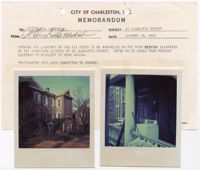
Two colored photographs of No. 20 Charlotte Street: Left (west elevation); Right (porch). The top of the photographs are taped to a beige sheet of paper titled "City of Charleston, S.C. Memorandum." The bottom of the photographs are hanging from the paper. The paper the photographs are taped to state the purpose of the photographs as showing where the existing meter on the structure is and where they were proposing to move it. The photograph on the left shows a distant perspective of the west elevation of the structure. The photograph on the right shows a close up perspective of the porch on the structure with an appliance, which appears to be a washing machine, sitting outside the structure on the porch.
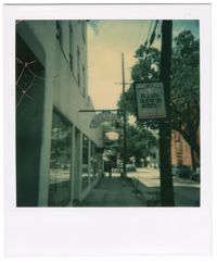
Colored photograph of the signage at No. 39 George Street. There is a white border surrounding the photograph. There are four small holes on the left side of the photograph where a staple once was. The back of the photograph labels this photograph as "39 George St." The photograph was taken by "B. Ditmore." The stated purpose of the photograph, as written on the back, was a violation for displaying signage without city approval. The photograph shows the sign for "Rainbows End" in the shape and color of a rainbow hanging over the sidewalk. The structure of No. 39 George Street appears to be a multi-story commercial structure. There are multiple openings on the first floor of the structure. Other business' signage can be seen behind No. 39 George Street, as well as trees, electrical lines, and neighboring structures.
Colored photograph of the signage at No. 39 George Street. There is a white border surrounding the photograph. There is a staple in the top left corner of the photograph. The back of the photograph labels this photograph as "39 George St." The photograph was taken by "B. Ditmore." The stated purpose of the photograph, as written on the back, was a violation for displaying signage without city approval. The photograph shows the sign for "Rainbows End" in the shape and color of a rainbow hanging over the sidewalk. The structure at No. 39 George Street appears to be a multi-story commercial structure. There are multiple openings on the first floor of the structure. Other business' signage can be seen behind No. 39 George Street, as well as trees and electrical lines.
Two colored photographs of No. 38 Charlotte Street: Top (angled perspective of side elevation); Bottom (blurry photograph of side elevation). The photographs are taped to a beige sheet of paper with two holes punched through the top. The paper is labeled "38 Charlotte St." There is a white border surrounding both photographs. There is a description of the photographs handwritten next to each of them. The purpose of the photographs was to show the current and proposed location for meters on No. 38 Charlotte Street. The paper is signed and dated.
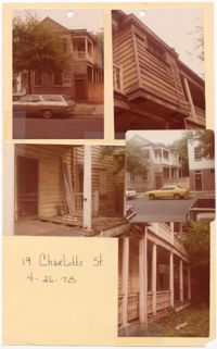
Five colored photographs of No. 19 Charlotte Street: Top left (front facade/south elevation); Top right (close up of second story feature); Middle left (covered porch on east elevation); Middle right (corner of front facade/south elevation and east elevation and neighboring structure); Bottom right (two story piazza). The photographs are taped to a beige sheet of paper with two holes punched through the top. The paper is labeled "19 Charlotte St. 4-26-78." The structure at No. 19 Charlotte Street is a two-and-a-half story Charleston Single style structure with a two story piazza. The exterior of the structure is in disrepair. The paint is flaking from the horizontal wooden paneling. There are floorboards missing on the piazza. There is a large wooden board blocking entrance into the driveway.
Six colored photographs of the outbuilding at No. 48 Bull Street: Top left (north section); Top middle (middle section); Top right (south section); Bottom left (side elevation of north section); Bottom middle (middle section); Bottom right (middle and south section). The six photographs are attached to a white paper. There is a white border surrounding all six photographs. The paper is labeled "views of rear bldg. 48 Bull St." The outbuilding consists of horizontal exterior clapboard paneling and a red tin roof. There are large window openings on the second story and large garage doors on the first story.
A pamphlet containing the Rules and Regulations of the Board of Adjustment Under the Zoning Ordinance of the City of Charleston; the 1921 Act of the General Assembly of South Carolina Providing for a Zoning Ordinance; and the 1931 Zoning Ordinance of the City of Charleston.
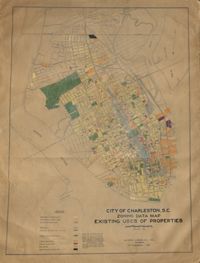
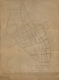
Hand-colored, linen map showing Charleston peninsula existing lot uses from Murray Boulevard to the northern limits of the city at Mount Pleasant Road. Map shows one, two, and multiple dwelling units, service stations, garages, industrial sites, and railroads. Information on map was compiled during field observations made from October through December 1930. Map measures 46.25" by 63."
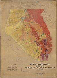
Hand-colored, linen map showing proposed height and area districts for the city of Charleston. Map shows eight height and area districts from Murray Boulevard to the northern limits of the city at Mount Pleasant Road. Map measures 42" by 60".
Linen map showing distribution of schools in Charleston from Murray Boulevard to the northern limits of the city at Mount Pleasant Road. Map shows school district lines, developed and undeveloped school properties and racial population disbursement indicated by white circles for white residents and black circles for black residents. Map is found on page 11 of the Report of the City Planning and Zoning Commission. Map measures 41.25" by 59".
Linen map showing existing and proposed parks; thoroughfares; schools; residential, business, and industrial districts; and suggested streets from Murray Boulevard to the northern limits of the city at Mount Pleasant Road. Residential districts are identified by racial makeup and labeled as white residence and colored residence districts. Map is found on page 11 of the Report of the City Planning and Zoning Commission. Map measure 41" by 59".
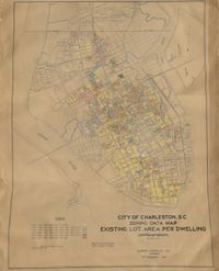
Hand-colored, linen map showing Charleston peninsula existing lot area per dwelling from Murray Boulevard to the northern limits of the city at Mount Pleasant Road. The maps shows lots less than 1,000 square feet; lots more than 1,000 square feet and less than 1,500 square feet; lots more than 1,500 square feet and less than 2,500 square feet; lots more than 2,500 square feet and less than 3,000 square feet; lots more than 3,000 square feet and less than 4,500 square feet; and lots greater than 4,500 square feet. Map measure 47" by 63".
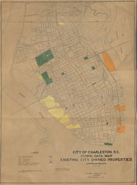
Hand-colored, linen map showing existing city properties including parks, playgrounds, port utilities, public buildings, fire stations, municipal service properties, and miscellaneous properties from Murray Boulevard to the northern limits of the city at Mount Pleasant Road. Map measures 42" by 60".
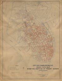
Hand-colored, linen map showing Charleston peninsula existing depths of front yards (5 feet and under, 6 to 14 feet, 15 to 24 feet, 25 feet and over). Map reflects Murray Boulevard to the northern limits of the city at Mount Pleasant Road. Map measures 47" by 63".
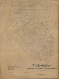
Hand-colored, linen map showing Charleston peninsula heights of buildings from Murray Boulevard to the northern limits of the city at Mount Pleasant Road. Height in stories is indicated by color coding. Map shows buildings of three stories or more. Map measures 42" by 60".
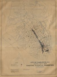
Hand-colored, linen map showing Charleston peninsula existing business properties, public garages, and gasoline service stations from Murray Boulevard to the northern limits of the city at Mount Pleasant Road. Map measures 46.75" by 63".
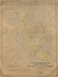
Hand-colored, linen map showing Charleston peninsula lot occupancy from Murray Boulevard to the northern limits of the city at Mount Pleasant Road. Map is color coded to show lot occupancy percentages on the peninsula. Map measures 46.5" x 63".
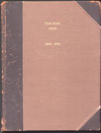
The 1880-1930 Year Book Index for the City of Charleston is an alphabetical list of subject and name entries pointing to the individual City of Charleston Year Books published between 1880 and 1930. The bound volume includes two separate indexes. The first is a published 1880 to 1901 index compiled by George H. Holmes of the Charleston Bar Association and printed locally by Lucas-Richardson Lithograph and Printing Company. The 1900 to 1930 index was compiled by Joseph C. Barbot, Clerk of Council. The Barbot index was never published and appears in typewritten manuscript form with handwritten corrections and editions.
The 1896 Olmsted, Olmsted, and Eliot report commissioned by Charleston for the board of park commissioners. The report was created after the group's second visit to Charleston. This is the first report of many as the Parks Commissioners worked in tandem with the Olmstead group up through the twentieth century. The report outlines advice for the advancement of downtown Charleston's parks, general aesthetics, and public roadways. The projects outlined in the report are: Battery Park, Waterfront park, Ashely Ave, Chicora Parkway, and Chicora Park.
Three colored photographs of No. 32 Bull Street: Top (front facade with vehicle parked in front of the building); Bottom left (southeastern corner of building with vehicle parked in front); Bottom right (elevation with vehicle parked to the left). The three photographs are stapled to a beige paper with two holes punched through the top. The holes partially remove the label, however, the label of the folder can still be read as "32 Bull Street 8211-29-8." The structure is a two-and-a-half-story structure. The photograph shows a red gable roof and an exterior consisting of white horizontal paneling. There are hand-drawn black marks on the top photograph. These marks include a circle near the roof and an arrow above the photograph pointing downwards towards it. The arrow is labeled as "location."
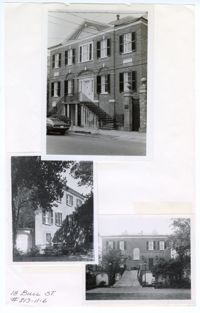
Three black and white photographs of No. 18 Bull Street: Top (front façade facing south on Bull Street); Middle (side elevation); Bottom (rear south elevation). The three photographs are taped to a beige colored paper. The photographs are overlaid on top of each other. There is a white border around each of the photographs. The paper is labeled "18 Bull St. #813-11-6." The structure is a three-story Adamesque style structure made of brick construction. The structure has a pitched roof with an elevated Palladian entryway and centered front and back door. The middle and bottom photographs show the side and back of the structure with trees in front of the structure and a yard.
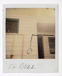
Colored polaroid photograph of east elevation of No. 56 Bull Street. The photograph shows the exterior with white horizontal paneling and green framing around the openings of the structure, mainly windows and doors. The area of the structure on the right is setback. The area to the left has pipes running horizontally and vertically on the exterior. There are black markings of a horizontal line coming from the right side of the photograph which then runs vertically in the center of the photograph and is ended with a circle.
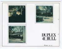
Three colored photographs of No. 41 Bull Street: Top Left (elevation); Top Right (front facade/south elevation facing Bull Street); Bottom Left (front facade/south elevation facing Bull Street). The three photographs are taped to a thick white board with two holes punched through the right of the board. There is a thin black line adjacent to the edges of the board. The board is labeled as "Duplex 41 Bull #801-10-2." The structure is one-story brick construction. The top left photograph shows the white exterior of the duplex with a tree and shade. The top right photograph shows a tree and car in front of the structure. The bottom left photograph shows two trees in front of the structure.
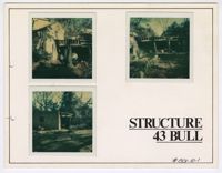
Three colored photographs of the rear of No. 43 Bull Street: Top left (outbuilding and cement block structure); Top right (cement block structure); Bottom left (cement block structure). The three photographs are attached to a white board with a thin black line lining the edges. There are two holes punched in the border on the left. There is a white border surrounding all three photographs. The board is labeled as "Structure 43 Bull." There is a handwritten note that identifies the board as "#801-10-1." The cement block structure is detached from the main structure.
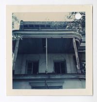
Colored photograph of the second story balcony on the south elevation of No. 43 Bull Street. The photograph has a white border and a hole in the top right corner. The close up photograph shows the second story balcony in disrepair. The railing and ornamentation are missing on this section of the balcony. Sections of the ceiling are missing. There are cracks on the walls.
Colored photograph of the second story balcony on the south elevation of No. 43 Bull Street. The photograph has a white border and a hole punched through the top right corner. The close up photograph shows the second story balcony in disrepair. The railing and ornamentation are missing on the rounded section of the balcony.
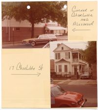
Two colored photographs of No. 17 Charlotte Street: Top left (structure located at the corner of Charlotte Street and Alexander Street); Bottom right (corner of front facade/south elevation and east elevation). The photographs are taped to a beige sheet of paper with two holes punched through the top. The photograph of No. 17 Charlotte Street is labeled "17 Charlotte St." The photograph of the neighboring structure is labeled "Corner of Charlotte and Alexander." The structure at No. 17 Charlotte Street is a two-and-a-half story Charleston Single style structure with a two story piazza. The exterior of the structure consists of white horizontal paneling with a pitched roof. The first story exterior of the facade includes a bay window with a sloped roof. The entryway leading onto the piazza is covered by a curved covering above the door. There is a transom above the entryway door and below the covering.
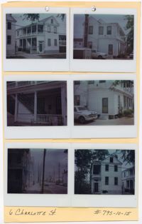
Six colored photographs of No. 6 Charlotte Street: Top left (corner of front facade/north elevation and east elevation); Top right (corner of south elevation and east elevation); Middle left (close up of two story piazza and exterior stairs); Middle right (close up of the corner of south elevation and east elevation); Bottom left (corner of front facade/north elevation and east elevation showing the street in front of the structure); Bottom right (front facade/north elevation). The photographs are taped to a beige sheet of paper with two holes punched through the top. The paper is labeled "6 Charlotte St." and "#795-10-15." There is a white border surrounding all six photographs. The structure at No. 6 Charlotte Street is a two-and-a-half story Charleston Single style structure with a two story piazza to the left of the front facade. The structure has a pitched roof and white horizontal exterior paneling. The framing of the openings are painted blue. Both levels of the piazza in the back of the structure are enclosed. There is a covering above the entryway held up by two brackets. There is an oval window below the covering.
Colored photograph of the front facade/south elevation of No. 37 Charlotte Street. The photograph itself as rounded edges. The back of the photograph is labeled "37 Charlotte" and requests that the photograph be returned to the owners. The photograph shows a two story duplex structure. The roof is red and the exterior horizontal paneling is white. The center of the structure is projecting outwards creating two large porches in the center of the structure on both the first and second stories. The second story porch is supported by two sets of two Ionic columns, whereas the first story porch is supported by two sets of two Doric columns. The entryways to the building are on either side of the porches. There is a curved covering and fanlight above both front doors. The structure is elevated. Brick stairs lead to the front doors. The structure is entirely symmetrical.
Colored photograph of the rear of No. 33 Charlotte Street. There is a white border surrounding the photograph. The back of the photograph is labeled as "33 Charlotte." The photograph shows a driveway leading to the outbuildings and backyard of No. 33 Charlotte. There are metal stairs on the left side of the photograph. The closest outbuilding is two stories. There is a covered porch on the left side of the second story. There is also a covered colonnade on the first story supported by four columns. There is a car parked in front of the structure. The view of the second outbuilding is partially obstructed by the large oak tree in the backyard. The second outbuilding does have a porch extending from the second story. The backyard is located to the right. The backyard is surrounded by a metal fence with brick posts signaling the entryway through the metal gate. The other fence posts are concrete. There is a cat standing in the middle of the driveway.
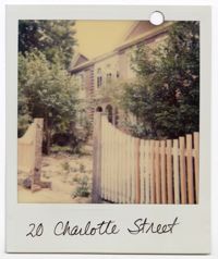
Colored photograph of the east elevation of No. 20 Charlotte Street. There is a white border surrounding the photograph with one hole punched through the top right corner. The photograph is labeled "20 Charlotte Street." The photograph shows the side elevation of the two story brick structure. There are two pitched roofs on either side of the elevation. On the first and second stories in the area between the pitched roofs, the exterior corners are lined with brick quoins. The area in the center has three openings on both the first and second stories. The second story consists of three arched windows while the first story consists of three arched entryways. There is a fence blocking the sidewalk from the property. There is not a gate in the opening of the fence. There are trees beyond the fence that obstruct the rest of the view of the structure.
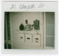
Colored photograph of multiple meters on the exterior of No. 21 Charlotte Street with four small holes punched through the top center of the border. The photograph is labeled "21 Charlotte St." The meters are all connected to each other. They are positioned between two openings of the structure on the exterior wall. The exterior wall consists of white horizontal paneling. The two openings are glass with sashes separating the panes. The windows are not identical and have a different number of window panes. Inside the structure and behind the windows, one window is covered with a curtain and the other with blinds.
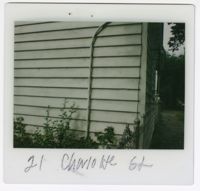
Colored photograph of an exterior corner of No. 21 Charlotte Street. There is a white border surrounding the photograph with two small holes punched through the top center of the border. The photograph is labeled "21 Charlotte St." The photograph shows the horizontal exterior paneling and a pipe running vertically along one of the elevations. There is a fence extending from the wall of the structure. Behind the fence and along the structure, there are plants.
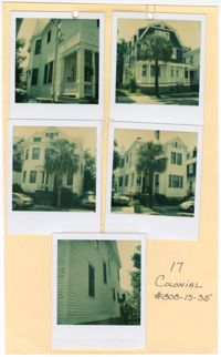
Five colored photographs of No. 17 Colonial Street and neighboring structures: Top left (north elevation of No. 17 Colonial Street); Top right (front facade/west elevation of the neighboring structure at No. 19 Colonial Street); Middle left (front facade/west elevation of the neighboring structure at No. 15 Colonial Street); Middle right (front facade/west elevation of No. 17 Colonial Street); Bottom (south elevation of No. 17 Colonial Street). The photographs are taped to a beige sheet of paper with two holes punched through the top. The paper is labeled "17 Colonial #808-13-35." There is a white border surrounding all five photographs. The structure at No. 17 Colonial Street is a two-and-a-half story structure with white horizontal exterior paneling. The neighboring structure at No. 15 Colonial Street is also a two-and-a-half story structure with white horizontal exterior paneling. Where the front facade is flat on No. 17 Colonial Street, there is a bay window at No. 15 Colonial Street. The neighboring structure at No. 19 Colonial Street is a three story Shingle style structure with a gambrel roof and dormer windows. The exterior siding consists of blue shingles on the third and second stories. The first story has white horizontal exterior paneling and a covered porch spanning the entire first story exterior.
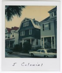
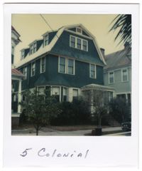
Colored photograph of the structure at No. 5 Colonial Street. The photograph has a white border with the label "5 Colonial" handwritten on the bottom half of the white border. The photograph was taken from across the street. Vehicles are visible parked on both sides of the street. The structure at No. 5 Colonial Street is a three-story Shingle style structure with a gambrel roof and dormer windows. The exterior siding consists of blue shingles on the third and second stories. The first story has white exterior paneling. There is a bay window on the left of the front facade/west elevation and a covered porch to the right. There is foliage obstructing the view of the first story. The neighboring structures to each side of No. 5 Colonial are visible in the photograph.
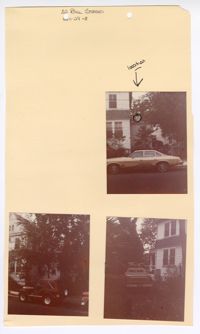
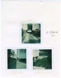
Three colored photographs of No. 10 Colonial Street: Top (parked vehicle in driveway); Bottom left (corner of west elevation and driveway); Bottom right (corner of south elevation and back yard). The three photographs are taped to a beige sheet of paper with two holes in the top. The paper is labeled as " 10 Colonial St." There is a white border surrounding all three photographs. The top photograph shows the north elevation of No. 10 Colonial Street and the south elevation of neighboring structure. The driveway is paved under where the tires of the vehicle sit. The center and sides of the driveway consist of grass. The bottom left photograph shows the back corner of the structure with a projecting bay window on the north elevation. The yard is covered in grass and lined with foliage along the border of the property in both of the bottom photographs.
Colored photograph of the structure at No. 5 Colonial Street. The photograph has a white border with the label "5 Colonial" handwritten on the bottom half of the white border. The structure at No. 5 Colonial Street is a three-story Shingle style structure with a gambrel roof and dormer windows. The exterior siding consists of blue shingles on the third and second stories. The first story has white horizontal exterior paneling. There is a bay window on the left of the front facade/west elevation and a covered porch to the right. There is foliage obstructing the view of the first story. The neighboring structures to each side of No. 5 Colonial are visible in the photograph.
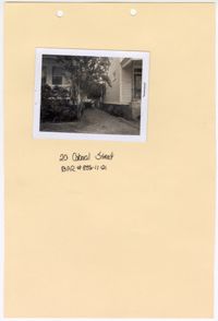
Black and white photograph of No. 20 Colonial Street. The photograph is stapled to a beige sheet of paper with two holes punched through the top. The paper is labeled "20 Colonial Street BAR #835-11-21." There is a white border surrounding the photograph. The photograph shows a gravel path in between No. 20 Colonial Street and the neighboring structure to the right. The corner of the front facade/east elevation of No. 20 Colonial Street is visible as well as the corner of the front facade/east elevation and south elevation of the neighboring structure. There is foliage obstructing the view of the exterior of the first floor of No. 20 Colonial Street.
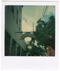
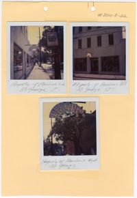
Three colored photographs of No. 34 George Street: Top left (business signage and south elevation); Top right (south elevation); Bottom (signage). There is a white border surrounding each of the photographs. The photographs are taped to a beige sheet of paper that is labeled "#8010-8-22." The photographs show the south elevation of the structure at No. 39 George Street. The elevation has multiple openings on the upper stories of the structure, all of which are windows. The first story has three large openings. There is the front entryway with double doors. On either side of the entryway are two large windows displaying objects. The photograph shows the sign for "Rainbows End" in the shape and color of a rainbow hanging over the sidewalk.
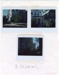
Three colored photographs of No. 3 Colonial Street: Top left (corner of front façade/west elevation and north elevation); Top right (front façade/west elevation and the southeastern corner of No. 5 Colonial Street); Bottom (side elevation). The photographs are taped to a white sheet of paper. The paper is labeled "3 Colonial" and "10-24-79." The exterior consists of white horizontal paneling. There is a bay window on the second story of the northeastern corner of the structure. Below the window on the first story is a covered porch with four free standing columns. Stairs lead onto the porch of the elevated first story. The front yard is covered in grass and shrubs. A sidewalk runs through the edge of the front yard. The neighboring structure located at No. 5 Colonial Street is visible in the top right photograph.
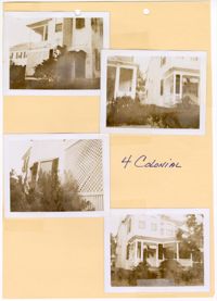
Four black and white photographs of No. 4 Colonial Street: Top left (side elevation); Top right (corner of front façade/east elevation and south elevation and neighboring structure); Bottom left (side elevation); Bottom right (corner of front façade/east elevation and south elevation). Each photograph is surrounded by a white border. The photographs are taped to a beige sheet of paper with two holes punched through the top. The paper is labeled as "4 Colonial." The two story structure has a porch spanning the majority of the exterior of the first story on the front facade/east elevation. The structure is slightly elevated with stairs leading up onto the first story front porch. There is foliage bordering the exterior of the structure on all sides.
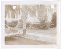
Black and white photograph of No. 4 Colonial Street. There is a white border surrounding the photograph with two holes punched through the top. The photograph shows the corner of the east elevation and the north elevation of the structure, as well as the neighboring structure to the left. The structure is elevated from the ground with a porch on the first story. The front yard is covered with grass and an urban garden bordering the structure. The sidewalk cuts through the edge of the front yard. There is a palm tree obstructing the view of the structure. There is a car parking in the bottom left corner of the photograph.
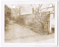
Black and white photograph of a wall located at No. 4 Colonial Street. There is a white border surrounding the photograph with two holes punched through the top. The photograph shows the retaining wall facing the north elevation of the structure at No. 4 Colonial Street. The wall separates No. 4 Colonial Street and No. 2 1/2 Colonial Street. The window of No. 2 1/2 Colonial Street can be seen behind the retaining wall in the photograph. There is grass covering the side yard with plants and trees planted along the retaining wall. A sidewalk is visible in the bottom of the photograph.