Search Home
Search in
search for
Simple Search
Page Content Search
Title Search
Creator Search
Subject Search
Search
search icon
Search
Search Constraints
Start Over
You searched for:
Media Type
Maps
✖
Remove constraint Media Type: Maps
Date Range (beta)
Unknown
✖
Remove constraint Date Range (beta): Unknown
1
-
70
of
70
Sort
by Relevance
Relevance
Title
Date (Newest)
Date (Oldest)
Number of results to display per page
100
per page
10
per page
20
per page
50
per page
100
per page
View results as:
list icon
List
masonry icon
Masonry
Search Results
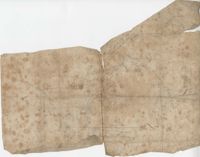
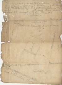
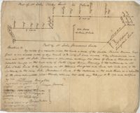
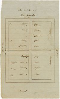
Charleston Farm Plat
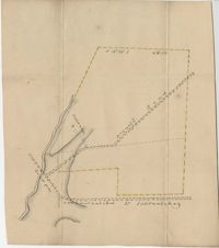
Hickory Hill Plat
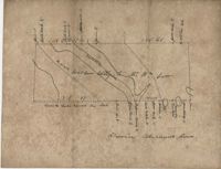
Bennett and Cambel Plat
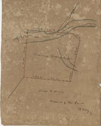
Prince Frederick Parish Plat 1789
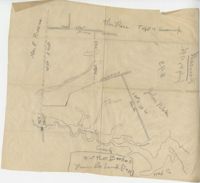
Plat Off of Dorchester Road
St. John's Parish Plat
Stono Plat
Chisolm Plat
St. Peter's Parish Plat
Downes' Stono Plat
Pee Dee River Plat
Cypress Swamp Plat
Marsh Field Plantation Plat
Savannah River Plat
Plat of Johns Island near Exchange
St. Andrew's Parish Plat
Jordan Plat
Hopewell Plantation Plat 1805
Santee River Plat
Prince William's Parish Plat
St. George's Parish Plat
Jones' Goose Creek Plat
Pee Dee River Plat
Three Mile Head Plat
St. John's Parish Plat
Goose Creek Plat
Inverness Plat
Plat of Two Tracts in Colleton County
Dorchester Plat
Georgetown Plat 1787
Master's Plat
St. Bartholomew's Parish Plat
Pocotaligo River Plat
Colleton County Plat
Belle Island Plat
Egan Hall Plat
St. George Parish Plat
Colleton County Plat
Santee River Plat
St. James Parish Plat
Washo Plantation Plat
Cooper River Plat
St. John's Parish 1789
St. George's Parish Plat
Santee River and Wambaw Creek Plat
Carson Plat
Goose Creek Plat
Turtle Island Plat
St. John's Parish Plat
Fairfield Plantation Barnyard Garden Map
South Edisto River Plat
Georgetown District Plat
Wadmalaw Island Plat
Augusta Road Plat
Liott Plat
Fairfield Plantation Garden Map
Sandy Island Plat
Ansonborough Beautification Plans
Map of the Ansonborough Rehabilitation Project
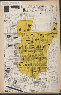
Ansonborough Historic District As Established in the Charleston City Ordinance of 1966
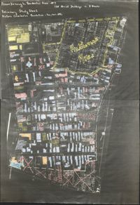
Ansonborough Rehabilitation Project
Ansonborough map
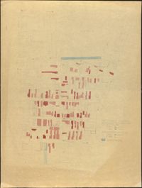
Preliminary Study Sheet
City Engineers's Plat Book, 1671-1951, Page 254
City Engineers's Plat Book, 1671-1951, Page 111
City Engineers's Plat Book, 1671-1951, Page 126
City Engineers's Plat Book, 1671-1951, Page 193
City Engineers's Plat Book, 1671-1951, Page 44
City Engineers's Plat Book, 1671-1951, Page 203
City Engineers's Plat Book, 1671-1951, Page 214
Limit your search
Collection
John McCrady Plats and Deeds Collection
55
City Engineers's Plat Book, 1671-1951
7
Ansonborough Rehabilitation Project
6
Fairfield Plantation Papers
2
Contributing Institution
South Carolina Historical Society
55
The Charleston Archive at CCPL, City of Charleston
7
Historic Charleston Foundation
6
College of Charleston Libraries
2
Media Type
Maps
✖
[remove]
70
Subject (Topic)
Conveyancing--South Carolina, Maps, Surveying--South Carolina
55
Cadastral maps, Surveys
7
Historic preservation--South Carolina--Charleston, Neighborhoods--Conservation and restoration--South Carolina--Charleston, Neighborhood planning--South Carolina--Charleston
3
Neighborhoods--Conservation and restoration--South Carolina--Charleston, Historic buildings--Conservation and restoration--South Carolina--Charleston
2
Slavery, Gardens, Orchards, Plantations--South Carolina--Georgetown County--History
2
Neighborhoods--South Carolina--Charleston
1
Subject (Geographic)
Charleston (S.C.)
15
Santee River (S.C.)
5
Edisto River (S.C.)
4
Beaufort District (S.C.)
2
Dorchester (S.C.)
2
Georgetown (S.C.), Waccamaw River Valley (N.C. and S.C.)
2
Goose Creek (S.C.)
2
Johns Island (S.C.)
2
Pee Dee River (N.C. and S.C.)
2
Ashley River (S.C.)
1
more
Subject (Geographic)
»
Date
30-Sep
1