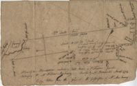
"Plan of a Plantation containing 240 acres in St. Andrew’s parish belonging to William Newbenny. Surveyed by N. Brandwill March 1772. Copy taken from the plan in the property of William Newbenny." The plat also contains the location of a structure and a road leading to it. Plantation located on East side of Ashley River. Names associated with this plat are William Mewhening, N. Brandwill, Whitenarth Tuller, William Scotts, Ralph Izard, the Lords Proprietors, William Williams and William Scott.
Plat of 250 acres on Wadmalaw Creek. Includes short explanation, but plat itself includes very little details. Names associated with this plat are Hugh McDowel, James McDowel, James Carson, Dalziel Hunter, James Young and Ellis.
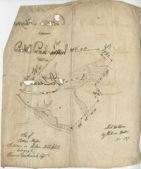
Plan of Cotton Hope Plantation on Hilton Head Island with no acreage included. Details include a marsh, swamp, and surrounding lands. Names associated with this plat are Hugh McDowel, William Horton, and Thomas Rorksdale.
Copy of a plan of 195 acres of land near the Cooper River including dams, a house, marsh and saw pit. Names associated with this plat include Mary Rupell, Robertson, Atkin, Dr. Brabangs, Withers, Jenson, Lanue and G. Arch.
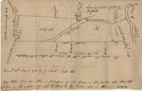
Plat to identify the boundaries between John Harleston, Elias Ball's property. West branch of Cooper River. Names associated with this plat are Joseph Purcell, John Harleston, Elias Ball and John Ward. Notable geographic locations include the Cooper River and St. John's Parish.
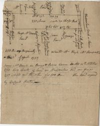
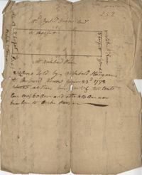
222 acres sold by Archibald Stanyarn to Andrew Down in 1772. Reverse side includes notes on various conveyances. Names associated with this plat are Archibald Stanyarn, Andrew Down, J. Williamson, Edmond Bellizer, Thomas Cliffon, Kewn [?], David Joomer [?] and Henry. Notable geographic locations include Colleton County and Stono River.