Collection Thumbnail Image
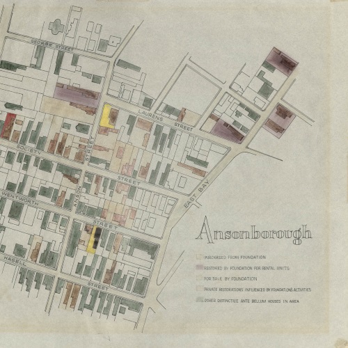
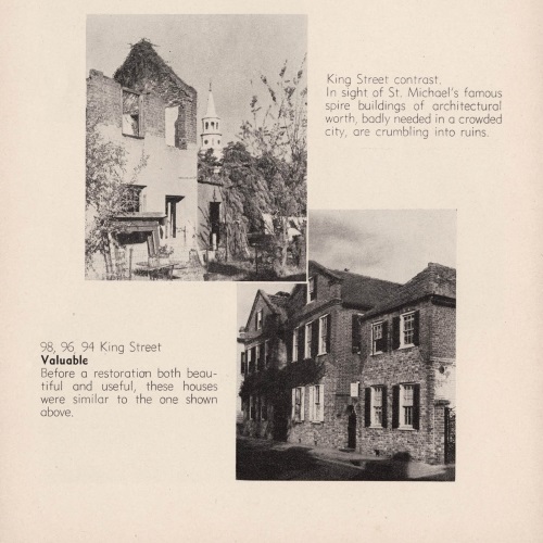
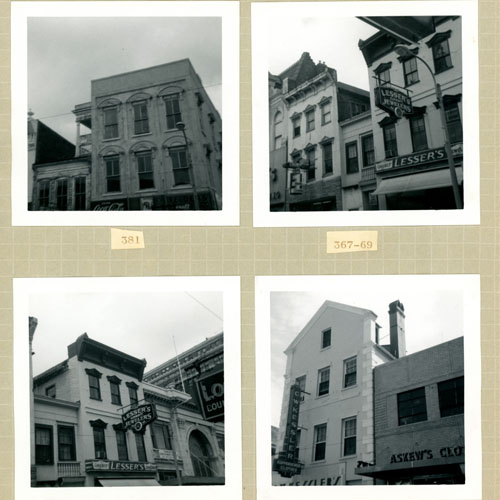
1967 King Street Survey Collection

In 1967, Historic Charleston Foundation was deeply concerned about the conditions of the downtown area, particularly the commercial blocks of King Street. Because the Foundation believed that the survival of King Street as a thriving retail shopping district was vital, it launched a feasibility study to determine the potential of the area. The study examined […]

Collection Thumbnail Image
Ansonborough Rehabilitation Project

In the 1950s many houses in Ansonborough were threatened with ”demolition by neglect,” having stood vacant or fallen into severe disrepair. In order to encourage homebuyers to move into the neighborhood to save these formerly unwanted treasures, Historic Charleston Foundation (HCF) was the first organization in the country to develop the Revolving Fund as a […]

Collection Thumbnail Image
Charleston City Records Collection

The Charleston Library Society’s copy of the City of Charleston’s 1931 Report of the City Planning and Zoning Commission Upon a Program for the Development of a City Plan with Specific Studies of Certain Features Thereof was prepared for the city by Morris Knowles, Inc. The report contributes to the growing work surrounding the acknowledgement of race-based […]

Collection Thumbnail Image
City of Charleston, SC, Report of the City Planning and Zoning Commission, Zone Maps

This collection consists of ten maps that were produced in conjunction with the preparation of the City of Charleston’s 1931 Report of the City Planning and Zoning Commission Upon a Program for the Development of a City Plan with Specific Studies of Certain Features Thereof. The report, prepared by Morris Knowles, Inc., paved the way […]

Collection Thumbnail Image
Civic Services Committee Papers

The Civic Services Committee (CSC) (1942-1946) was the predecessor body to Historic Charleston Foundation. It was formed by the Carolina Art Association to address the need for architectural preservation and to implement city planning in response to growth. The Committee received grants from the Rockefeller Foundation and Carnegie Corporation, which were used to retain Frederick […]

Collection Thumbnail Image
Colleton County Memorial Library Map Collection

The Colleton County Memorial Library Map Collection currently contains a sampling of images from the historic maps in the holdings of Colleton County Memorial Library.  Included in this collection is the Jonah Horry Book of Maps, which features maps, surveys and charts drawn by John Goddard and John Horry Dent.

Collection Thumbnail Image
Gertrude Sanford Legendre Papers, 1836-2000

Gertrude Sanford Legendre (1902–2000) was an American socialite who served as an OSS operative during World War II. She was also a noted explorer, big-game hunter, environmentalist, and owner of Medway plantation in South Carolina. The collection includes scrapbooks of Gertrude’s travels and family life, loose photographs ranging in date from the mid to late […]

Collection Thumbnail Image
Henry Mouzon Plat Book, 1769-1819

This item is a surveyor’s duplicate book of plats attributed to noted surveyor, civil engineer, and map maker Henry Mouzon. Mouzon conducted surveys for the first map drawn to scale of North and South Carolina, which was published in London in 1775. This book includes an index to the names of property owners and the […]

Collection Thumbnail Image
Historic Charleston Foundation Tours of Homes

One of the first fundraising programs developed by Historic Charleston Foundation after its incorporation in 1947 was its annual spring tours of historic houses, during which trained “hostesses” would guide visitors through several private homes in Charleston’s historic district. In addition to raising revenue to support Historic Charleston Foundation’s preservation efforts, the tours performed an […]

Collection Thumbnail Image
John McCrady Plat Collection, 1696-1924

This collection primarily consists of over two hundred eighteenth and nineteenth century plats pertaining to properties in the Lowcountry region of South Carolina. Plats include the parish of St. Thomas & St. Denis, St. Andrew’s Parish, Prince Frederick, St. Stephen’s Parish, St. Luke’s Parish, St. Peter’s Parish, St. John’s Parish, St. Bartholomew’s Parish, St. Paul’s […]

Collection Thumbnail Image
Lawrence Layden Scrapbook, 1941-1945

The Lawrence Layden Scrapbook contains photographs and papers documenting his wartime service. Lawrence Layden was a Captain in the 67th Tactical Reconnaissance Group during World War II. Personal papers consist of induction papers, forms listing the date for reverting to inactive service, military security passes, promotion papers, transfer papers, letters of recommendation to attend Officer Candidate […]

Collection Thumbnail Image
Middleton Family Art Work, 1803-1867

A ten-set collection containing 37 items of measured drawings, ink sketches, pencil drawings and watercolors representing several generations of the Middleton family of South Carolina from 1803-1867. Sets 1-6 contain measured architectural drawings attributed to John Izard Middleton with dates and watermarks ranging from 1808-1813. Five country houses and one greenhouse are depicted in these […]

Collection Thumbnail Image
Mitchell King Atlas, 1662-1695

This collection of 17th century world maps was published and printed by the Danckerts family, and was donated as a part of the Mitchell King Library. These 31 maps cover various countries in Europe, as well as the continents of Asia, Africa, and North and South America. The maps are by various cartographers including Visscher, […]

Collection Thumbnail Image
Simons and Lapham Architectural Drawings, 1919-1952

Architectural drawings from the firm of Albert Simons and Samuel Lapham. Includes measured drawings of a country club in Ohio by Samuel Lapham; designs of the Ashley River Memorial Bridge; sculpture pedestals for the Gibbes Museum of Art; sundials, and garden plans.

Collection Thumbnail Image
Slave Records in the Discrete Manuscript Collection

The selected manuscripts date from as early as 1774 and contain evidence of the lives and experiences of enslaved persons in South Carolina. The items include bills of sale, plantation ledger lists, land plats, court records, family papers, correspondences, labor contracts, last will and testaments and estate records. These manuscripts have proven essential in genealogical […]

Collection Thumbnail Image
U.S. Engineer Maps of the Waccamaw River, 1903

This collection contains five maps of the Waccamaw River in Horry County, S.C. from Conway to Bull Creek dated November 1903. The surveys were performed under the direction of Captain G. P. Howell, Corps of Engineers U.S.A. and Reid Whitford, U.S. Assistant Engineer. The surveyor was William H. Johnstone. These five maps show the soundings […]

Collection Thumbnail Image
William Henry Johnson Scrapbook

This scrapbook by William Henry Johnson is part of a collection three, which document the history of a large array of Lowcountry plantations and places of interest. In this book – compiled, 1928-1932 – Johnson focuses on the Cooper River region and in the Parishes of St Stephen, St James Goose Creek, St James Santee […]