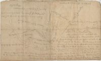
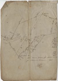
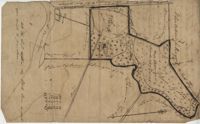
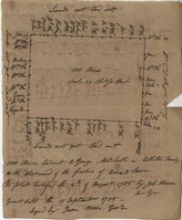
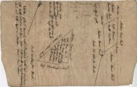
A collection of five maps and three charts describing land owned by Jonah Horry in South Carolina. The first four maps were drawn from surveys made by John Goddard in 1793; the last map was drawn from a survey made by John Horry Dent in 1836.
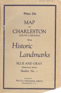
Map of the Charleston peninsula featuring points of interest. Cover title: Map of Charleston, South Carolina with historic landmarks. Blue and gray historical series, booklet no. 1. Published by Wil-Tuc Advertising Agency. Map measures 21” x 6.25” folded to create 13 pages measuring 6.25” x 3.5.
Linen map showing distribution of schools in Charleston from Murray Boulevard to the northern limits of the city at Mount Pleasant Road. Map shows school district lines, developed and undeveloped school properties and racial population disbursement indicated by white circles for white residents and black circles for black residents. Map is found on page 11 of the Report of the City Planning and Zoning Commission. Map measures 41.25" by 59".
Linen map showing existing and proposed parks; thoroughfares; schools; residential, business, and industrial districts; and suggested streets from Murray Boulevard to the northern limits of the city at Mount Pleasant Road. Residential districts are identified by racial makeup and labeled as white residence and colored residence districts. Map is found on page 11 of the Report of the City Planning and Zoning Commission. Map measure 41" by 59".
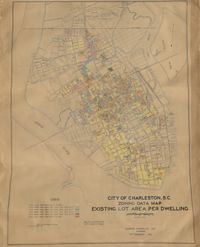
Hand-colored, linen map showing Charleston peninsula existing lot area per dwelling from Murray Boulevard to the northern limits of the city at Mount Pleasant Road. The maps shows lots less than 1,000 square feet; lots more than 1,000 square feet and less than 1,500 square feet; lots more than 1,500 square feet and less than 2,500 square feet; lots more than 2,500 square feet and less than 3,000 square feet; lots more than 3,000 square feet and less than 4,500 square feet; and lots greater than 4,500 square feet. Map measure 47" by 63".
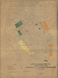
Hand-colored, linen map showing existing city properties including parks, playgrounds, port utilities, public buildings, fire stations, municipal service properties, and miscellaneous properties from Murray Boulevard to the northern limits of the city at Mount Pleasant Road. Map measures 42" by 60".
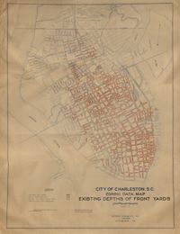
Hand-colored, linen map showing Charleston peninsula existing depths of front yards (5 feet and under, 6 to 14 feet, 15 to 24 feet, 25 feet and over). Map reflects Murray Boulevard to the northern limits of the city at Mount Pleasant Road. Map measures 47" by 63".
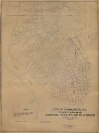
Hand-colored, linen map showing Charleston peninsula heights of buildings from Murray Boulevard to the northern limits of the city at Mount Pleasant Road. Height in stories is indicated by color coding. Map shows buildings of three stories or more. Map measures 42" by 60".
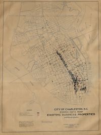
Hand-colored, linen map showing Charleston peninsula existing business properties, public garages, and gasoline service stations from Murray Boulevard to the northern limits of the city at Mount Pleasant Road. Map measures 46.75" by 63".
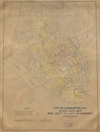
Hand-colored, linen map showing Charleston peninsula lot occupancy from Murray Boulevard to the northern limits of the city at Mount Pleasant Road. Map is color coded to show lot occupancy percentages on the peninsula. Map measures 46.5" x 63".
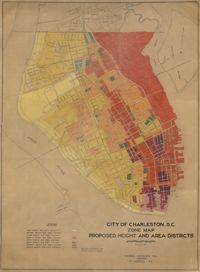
Hand-colored, linen map showing proposed height and area districts for the city of Charleston. Map shows eight height and area districts from Murray Boulevard to the northern limits of the city at Mount Pleasant Road. Map measures 42" by 60".
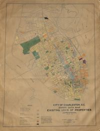
Hand-colored, linen map showing Charleston peninsula existing lot uses from Murray Boulevard to the northern limits of the city at Mount Pleasant Road. Map shows one, two, and multiple dwelling units, service stations, garages, industrial sites, and railroads. Information on map was compiled during field observations made from October through December 1930. Map measures 46.25" by 63."
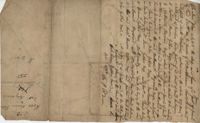
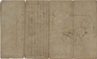
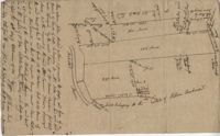
True copy of Peter Sinkler plat contains 310 acres in Craven County [now in parts of Berkeley, Charleston, Georgetown, and Williamsburg counties] bounding northwest on land of Isaac Porcher and Rene Pyre, southeast on land of Robert Taylor and Rene Ravenel, and northwest on Santee River. Names associated with this plat are Peter Sinkler, Robert Taylor, Ephraim Mitchell, Rene Pyre, Isaac Porcher, Rene Ravenel, John Brernon, and Henry Mowlon. Notable geographic locations include St. James Parish, the Santee River and Craven County.
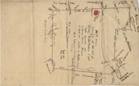
Copy of a plan of lots No.1-7, 9-11 on Cumberland Street in Charleston, Ward No.3. Indicates some buildings including a brick stable at No. 9 and DeBorr’s house and lot. “Lands of Mr. Edwards" is written above the lots. Names associated with this plat include De Borr, Edwards, and Charles Parker. Notable geographic locations include Church Street, Corr Alley or Philadelphia Street, Cumberland Street, and Ward Number 3.
Plat of 500 acres in Colleton County. Very little detail included. Names associated with this plat are Alexander French, Thomas Clifford, Bettison, Francis Young, George Hunter, and John Bartys.
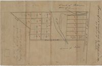
Farm of 54 across for sale by Rutherford, individual plots lettered A-S. Names associated with this plat are Birkman, Rutledge Phokes, Fitch, Kinsman and Rutherford. Notable geographic locations include Broad Street and Dorchester Road.
Plat of land which includes a marsh and creeks, very little other detail. Names associated with this plat are Purcell, Thomas Rose, John Blade, and E. Rivers. Notable geographic locations include Tiger Swamp.
82 Acre plat of land, shows some trees with minimal notation. Names associated with this plat are John Green and Anthony Mitchell. Notable geographic locations include Waccamaw Neck.
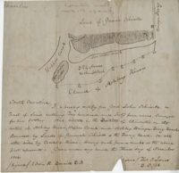
Plat of 237 acres belonging to Rob Reeves Gibbes. Detailed marsh and high land along with the location and outline of a house. Names associated with this plat are Robert Reeve Gibbes, Nathaniel Heyward, John Gibbes, Thomas Gibbes, and Lewis Gibbes. Notable geographic locations include the Combahee River, Tupelo Swamp, and Charleston District.
Office copy of a survey of 31 acres of land for Dr. R. H. Martin in Berkeley County. Notable geographic locations include Wappoo Road and Mill Tract. Names associated with this plat are R.H. Martin, G.G. DuPont, and W.B. Guerard.
876 acres of land west of Murray Road in St. John's Parish. Names associated with this plat are Chas Johnston, Ben Castell, William Simpson, Verth, and J.G. Wiare. Notable geographic locations include Wadboo Barony.
Plat of 500 acres belonging to George Mitchell in Colleton County near the Edisto River. Includes the outline of the property and the location of trees on the property line. Names associated with this plat are George Mitchell, Job Howe, and James Moore. Notable geographic locations include the Edisto River, Colleton County and St. Bartholomew's Parish.
Copy of a tract of 127 acres in the marsh on the Ashepoo River belonging to Sarah McPherson. Little detail included in the plat. Names associated with this plat are Sarah McPherson, Willliam Spense, and Joshua McPherson. Notable geographic locations are the Ashepoo River, Deer Creek, Ladson, and Colleton County.
Copy of a plan of 195 acres of land near the Cooper River including dams, a house, marsh and saw pit. Names associated with this plat include Mary Rupell, Robertson, Atkin, Dr. Brabangs, Withers, Jenson, Lanue and G. Arch.
1100 acres of land belonging to Thomas Woodward on the east and west side of Fish Pond Creek known as Ashepoo River. Names associated with this plat are Thomas Woodward, Elizabeth Woodward, James St. John, Billinger, and Blaky, and William. Notable geographic locations include Ashepoo River and Fish Pond Creek.
Office copy of a tract of land once belonging to Thomas Nau then John S. Cripps containing 277 1/2 acres. The land includes gum, white and red oak, and cedar trees along with posts, a rice field and a bridge over the public road from Rantoles [Rantowles] to Charleston. Names associated with this plat include John S. Cripps, Thomas Nau, and S. Lewis.
25 acres of land containing two dams, a reserve, and pine and oak trees owned by George Holmes near 7 mile south of lands owned by J. Meetze. Names associated with this plat include George Holmes, J. Meetze and Simons.
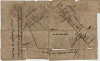
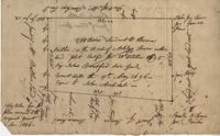
Copy of a plat of 355 Acres of land in Berkeley County near the West side of Cooper River, shows surrounding properties, doesn’t include land type or detailed notations. Names associated with this plat are Edward Keating, William Kimlough, Buvet, Matthew Beard, Colonel Chicken, Chapennoun Elliott, Robert Daniell, Longrove Thomas, Edward Keyting, Andrew Allens, William Gibbons, James Kenloch, William Adams, Allen Anderson, William Gibbons, Matthew Benson, Thomas Smith, John Vecandge [?], Francis Ternandol, and Allen Andrew. Notable geographic locations include St. James Parish, Goose Creek, Cooper River, and Berkeley County.
Plat of 19 acres in St. Andrew’s Parish. A corn field is noted as is a public road along with the neighboring property owners. Little other detail. Names associated with this plat are James C. Perry, Cook, Sault, Benjamin, F.R.N. [?] Smith, Dinzhals [?], S. Charles, and Cattell.
Small description of a 264 acre land, near Wappoo Creek, including land description. Names associated with this plat are John Schnerlie, Thomas S. Jones, and Edwin R. Dorrill. Notable geographic locations include the Ashley River, Wappoo Creek, Ashley Bridge Ferry Road, and Charleston District.
Lands of Paul Guerard called “The Hut," shows a public road and creeks, includes measurements. Names associated with this plat are Parker, W.B. Guerard, William Blacklock, Micah Jenkins, Thomas Humscoube, and Paul C. Grimball.
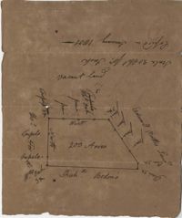
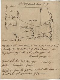
Copy of a plat of 200 acres in St. George’s Parish. The property lines and various trees located on them are the only details included. Names associated with this plat are G. Wagner, Samuel Jones, Thomas Hotkins, Francis Yonge, and Robert Daniell. Notable geographic locations include the Stono River and Berkeley County.
Copy of a plat of 200 acres on the neck of the Ashley River belonging to Thomas Butler. Only property outline and a few notes about the edges of the property are included. Names associated with this plat are Thomas Butler, Barker, John Bradford, and John Archdale. Notable geographic locations include the Ashley River, Clear Spring and St. Andrew's Parish.
Plat of approximately 300 acres of marsh and farm land on the Stono River. Marsh and high land are denoted on the plat with few other details. Names associated with this plat are Mansfield, Mathuvin [?] Guevin, Franics [?] Guevin, Rebecca Chapman, Francis Wilkinson, Gaspar Trotti, and Stephen Ravenel. Notable geographic locations are the Stono River.
Copy of a plat of 200 acres in St. George’s Parish. The property lines and various trees located on them are the only details included. Names associated with this plat are Benjamin Cattell, Richard Bedon, and Edward North. Notable geographic locations are St. George's Parish and Cypress.
Plat of land of 64 acres laid out for Allard Belin situated on Sandy Island. Names associated with this plat are Allard Berlin, John Hardwick and D.T. Waring.
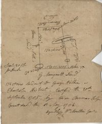
"Jonathan Burnbridge 310 acres certified for him the 24th day of December 1805. Pursuant to a warrant from Artemar B. Darby D. S. G. dated the 20th day of December 1805 having admeasured and laid out unto Jonathan Bunbridge a tract of land containing 310 acres situated in Charleston District bounded by a lain [sic] running NW and NW by land of Ralph Izard NE on land of William Stephens NE and E on land not known and by all other lines on land of Doctor William Stephens and hath such form and marks as the above plat represents Surveyed the 21 day of December 1805 Michael Byrne Dep Surveyor." Names associated with this plat are Jonathan Darby Bunbridge, B. Artemar, Ralph Izard, William Stepens, Dr. William Stephens, and Michael Byrne. Notable geographic locations include St. Bartholomew’s Parish.
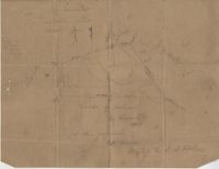
“Plan of parcel of land of late belonging to John Jones and now sold and conveyed by the said Jones to James Carsen for 850 acres but the request of the said Carsen. The said tract of land has been resurveyed and find it to contain but 805 acres of land or there about, so that the original survey must have taken in 45 acres of the marshes of Bohicket River...true copy taken from the original plat in the property of Mr. William Carsen in June 1794." Names associated with this plat are John Carsen, John Jones, James Carsen, William Chambers, James Young, Thomas Winborns, McDoul, Abigail Winborn, John Gibbs, Wilkins, and William Carsen. Notable geographic locations include St. John's Parish, Bohicket River, Wadmalaw River and Johns Island.
Sipros Openen Plantation, 342 acre plantation in Colleton county near Stono River, an island plantation, shows property lines and no land detail, also shows surrounding area outside of the plantation. Names associated with this plat are William Willersby, Alens [?], Thomas Lattson, Robert Murens, Ambers Helle, Charles Craven, Hells and Thomas Broughton. Notable geographic locations include Colleton County, Stono River, Sipros Opener, and Johns Island.
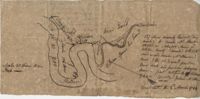
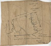
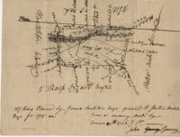
Plan of the land claimed by James Sinkler on Santee River and comprehended with the claim of White Oak Plantation belonging to Ralph Izard. Names associated with this plat are Ralph Izard, James Sinkler, Peter Sinkler, John Guerry, and Stephens.
Plan of 500 acres of land south of the Mile Swamp and near the May River. Names associated with this plat are J. Pears and Bellamy Crawford. Notable geographic locations are The Thickets, May River, The Mile Swamp and St. Luke's Parish.
Plat of land belonging to Bellamy Crawford possibly called the Thickets. Names associated with this plat are Bellamy Crawford. Notable geographic locations are May River, The Mile Swamp and St. Luke's Parish.
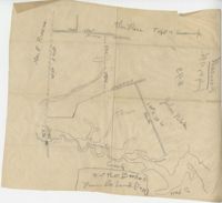
Plan of a tract of 1000 acres of land in Wall Eye Swamp in Craven County [now in parts of Berkeley, Charleston, Georgetown, and Williamsburg counties]. Names associated with this plat are Samuel Cooper, James Sinkler, Peter Sinkler, Isham Moore, John Bremar, and William Bull.
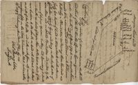
Copy of a plat of 250 acres laid out to Abraham Michau on the north side of Santee River and “now belonging to John Pedro." Names associated with this plat are Abraham Michau, John Pedro, George Hunter and James Glen. Notable geographic locations include the Santee River, Prince Frederick Parish and Georgetown District.
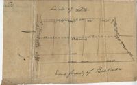
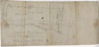
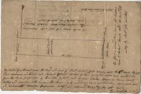
Plat of 53 acres off of Dorchester Road which is divided into lots. Very little details or information. Names associated with this plat are Fitch and Beckman. Notable geographic locations include Dorchester Road.
Plat of 500 acres in Craven County on the Pee Dee River annexed to the original 40,000 acres orginally granted to Landgrave Robert Daniel. Names associated with this plat are Robert Daniel, Robert Gibbs, the Lords Proprietors, Thomas Broughton and Waring. Notable geographic locations include the Pee Dee River, Craven County [now in parts of Berkeley, Charleston, Georgetown, and Williamsburg counties], Sawhee, Beedee, and Georgetown District.
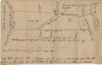
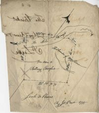
1432 acres of land given to Villeconteux; shows mill creek and Raccoon Pond, one area is colored in red labeled "Gardenes Old Field." Names associated with this plat are Barry Villeconteux, Rich Selby, N. Windham, Rhames, Ben Villeponteaux, Lowe Leviman, W.W. Villeponteaux, J.C. Brinson, Addison, Gaillard, Homes, and Thomas Ashley. Notable geographic locations include St. John's Parish, Raccoon Pond, Mill Creek, School House Branch, Blind Doe Run, and Edge Poing.
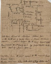
Copy of a plat laid out at Goose Creek now belonging to Benjamin Mazyck. 200 acres of land commonly called Busharia. Butting and bounding on the north and west on Col. James Moore land and the south on Captain Schrenckingh and on the east on Madam Davis' land. Names associated with this plat are Benjamin Mazyck, Davis, Lawson, Thomas Smith, Benjamin Schrenckingh, James Moore, and David Daw. Notable geographic locations include Busharia, Booshee, and Goose Creek.