Plat in St. Bartholomew's Parish 1796
Close Viewer
- Title:
- Plat in St. Bartholomew's Parish 1796
- Date:
- 1796
- Description:
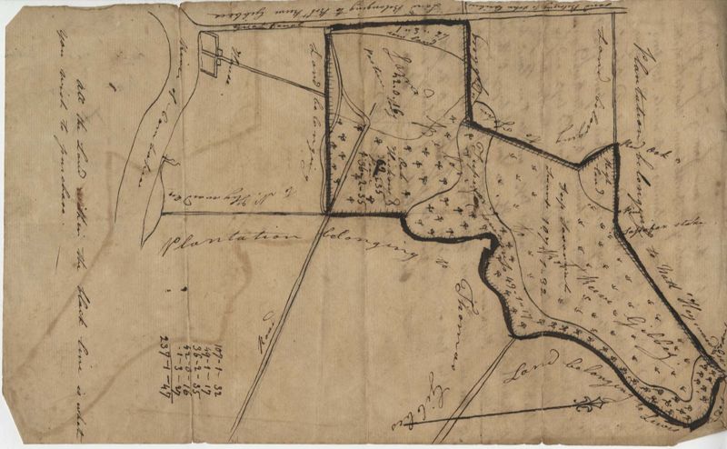
- Plat of 237 acres belonging to Rob Reeves Gibbes. Detailed marsh and high land along with the location and outline of a house. Names associated with this plat are Robert Reeve Gibbes, Nathaniel Heyward, John Gibbes, Thomas Gibbes, and Lewis Gibbes. Notable geographic locations include the Combahee River, Tupelo Swamp, and Charleston District.
- Collection Title:
- John McCrady Plats and Deeds Collection
- Contributing Institution:
- South Carolina Historical Society
- Media Type:
- Maps
- Topical Subject:
- Conveyancing--South Carolina, Maps, and Surveying--South Carolina
- Geographic Subject:
- Combahee River (S.C.) and Charleston District (S.C.)
- S.C. County:
- Charleston County (S.C.) and Colleton County (S.C.)
- Language:
- English
- Shelving Locator:
- 510.00, Box 1, Folder 29
- Date Digital:
- 2016-02-08
- Digitization Specifications:
- 400 dpi, 24-bit depth, color, Bookeye 4 Basic, Archival masters are tiffs.
- Internet Media Type:
- image/jpeg
- Copyright Status Statement:
- Public Domain.
- Access Information:
- For more information and re-use requirements contact the South Carolina Historical Society, Charleston, SC, 29401.
- Admin ID:
- 223188
Permalink