Charleston District Plat 1805
Close Viewer
- Title:
- Charleston District Plat 1805
- Date:
- 1805
- Description:
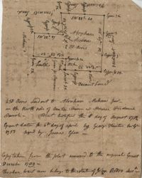
- "Jonathan Burnbridge 310 acres certified for him the 24th day of December 1805. Pursuant to a warrant from Artemar B. Darby D. S. G. dated the 20th day of December 1805 having admeasured and laid out unto Jonathan Bunbridge a tract of land containing 310 acres situated in Charleston District bounded by a lain [sic] running NW and NW by land of Ralph Izard NE on land of William Stephens NE and E on land not known and by all other lines on land of Doctor William Stephens and hath such form and marks as the above plat represents Surveyed the 21 day of December 1805 Michael Byrne Dep Surveyor." Names associated with this plat are Jonathan Darby Bunbridge, B. Artemar, Ralph Izard, William Stepens, Dr. William Stephens, and Michael Byrne. Notable geographic locations include St. Bartholomew’s Parish.
- Collection Title:
- John McCrady Plats and Deeds Collection
- Contributing Institution:
- South Carolina Historical Society
- Media Type:
- Maps
- Personal or Corporate Subject:
- Izard family
- Topical Subject:
- Conveyancing--South Carolina, Maps, and Surveying--South Carolina
- Geographic Subject:
- Charleston District (S.C.)
- Language:
- English
- Shelving Locator:
- 510.00, Box 2, Folder 1
- Date Digital:
- 2016-02-22
- Digitization Specifications:
- 400 dpi, 24-bit depth, color, Bookeye 4 Basic, Archival masters are tiffs.
- Internet Media Type:
- image/jpeg
- Copyright Status Statement:
- Public Domain.
- Access Information:
- For more information and re-use requirements contact the South Carolina Historical Society, Charleston, SC, 29401.
- Admin ID:
- 223225
Permalink