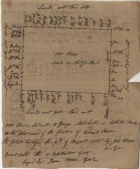
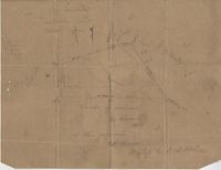
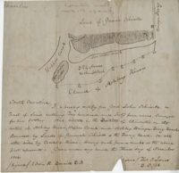
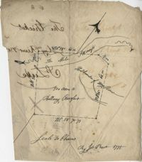
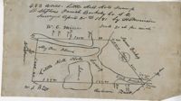
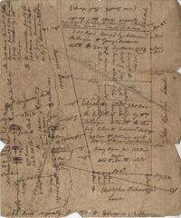
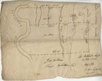
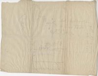
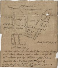
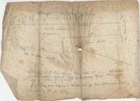
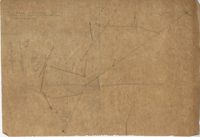
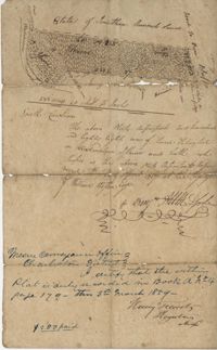
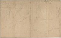
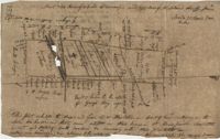
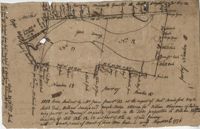
True copy of Peter Sinkler plat contains 310 acres in Craven County [now in parts of Berkeley, Charleston, Georgetown, and Williamsburg counties] bounding northwest on land of Isaac Porcher and Rene Pyre, southeast on land of Robert Taylor and Rene Ravenel, and northwest on Santee River. Names associated with this plat are Peter Sinkler, Robert Taylor, Ephraim Mitchell, Rene Pyre, Isaac Porcher, Rene Ravenel, John Brernon, and Henry Mowlon. Notable geographic locations include St. James Parish, the Santee River and Craven County.
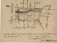
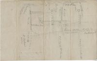
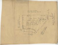
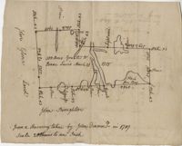
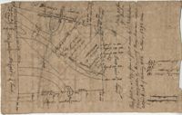
Copy of a plan of lots No.1-7, 9-11 on Cumberland Street in Charleston, Ward No.3. Indicates some buildings including a brick stable at No. 9 and DeBorr’s house and lot. “Lands of Mr. Edwards" is written above the lots. Names associated with this plat include De Borr, Edwards, and Charles Parker. Notable geographic locations include Church Street, Corr Alley or Philadelphia Street, Cumberland Street, and Ward Number 3.
Plat of 500 acres in Colleton County. Very little detail included. Names associated with this plat are Alexander French, Thomas Clifford, Bettison, Francis Young, George Hunter, and John Bartys.
Farm of 54 across for sale by Rutherford, individual plots lettered A-S. Names associated with this plat are Birkman, Rutledge Phokes, Fitch, Kinsman and Rutherford. Notable geographic locations include Broad Street and Dorchester Road.
Plat of land which includes a marsh and creeks, very little other detail. Names associated with this plat are Purcell, Thomas Rose, John Blade, and E. Rivers. Notable geographic locations include Tiger Swamp.
82 Acre plat of land, shows some trees with minimal notation. Names associated with this plat are John Green and Anthony Mitchell. Notable geographic locations include Waccamaw Neck.
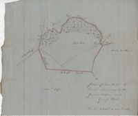
Plat of 237 acres belonging to Rob Reeves Gibbes. Detailed marsh and high land along with the location and outline of a house. Names associated with this plat are Robert Reeve Gibbes, Nathaniel Heyward, John Gibbes, Thomas Gibbes, and Lewis Gibbes. Notable geographic locations include the Combahee River, Tupelo Swamp, and Charleston District.
Office copy of a survey of 31 acres of land for Dr. R. H. Martin in Berkeley County. Notable geographic locations include Wappoo Road and Mill Tract. Names associated with this plat are R.H. Martin, G.G. DuPont, and W.B. Guerard.
876 acres of land west of Murray Road in St. John's Parish. Names associated with this plat are Chas Johnston, Ben Castell, William Simpson, Verth, and J.G. Wiare. Notable geographic locations include Wadboo Barony.
Plat of 500 acres belonging to George Mitchell in Colleton County near the Edisto River. Includes the outline of the property and the location of trees on the property line. Names associated with this plat are George Mitchell, Job Howe, and James Moore. Notable geographic locations include the Edisto River, Colleton County and St. Bartholomew's Parish.
Copy of a tract of 127 acres in the marsh on the Ashepoo River belonging to Sarah McPherson. Little detail included in the plat. Names associated with this plat are Sarah McPherson, Willliam Spense, and Joshua McPherson. Notable geographic locations are the Ashepoo River, Deer Creek, Ladson, and Colleton County.
Copy of a plan of 195 acres of land near the Cooper River including dams, a house, marsh and saw pit. Names associated with this plat include Mary Rupell, Robertson, Atkin, Dr. Brabangs, Withers, Jenson, Lanue and G. Arch.
1100 acres of land belonging to Thomas Woodward on the east and west side of Fish Pond Creek known as Ashepoo River. Names associated with this plat are Thomas Woodward, Elizabeth Woodward, James St. John, Billinger, and Blaky, and William. Notable geographic locations include Ashepoo River and Fish Pond Creek.
Office copy of a tract of land once belonging to Thomas Nau then John S. Cripps containing 277 1/2 acres. The land includes gum, white and red oak, and cedar trees along with posts, a rice field and a bridge over the public road from Rantoles [Rantowles] to Charleston. Names associated with this plat include John S. Cripps, Thomas Nau, and S. Lewis.
25 acres of land containing two dams, a reserve, and pine and oak trees owned by George Holmes near 7 mile south of lands owned by J. Meetze. Names associated with this plat include George Holmes, J. Meetze and Simons.
Copy of a plat of 355 Acres of land in Berkeley County near the West side of Cooper River, shows surrounding properties, doesn’t include land type or detailed notations. Names associated with this plat are Edward Keating, William Kimlough, Buvet, Matthew Beard, Colonel Chicken, Chapennoun Elliott, Robert Daniell, Longrove Thomas, Edward Keyting, Andrew Allens, William Gibbons, James Kenloch, William Adams, Allen Anderson, William Gibbons, Matthew Benson, Thomas Smith, John Vecandge [?], Francis Ternandol, and Allen Andrew. Notable geographic locations include St. James Parish, Goose Creek, Cooper River, and Berkeley County.
Plat of 19 acres in St. Andrew’s Parish. A corn field is noted as is a public road along with the neighboring property owners. Little other detail. Names associated with this plat are James C. Perry, Cook, Sault, Benjamin, F.R.N. [?] Smith, Dinzhals [?], S. Charles, and Cattell.
Small description of a 264 acre land, near Wappoo Creek, including land description. Names associated with this plat are John Schnerlie, Thomas S. Jones, and Edwin R. Dorrill. Notable geographic locations include the Ashley River, Wappoo Creek, Ashley Bridge Ferry Road, and Charleston District.
Lands of Paul Guerard called “The Hut," shows a public road and creeks, includes measurements. Names associated with this plat are Parker, W.B. Guerard, William Blacklock, Micah Jenkins, Thomas Humscoube, and Paul C. Grimball.
Copy of a plat of 200 acres in St. George’s Parish. The property lines and various trees located on them are the only details included. Names associated with this plat are G. Wagner, Samuel Jones, Thomas Hotkins, Francis Yonge, and Robert Daniell. Notable geographic locations include the Stono River and Berkeley County.
Copy of a plat of 200 acres on the neck of the Ashley River belonging to Thomas Butler. Only property outline and a few notes about the edges of the property are included. Names associated with this plat are Thomas Butler, Barker, John Bradford, and John Archdale. Notable geographic locations include the Ashley River, Clear Spring and St. Andrew's Parish.
Plat of approximately 300 acres of marsh and farm land on the Stono River. Marsh and high land are denoted on the plat with few other details. Names associated with this plat are Mansfield, Mathuvin [?] Guevin, Franics [?] Guevin, Rebecca Chapman, Francis Wilkinson, Gaspar Trotti, and Stephen Ravenel. Notable geographic locations are the Stono River.
Copy of a plat of 200 acres in St. George’s Parish. The property lines and various trees located on them are the only details included. Names associated with this plat are Benjamin Cattell, Richard Bedon, and Edward North. Notable geographic locations are St. George's Parish and Cypress.
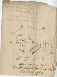
Plat of land of 64 acres laid out for Allard Belin situated on Sandy Island. Names associated with this plat are Allard Berlin, John Hardwick and D.T. Waring.
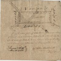
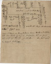
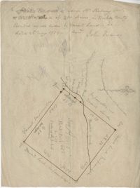
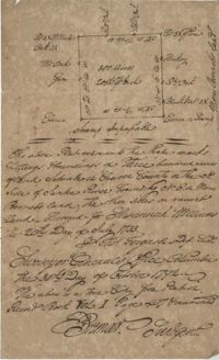
"Jonathan Burnbridge 310 acres certified for him the 24th day of December 1805. Pursuant to a warrant from Artemar B. Darby D. S. G. dated the 20th day of December 1805 having admeasured and laid out unto Jonathan Bunbridge a tract of land containing 310 acres situated in Charleston District bounded by a lain [sic] running NW and NW by land of Ralph Izard NE on land of William Stephens NE and E on land not known and by all other lines on land of Doctor William Stephens and hath such form and marks as the above plat represents Surveyed the 21 day of December 1805 Michael Byrne Dep Surveyor." Names associated with this plat are Jonathan Darby Bunbridge, B. Artemar, Ralph Izard, William Stepens, Dr. William Stephens, and Michael Byrne. Notable geographic locations include St. Bartholomew’s Parish.
“Plan of parcel of land of late belonging to John Jones and now sold and conveyed by the said Jones to James Carsen for 850 acres but the request of the said Carsen. The said tract of land has been resurveyed and find it to contain but 805 acres of land or there about, so that the original survey must have taken in 45 acres of the marshes of Bohicket River...true copy taken from the original plat in the property of Mr. William Carsen in June 1794." Names associated with this plat are John Carsen, John Jones, James Carsen, William Chambers, James Young, Thomas Winborns, McDoul, Abigail Winborn, John Gibbs, Wilkins, and William Carsen. Notable geographic locations include St. John's Parish, Bohicket River, Wadmalaw River and Johns Island.
Sipros Openen Plantation, 342 acre plantation in Colleton county near Stono River, an island plantation, shows property lines and no land detail, also shows surrounding area outside of the plantation. Names associated with this plat are William Willersby, Alens [?], Thomas Lattson, Robert Murens, Ambers Helle, Charles Craven, Hells and Thomas Broughton. Notable geographic locations include Colleton County, Stono River, Sipros Opener, and Johns Island.
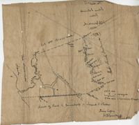
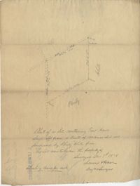
Plan of the land claimed by James Sinkler on Santee River and comprehended with the claim of White Oak Plantation belonging to Ralph Izard. Names associated with this plat are Ralph Izard, James Sinkler, Peter Sinkler, John Guerry, and Stephens.
Plan of 500 acres of land south of the Mile Swamp and near the May River. Names associated with this plat are J. Pears and Bellamy Crawford. Notable geographic locations are The Thickets, May River, The Mile Swamp and St. Luke's Parish.
Plat of land belonging to Bellamy Crawford possibly called the Thickets. Names associated with this plat are Bellamy Crawford. Notable geographic locations are May River, The Mile Swamp and St. Luke's Parish.
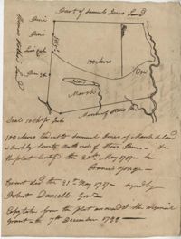
Plan of a tract of 1000 acres of land in Wall Eye Swamp in Craven County [now in parts of Berkeley, Charleston, Georgetown, and Williamsburg counties]. Names associated with this plat are Samuel Cooper, James Sinkler, Peter Sinkler, Isham Moore, John Bremar, and William Bull.
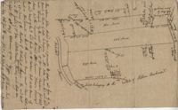
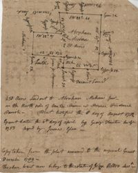
Copy of a plat of 250 acres laid out to Abraham Michau on the north side of Santee River and “now belonging to John Pedro." Names associated with this plat are Abraham Michau, John Pedro, George Hunter and James Glen. Notable geographic locations include the Santee River, Prince Frederick Parish and Georgetown District.
Plat of 53 acres off of Dorchester Road which is divided into lots. Very little details or information. Names associated with this plat are Fitch and Beckman. Notable geographic locations include Dorchester Road.
Plat of 500 acres in Craven County on the Pee Dee River annexed to the original 40,000 acres orginally granted to Landgrave Robert Daniel. Names associated with this plat are Robert Daniel, Robert Gibbs, the Lords Proprietors, Thomas Broughton and Waring. Notable geographic locations include the Pee Dee River, Craven County [now in parts of Berkeley, Charleston, Georgetown, and Williamsburg counties], Sawhee, Beedee, and Georgetown District.
1432 acres of land given to Villeconteux; shows mill creek and Raccoon Pond, one area is colored in red labeled "Gardenes Old Field." Names associated with this plat are Barry Villeconteux, Rich Selby, N. Windham, Rhames, Ben Villeponteaux, Lowe Leviman, W.W. Villeponteaux, J.C. Brinson, Addison, Gaillard, Homes, and Thomas Ashley. Notable geographic locations include St. John's Parish, Raccoon Pond, Mill Creek, School House Branch, Blind Doe Run, and Edge Poing.
Copy of a plat laid out at Goose Creek now belonging to Benjamin Mazyck. 200 acres of land commonly called Busharia. Butting and bounding on the north and west on Col. James Moore land and the south on Captain Schrenckingh and on the east on Madam Davis' land. Names associated with this plat are Benjamin Mazyck, Davis, Lawson, Thomas Smith, Benjamin Schrenckingh, James Moore, and David Daw. Notable geographic locations include Busharia, Booshee, and Goose Creek.
Plat of 89 acres in the Beaufort District. Plat shows the location of several ponds. Little other detail is included. Names associated with this plat are N.H. Johnson, R.J. Marker, Mary Kittles, John H. Raddell [?], and Brown. Notable geographic locations include the Savannah River, Beaufort District and Dry Gull Branch.
Plat of 220 acres on the Black River belonging to John Luck. Details include the areas of the river and marsh, and the location of trees on the property lines. Names associated with this plat are John Luch and John Hardwick. Notable geographic locations include Black River and Craven County Craven County [now in parts of Berkeley, Charleston, Georgetown, and Williamsburg counties].
483 acre plot of Little Hell Hole Swamp, includes islands and surrounding property owners doesn't include land detail. Names associated with this plat are H.S. Morrison, Isaac Bishop, W.C. Miller, W.J. Ball, and Anderson. Notable geographic locations include St. Stephens Parish, Hog Pen Island, Little Hell Hole Swamp, and Berkeley County.
Plat of 250 acres on Wadmalaw Creek. Includes short explanation, but plat itself includes very little details. Names associated with this plat are Hugh McDowel, James McDowel, James Carson, Dalziel Hunter, James Young and Ellis.
Plat of a land containing ten acres, minimal detail showing the surrounding property owners and two roads; Dills Bluff and unnamed public road. Names associated with this plat are Plenty White, Simons and Howe. Notable geographic locations include Dill's Bluff.
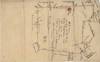
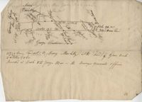
Sketch of property including roads and fields, some specific house names like Rectory house and W. Dotolhinese's house. Names associated with this plat are Glisbe, Priohau, Dotolhinese and Glebe. Notable geographic locations include St. Johns Parish, Broad Road, Wadboo [?] Bridge, Road to Pontauxs, and Road to Cordyville [?].
Plan of a body of land now part belonging to Mr. George Summers and part to John Summers and part of the estate of Brigdon Smith lying at Stono adjoining lands of S. Matlock. Names associated with this plat are John Summer, George Summer, Brigdon Smith, Malleck, J. Fenwich, Edward Bellinger, Christopher Wilkenson, John Tucker, W. Owen, Henry Hyrne, Inch, Downs, Elizabeth Elliott, George Tommer, Thomas Farr, Smith Mellichamp, and Ann Downs. Notable geographic locations include New Road, St. Paul's Parish and Stono.
200 acres laid out to Jonathan Stocks situated in Colleton County lying on the side of Kywa [Kiawah] Creek, shows surrounding properties with no land type or detail. Names associated with this plat are Jonathan Stock, John Jones, John Edenborough, Thomas Jones, and Thomas Weatherby.
340 acres of land laid out to George Mitchell on the east side of a branch of Ashepoo River called the Horseshoe Creek. Names associated with this plat are George Mitchell, James St. John, Thomas Broughton and John Andrews. Notable geographic locations include the Ashepoo River and Horseshoe Creek.
Plat includes 624 acres surveyed for Gideon DuPont. Plat does not contain structures. Names associated with this plat are Gideon DuPont, William Thomas Elliot, Captain Daniel Godin, and Middleton. Notable geographic locations are St. Bartholomew's Parish, the Ashepoo River and Deer Creek.
Plat of 500 acres granted to Robert Cahousac January 10,1771. Names associated with this plat are Robert Cahousac, Samuel Cooper, Gabriel Gigneliat [?], Mitchum, Witten, Zachariah Villeponteux, William Mazyck, Juxbury Lumber Co, William Washington, and Charles Parker. Notable geographic locations include St. Bartholomew's Parish and Charleston County.
200 acres laid out to Joan Gryce, on the northwest side of Keywaw [Kiawah] Creek in Colleton County, on the left side it is bordered by the Marshes of Bohicket Creek. Names associated with this plat are Joan Gryce and James Witter. Notable geographic locations include Johns Island, Keywaw [Kiawah] Creek, and Bohicket Creek.
Plat contains 211 acres copied from a release form annexed to Nathaniel Broughton to Alexander Broughton. Part of Mulberry Tract. Names associated with this plat are William John Broughton, Nathaniel Broughton, Alexander Broughton and A. Domini. Notable geographic locations include Doken Creek, The Farm, St. John's Parish and Long Branch Creek.
Plat of 300 acres in Berkeley County. Very little detail included in the plat. Names associated with this plat are James McKelvey, John Evans and Sarah Vance. Notable geographic locations include Berkeley County and Russells Creek.
Plan of a tract of land belonging to George Chisolm. Names associated with this plat are George Chisolm, John Scott, A. Andrew, Thomas Hollingsby [?], and Thomas. Notable geographic locations include the Ashley River and Kuskawah [Kushiwah] Creek.
Plat of 1126 acres in St. James Goose Creek on Wasamasaw [Wassamassaw] Swamp. Plat is in pencil and is difficult to read the few details, although there are a few outlines of buildings included, but difficult to tell what they are. Names associated with this plat include Daniel Gelyer, J. Ferrels, Thomas Cusack [?], and James Haney. Notable geographic locations include Wasamasaw [Wassamassaw] Swamp, Sheep Island, Goose Creek, Road to Dorchester, and Ekells Branch.
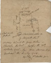
319 acre plot of land situated on Ocean Bay in St. James Parish, part of the "Hodge Grant," shows some land details like creeks and cypress ponds. Names associated with this plat are T. Hataway, Hodge, W.B. Guerard, Benjamin Fort, B.P. Colburn, Hiram Hodge , R.J. Morrison and W.H. Mellard. Notable geographic locations include Ocean Bay, St. James Parish and Santee.
Plat of land along the Combahee River containing 5567 acres laid out for Daniel Doiley. Names associated with this plat are Daniel Doiley, Smith, Gordon Garrett, and Philips. Notable geographic locations include the Combahee River, Prince William's Parish and Farr Bluff.
General Cutherbert's land on Big Pipe Creek. Names associated with this plat are General Cuthbert, B.H. Roberts, Ball, Peters and David DeSapah [?]. Notable geographic locations include the Savannah River.
Plan of lands at Bee Creek belonging to Mr. James Bolen called Gray's Hill. Names associated with this plat include James Bolen. Notable geographic locations include St. Lukes Parish, Gray's Hill, Grey's Hill Landing, Bees Creek, and Purrysburgh.
Plat consists of 100 3/4 acres. Names associated with this plat include William Walter, William Kittlebum, Coachman, Thomas Hamilton, Benjamin, Richard and Allen. Notable geographic locations include St. George Parish and Cypress.
Plat consists of 900 acres. Names associated with this plat include Rero A. Stoble, James Bullock and H. Bryan. Notable geographic locations include Savannah and St. Peter's Parish.
300 acres of land belonging to Richard Downes at Stono. Names associated with this plat include Richard Downes, Edmond Bellinger, Thomas Mellichamp, Christopher Welkin and Archibald Stanyarn.
83 acre parcel of land that shows the land belonging to the estate of William Williamson, shows rice fields, swamp in woods, public drains, and roads. Names associated with this plat are William Williamson, George Haigery, and James Parsons. Notable geographic locations include the Stono River and Wenners.
Plat of 419 acres near Goose Creek sold to Benjamin Wood by John Parker. Only the trees located on the property line and names on neighboring property owners are included. Names associated with this plat are John Parker, Benjamin Wood, Thomas Barker, John Barley, James Boswood, Benjamin Woods, John Stevens, Thomas Hodson, I. Drayton, Thomas Mell, and Ben Godin.
Copy of a plat of 500 acres originally laid out to John Smith, now (1805) belonging to Alexander Bower as nephew and heir to the grantee. Details include swamps, surrounding lands, and trees. Names associated with this plat are Alexander Bower, John Smith, F. Bremar, William Moultrie, Sarah Blakeway, William Cattle, and Henry Crum.
960 acres of land situated lying and being in Colleton County, butting and bounding to the north on part of John Seabrook's land to the east on Ashepoo River to the South on land of Captain Thomas Flemming and part of John Dears’ Land. Names associated with this plat are Benjamin Whitaker, Thomas Pinckney, Captain Thomas Flemming, John Seabrook, John Dear, Richard Woodward, John Hutchinson, John Godfrey, Samuel Larrington, James St. John, Godfrey, Elizabeth Woodward, William McPherson, Thomas M. Pinckney, and James M. Pinckney. Notable geographic locations are Ashepoo River, Dear's Creek and Colleton County.
Copy of plat granted to John Atchison. "The plat annexed to the grant dated March 2, 1736." Names associated with this plat are John Atchison, James St. John, Thomas Broughton, J. Branch and Middleton. Notable geographic locations include Santee, Four Mile Creek, Santee River, and Cravens County [now in parts of Berkeley, Charleston, Georgetown, and Williamsburg counties].
77 acres of marsh in two pieces situated on Johns Island along Stono River. Names associated with this plat are J.N. Mainville, Thomas Simmons, James Nicholas, Guervin, William Simmons and Marshall. Notable geographic locations are the Stono River, Johns Island, Charleston District, and Marshalls Creek.
Copy of Plat of 157 acres of land laid out to Harrison on Wadmalaw Island at the head of Wadmalaw River. Names associated with this plat are Christopher Harrison, Henry Walkins, and Luna Williams.
Plat of land laid out to Huggins of 58 acres situated on the NE side of Pee Dee River butting and bounding to the North on William Alston's land and to the south and southwest on unknown land. Names associated with this plat are Huggins, William Alston, Job Roshmahler and John Hardwick.
Plat includes 500 acres on the Cypress Swamp. Names associated with this plat are James Sanders, Matthew Nelson, William Abraham, Abraham Sanders, and Samuel Sanders. Notable geographic locations include St George’s Parish, Cypress Swamp, Dorchester, and Thorntree Swamp.
A quarter of an acre including a church on Marsh Field Plantation. Names associated with this plat are Thully T.G. Beneyor, Frederick Smith, J.G. Sturly, Rebecca Bennett and Rantowle. Notable geographic locations include St. Andrews Parish, Marsh Field Plantation, and Road to Rantowle's Ranch.
"This tract was conveyed by G. Anson Esquire thro his attorney, and Richard Lambton to Thomas Rivers February 15th 1775 and from said J. Rivers to Benj. Guerad Esquire October 7th 1779." 371 Acres laid out by William James January 21th 1774 by the request of William George Roupell attorney for Georg Anson Esquire Being part of a barony originally granted to Robert Wright [illegible] Esquire by the Lords Proprietors. [illegible] now by Ansons Barony and being part of Lot N 11 of said Barony situated near May River." Plat contains identification of a path and waterways but no structural information. Names associated with this plat include G. Anson, Richard Lambton, Thomas Rivers, Benjamin Guerad, George Roupell, Robert Wright, the Lords Proprietors and Hodgson. Notable geographic locations include St. Lukes Parish, May River and Anson's Barony.
Two small plats of land. One containing 200 acres of land laid out to Margaret Childs situated near the head of Weetee Branch. Bounding on the NE, NW, and SE, and West on vacant lands. Southwestardly on land formerly laid out to Daniel Gibbons. The second plat is 78 acres of land laid out to Robert Newman in Craven County bounding to the north of Orochone [?] and on all other sides by vacant land. Names associated with this plat are Daniel Gibbons, Robert Newman, James St. John, Thomas Broughton, and Margaret Childs. Notable geographic locations include Prince Frederick’s Parish, Georgetown district, Weetee River, and Christal [Crystal?] Spring.
Copy of two plats: 1) 300 acres conveyed by Thomas Lynch to William Moultrie April 1, 1762, afterwards conveyed by Moultrie to Benjamin Singleton 2) 53 acres conveyed by Francis Kinloch to William Moultrie on the 8th February, 1765 now belonging to Benjamin Singleton. Names associated with this plat are Thomas Lynch, William Moultrie, Benjamin Singleton, Francis Kinloch, and Manigault. Notable geographic locations include Santee, White Oak, Six Mile Creek, and the Santee River.
Plat of 288 acres of land situated on Wadmalaw Island. Names associated with this plat are William Weston, Jonathan Runnel, James Clarks, Benjamin Allston [?], and Henry Treads. Notable geographic locations include Wadmalaw River, Wadmalaw Island, Bain Bluff, and Charleston District.
"Copy of a plat of a tract now belonging to Richard Goughlr." The tract contains 500 acres and states that it was granted to Isaac Lewis on March 21, 1715. Names associated with this plat are Isaac Lewis, John Broughton, John Glover, John Diamond, and Richard Goughlr [?]. Notable geographic locations include Goose Creek, St. James Parish and Black Jon Bay.
Plan of approximately 1500 acres on Black River near Georgetown part now belonging to Kinloch and Gadsden. Names associated with this plat are Gadsden, Kinloch, Alston, Thomas Gadsden, James Lloyd, and Morreau [?] Sarrazin.
Copy of a plat annexed to the original grant for 1153 acres of land to Thomas Farr lettered A-E. Names associated with this plat are Daniel Green, Thomas Farr, Elizabeth Gibbs, Christopher Wilkinson, Joseph Smith, Andrew Smith, Thomas Smith, George Haig, Joseph Farr, Humphrey Sommers, and Benjamin Stoney.
156 acres laid out to John Bayly and granted to the said John Bayly in 1698 in Colleton County. Names associated with this plat are George Mitchell, John Bayly, and John Andrews.
100 square plot sold by Beauford, Boggy Gully runs through the southwest corner of the property. Names associated with this plat are William Byrd Beauford and J.B. Johnson.
Plat of 230 acres on Johns Island. Little detail included on the plat, but there is an short explanation of the deed. Names associated with this plat are John Jones, Ebenezer Simmons, James Witter, Samuel Palmevine, John Palmavin, and Welkins. Notable geographic locations included in this plat are the Keiwaugh [Kiawah] River, Coll’s Creek, Savannah Tract, Johns Island, and Colleton County.
Plan of a parcel of land situated on Johns Island and containing 86 1/2 acres. Being part of a body of land belonging to Thomas Mathews. Bounded northwardly by a public road, eastwardly on James Legare's land, and southwardly on land belonging to Isaac Holmes and Thomas Legare. Intended to be conveyed to Isaac Holmes. Names associated with this plat are Thomas Mathews, Isaac Holmes, Thomas Legare, William Stanyarn, Matthews and James Legare.
Two plats of lands along the Savannah River belonging to Stobo and Bullock. Names associated with this plat are Archibald Stobo, James Stobo, James Bullock, W. Hugh Bryan, Clawton [?], Cranford, J. Southerland, and Patrick Mikas. Notable geographic locations include the Savannah River, St. Peter's Parish and Purrysburgh Township.
222 acres sold by Archibald Stanyarn to Andrew Down in 1772. Reverse side includes notes on various conveyances. Names associated with this plat are Archibald Stanyarn, Andrew Down, J. Williamson, Edmond Bellizer, Thomas Cliffon, Kewn [?], David Joomer [?] and Henry. Notable geographic locations include Colleton County and Stono River.
Copy of a plat part now belonging to Benjamin Perry and part to John Pringle on the west side of Ashley River. Names associated with this plat include John Pringle, Benjamin Perry, John Julius Pringle, Lambert Lance, Abraham Ladson, Sarah Rose, Nathaniel Bradwell, Ephraim Mitchell, Thomas Drayton, John Frazer, Frances Baker, Thomas Osborn, Isaac Landson, Isaac Perry, John Drayton, Glen Drayton, Francis Ladson and W. John Cattle. Notable geographic locations include the Ashley River, Charleston, Berkeley County, and Ashley River Road.
Plat and abstracts of deeds belonging to James Laurence. Names associated with this plat include James Laurence, John Heyward, John Cole, Hogg, Loalan, Samuel Forsythe, William Forsythe, J. Schreiber, Henry Laurence, Harrison, Alexander Wright, Horry [?], and John Delayay.
Copy of plan of a plantation on Stono Swamp commonly called Stono Plantation belonging to Thomas Ferguson. Contains 630 acres. Approximately 360 acres is swamp and approximately 270 acres is highland. Names associated with this plat are Thomas Ferguson, George Haig, Joseph Farr, Mary Williams, Smith and John McSweeney. Notable geographic locations include Stono Swamp, Stono Plantation and Charleston.
650 acres belonging to Thomas Cordes on eastwest side of Fishpond Creek/ Ashepoo River bounding northwest on Elizabeth Woodward and south by Captain John Gibbes. Names associated with this plat are Thomas Cordes, Elizabeth Woodward, Captain John Gibbes, and Robert Johnson. Notable geographic locations include Fishpond Creek, the Ashepoo River and St. Bartholomew's Parish.
600 acres plot granted to Richard Floyd residing in Colleton County lying and budding on the southside of Bohickett Creek, shows surrounding property names and creeks, shows land notes but no land type or details. Also shown is 200 acres granted by the Lords Proprietors by William Arnell in Colleton County. Names associated with this plat are Richard Floyd, Graeme [?], the Lords Proprietors, Michael Ranell, Thomas Broughton, Robert Gibbes, William Atnel, Timothy Bellemey, Anthony Matthews, Ambross Hill, John Prescot and Neufville. Notable geographic locations include John's Island, Bohickett Creek, Colleton County, Ambrose Hill, Stono River, and Keywa [Kiawah] Island.
Plat of 130 acres on the Pee Dee River. Explains the plat and the surrounding area, drawing itself has little detail. Names associated with this plat are William Swinton, Joseph LaBruce, John White, James St. John, Elias Hopkin, and Thomas [?]. Notable geographic locations include the Pee Dee River, Black River, Weehaw Plantation, Kensington Plantation, Weehaw Creek, Georgetown, and Craven County [now in parts of Berkeley, Charleston, Georgetown, and Williamsburg counties].
Plat of 210 acres belonging to William Williams surrounded by land owned by Thomas Pinckney, Christopher Smith, and Thomas Dalton. No other notes written as to the location of the land. Very little detail on the plat included. Names associated with this plat include William Williams, Thomas Pinckney, Christopher Smith, Thomas Daulton, Thomas Smith, Edward Weekly, William Dry, Ralph Izard, Charles Fields, John Jolhimns [?], Thomas Broughton, and Hannah English aka Hannah Williams.
Plan of a tract of land containing 130 acres situated in Darres [Parris] Island in Beaufort. Names associated with this plat are Andrew Fitzsimons. Notable geographic locations include Beaufort, Darres [Parris] Island, and Broad River.
Plat of Hopewell Plantation with surrounding lands owned by several people, shows the Edisto River and an unnamed settlement, labels the land in the center as uncleared land while swamps, roads, rivers and trees surround it. Acreage unclear. Names associated with this plat are Baring, Branford, Mellechamp, Colonel W. Hayne and Arthur Middleton. Notable geographic locations are St. Paul's Parish, Edisto River, and Willtown Road.
1050 Acres surveyed for William Whayman in London, shows two separate plots (No. 12 and 13), shows the River May, shows different types of trees, creeks, and swamps that run through the property. Names associated with this plat are William Whayman, William Sandy, Joseph Hodge, William Hodgson, Robert Bradsford, Robert Dee, Robert Wright, Anson, Thomas Rivers, and Rivers. Notable geographic locations include River May.
200 Acre plot of land laid out to John Freer, shows some creeks and trees, no land type or details. Names associated with this plat are John Freer, Stephen Bull, Joseph Blake, William Weston, William Green, and B. Sam. Notable geographic locations include Colleton County, Freer District, and Wadmalaw River.
Plat of 320 acres in the Georgetown District on the Black Mingo waters with marshes surrounding it. Little detail included. Names associated with this plat include Thomas Bull, Job Rothmaler, McCottry, Robert Davidson, Hugh Swinton and Sam Day.
Limit your search
John McCrady Plats and Deeds Collection✖[remove]246