This album is comprised of photographs, letters, newspaper clippings, and other documents from an expedition to French Equatorial Africa, in which Getrude Legendre participated. The expedition was sponsored by the American Museum of Natural History and the National Geographic Society, and collected plant and animal specimens, photographs of wildlife and people, and recordings of native dialects and music.
35 acres granted to John Izard in September of 1766 then sold to William B. Mitchell. Names associated with this plat are John Izard, William B. Mitchell, William Cattle, Isaac W. Mcpherson, James Brisbans, Mep Martha Miles, Samuel Wainwright, Gum Huhy [?], William Sanders. Notable geographic locations include St. Paul's Parish.
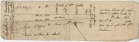
3.71 Acres of highland near marsh adjacent to Meeting Street Road. Names associated with this plat are Karl W. Ruth, A.F.C. Kramer, and S. Louis Simons.
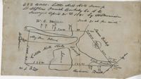
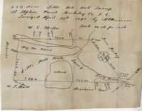
483 acre plot of Little Hell Hole Swamp, includes islands and surrounding property owners doesn't include land detail. Names associated with this plat are H.S. Morrison, Isaac Bishop, W.C. Miller, W.J. Ball, and Anderson. Notable geographic locations include St. Stephens Parish, Hog Pen Island, Little Hell Hole Swamp, and Berkeley County.
480 acre lot called Little Hell Hole Swamp, includes two islands and surrounding property owners, doesn't include land type. Names associated with this plat are H. Morrison, W.C. Miller, W.J. Ball, Issac Bishop and Anderson. Notable geographic locations include Hog Pen Island, Berkeley County, St. Stephen's Parish, and Little Hell Hole Swamp.
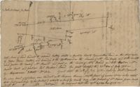
Plat contains land on the Santee River; acreage unknown. No structures are included. Names associated with this plat are S.G. Staney, A.M. Rickenbacher, and Fred J. Smith. Notable geographic locations include the Santee River.
Plan of approximately 1500 acres on Black River near Georgetown part now belonging to Kinloch and Gadsden. Names associated with this plat are Gadsden, Kinloch, Alston, Thomas Gadsden, James Lloyd, and Morreau [?] Sarrazin.
Office copy of a survey of 31 acres of land for Dr. R. H. Martin in Berkeley County. Notable geographic locations include Wappoo Road and Mill Tract. Names associated with this plat are R.H. Martin, G.G. DuPont, and W.B. Guerard.
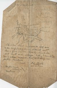
Plat contains 59 (1/2) acres. Plat contains the road to Ladson running west to east through the property the plat also includes the location of the house as well as the brickyard. Names associated with this plat include E.J. Jackson, M. Brailsford, Caines, Edon, F.C. Shutty and W.B. Guerard. Notable geographic locations include St. James Parish and Goose Creek.
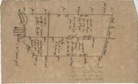
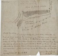
Lands of Paul Guerard called “The Hut," shows a public road and creeks, includes measurements. Names associated with this plat are Parker, W.B. Guerard, William Blacklock, Micah Jenkins, Thomas Humscoube, and Paul C. Grimball.