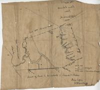
Copy of a plat of 355 Acres of land in Berkeley County near the West side of Cooper River, shows surrounding properties, doesn’t include land type or detailed notations. Names associated with this plat are Edward Keating, William Kimlough, Buvet, Matthew Beard, Colonel Chicken, Chapennoun Elliott, Robert Daniell, Longrove Thomas, Edward Keyting, Andrew Allens, William Gibbons, James Kenloch, William Adams, Allen Anderson, William Gibbons, Matthew Benson, Thomas Smith, John Vecandge [?], Francis Ternandol, and Allen Andrew. Notable geographic locations include St. James Parish, Goose Creek, Cooper River, and Berkeley County.
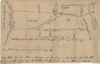
Copy of a plan of 195 acres of land near the Cooper River including dams, a house, marsh and saw pit. Names associated with this plat include Mary Rupell, Robertson, Atkin, Dr. Brabangs, Withers, Jenson, Lanue and G. Arch.
A report from the mayor, city council, and various governmental departments of Charleston, S.C. for the year 1930. ??The Year Book opens with an address from the mayor, Thomas P. Stoney, followed by reports from various departments.
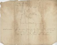
Sketch of the survey ad laying out of a small tract called Red Branch on the west side of the Cooper River containing 6 acres lately sold by Middleton to Leval part of 400 acres tract granted to Dr. Snow. Names associated with this plat are Peter Pamplat, Peter Gray, Snow, and Middleton.
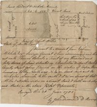
Plat of 640 acres of land belonging to Thomas Roberts situated in Berkeley County on the Cooper River bounding to the North and NE on land lad out to Nicholas Aremile to the south and SW on lands of Robert Miles and all other sides on vacant land. Names associated with this plat are John Berry, Ephraim Mitchell, Thomas Roberts, Nicholas Roberts, Nicholas Aremile, Robert Miles, William Gilbert, Barfield Homan and John Diamond. Notable geographic locations include the St. John's Parish, Cooper River, Berkeley County and Charleston District.
Plat to identify the boundaries between John Harleston, Elias Ball's property. West branch of Cooper River. Names associated with this plat are Joseph Purcell, John Harleston, Elias Ball and John Ward. Notable geographic locations include the Cooper River and St. John's Parish.
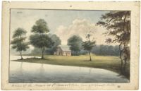
Work on paper in watercolor. Landscape with body of water in foreground leading to left side of image, trees and red building in center. Trees on either side of building and a forested area in background. Handwritten note identifies building as Pompion Hill Chapel.
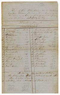
The Mouzon Plat Book surveys lands held by various individuals and families in Craven County [now in parts of Berkeley, Charleston, Georgetown, and Williamsburg counties], Colleton County and Berkeley County in South Carolina. Plats are drawn in pencil and ink. Book includes an index at the beginning and at the end are two pages of accounts and also lands to be resurveyed for the estate of Henry Mouzon Jr.
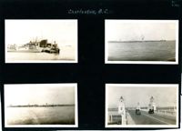
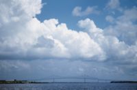
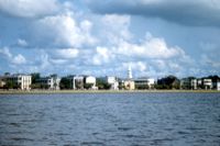
Four photographs on the page. Top left: Tugboat and other ships in a floating dry dock in the Charleston Harbor (possibly Charleston Shipbuilding). Top right: View of the Charleston waterfront from the Ashley River. Some of the landmark buildings visible in the background include St. Matthew's Church, Francis Marion Hotel, St. John's Lutheran Church, Unitarian Church, St. Philip's Church, People's Building, St. Michael's Church, and West Point Rice Mill. Bottom left: View of the Charleston waterfront from the Cooper River. Some of the landmark buildings visible in the background include Fort Sumter Hotel, St. Michael's Church, St. Philip's Church, U.S. Customhouse, and several wharves. Bottom right: Two cars on the Ashley River Bridge, one heading east and one heading west. View of the Charleston waterfront in the background.
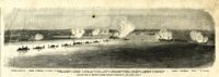
Caption: 'Panoramic view of Charleston Harbor--advance of iron-clads to the attack, April 7. Union--A. Keokuk. B. Nahunt. C. Nantucket. D. Catskill. E. Ironsides. F. Patapsco. G. Montauk. H. Passaie. K. Weehawken. Rebel--1. Morris Island sand battery. 2. Fort Wagner. 3. Battery Bee, on Cummings Point. 4. [Fort] Johnson. 5. Fort Ripley. 6. Sumter. 7. Charleston City. 8. Castle Pinckney. 9. Fort Redan. 10. Fort Moultrie. 11. Moultrie House. 12. Fort Beauregard. 13. Harbor obstructions. 14. Cooper River. 15. Ashley River.' [full date May 2, 1863.]
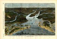
[Color image.] Caption (in French): 'Evenements des Etats-Unis: Charleston et ses fortifications. [Events of the United States: Charleston and its fortifications.] 1--Charleston. 2--Riviere Ashley [Ashley River]. 3--Chemin de fer de Savannah [Savannah Railway]. 4--Riviere Cooper [Cooper River]. 5--Riviere Wando [Wando River]. 6--Fort Pinkney [Castle Pinckney]. 7--Fort Ripley. 8--Fort Johnson (ile James) [James Island]. 9--Riviere Stone [Stono River]. 10--Fort Sumter. 11--Fort Moultrie. 12--Batterie Gregg (pointe de Gumming) [Battery Gregg (Cummings Point)]. 13--Fort Wagner. 14--Batteries rasantes du general Gilmore [grazed batteries of General Gilmore]. 15--Ouvrages pris par les federaux. [Works undertaken by the Federals]. 16--Phare Inlet [Lighthouse inlet]. 17--Batteries federales (ile Folly) [Federal Batteries (Folly Island)]. 18--Canonnieres et vaisseaux cuirasses [gunboats and ironclads]. 19--Hotel. 20--Ile et batteries Sullivan [Sullivan Island and Batteries]. 21--Moultrie. 22--Mont Pleasant [Mount Pleasant]. 23--Breach Inlet. 24--Shem Creek. 25--Batteries construite par les confederes sur l'ile James, dans le voisinage du fort Johnson [Batteries built by the Confederates on James Island, in the vicinity of Fort Johnson].
View of Battery Point (intersection of Murray Boulevard and East Battery Street) and Fort Sumter House from the Ashley River. Charleston, S.C. Originals are 35mm color slides.
Survey of 1,200 acres of land formerly owned by Thomas Stanyarne on the west side of the Cooper River. Mepkin Plantation is mentioned as an adjacent property.
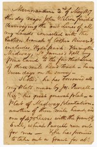
A memorandum from John Ball on Major John Wilson on resurveying the lines of lands connected with the eastern branch of the Cooper River which includes Hyde Park, Kensington, Midway and St. James Plantations.