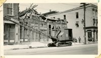
Photograph of the I.M. Pearlstine Building (203 East Bay Street), located on the southwest corner of East Bay Street and Street, after the tornado of September 29, 1938, showing the damage done to the building. Also shows 205 East Bay Street, located on the northwest corner of East Bay and Cumberland. "Bay City" heavy equipment vehicle (excavator?) parked in front of building. Pedestrian and a street worker walking on the sidewalk; repairman on the utility pole on the street corner.
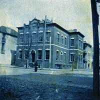
Photograph of a commercial building on a Church Street corner after the tornadoes of September 29, 1938, showing the damage done to the building. Probably located at the corner of Church and North Market Street or South Market Street. Onlookers stand on sidewalk.
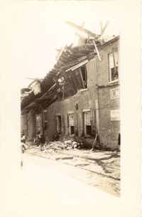
Photograph of the I.M. Pearlstine Building on Cumberland Street, located between East Bay and State Street, after the tornadoes of September 29, 1938, showing the damage done to the building. Portion of signage is visible at the right of the photograph, "I.M." and "Budwe[iser]"; signage for "Rex" is also on building (at left). Onlookers stand among the debris on the street.
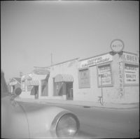
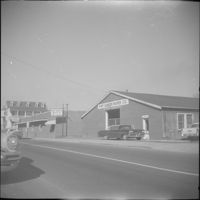
Businesses located at the northeast corner of East Bay Street and Vernon Street: Milbren's Laundry and Dry Cleaning (334 East Bay Street) and Fort Sumter Paper Co. (336 East Bay Street), since demolished.
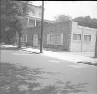
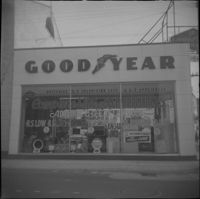
256 Meeting Street (William Gayer Carriage Factory) as a Goodyear Tire service center, before rehabilitation with a reconstructed façade. Located at the southeast corner of Meeting Street and Wentworth Street.
Wentworth Street façade of 256 Meeting Street (William Gayer Carriage Factory) when it was a Goodyear Tire service center. Located at the southeast corner of Meeting Street and Wentworth Street.
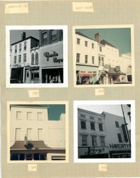
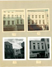
Four photographs of buildings on the east side of King Street (both color and B&W): Top left (316-320): 316 King Street (316-Rosalie Meyers) and 320 King Street (Evelyn Rubin); Top right (304-308): 304 King Street (Leroy's Jewelry Co.), 306 King Street (China Hall) and 308 King Street (Croghan's Jewel Box/The New Shoe Factory) (color photograph); Bottom left: 306 King Street (China Hall) (color photograph); Bottom right (294-296): 294 King Street (Haverty's) and 296 King Street (Levy's) (B&W photograph).
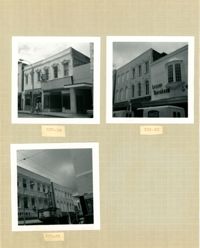
Four photographs of buildings on the east side of King Street (both color and B&W): Top left: 290 King Street (Annette's Blue Gown) (color photograph); Top right: 286 King Street (Hunley's Drugs) (color photograph); Bottom left (282-284): 282 King Street (Raley's Cafeteria) and 284 King Street (Citizens & Southern National Bank) (B&W photograph); Bottom right: 278 King Street (French Boot Shop) (B&W photograph).
Three B&W photographs of buildings on the west side of King Street: Top left (337-339): 337 King Street (King's Restaurant) and 339 King Street (Fox Hi-Fi); Top right (331-335): 331 King Street, 333 King Street, and 335 King Street (Lesser-Tanenbaum); Bottom left (327-329): 327 King Street (Barton's Candy Card & Gift Shop) and 329 (Gloria Theater).
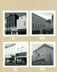
Four B&W photographs of buildings on the east side of King Street: Top left (340-342): 340 King Street (Charlie Gilik Tailor Shop) and 342 King Street (Dior's Wigs); Top right (334-338): 334 King Street (Elza's), 336 King Street, and 338 King Street; Bottom left (330-334): 330-332 King Street (Clement Furniture Co.) and 334 King Street (Elza's); Bottom right: 330-332 King Street (Clement Furniture Company).
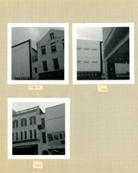
Three B&W photographs of buildings on the west side of King Street: Top left (295-297) 295 King Street (Friedman's) and 297 King Street (National Shirt Shop); Top right: 293 King Street (Hanover); Bottom left (285-287): 285 King Street (Charles Kerrison & Co.) and 287 King Street (Butler's Shoes).
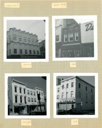
Four B&W photographs of buildings on the east side of King Street: Top left: 270-274 (Walgreens); Top right: 268 (McIntosh's); Bottom left (256-258): 256 King Street (Daisy Bogin) and 258 King Street (Snelgrove's); Bottom right: 254 King Street (Household Finance Co.)
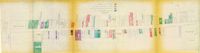
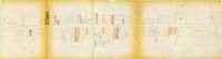
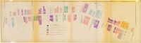
One of four maps of King Street building footprints, hand-colored to designate status. This map illustrates the historical significance of buildings on King Street from Calhoun Street to Columbus Street.
One of four maps of King Street building footprints, hand-colored to designate status. This map illustrates area conditions of buildings on King Street from Calhoun Street to Columbus Street.
One of four maps of King Street building footprints, hand-colored to designate status. This map illustrates the historical significance of buildings on King Street from Calhoun Street to Queen Street.