Receipt book belonging to Mary Motte Alston Pringle containing recipes, methods and remedies for food, housekeeping, and medicine from family, friends, articles and world travelers. Pringle often notes on effectiveness and provides personal anecdotes. Pages numbered 74 through 97 in Pringle's book are blank and therefore omitted. The table of contents can be found at the end of the book.
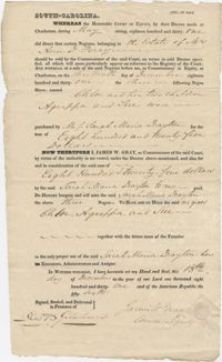
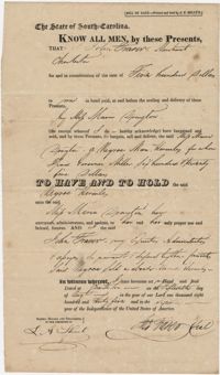
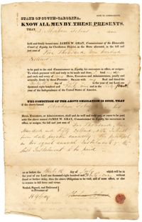
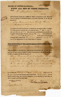
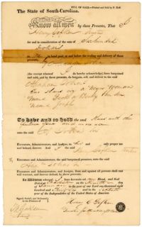
A bill of sale to Sarah Marie Drayton for the purchase of five slaves from the estate of Mrs. Ann D. Perry. James W. Gray, the commisioner of the Court of Equity facilitated the sale. The sale includes the guarantee to the purchaser of "the future issue of the Females"--meaning any future children will be the property of the purchaser. The back of the document includes several worn statements regarding the legality of the sale.
A letter from Thomas S. Grimke to Philadelphia bookseller Thomas Kite, asking his opinion of Mr. Price, an attorney, but also giving details on military preparations and a fear of violence over the nullification issue in Charleston.
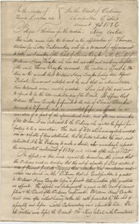
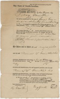
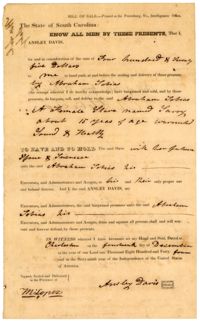
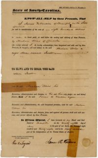
A bill of sale to Sarah Marie Drayton for the purchase of four slaves named Flora, Shedrack, Mary-Ann, and Emma, from Susan S. Keith and Charles M. Furman.
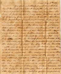
Letters of Mary Smith Grimke, wife of John Faucheraud Grimke, to her daughter, Anna Rutledge Grimke Frost (1795-1882), in Philadelphia, regarding the drowning death of her son, Benjamin (1798-1825) and his child, her grieving daughter-in-law Mary Augusta Barron Grimke (1806-1843) and the return of the bodies to Charleston, to be buried in St. Paul's cemetery. With references to settling of her husband's (?) estate, a note to her granddaughter as well and references to "Sally" (Sarah) and Angelina Grimke, especially the latter's turning to religion, attending Presbyterian services, giving up fashionable company and dress and becoming more like her sister Sarah.
Letters of Mary Smith Grimke, wife of John Faucheraud Grimke, to her daughter, Anna Rutledge Grimke Frost (1795-1882), in Philadelphia, regarding the drowning death of her son, Benjamin (1798-1825) and his child, her grieving daughter-in-law Mary Augusta Barron Grimke (1806-1843).
Letter from Thomas S. Grimke, President of the South Carolina Temperance Society, to William Gill, James Johnson, William Greu, and Isaac A. [Kerlark?], the committee of the Temperance Society of 'F' Company, 2nd Regiment of Artillery, stationed at Fort Moultrie, recommending that their organization receive auxiliary status within a soon-to-be-established state temperance society.
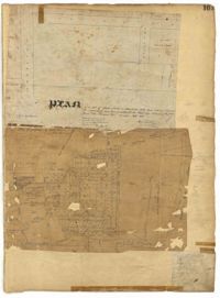
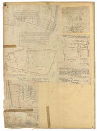
Copy of a plan of lots No.1-7, 9-11 on Cumberland Street in Charleston, Ward No.3. Indicates some buildings including a brick stable at No. 9 and DeBorr’s house and lot. “Lands of Mr. Edwards" is written above the lots. Names associated with this plat include De Borr, Edwards, and Charles Parker. Notable geographic locations include Church Street, Corr Alley or Philadelphia Street, Cumberland Street, and Ward Number 3.
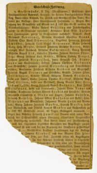
German-language court brief listing German citizens indicted on charges of refusing to appear for their mandatory service in the military. Found guilty, they were sentenced to pay a fine of 200 marks and may face 40 days in prison.
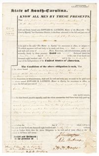
A document signed by John A. Wagener, John Hurkamp, and H.H. Hoops, agreeing to pay back seven-hundred and fifty dollars in return for a loan from Edward R. Laurens. A note on the back indicates that Laurens received a payment "in full of the within bond" in April 1842. The note also refers to John Hurkamp as the treasurer of the German Evangelical Lutheran Church.
A document signed by John A. Wagener, John Hurkamp, and H.H. Hooks, agreeing to pay back seven-hundred and fifty dollars in return for a loan from Edward R. Laurens. A note on the back indicates that Laurens received "the principal [sic.] and interest to date of the within bond" in February 1843.
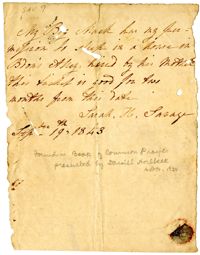
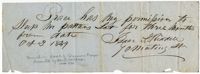
Slave pass written by Sarah H. Savage giving permission for an enslaved person named Mack to stay on Bedon's Alley for two months. The pass notes that Mack was "hired by his Mother."
A letter from Dr. Willis Wilkinson to his daughter Anna. He discusses her upcoming visit, and talks about a nurse who may be available to work for Mary, if Mary prefers a white nurse.
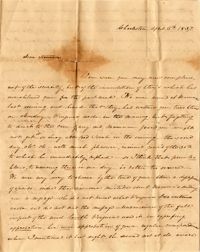
In this letter, Emma apologizes for not keeping in touch with Anna since Emma's marriage, and reports that she has traveled frequently, from Beaufort to Charleston to Savannah and back. She also laments the damage done to Charleston by a fire, particularly the destruction of its two Methodist churches.
A letter from Mary Wilkinson Memminger to "Stanner" - Anna Bella Wilkinson, her sister. She tries to clear up some confusion brought about by letters from their mother and Virginia. She says she does not have much news, and talks about Ellen (her daughter).
A letter from Anna Bella Wilkinson to her mother, sharing family news from Charleston. Anna reports that Mary has a family of goslings, and that Ellen was recently vaccinated. She also discusses the high cost of renting a house, and says that small houses are renting for $600 per year.
A letter from Anna Bella Wilkinson to her father, who is in Charleston for business. She discusses her trips to Town, and passes on an apology from her mother for not packing Dr. Wilkinson's shaving apparatus.
A letter from Dr. Willis Wilkinson to his daughter, from New York. He writes that he heard of the gale and the cholera outbreak in the Carolinas and for those reasons, he is coming home earlier than planned.
In this letter from Mary Wilkinson Memminger to her mother, Eleanora Wilkinson, Mary shares news from Charleston. She discusses two deaf-mute children who came to stay with her on their way to an institute in Hartford.
A letter from Mary Wilkinson Memminger to "Stanner" - Anna Bella Wilkinson, her sister. She writes from Greenville, reporting that the weather has been very stormy and rainy. She talks about her children, and plans for their stay at Mamma's house in Charleston.
A letter from Mary Wilkinson Memminger to her mother. She mentions Stanna's [Anna Wilkinson's] trouble with her foot, and describes her daily afternoon ritual with her children, including sitting on the piazza and having tea. She also describes some health problems her daughter Ellen has been suffering.
Letter from Virginia Wilkinson Belin to her mother. She talks of taking her daughters, Hess and Ginger (Jinny), to their cousin Johnny's birthday party, where there was iced cream and cake.
Anna Wilkinson writes to her mother concerning her mother's offer to come stay with her during her illness. Anna says that she is welcome to stay with her, but that the room is warm so her mother may be more comfortable staying at her own house. She also mentions a way to use quicksilver to keep away bugs.
St. Matthew's Lutheran Church members of the congregation obligating themselves to financially contribute to purchase a plot of real estate for the construction of a church. One third of the sum due when lot is purchased, the second third payable after one month and the remaining third after the second month following the first payment.
A letter from Thomas S. Grimke in response to Langdon Cheves in Lancaster, Pennsylvania. Grimke references ideas about the rule of law and philosophers that influenced the Reformation.
A letter from Theodore Drayton-Grimke to his father, Thomas S. Grimke, from "Middletown" (Middleton Plantation in Charleston, South Carolina?). Drayton-Grimke describes his studies in Trigonometry and reading Homer.
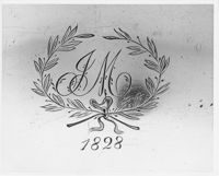
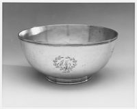
A black and white photograph close-up of the engraving on a punch bowl of a laurel with the initials 'J.M.' engraved within and the date of '1828' engraved below. The 'M' is thought to stand for Miller.
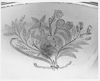
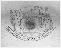
A black an white photograph of an engraving on a punch bowl featuring a vignette of a women gathering what appear to be artichokes while the man on the left looks to be primed to chop wood (center). The word 'Perseverance' is engraved underneath.
A black and white photograph of an engraving on a punch bowl of a laurel with the initials 'J.M.' engraved within and the date of '1828' engraved below. The 'M' is thought to stand for Miller.
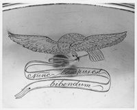
A black and white photograph of an engraving on a punch bowl featuring a bird holding a banner that reads, 'Nunc tempus est bibendum.' ['Now is the time for drinking.']
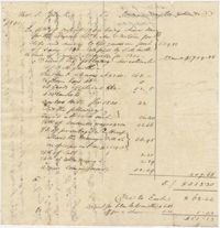
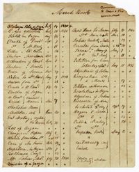
A cash book for Robert F.W. Allston for the years 1823-1843. The book includes account transactions conducted by Allston including payment of overseer wages, the hiring out of enslaved people, transportation, taxes, governesses, nurses, crops, sundries, and cloth distributed to slaves. This book also includes accounts between Allston and other individuals including the Estate of Charlotte A. Allston (primarily for the purchases of blankets, shoes, and cloth for enslaved people) and an account with Mary P. Jones. The last several pages of the book contain cash ledgers. Allston explicitly notes accounting related to Matanza Plantation, later known as Chicora Wood. Other account records do not explicitly state plantation sites.
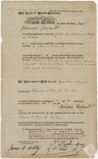
A bill of sale to Thomas S. Grimke for the purchase of a slave named August from Francis Giraud, who is described as "sound sober and no runaway." The back of the form includes a signed statement by attorney John Ward regarding the bill of sale.
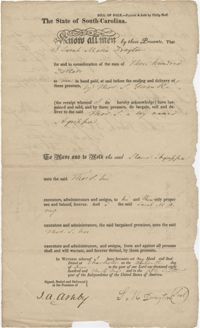
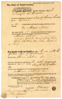
A bill of sale to Thomas S. Grimke for the purchase of a slave boy named Agrissa from Sarah Marie Drayton. The back of the document includes a signed statement, possibly from an attorney, verifying the legality of the bill of sale.
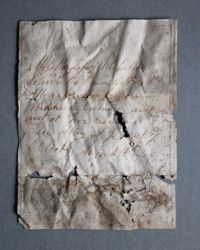
Handwritten invitation on folded, embossed paper dated August 16, 1849. Discovered under floorboards in front of the fireplace in the east enslaved quarter during 2020 investigations of the Nathaniel Russell House kitchen house. The letter transcription reads, "Miss Mary Lopez respectfully/soliceits the honor of Mr. & Mrs./Allescader Compaony on/Wednesday Evening next/inst. at her residence/Prices Alley at 1/2 past 7/O'Clock August 16th, '49
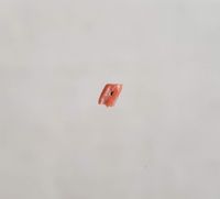
Coral bead discovered during 2018 investigations of an enslaved quarter in the Nathaniel Russell House kitchen house. Coral is most often associated with children's necklaces and teething rattles in the 18th and 19th century as it was thought to have protective/medicinal properties.
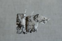
A fragment of a 1930's waistcoat that was discovered during 2017-2018 investigations of the Russell House kitchen house. Made of black worsted wool with a black silk lining and brass buttons, this waistcoat was likely the uniform of an enslaved butler or body-servant. The absence of any gold on the buttons may imply a waistcoat that belonged to an enslaved footmen or butler.
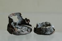
Rounded cardboard box with lid containing remnants of antimony, a substance used for medicinal purposes. Discovered during 2017-2018 investigations of an enslaved quarter in the Nathaniel Russell House kitchen house
Articles of agreement for the construction of a church on the "corner of Anson and Hasel Streets" between the Building Committee of St. Matthew's Lutheran Church, then known as the German Evangelical Lutheran Church, and John Dawson. Includes specifications for details like windows, painting and a lightning rod, and also contains notes on installment payments, each signed by Dawson.
Letters and documents surrounding the legal history of a piece of property eventually acquired by St. Matthew's Lutheran Church, beginning in 1834 with the settling of the estate of William A. Moultrie by the trustee William Brailsford, up until the release of a lien on the Hasell Street property, in September of 1841, upon John Bryan's bond payment of $12,000 to the business partners George Ingraham and Thomas Webb.
Resolution from October of 1841 stating the intention to form a religious society, the German Evangelical Lutheran Church- eventually, St. Matthew's Lutheran Church- and the appointment of a committee, chaired by John A. Wagener, to collect the funding necessary to construct the church. Includes Wagener's mortgaging of a property to secure a loan of $1,600 from the State Bank of South Carolina for this purpose.
Meeting minutes not included in the minutes book listing brief notes on the topics discussed by the Board of Trustees and the dates when they were discussed.
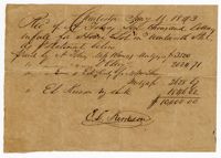
Receipt noting the purchase of a lot on Wentworth Street in Charleston, SC. by Abraham Tobias. The receipt notes the payment of mortgage and the total price paid for the lot.
A letter from Thomas Grimke to the South Carolina Comptroller General references purchasing books for a [law?] library and mentions a fund for the court house administered by his father.
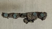
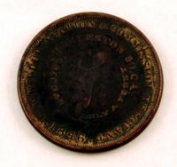
Slave auctioneer's token, 1846. These tokens were distributed as one-cent pieces and served as advertisements for the businesses and services depicted on the coins. Face view of token reads "W.W. Wilbur Auction & Commission Merchant; Charleston, So. Ca.; Going at Only A Penny" encircling the image of an auctioneer. Obverse view of token reads "Merchants & Manufactors Agents; Collection Broker Notary Public" encircling the image of a tree.
Meeting minutes volume kept by the Kahal Kadosh Beth Elohim Board of Trustees, 1838-1843. This meeting minutes volume is the first volume created by the KKBE Board of Trustees following the fire of 1838, which had destroyed the old synagogue and all earlier minutes books. The entries in this volume concern all matters regarding synagogue business, finances, memberships, rebuilding the synagogue, and establishing a school for the congregation youth. The minutes also include discussions regarding the proposal of purchasing an organ for the new synagogue, which would contribute to a schism within the congregation and begin KKBE's turn towards Reform Judaism.
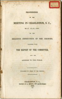
Minutes from a governmental committee regarding the teaching of Christianity to slaves. Consists of answers to questions asked of prominent slave owners throughout the state. There is a focus on the oral education of slaves as well as a white presence in any black congregation to ensure the slaves did not organize any retaliatory actions. Focuses on the demographics of the Christian slave population. Originally bound in v. 22 of the Thomas Smith Grimke pamphlet collection.
Scrapbook understood to be compiled by Abraham Moise Jr. containing handwritten comments and a collection of newspaper clippings. Some of the clippings discuss such subjects as women, and the lives and obituaries of prominent South Carolinians. Most of the book is composed of clippings related to the political controversy concerning the doctrine of Nullification and the Tariff Bill of 28. The book also includes a handwritten essay discussing the origin of the Hebrew word "Elohim."
A ribbon-bound document conveying a tract of land to the German Evangelical Lutheran Church. The document begins by affirming that John A. Wagener, John Hurkamp, and H.H. Hoops paid off their mortgage on the land. The document also describes the land's location as being near "lands now or lately in use by the Hebrew Congregation as a cemetery" and near land used as a cemetery for people of color.
A document signed by John A. Wagener, John Hukamp, and H.H. Hoops, agreeing to pay back one-thousand one-hundred and twenty-five dollars in return for a loan from Edward R. Laurens. This money was taken out for a tract of land in the Village of Hampstead.
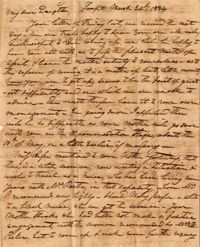
A handwritten, one-page letter from Robert Pringle of Great Britain to his Charleston relatives in which he explores their genealogical connection. He encloses a family tree, a list of marital dates, and a newspaper clipping to explain the family history.
Page 225 of the City Engineer's Plat Book with one plat. The plat shows lots and marsh located east of King Street and north of Line Street. It also shows Meeting Street.
Page 161 of the City Engineer's Plat Book with two plats. Plat 1 shows lots located near the intersection of South Street and Drake Street, and also shows America Street. Plat 2 shows a "Plan of Hampstead," which shows Meeting Street, a public square, Blake Street, Drake Street, Bay Street, Amherst Street, Reid Street, and Reid Street.
Page 151 of the City Engineer's Plat Book with two plats. Plat 1 shows lots and structures located on and near Anson Street. Plat 2 shows lots and structures located between Coming Street and the Ashley River Channel, and between Elliott Street and Mill Creek. The plat also shows 50 acres of marsh, several bodies of water, Boundary Street, Pinckney Street, Cannon Street, and President Street.
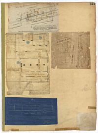
Page 127 of the City Engineer's Plat Book with four plats. Plat 1 shows lots and wharves, including Accommodation Wharf and Brown's Wharf. Plat 2 shows structures on Anson Street. Plat 3 shows lots located near the intersection of Pinckney Street and Anson Street. Plat 4 shows lots located on and near Gadsden Street, between Pinckney Street and King Street.
Page 130 of the City Engineer's Plat Book with three plats. Plat 1 shows lots located on a city block between Meeting Street and Scarborough Street and between Boundary Street and George Street. Plat 2 shows lots and structures located on East Bay Street. Plat 3 shows lots located on the Cooper River channel of the Charleston Harbor, near Concord Street and Wharf Street.
Page 118 of the City Engineer's Plat Book with four plats. Plat 1 shows lots and structures on East Bay Street. Plat 2 shows lots along Meeting Street. Plat 3 shows lots located near the intersection of Inspection Street and Marsh Street. Plat 4 shows lots and structures along Anson Street, between George Street and Boundary Street.
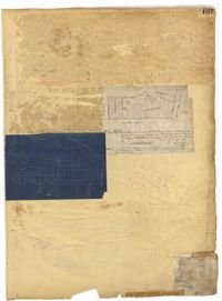
Page 107 of the City Engineer's Plat Book with two plats, labelled 3 and 4. Plat 3 features a lot and buildings located on the intersection or Tradd Street and East Bay Street. Plat 4 shows lots located near Gibbes Street, Tradd Street, New Street, and Savage Street. Plat 4 also shows three lines, labelled "Edge of high land," "Low water by Parker," and "Edge of Channel by Purcell and Parker."
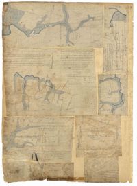
Page 88 of the City Engineer's Plat Book with eight plats. Plat 1 shows a stream and marshland starting at the Ashley River. Plat 2 features land located near the Ashley River and Grove Street. It also features several structures, some marshland, and a creek. Plat 3 shows land located near Grove Street, including some structures, some marshland, and a stream. Plat 4 shows land located Grove Street, including some buildings, a creek, and marshland. Plat 5 shows lots located between a stretch of marsh and Rutledge Avenue. Plat 5 also shows Congress Street, Legare Street, Huger Street, Moultrie Street, and a race track. Plat 6 features Washington Race Course, located between Grove Street and Moultrie Street, and between Congress Street and an unlabeled Street. Plat 7 shows "34 acres of Marsh" located between the Ashley River and a public cemetery. Plat 8 shows marshland located on the Ashley River, near "new Spring Street" and a creek.
Page 69 of the City Engineer's Plat Book with eight plats. Plat 1 shows land located on either side of Burns Lane, and also shows George Street. Plat 2 features a lot and some buildings on George Street. Plat 3 features lots located on and near King Street, between Beaufain Street and Lynch Street. Plat 4 shows a city block located between Beaufain Street and Wentworth Street, and between Pitt Street and Kirkland Lane. Plat 5 shows lots and some buildings located near the intersection of Smith Street and Montague Street. Plat 6 shows lots on Coming Street, between Montague Street and Wentworth Street. Plat 8 shows lots and some buildings located on Pitt Street, including a lot labelled "The Brown Fellowship Society Cemetery."
Page 66 of the City Engineer's Plat Book with fourteen plats. Plat 1 features buildings located near the intersection of King Street and Clifford Street. Plat 2 shows lots and structures located near the intersection of "Comings Street" and Wentworth Street. Plat 3 shows a lot and structures located on Pitt Street. Plat 4 shows lots located on a city block between Smith Street and Pitt Street, and between Montague Street and Wentworth Street. Plat 5 shows lots located on a city block between Montague Street and Wentworth Street, and between South Street and Rutledge Street. Plat 6 features a lot located near the intersection of "Comings Street" and Montague Street. Plat 7 shows lots and some structures located near the intersection of Bull Street and Coming Street. Plat 8 shows a lot and buildings located on Bull Street. Plat 9 Shows lots located near the intersection of Smith Street and Boundary Street. Plat 10 shows lots located on a city block between Lynch Street and Rutledge Street, and between Bull Street and Montague Street. Plat 11 shows lots and structures located near the intersection of Pitt Street and Bull Street. Plat 12 is features a lot located at the intersection of Pitt Street and Bull Street. Plat 13 Features lots located near the intersection of Bull Street and Lynch Street. Plat 14 shows lots located on Queen Street.
Page 52 of the City Engineer's Plat Book with seven plats. Plat 1 features a lot located on Queen Street. Plat 2 shows land between New Street and the Ashley River Channel, including stretches of Tradd Street, Broad Street, New Street, Savage Street, Rutledge Street, and Lynch Street. Plat 2 also shows some marshlands in the area. Plat 3 shows lots located along Greenhill Street, near the intersection with Tradd Street. Plat 4 shows an area similar to Plat 2, with certain buildings and marshlands labelled. Plat 5 shows a lot located on the intersection of Tradd Street and New Street, featuring several buildings and other structures. Plat 6 shows land located near Tradd Street, with marshes and shoals labelled. Plat 7 features lots between Tradd Street and Gibbes street, and has a label reading "City marshland." Plat 7 also shows New Street, Savage Street, and Council Street.
Page 51 of the City Engineer's Plat Book with seven plats. Plat 1 shows land located between Tradd Street and the Ashley River, and labels several features of geography such as a patch of marsh and some land labelled "Hard at low water." Plat 1 also shows a lot labelled "City Lands." Plat 2 shows lots and buildings located near the intersection of Tradd Street and Savage Street. Plat 3 shows land located on the west side of New Street. Plat 4 features a lot located at the intersection of New Street and Tradd Street. Plat 5 features lots located near the intersection of New Street and Tradd Street. Plat 6 shows lots located on and near Tradd Street. Plat 7 shows structures located near the intersection of New Street and Broad Street, including a building labelled "Theatre."
Page 54 of the City Engineer's Plat Book with six plats. Plat 1 shows lots located near the intersection of Broad Street and Friend Street. Plat 2 shows land between the Ashley River's low water mark and Smith Street, and between Beaufain Street and Broad Street. It also labels Comings Creek, and an "Edge of High Land." Other Streets on Plat 2 include "Barre Street," Gadsden Street, Beaufain Street, Lynch Street, Queen Street, and Rutledge Street. Plat 3 shows numerous city blocks, "School Land," and a large creek near the Ashley River. Other streets on Plat 3 include Beaufain Street, Wentworth Street, Montague Street, Bull Street, and Pitt Street. Plat 4 shows a similar stretch of land to Plat 3. Plat 5 shows features a lot on Beaufain Street. Plat 6 shows a lot and buildings located near the intersection of King Street and Hutson Street.
Page 50 of the City Engineer's Plat Book with seven plats. Plat 1 shows wharves and other structures located on East Bay Street. Plat 2 shows lots and buildings located on the intersection of Tradd Street and Meeting Street. Plat 3 shows lots located near the intersection of Broad Street and Rutledge Street. Plat 4 shows lots and buildings located near Gibbes Street. Plat 5 shows lots located near the intersection of Society Street and East Bay Street. Plat 6 shows lots and buildings near Broad Street. Plat 7 shows lots located between South Bay Street and the Ashley River, near Legare Street.
Page 41 of the City Engineer's Plat Book with six plats. Plat 1 shows land between Mount Street and Congress Street, and between a private street and "CITY LANDS Potter's Field." Plat 2 shows lots near Chestnut Street and near Spring Street, Ashton Street, Always Street, Lilly Street, and Pine Street. It also shows a few bodies of water. Plat 3 shows lots near Meeting Street's intersections with Market Alley, and State House Alley. It also labels a court house, the Treasury and Guard House, and St. Michael's Church. Plat 4 shows a stretch of land near President Street, Logan Street, Pinckney Street, Fishburne Street, Mount Street, Congress Street, and shows bodies of water and highlands. Plat 5 shows lots and buildings near the intersection Church Street and Water Street.
Page 49 of the City Engineer's Plat Book with six plats. Plat 1 shows land on the Cooper River. Plat 2 shows land located near Broad Street's intersections with Gadsden Street and Lynch Street, and a stream labelled "Comings Creek." Plat 3 shows wharfs and buildings along the Cooper River and near Champney Street. Plat 4 shows wharves and other structures between East Bay Street and the Cooper River. Plat 5 shows land near South Bay Street's intersections with Meeting Street and Church Street, including a lot labelled "Battery Garden" and a structure labelled "Bathing House."
Page 32 of the City Engineer's Plat Book with three plats. Plat 1 shows lots located near the intersection of Tradd Street and Limehouse Street. Plat 2 shows lots located near Elliott Street, Broad Street, and Line Street, near the intersections with Rose Lane, Laurel Street, Percy Street, and Coming Street. Plat 3 shows lots and buildings located between St. Phillip Street and King Street, and Radcliffe Street and Warren Street.
Page 34 of the City Engineer's Plat Book with four plats. Plat 1 shows lots located on South Bay Street. Plat 2 shows land located between Beaufain Street and Queen Street, near Smith Street, Wilson Street, and Franklin Street. Plat 3 shows lots located near Beaufain Street's intersections with Pitt Street and Wilson Street. Plat 4 features a lot and its buildings located on Meeting Street.
Page 26 of the City Engineer's Plat Book with two plats. Plat 1 is a plan for a public square located near the intersection of Pinkney Street and Boundary Street, and shows a creek. Plat 2 features a lot located on the Ashley River channel and "Commings Creek," located near the intersections of Pinckney Street and Boundary Street, and Bull Street and Rutledge Street. Plat 2 also labels a pond, an island, and "Cannon's Point." Plat 3 shows lots located between Boundary Street and Bull Street, near the intersections with Barre Street, Gadsden Street, Lynch Street, Rutledge Street, Pitt Street, and "Comming Street."
Page 16 of the City Engineer's Plat Book with five plats. Plat 1 shows lots close to the Ashley River located near Tradd Street and Gibbes Street, including a marsh flat labelled as "City Lands." Plat 2 shows lots located near the intersection of Tradd Street and Council Street, including "City marshlands." Plat 3 shows lots located near Gibbes Street and South Bay Street, and includes a dotted line labelled "Low Water Mark." Plat 4 shows land located between Ellery Street and Old Church Street, including a stretch of Raper Street. Plat 5 shows land near the intersection of South Bay Street and "Legare or Johnson Street," and close to the "Low Water" of the Ashley River.
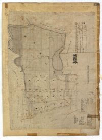
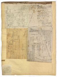
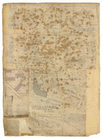
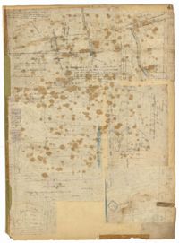
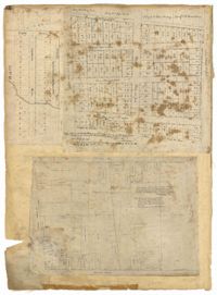
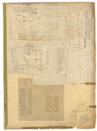
Page 19 of the City Engineer's Plat Book with six plats. Plat 1 shows lots and buildings located near the intersection of Pitt Street and Bull Street. Plat 2 shows lots and buildings located near the intersection of Meeting Street and Reid Street. Plat 3 shows lots between King Street and Congress Street, also located near Grove Street and Moultrie Street. Plat 4 shows a lot on Amen Street labelled "Thomas N. Gadsen Esq." and noting multiple brick buildings. Plat 5 shows lots located on Cumberland Street. Plat 6 shows lots located on Amen Street and two two-story brick buildings.
Album belonging to Esther Eudora Ezekiel Hart. The album includes various handwritten poems, songs, and notes from friends and family members. The album also includes a number of transcribed portions of texts and quotations from various literary figures such as Lord Byron, William Shakespeare, Alexander Pope, and John Milton.
![Bill of Sale to S.M. Drayton [Sarah Marie Drayton] for the purchase of four slaves, March 21, 1834](https://iiif.library.cofc.edu/iiif/2/36418/full/200,/0/default.jpg)


![[K. K. Beth Elohim]](https://iiif.library.cofc.edu/iiif/2/26445/full/200,/0/default.jpg)