City Engineers's Plat Book, 1671-1951, Page 107
Close Viewer
- Title:
- City Engineers's Plat Book, 1671-1951, Page 107
- Date:
- 1846
- Description:
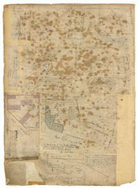
- Page 107 of the City Engineer's Plat Book with two plats, labelled 3 and 4. Plat 3 features a lot and buildings located on the intersection or Tradd Street and East Bay Street. Plat 4 shows lots located near Gibbes Street, Tradd Street, New Street, and Savage Street. Plat 4 also shows three lines, labelled "Edge of high land," "Low water by Parker," and "Edge of Channel by Purcell and Parker."
- Collection Title:
- City Engineers's Plat Book, 1671-1951
- Contributing Institution:
- The Charleston Archive at CCPL and City of Charleston
- Media Type:
- Maps
- Personal or Corporate Subject:
- Barbot, Louis J.
Payne, Robert K. - Topical Subject:
- Cadastral maps and Surveys
- Geographic Subject:
- Charleston (S.C.)
- S.C. County:
- Charleston County (S.C.)
- Language:
- English
- Date Digital:
- 2023
- Digitization Specifications:
- 300 dpi, 24-bit depth, color, i2S SupraScan Quartz A0. Archival masters are tiffs.
- Format:
- image/jpeg
- Copyright Status Statement:
- Public domain.
- Access Information:
- This City of Charleston has placed this collection on permanent loan with the Charleston County Public Library. For more information and reuse requirements contact The Charleston Archive at Charleston County Public Library, 68 Calhoun Street, Charleston, SC 29411.
- Admin ID:
- 296640
Permalink