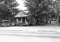
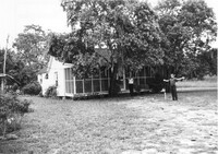
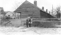
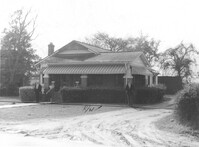
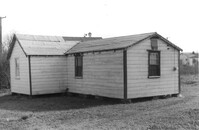
House and sweetgrass basket stand on site affected by the widening of U.S. Route 17. Presumably located in Mount Pleasant or vicinity. Surveyor notations on back of photo: "Dkt.: 10.597. Property owner: Linda Huger, Estate. Tract 84 & 85. Station: 448± Lt. Date: Sept. 17, 1968." [See collection description for explanation of surveyor notations.]
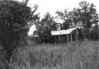
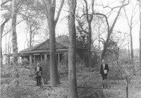
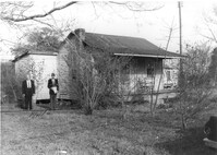
House in dilapidated condition and lot on site affected by the widening of U.S. Route 17. Presumably located in Mount Pleasant or vicinity. Surveyor notations on back of photo: "Dkt.: 10.597. Property owner: F. Gregorie, Estate. Tract: 93. Station: 458±10 Rt. Date: Sept. 17, 1968." [See collection description for explanation of surveyor notations.]
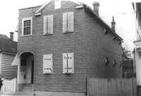
House (corner view, rear) on site affected by the widening of U.S. Route 17. Presumably located in Mount Pleasant or vicinity. Surveyor notations on back of photo: "Dkt.: 10.597. Property owner: Prince and Wilhelmina Gilliard. Tract: 92. Station: 457±10 Rt. Date: Sept. 17, 1968." [See collection description for explanation of surveyor notations.]
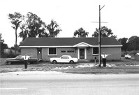
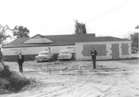
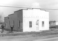
Farm Bureau building, on site affected by the widening of U.S. Route 17. Presumably located in southern Charleston County. Surveyor notations on back of photo: "Dkt.: 10.600. Property owner: Charleston County Farm Bureau. Tract: 2. Station: 507±30 Lt. Date: Sept. 18, 1968." [See collection description for explanation of surveyor notations.]
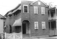
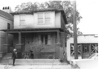
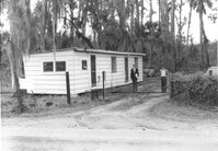
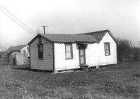
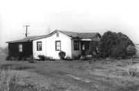
House on site affected by the widening of U.S. Route 17. Presumably located in Mount Pleasant or vicinity. Surveyor notations on back of photo: "Dkt.: 10.597. Property owner: John Gailliard. Tract: 102. Station: 466±40 Rt. Date: Sept. 17, 1968." [See collection description for explanation of surveyor notations.]
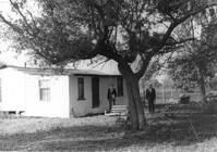
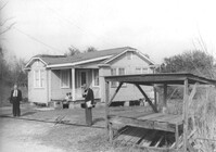
House on site affected by the widening of U.S. Route 17. Presumably located in Mount Pleasant or vicinity. Surveyor notations on back of photo: "Dkt.: 10.597. Property owner: Charles Dingle. Tract: 98. Station 462±50 Rt. Date: Sept. 17, 1968." [See collection description for explanation of surveyor notations.]
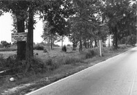
Lot on site affected by the widening of U.S. Route 17. Sign posted to tree: This land cleared by Atlantic Land Corp. Presumably located in southern Charleston County. Surveyor notations on back of photo: "Dkt.: 10.600. Property owner: Arthur J. Stark. Tract: 1. Station: 515± Lt. Date: Sept. 18, 1968." [See collection description for explanation of surveyor notations.]
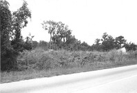
Lot on site affected by the widening of U.S. Route 17. Presumably located in southern Charleston County. Surveyor notations on back of photo: "Dkt.: 10.600. Property owner: Gas Lines, Inc. & Arthur J. Stark. Tract: 1-A. Station: 506± Lt. Date: Sept. 18, 1968." [See collection description for explanation of surveyor notations.]
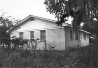
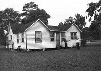
House on site affected by the widening of U.S. Route 17. Presumably located in Mount Pleasant or vicinity. Surveyor notations on back of photo: "Dkt.: 10.597. Property owner: F. Gregorie, Estate. Tract: 93. Station: 460± Rt. Date: Sept. 17, 1968." [See collection description for explanation of surveyor notations.]
House on site affected by the widening of U.S. Route 17. Presumably located in Mount Pleasant or vicinity. Surveyor notations on back of photo: "Dkt.: 10.597. Property owner: F. Gregorie, Estate. Tract: 93. Station: 460± Rt. Date: Sept. 17, 1968." [See collection description for explanation of surveyor notations.]
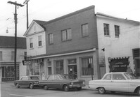
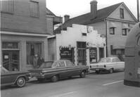
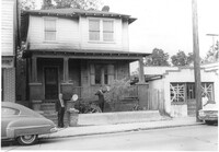
Building, on site affected by the construction of the Crosstown. Address: 209 Spring Street. Friendly Barber Shop and Spot Light Radio TV Service. Front facade has stepped parapet. Surveyor notations on back of photo: "Dkt.: 10.524. Property owner: Maybell Fields. Tract: 166. Station: 20+00 Rt. Spring Street. Date: Dec. 2, 1964." [See collection description for explanation of surveyor notations.]
Building, on site affected by the construction of the Crosstown. Address: 207 Spring Street. Sew-U-Save Shop. Surveyor notations on back of photo: "Dkt.: 10.524. Property owner: Olympia Papaeilidow. Tract: 167. Station: 20+35 Rt. Spring Street. Date: Dec. 2, 1964." [See collection description for explanation of surveyor notations.]
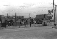
Shell gas station (rear view) on site affected by the construction of the Crosstown. Address: 233 Spring Street. Surveyor notations on back of photo: "Dkt.: 10.524. Property owner: Shell Oil Co. Tract: 155. Station: 9+00 Rt. Spring Street. Date: Dec. 2, 1965." [See collection description for explanation of surveyor notations.]
Hardee's, on site affected by the construction of the Crosstown. Address: 223 Spring Street. Surveyor notations on back of photo: "Dkt.: 10.524. Property owner: Sarah Chinnis Sanders. Tract: 157. Station: 14+60 Rt. Spring Street. Date: Dec. 2, 1964." [See collection description for explanation of surveyor notations.]
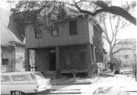
House on site affected by the construction of the Crosstown. Address: 114 Bogard Street. Surveyor notations on back of photo: "Dkt.: 10.524. Property owner: Francis Jenkins, et al. Tract: 64. Station: 75+70 CL Rt. Date: Oct. 14, 1964. In R/W - Bought." [See collection description for explanation of surveyor notations.]
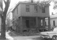
House on site affected by the construction of the Crosstown. Address: 112 Bogard Street. Surveyor notations on back of photo: "Dkt.: 10.524. Property owner: Susan D. Butler, Est. Tract: 65. Station: 76+00 CL Rt. Date: Oct. 14, 1964. In R/W - Bought." [See collection description for explanation of surveyor notations.]
House on site affected by the construction of the Crosstown. Address: 116 Bogard Street. Surveyor notations on back of photo: "Dkt.: 10.524. Property owner: Arletha Powers. Tract: 63. Station: 75+40 CL. Date: Oct. 14, 1964. In R/W - Bought." [See collection description for explanation of surveyor notations.]
House on site affected by the construction of the Crosstown. Address: 116 Bogard Street. Surveyor notations on back of photo: "Dkt.: 10.524. Property owner: Arletha Powers. Tract: 63. Station: 75+40 CL. Date: Oct. 14, 1964. In R/W - Bought." [See collection description for explanation of surveyor notations.]
Building, on site affected by the construction of the Crosstown. Address: 209 Spring Street. Friendly Barber Shop and Spot Light Radio TV Service. Front facade has stepped parapet. Neighboring buildings on either side seen; Address 207 Spring Street and 211 Spring Street. Surveyor notations on back of photo: "Dkt.: 10.524. Property owner: Maybell Fields. Tract: 166. Station: 20+00 Rt. Spring Street. Date: Dec. 2, 1964." [See collection description for explanation of surveyor notations.]
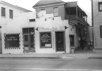
Side view of The Fork (restaurant) and lot on site affected by the construction of the Crosstown. Address: 223 Spring Street. Signs for the Castle Pinckney Motel and The Fork Restaurant at right. Presumably on Spring Street. Surveyor notations on back of photo: "Dkt.: 10.524. Property owner: The Fork Co. Inc. Tract: 156. Station: 13±00 Rt. Spring Street. Date: Dec. 2, 1964." [See collection description for explanation of surveyor notations.]
Side view of The Fork (restaurant) and lot on site affected by the construction of the Crosstown. Address: 223 Spring Street. Surveyor notations on back of photo: "Dkt.: 10.524. Property owner: The Fork Co. Inc. Tract: 156. Station: 13±00 Rt. Spring Street. Date: Dec. 2, 1964." [See collection description for explanation of surveyor notations.]
Billboard for BlueCross BlueShield on site affected by construction of the Crosstown. Billboard for Charleston Inn and 233 Spring Street (Shell gas station) in background. Presumably on Spring Street. Surveyor notations on back of photo: "Dkt.: 10.524. Property owner: Turner Advertising Co. Tract: 155. Station: 11±00 Rt. Spring Street. Date: Dec. 2, 1964." [See collection description for explanation of surveyor notations.]
House (rear corner view) on site affected by the construction of the Crosstown. Address: 110 Bogard Street. Surveyor notations on back of photo: "Dkt.: 10.524. Property owner: Thomassina Elizabeth McCray. Tract: 72. Station: 76+60 Rt. Date: Oct. 14, 1964. In R/W - Bought." [See collection description for explanation of surveyor notations.]
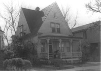
House on site affected by the construction of the Crosstown. Address: 71 Kracke Street. Surveyor notations on back of photo: "Dkt.: 10.524. Property owner: William Henry Godfrey. Tract: 66. Station: 76+10 Lt. Date: Oct. 14, 1964. Portion in R/W to be removed." [See collection description for explanation of surveyor notations.]
House (rear view) and lot on site affected by the construction of the Crosstown. Address: 18-20 Wescott Street. Surveyor notations on back of photo: "Dkt.: 10.524. Property owner: Ralph E. Thornley, et al. Tract: 11. Station: 62+10 Lt. Date: Oct. 13, 1964." [See collection description for explanation of surveyor notations.]
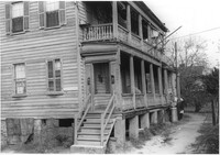
Side view of house on site affected by the construction of the Crosstown. Address: 119 Bogard Street. Surveyor notations on back of photo: "Dkt.: 10.524. Property owner: Rebecca S. Cooper. Tract: 55. Station: 73+90 Rt. Date: Oct. 14, 1964. In R/W - Bought." [See collection description for explanation of surveyor notations.]
House on site affected by the construction of the Crosstown. Address: 110 Bogard Street. Surveyor notations on back of photo: "Dkt.: 10.524. Property owner: Thomassina Elizabeth McCray. Tract: 72. Station: 76+60 Rt. Date: Oct. 14, 1964. In R/W - Bought." [See collection description for explanation of surveyor notations.]
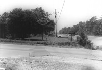
House on site affected by the construction of the Crosstown. Address: 190 Spring Street. Surveyor notations on back of photo: "Dkt.: 10.524. Property owner: E.H. Heidman, Est. Tract: 18. Station: 24± Lt. (Spring Street). Date: Oct. 13, 1964. Portion in R/W to be removed." [See collection description for explanation of surveyor notations.]
House on site affected by the construction of the Crosstown. Address: 190 Spring Street. Surveyor notations on back of photo: "Dkt.: 10.524. Property owner: E.H. Heidman, Est. Tract: 18. Station: 24± Lt. (Spring Street). Date: Oct. 13, 1964. Portion in R/W to be removed." [See collection description for explanation of surveyor notations.]
House on site affected by the construction of the Crosstown. Address: 22 Wescott Street. Surveyor notations on back of photo: "Dkt.: 10.524. Property owner: Ida J. Gantt. Tract: 10. Station: 61+20 Lt. Date: Oct. 13, 1964." [See collection description for explanation of surveyor notations.]
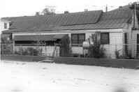
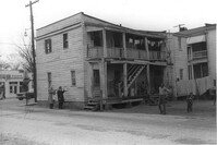
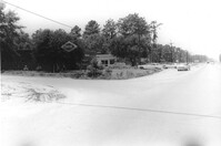
House (rear and side view) on site affected by the construction of the Crosstown. Address: 215 Spring Street. Corner of Spring Street and Vaughan Street. Paint and hardware store across the street. Surveyor notations on back of photo: "Dkt.: 10.524. Property owner: Ruby E. Jacobs. Tract: 163. Station: 18+85 Rt. Spring Street. Date: Dec. 2, 1964. Partially In R/W - Bought." [See collection description for explanation of surveyor notations.]
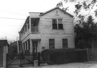
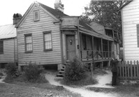
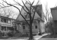
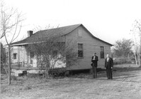
House (freedman's cottage) on site affected by the construction of the Crosstown. Address: 26 Kracke Street. Surveyor notations on back of photo: "Dkt.: 10.524. Property owner: Julia Brown. Tract: 68. Station: 77+55 Lt. Date: Oct. 14, 1964. Proximity." [See collection description for explanation of surveyor notations.]
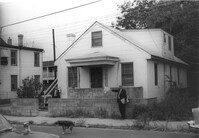
House on site affected by the construction of the Crosstown. Address: 121 Sheppard Street. Surveyor notations on back of photo: "Dkt.: 10.524. Property owner: Erline B. Wertan. Tract: 138. Station: 17+05 Rt. N.B. lane. Date: Dec. 2, 1964. In R/W - Bought." [See collection description for explanation of surveyor notations.]
House on site affected by the construction of the Crosstown. Address: 121 Sheppard Street. Surveyor notations on back of photo: "Dkt.: 10.524. Property owner: Erline B. Wertan. Tract: 138. Station: 17+05 Rt. N.B. lane. Date: Dec. 2, 1964. In R/W - Bought." [See collection description for explanation of surveyor notations.]
House on site affected by the construction of the Crosstown. Address: 119 Sheppard Street. Surveyor notations on back of photo: "Dkt.: 10.524. Property owner: Scott M. Boyle. Tract: 139. Station: 17+45 Rt. N.B. lane. Date: Dec. 2, 1964. In R/W - Bought." [See collection description for explanation of surveyor notations.]
House on site affected by the construction of the Crosstown. Address: 119 Sheppard Street. Surveyor notations on back of photo: "Dkt.: 10.524. Property owner: Scott M. Boyle. Tract: 139. Station: 17+45 Rt. N.B. lane. Date: Dec. 2, 1964. In R/W - Bought." [See collection description for explanation of surveyor notations.]
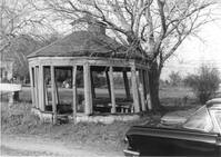
Gazebo, on site affected by the widening of Route 171 (Folly Road). Surveyor notations on back of photo: "Dkt.: 10.494. Property owner: Sophie Sabel, Est. Tract: 97. Station: 370+50 Lt. Date: Mar. 21, 1962. In R/W - Bought. [See collection description for explanation of surveyor notations.]
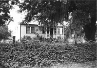
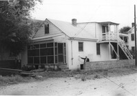
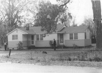
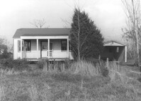
House on site affected by the widening of Route 171 (Folly Road). Surveyor notations on back of photo: "Dkt.: 10.494. Property owner: H.W. Halter, et al. Tract: 79. Station: 299+00 Rt. Date: Mar. 21, 1962. Proximity. [See collection description for explanation of surveyor notations.]
House on site affected by the widening of Route 171 (Folly Road). Surveyor notations on back of photo: "Dkt.: 10.494. Property owner: D.J. Byrd, et al. Tract: 73. Station: 280+60 Rt. Date: Mar. 21, 1962. Proximity. [See collection description for explanation of surveyor notations.]
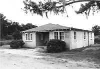
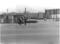
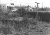
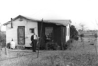
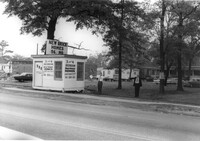
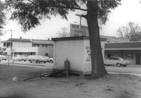
Wooden stand, on site affected by the widening of Route 171 (Folly Road). Possibly a fruit/vegetable or sweetgrass basket stand. Surveyor notations on back of photo: "Dkt.: 10.494. Property owner: Ossie Moore. Tract: 80. Station: 300+90 Rt. Date: Mar. 21, 1962. Owner to move. [See collection description for explanation of surveyor notations.]
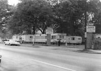
Site affected by the widening of Route 171 (Folly Road). Folly Road Pantry, B&H Grocery, and Phillips 66 gas Station: in background. Surveyor notations on back of photo: "Dkt.: 10.494. Property owner: H.W. Halter, et al. Tract: 78. Station: 298+44 Rt. Date: Mar. 21, 1962. Loss in R/W. [See collection description for explanation of surveyor notations.]
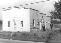
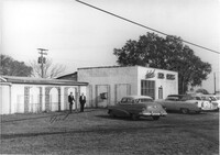
Building, on site affected by the widening of Route 171 (Folly Road). Dave Richardson and Son General Contractor. Front facade has stepped parapet. Surveyor notations on back of photo: "Dkt.: 10.494. Property owner: Dave Richardson, et al. Tract: 93. Station: 314+40 Lt. Date: Mar. 21, 1962. To be cut off at R/W by SCHD [SC Highway Department?]. [See collection description for explanation of surveyor notations.]
House on site affected by the widening of Route 171 (Folly Road). Surveyor notations on back of photo: "Dkt.: 10.494. Property owner: Sophie Sabel, Est. Tract: 97. Station: 372+20 Lt. Date: Mar. 21, 1962. To be cut off at R/W by SCHD [SC Highway Dept.?]. [See collection description for explanation of surveyor notations.]
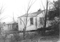
House on site affected by the widening of Route 171 (Folly Road). Surveyor notations on back of photo: "Dkt.: 10.494. Property owner: G.L. Brown, et al. Tract: 69. Station: 218+90 Rt. Date: Mar. 21, 1962. Proximity. [See collection description for explanation of surveyor notations.]
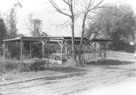
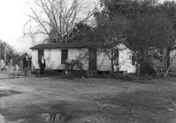
Building on site affected by the widening of Route 171 (Folly Road). Surveyor notations on back of photo: "Dkt.: 10.494. Property owner: John Harleston. Tract: 62. Station: 195+50 Rt. Date: Mar. 21, 1962. Moving item. [See collection description for explanation of surveyor notations.]
House on site affected by the widening of Route 171 (Folly Road). Surveyor notations on back of photo: "Dkt.: 10.494. Property owner: Sophie Sabel, Est. Tract: 97. Station: 372+20 Lt. Date: Mar. 21, 1962. To be cut off at R/W by SCHD [SC Highway Dept.?]. [See collection description for explanation of surveyor notations.]
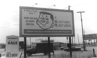
H.W. Halter Cheese Butter Oleo Poultry Eggs [company], on site affected by the widening of Route 171 (Folly Road). Surveyor notations on back of photo: "Dkt.: 10.494. Property owner: H.W. Halter, et al. Tract: 78. Station: 209+20 Rt. Date: Mar. 21, 1962. Proximity. Loss of parking space. [See collection description for explanation of surveyor notations.]
House named "Shady Grove," on site affected by the widening of Route 171 (Folly Road). Surveyor notations on back of photo: "Dkt.: 10.494. Property owner: Mrs. Martha A. Gibson. Tract: 72. Station: 279+80 Rt. Date: Mar. 21, 1962. Proximity. [See collection description for explanation of surveyor notations.]
House on site affected by the widening of Route 171 (Folly Road). Surveyor notations on back of photo: "Dkt.: 10.494. Property owner: H.W. Halter, et al. Tract: 79. Station: 299+00 Rt. Date: Mar. 21, 1962. Proximity. [See collection description for explanation of surveyor notations.]
House on site affected by the widening of Route 171 (Folly Road). Surveyor notations on back of photo: "Dkt.: 10.494. Property owner: John Richardson, Est. Tract: 94. Station: 338+70 Lt. Date: Mar. 21, 1962. To be cut off at R/W by SCHD [SC Highway Dept.?]. [See collection description for explanation of surveyor notations.]
House on site affected by the widening of Route 171 (Folly Road). Surveyor notations on back of photo: "Dkt.: 10.494. Property owner: John Richardson, Est. Tract: 94. Station: 335+50 Lt. Date: Mar. 21, 1962. In R/W - Bought. [See collection description for explanation of surveyor notations.]
House on site affected by the widening of Route 171 (Folly Road). Surveyor notations on back of photo: "Dkt.: 10.494. Property owner: John Richardson, Est. Tract: 94. Station: 335+50 Lt. Date: Mar. 21, 1962. In R/W - Bought. [See collection description for explanation of surveyor notations.]
House on site affected by the widening of Route 171 (Folly Road). Surveyor notations on back of photo: "Dkt.: 10.494. Property owner: John Richardson, Est. Tract: 94. Station: 336+60 Lt. Date: Mar. 21, 1962. In R/W - Bought. [See collection description for explanation of surveyor notations.]
House on site affected by the widening of Route 171 (Folly Road). Surveyor notations on back of photo: "Dkt.: 10.494. Property owner: John Richardson, Est. Tract: 94. Station: 336+60 Lt. Date: Mar. 21, 1962. In R/W - Bought. [See collection description for explanation of surveyor notations.]
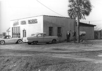
Sabel Iron Works, on site affected by the widening of Route 171 (Folly Road). Surveyor notations on back of photo: "Dkt.: 10.494. Property owner: Sophie Sabel, Est. Tract: 97. Station: 367+50 Lt. Date: Mar. 21, 1962. To be cut off at R/W by SCHD [SC Highway Dept.?]. [See collection description for explanation of surveyor notations.]
Sabel Iron Works, on site affected by the widening of Route 171 (Folly Road). Surveyor notations on back of photo: "Dkt.: 10.494. Property owner: Sophie Sabel, Est. Tract: 97. Station: 367+50 Lt. Date: Mar. 21, 1962. To be cut off at R/W by SCHD [SC Highway Dept.?]. [See collection description for explanation of surveyor notations.]
House on site affected by the widening of Route 171 (Folly Road). Surveyor notations on back of photo: "Dkt.: 10.494. Property owner: John Richardson, Est. Tract: 94. Station: 338+70 Lt. Date: Mar. 21, 1962. To be cut off at R/W by SCHD [SC Highway Dept.?]. [See collection description for explanation of surveyor notations.]
House on site affected by the widening of Route 171 (Folly Road). Wooden stand in foreground. Surveyor notations on back of photo: "Dkt.: 10.494. Property owner: Robert Richardson, et al. Tract: 90. Station: 310+00 Lt. Date: Mar. 21, 1962. Proximity. [See collection description for explanation of surveyor notations.]
Building, on site affected by the widening of Route 171 (Folly Road). Dave Richardson and Son General Contractor. Front facade has stepped parapet. Surveyor notations on back of photo: "Dkt.: 10.494. Property owner: Dave Richardson, et al. Tract: 93. Station: 314+40 Lt. Date: Mar. 21, 1962. To be cut off at R/W by SCHD [SC Highway Department?]. [See collection description for explanation of surveyor notations.]
House on site affected by the widening of Route 171 (Folly Road). Surveyor notations on back of photo: "Dkt.: 10.494. Property owner: Sophie Sabel, Est. Tract: 97. Station: 371+20 Lt. Date: Mar. 21, 1962. To be cut off at R/W by SCHD [SC Highway Dept.?]. [See collection description for explanation of surveyor notations.]
House on site affected by the widening of Route 171 (Folly Road). Surveyor notations on back of photo: "Dkt.: 10.494. Property owner: Sophie Sabel, Est. Tract: 97. Station: 371+20 Lt. Date: Mar. 21, 1962. To be cut off at R/W by SCHD [SC Highway Dept.?]. [See collection description for explanation of surveyor notations.]
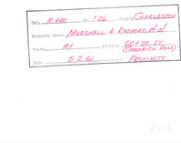
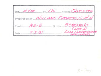
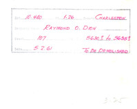
Example of information written on back of photograph: Docket Number, Route, County, Property Owner, Tract, Station, Date, and added note pertaining to right-of-way.
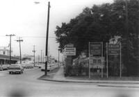
Site affected by the widening of State Road 31 (Reynolds Avenue). Surveyor notations on back of photo: "Dkt.: 10.541. Property owner: Morris P. Sokol, et al. Tract: 1. Station: 2+80 Lt. Date: Apr. 20, 1965." [See collection description for explanation of surveyor notations.]
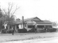
Esso Service Station: at intersection of Orange Grove Road and SC Highway 7 (Sam Rittenberg), on site affected by the widening of Routes 7 & 171. Surveyor notations on back of photo: "Dkt.: 10.551. Property owner: Humble Oil Co. Tract: 1. Station: 36±00 Rt. Date: Jul. 22, 1965. Taken from intersection of Orange Grove Rd. and Rte. 7 & 171. [See collection description for explanation of surveyor notations.]
Small structure with advertisement for "New Brick Homes," on site affected by the widening of State Road 31 (Reynolds Avenue). Surveyor notations on back of photo: "Dkt.: 10.541. Property owner: Morris P. Sokol, et al. Tract: 1. Station: 2+80 Lt. Date: Apr. 20, 1965." [See collection description for explanation of surveyor notations.]
Site affected by the widening of Routes 7 & 171. Surveyor notations on back of photo: "Dkt.: 10.551. Property owner: Lucille S. Dwight. Tract: 2. Station: 120±00 Lt. Date: Jul. 22, 1965. Looking west from Rd. S-80 of range poles on corners of ? area. [See collection description for explanation of surveyor notations.]
Example of information written on back of photograph: Docket Number, Route, County, Property Owner, Tract, Station, Date, and added note pertaining to right-of-way.
Entrance to Idamor Trailer Park and Apartments, on site affected by the widening of State Road 31 (Reynolds Avenue). Surveyor notations on back of photo: "Dkt.: 10.541. Property owner: Morris P. Sokol, et al. Tract: 1. Station: 3t-4t Lt. Date: Apr. 20, 1965. Taken from southeast side. [See collection description for explanation of surveyor notations.]
Rear view of structure with advertisement for "New Brick Homes," on site affected by the widening of State Road 31 (Reynolds Avenue). Surveyor notations on back of photo: "Dkt.: 10.541. Property owner: Morris P. Sokol, et al. Tract: 1. Station: 2+80 Lt. Date: Apr. 20, 1965." [See collection description for explanation of surveyor notations.]
Corner view of Idamor Trailer Park and Apartments, with signage for Commissary Store - Navy Exchange Country Store and for E.M. Club - Eliza Lucas Hall, on site affected by the widening of State Road 31 (Reynolds Avenue). Surveyor notations on back of photo: "Dkt.: 10.541. Property owner: Morris P. Sokol, et al. Tract: 1. Station: 4+8 Lt. Date: Apr. 20, 1965." [See collection description for explanation of surveyor notations.]
Example of information written on back of photograph: Docket Number, Route, County, Property Owner, Tract, Station, Date, and added note pertaining to right-of-way.
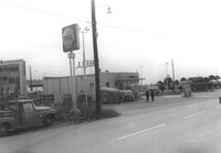
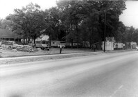
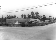
Ashley Lanes (bowling alley), on site affected by the widening of Routes 7 & 171. Surveyor notations on back of photo: "Dkt.: 10.551. Property owner: Ashley Lanes, Inc. Tract: 3. Station: 128±00 Lt. Date: Jul. 22, 1965. Looking SE from Ashley Hall Road and Rt. 7 intersection, at range poles on corners of ? area. [See collection description for explanation of surveyor notations.]
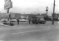
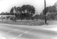
Orkin Pest Control - Termite Control, corner of Ashley Hall Road and Route 7 (Sam Rittenberg Boulevard), on site affected by the widening of Routes 7 & 171. Surveyor notations on back of photo: "Dkt.: 10.551. Property owner: Atlantic Investment & Development Co. Tract: 4. Station: 127±00 Rt. Date: Jul. 22, 1965. Range poles on corners of ? area - photographer standing in Rt. 7. [See collection description for explanation of surveyor notations.]
Example of information written on back of photograph: Docket Number, Route, County, Property Owner, Tract, Station, Date, and added note pertaining to right-of-way.
Example of information written on back of photograph: Docket Number, Route, County, Property Owner, Tract, Station, Date, and added note pertaining to right-of-way.
Orkin Pest Control - Termite Control, corner of Ashley Hall Road and Route 7 (Sam Rittenberg Boulevard), on site affected by the widening of Routes 7 & 171. Surveyor notations on back of photo: "Dkt.: 10.551. Property owner: Atlantic Investment & Development Co. Tract: 4. Station: 127±00 Rt. Date: Jul. 22, 1965. Same as Photo 5, view from across Ashley Hall Rd. looking north. [See collection description for explanation of surveyor notations.]