A document conveying a tract of land to George Dispau. The document describes how W.D. Porter, a representative of the court, auctioned the land to the church so the estate of previous owner, Cephas Whittmore, could settle his debt.
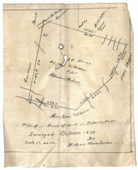
Plan of land in St. James Santee for Abraham Micheau. Names associated with this plat are Ann Colburn, Gardner, Anthony Germain, Buneli, B. Skipper, Isaac Skipper, Abraham Micheau, and William H. Simons.
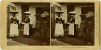
Stereoscopic image of African American cotton pickers in a cotton field on St. Helena Island, South Carolina. Handwritten caption on verso reads, "Cotton picking at the yard-St. Helena Island Fall of 1879."
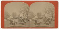
Stereoscopic image of five visible horse drawn carriages, some transporting cotton from the gin. Handwritten caption on the verso reads, "Some scene 1879-Cotten ginned and booked for shipping. Gin property of Mr. JJ Dale, J.R. Macdonald, George Wilkins."
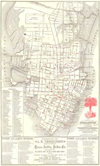
Map of the Charleston peninsula. Revised in 1879; published by Walker, Evans & Cogswell. Features locations of fire alarm boxes and public buildings, with indexes to each. Presented by A.R. Thomlinson, manufacturer of harness, saddles, bridles, etc., located at 137 Meeting Street. Measures 21.875" x 13.625"
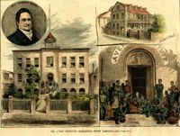
[Color image.] Caption: 'The Avery Institute, Charleston, South Carolina.--[see page 867.]' Also identified in image: Rev. Charles Avery and Teachers' Home.
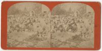
A stereoscopic image of African American women holding baskets with wares on top of their heads and children carrying wares atop their head. The text at the bottom of the image identifies them as "street vendors."
![104. Alex Marshall to Magdelen Elizabeth Wlikinson Marshall [nee Keith] -- August 30, 1879](https://iiif.library.cofc.edu/iiif/2/24939/full/200,/0/default.jpg)