Center for African and African-American Studies (CAAS) "Occasional Paper No. 7" entitled, "Negritude: Philosophy of Culture," written by Richard A. Long, Director for the CAAS at Atlanta University.
Transcriptions of Rabbi Padoll’s typewritten and handwritten sermons and addresses from his various rabbinates, including Charleston’s Kahal Kadosh Beth Elohim. A civil rights advocate, Padoll discusses ongoing struggles for social justice, contemporary events such as the assassination of Robert F. Kennedy, and parables related to the Sabbath and holiday celebrations. Padoll stored his sermons in nine binders, and the transcriptions reflect this original order. Burton L. Padoll (1929-2004), was born to Leah and Charles Padoll in Canton, Ohio. Padoll attended the Hebrew Union College in Cincinnati, Ohio, where he was ordained in 1957 and received an honorary Doctorate of Divinity in 1982. After his ordination, Padoll served as assistant rabbi in Brookline, Massachusetts. In 1961, Padoll took a position as rabbi of Kahal Kadosh Beth Elohim (KKBE) in Charleston, South Carolina, where he served for six years. During this time, Padoll strongly advocated for civil rights and criticized Charleston's Jewish community for their failure to aid the struggle for racial equality. After leaving Charleston in 1967, Padoll moved to Peabody, Massachusetts, where he became the rabbi of Temple Beth Shalom in 1969 until his retirement in 1989. Padoll lived in Mount Jackson, Virginia, until his death in 2004.
Large straw bag made of dark colored straw and decorated with shells. Lined with brown cloth. The straw was woven in Long Bay Cays and sold to craftswomen in Nassau. Originally purchased in the straw market of Nassau, Bahamas.
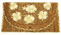
Clutch purse made from light and dark colored straw. The straw was woven in Long Bay Cays and sold to craftswomen in Nassau. Originally purchased in the straw market of Nassau, Bahamas.
Straw purse with handle and turquoise linen lining. The straw was woven in Long Bay Cays and sold to craftswomen in Nassau. Originally purchased in the straw market of Nassau, Bahamas.
Transcriptions of Rabbi Padoll’s typewritten and handwritten sermons and addresses from his various rabbinates, including Charleston’s Kahal Kadosh Beth Elohim. A civil rights advocate, Padoll discusses ongoing struggles for social justice, contemporary events such as the assassination of Robert F. Kennedy, and parables related to the Sabbath and holiday celebrations. Padoll stored his sermons in nine binders, and the transcriptions reflect this original order. Burton L. Padoll (1929-2004), was born to Leah and Charles Padoll in Canton, Ohio. Padoll attended the Hebrew Union College in Cincinnati, Ohio, where he was ordained in 1957 and received an honorary Doctorate of Divinity in 1982. After his ordination, Padoll served as assistant rabbi in Brookline, Massachusetts. In 1961, Padoll took a position as rabbi of Kahal Kadosh Beth Elohim (KKBE) in Charleston, South Carolina, where he served for six years. During this time, Padoll strongly advocated for civil rights and criticized Charleston's Jewish community for their failure to aid the struggle for racial equality. After leaving Charleston in 1967, Padoll moved to Peabody, Massachusetts, where he became the rabbi of Temple Beth Shalom in 1969 until his retirement in 1989. Padoll lived in Mount Jackson, Virginia, until his death in 2004.
Transcriptions of Rabbi Padoll’s typewritten and handwritten sermons and addresses from his various rabbinates, including Charleston’s Kahal Kadosh Beth Elohim. A civil rights advocate, Padoll discusses ongoing struggles for social justice, contemporary events such as the assassination of Robert F. Kennedy, and parables related to the Sabbath and holiday celebrations. Padoll stored his sermons in nine binders, and the transcriptions reflect this original order. Burton L. Padoll (1929-2004), was born to Leah and Charles Padoll in Canton, Ohio. Padoll attended the Hebrew Union College in Cincinnati, Ohio, where he was ordained in 1957 and received an honorary Doctorate of Divinity in 1982. After his ordination, Padoll served as assistant rabbi in Brookline, Massachusetts. In 1961, Padoll took a position as rabbi of Kahal Kadosh Beth Elohim (KKBE) in Charleston, South Carolina, where he served for six years. During this time, Padoll strongly advocated for civil rights and criticized Charleston's Jewish community for their failure to aid the struggle for racial equality. After leaving Charleston in 1967, Padoll moved to Peabody, Massachusetts, where he became the rabbi of Temple Beth Shalom in 1969 until his retirement in 1989. Padoll lived in Mount Jackson, Virginia, until his death in 2004.
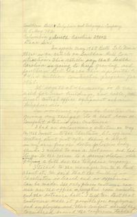
Handwritten correspondence from Septima P. Clark to Southern Bell Telephone and Telegraph Company regarding a May 1968 article on Southern Bell construction.
Transcriptions of Rabbi Padoll’s typewritten and handwritten sermons and addresses from his various rabbinates, including Charleston’s Kahal Kadosh Beth Elohim. A civil rights advocate, Padoll discusses ongoing struggles for social justice, contemporary events such as the assassination of Robert F. Kennedy, and parables related to the Sabbath and holiday celebrations. Padoll stored his sermons in nine binders, and the transcriptions reflect this original order. Burton L. Padoll (1929-2004), was born to Leah and Charles Padoll in Canton, Ohio. Padoll attended the Hebrew Union College in Cincinnati, Ohio, where he was ordained in 1957 and received an honorary Doctorate of Divinity in 1982. After his ordination, Padoll served as assistant rabbi in Brookline, Massachusetts. In 1961, Padoll took a position as rabbi of Kahal Kadosh Beth Elohim (KKBE) in Charleston, South Carolina, where he served for six years. During this time, Padoll strongly advocated for civil rights and criticized Charleston's Jewish community for their failure to aid the struggle for racial equality. After leaving Charleston in 1967, Padoll moved to Peabody, Massachusetts, where he became the rabbi of Temple Beth Shalom in 1969 until his retirement in 1989. Padoll lived in Mount Jackson, Virginia, until his death in 2004.
Transcriptions of Rabbi Padoll’s typewritten and handwritten sermons and addresses from his various rabbinates, including Charleston’s Kahal Kadosh Beth Elohim. A civil rights advocate, Padoll discusses ongoing struggles for social justice, contemporary events such as the assassination of Robert F. Kennedy, and parables related to the Sabbath and holiday celebrations. Padoll stored his sermons in nine binders, and the transcriptions reflect this original order. Burton L. Padoll (1929-2004), was born to Leah and Charles Padoll in Canton, Ohio. Padoll attended the Hebrew Union College in Cincinnati, Ohio, where he was ordained in 1957 and received an honorary Doctorate of Divinity in 1982. After his ordination, Padoll served as assistant rabbi in Brookline, Massachusetts. In 1961, Padoll took a position as rabbi of Kahal Kadosh Beth Elohim (KKBE) in Charleston, South Carolina, where he served for six years. During this time, Padoll strongly advocated for civil rights and criticized Charleston's Jewish community for their failure to aid the struggle for racial equality. After leaving Charleston in 1967, Padoll moved to Peabody, Massachusetts, where he became the rabbi of Temple Beth Shalom in 1969 until his retirement in 1989. Padoll lived in Mount Jackson, Virginia, until his death in 2004.
University of Wisconsin Community Action Technicians Alumni Association Newsletter, Volume 1, Number 4 (b), including information related to staff, members, and alumni.
Clutch purse made from light and dark colored straw and decorated with shells. Lined with brown silk. The straw was woven in Long Bay Cays and sold to craftswomen in Nassau. Originally purchased in the straw market of Nassau, Bahamas.
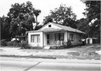
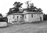
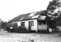
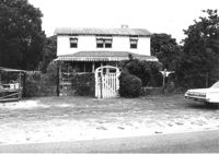
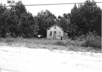
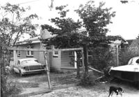
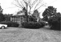
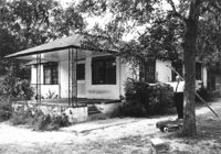
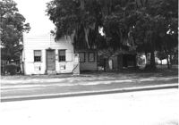
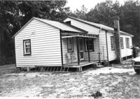
House on site affected by the widening of U.S. Route 17. Presumably located in Mount Pleasant or vicinity. Surveyor notations on back of photo: "Dkt.: 10.597. Property owner: Julia B. Simmons. Tract: 54. Station: 301+00 Lt. Date: Sept. 17, 1968." [See collection description for explanation of surveyor notations.]
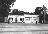
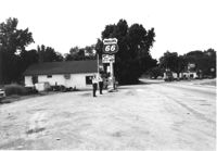
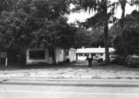
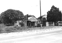
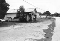
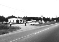
Humble gas station / Esso gas station on site affected by the widening of U.S. Route 17. Ed Cummings, proprietor. Presumably located in Mount Pleasant or vicinity. Surveyor notations on back of photo: "Dkt.: 10.597. Property owner: Edward Cummings. Tract: 37. Station: 285+20 Lt. Date: Sept. 17, 1968." [See collection description for explanation of surveyor notations.]
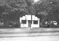
Building on site affected by the widening of U.S. Route 17. Front facade has stepped parapet. Appears to have previously been a business. Presumably located in Mount Pleasant or vicinity. Surveyor notations on back of photo: "Dkt.: 10.597. Property owner: Leon Burns, et al. Tract: 5. Station: 265± Lt. looking south. Date: Sept. 17, 1968." [See collection description for explanation of surveyor notations.]
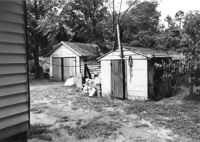
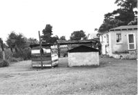
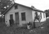
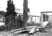
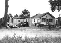
Sheds behind house on site affected by the widening of U.S. Route 17. Presumably located in Mount Pleasant or vicinity. Surveyor notations on back of photo: "Dkt.: 10.597. Property owner: Julia B. Simmons. Tract: 54. Station: 301±30 Lt. Date: Sept. 17, 1968." [See collection description for explanation of surveyor notations.]
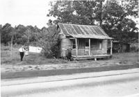
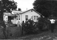
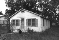
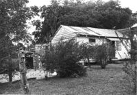
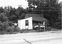
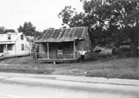
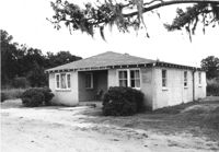
House in dilapidated condition on site affected by the widening of U.S. Route 17. Presumably located in Mount Pleasant or vicinity. Surveyor notations on back of photo: "Dkt.: 10.597. Property owner: Isaac Snype, Estate. Tract: 39. Station: 288+10 Lt. Date: Sept. 17, 1968." [See collection description for explanation of surveyor notations.]
Phillips 66 gas station on site affected by the widening of U.S. Route 17. Gulf gas station in background. Presumably located in southern Charleston County. Surveyor notations on back of photo: "Dkt.: 10.600. Property owner: Nora Bishop Carmichael. Tract: 18. Station: 608±40 Lt. Date: Sept. 18, 1968." [See collection description for explanation of surveyor notations.]
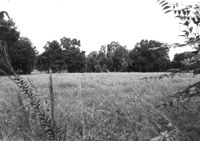
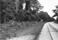
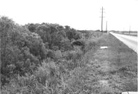
Lot on site affected by the widening of U.S. Route 17. Presumably located in southern Charleston County. Surveyor notations on back of photo: "Dkt.: 10.600. Property owner: John D. Postell, Sr., Estate. Tract: 12. Station: 605± Rt. Date: Sept. 18, 1968." [See collection description for explanation of surveyor notations.]
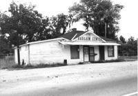
Building on site affected by the widening of U.S. Route 17. Appears to have previously been a store. Presumably located in Mount Pleasant or vicinity. Surveyor notations on back of photo: "Dkt.: 10.597. Property owner: Geo. G. Browder, Jr. Tract: 22. Station: 275+20 Lt. Date: Sept. 17, 1968." [See collection description for explanation of surveyor notations.]
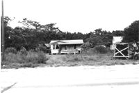
House and lot on site affected by the widening of U.S. Route 17. Small roadside stand on property. Presumably located in Mount Pleasant or vicinity. Surveyor notations on back of photo: "Dkt.: 10.597. Property owner: Dorothy R. Ayers, et al. Tract: 12-A213. Station: 259+50Rt. looking north. Date: Sept. 17, 1968." [See collection description for explanation of surveyor notations.]
Buildings on site affected by the widening of U.S. Route 17. Wagon Wheel Furniture in foreground. Presumably located in Mount Pleasant or vicinity. Surveyor notations on back of photo: "Dkt.: 10.597. Property owner: Erma B. Salvo. Tract: 18. Station: 268± Lt. Date: Sept. 17, 1968." [See collection description for explanation of surveyor notations.]
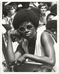
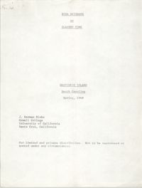
Typescript essay by J. Herman Blake entitled, "Rosa Brisbane on Slavery Time" consisting of an interview with Rosa Brisbane, Daufuskie Island native whose parents were slave.
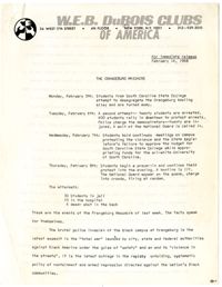
A press release from the national office of the W.E.B. DuBois Clubs of America describing the events of the Orangeburg Massacre and its misrepresentation in the media. This release was to be distributed to local chapters of the DuBois Clubs to educate its members on the events of the Orangeburg Massacre, to suggest ways for them to get involved in promoting awareness, and to advocate for mass mobilization against racial repression.
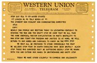
Western Union Telegram sent by members of the Kentucky Conference on the War and the Draft relating the shared struggle of the Freedom Movement and the Anti-war movement. The Kentucky Conference was planned to occur on February 11, 1968 and was expected to attract as many as 500 people.
A fact sheet released by Atlanta University relating the events of the Orangeburg Massacre and advocating dressing in black on February 15th, 1968 to commemorate the lives of the three men slain on the day of their funerals.
House in dilapidated condition and sweetgrass basket stand on site affected by the widening of U.S. Route 17. Presumably located in Mount Pleasant or vicinity. Surveyor notations on back of photo: "Dkt.: 10.597. Property owner: Linda Huger, Estate. Tract: 84 & 85. Station: 448± Lt. Date: Sept. 17, 1968." [See collection description for explanation of surveyor notations.]
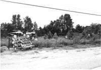
Lot with sweetgrass basket stand, on site affected by the widening of U.S. Route 17. Presumably located in Mount Pleasant or vicinity. Surveyor notations on back of photo: "Dkt.: 10.597. Property owner: Mary B. McConnell. Tract: 81. Station: 440±30 Rt. Date: Sept. 17, 1968." [See collection description for explanation of surveyor notations.]
Rear view of house and sheds on site affected by the widening of U.S. Route 17. Presumably located in Mount Pleasant or vicinity. Surveyor notations on back of photo: "Dkt.: 10.597. Property owner: John Gailliard. Tract: 102. Station: 466±40 Rt. Date: Sept. 17, 1968." [See collection description for explanation of surveyor notations.]
House (corner view, rear) on site affected by the widening of U.S. Route 17. Presumably located in Mount Pleasant or vicinity. Surveyor notations on back of photo: "Dkt.: 10.597. Property owner: John Gailliard. Tract: 102. Station: 466±40 Rt. Date: Sept. 17, 1968." [See collection description for explanation of surveyor notations.]
House (corner view, rear) on site affected by the widening of U.S. Route 17. Presumably located in Mount Pleasant or vicinity. Surveyor notations on back of photo: "Dkt.: 10.597. Property owner: Charles Dingle. Tract: 98. Station 462±50 Rt. Date: Sept. 17, 1968." [See collection description for explanation of surveyor notations.]
House (rear view) on site affected by the widening of U.S. Route 17. Presumably located in Mount Pleasant or vicinity. Surveyor notations on back of photo: "Dkt.: 10.597. Property owner: George Frederick, Estate. Tract: 91. Station: 456±20 Rt. Date: Sept. 17, 1968." [See collection description for explanation of surveyor notations.]
House on site affected by the widening of U.S. Route 17. Presumably located in Mount Pleasant or vicinity. Surveyor notations on back of photo: "Dkt.: 10.597. Property owner: Prince and Wilhelmina Gilliard. Tract: 92. Station: 457±10 Rt. Date: Sept. 17, 1968." [See collection description for explanation of surveyor notations.]
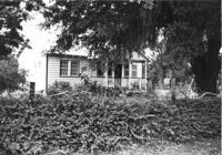
House (rear view) on site affected by the widening of U.S. Route 17. Presumably located in Mount Pleasant or vicinity. Surveyor notations on back of photo: "Dkt.: 10.597. Property owner: Irene Foreman. Tract: 78. Station: 441+50 Lt. Date: Sept. 17, 1968." [See collection description for explanation of surveyor notations.]
House on site affected by the widening of U.S. Route 17. Presumably located in Mount Pleasant or vicinity. Surveyor notations on back of photo: "Dkt.: 10.597. Property owner: George Frederick, Estate. Tract: 91. Station: 456±20 Rt. Date: Sept. 17, 1968." [See collection description for explanation of surveyor notations.]
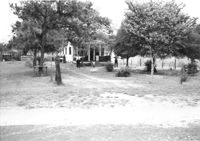
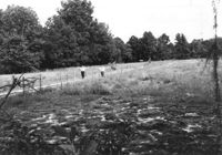
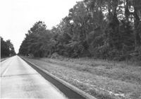
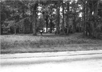
Lot on site affected by the widening of U.S. Route 17. Presumably located in Mount Pleasant or vicinity. Surveyor notations on back of photo: "Dkt.: 10.597. Property owner: Alexandera E. Stone, Est. Tract: 55. Station: 302± Lt. looking east. Date: Sept. 17, 1968." [See collection description for explanation of surveyor notations.]
The Twin Lanterns Antiques, Gifts, Used Furniture shop, on site affected by the widening of U.S. Route 17. Neighboring fireworks store in background. Presumably located in Mount Pleasant or vicinity. Surveyor notations on back of photo: "Dkt.: 10.597. Property owner: Oliver H. Smith. Tract: 56. Station: 297+70 Rt. Date: Sept. 17, 1968." [See collection description for explanation of surveyor notations.]
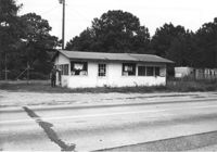
Bargain Center Supermarket on site affected by the widening of U.S. Route 17. Presumably located in southern Charleston County. Surveyor notations on back of photo: "Dkt.: 10.600. Property owner: Vernon A. Ellis. Tract: 3. Station: 512± - 514± Rt. Date: Sept. 18, 1968." [See collection description for explanation of surveyor notations.]
Shed and/or garage on site affected by the widening of U.S. Route 17. Presumably located in southern Charleston County. Surveyor notations on back of photo: "Dkt.: 10.600. Property owner: Vernon A. Ellis. Tract: 3. Station: 512± - 514± Rt. Date: Sept. 18, 1968." [See collection description for explanation of surveyor notations.]
House and sweetgrass basket stand on site affected by the widening of U.S. Route 17. Presumably located in Mount Pleasant or vicinity. Surveyor notations on back of photo: "Dkt.: 10.597. Property owner: Linda Huger, Estate. Tract 84 & 85. Station: 448±70 Lt. Date: Sept. 17, 1968." [See collection description for explanation of surveyor notations.]
House in dilapidated condition and structure on site affected by the widening of U.S. Route 17. Presumably located in Mount Pleasant or vicinity. Surveyor notations on back of photo: "Dkt.: 10.597. Property owner: Charles & Eugene German. Tract: 88. Station: 449±50 Rt. Date: Sept. 17, 1968." [See collection description for explanation of surveyor notations.]
House in dilapidated condition and lot on site affected by the widening of U.S. Route 17. Presumably located in Mount Pleasant or vicinity. Surveyor notations on back of photo: "Dkt.: 10.597. Property owner: Mary B. McConnell. Tract: 82. Station: 442± Rt. Date: Sept. 17, 1968." [See collection description for explanation of surveyor notations.]
House on site affected by the widening of U.S. Route 17. Presumably located in southern Charleston County. Surveyor notations on back of photo: "Dkt.: 10.600. Property owner: Malsey Lawrence, Estate. Tract: 4. Station: 516±80 Rt. Date: Sept. 18, 1968." [See collection description for explanation of surveyor notations.]
Rear view of house and structure under construction on site affected by the widening of U.S. Route 17. Presumably located in Mount Pleasant or vicinity. Surveyor notations on back of photo: "Dkt.: 10.597. Property owner: James Gailliard. Tract: 101. Station: 465±60 Rt. Date: Sept. 17, 1968." [See collection description for explanation of surveyor notations.]
House (rear view, partially obscured by bushes) on site affected by the widening of U.S. Route 17. Presumably located in Mount Pleasant or vicinity. Surveyor notations on back of photo: "Dkt.: 10.597. Property owner: Charles Dingle. Tract: 98. Station 461±50 Rt. Date: Sept. 17, 1968." [See collection description for explanation of surveyor notations.]
House and lot on site affected by the widening of U.S. Route 17. Wire fence in foreground. Presumably located in Mount Pleasant or vicinity. Surveyor notations on back of photo: "Dkt.: 10.597. Property owner: James Gailliard. Tract: 101. Station: 465±60 Rt. Date: Sept. 17, 1968." [See collection description for explanation of surveyor notations.]
House and structure under construction on site affected by the widening of U.S. Route 17. Presumably located in Mount Pleasant or vicinity. Surveyor notations on back of photo: "Dkt.: 10.597. Property owner: Arthur Gailliard. Tract: 100. Station: 465± Rt. Date: Sept. 17, 1968." [See collection description for explanation of surveyor notations.]
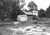
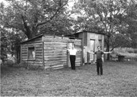
Sheds on site affected by the widening of U.S. Route 17. Presumably located in Mount Pleasant or vicinity. Surveyor notations on back of photo: "Dkt.: 10.597. Property owner: F. Gregorie, Estate. Tract: 93. Station: 460± Rt. Date: Sept. 17, 1968." [See collection description for explanation of surveyor notations.]
House and lot on site affected by the widening of U.S. Route 17. Presumably located in Mount Pleasant or vicinity. Surveyor notations on back of photo: "Dkt.: 10.597. Property owner: Cleveland German. Tract: 89. Station: 450±25 Rt. Date: Sept. 17, 1968." [See collection description for explanation of surveyor notations.]
Lot on site affected by the widening of U.S. Route 17. Presumably located in southern Charleston County. Surveyor notations on back of photo: "Dkt.: 10.600. Property owner: John D. Postell, Jr. Tract: 15. Station: 620± Rt. Date: Sept. 18, 1968." [See collection description for explanation of surveyor notations.]
Lot on site affected by the widening of U.S. Route 17. Presumably located in southern Charleston County. Surveyor notations on back of photo: "Dkt.: 10.600. Property owner: Thomas H. Lemacks. Tract: 19. Station: 611± Lt. Date: Sept. 18, 1968." [See collection description for explanation of surveyor notations.]
Lot on site affected by the widening of U.S. Route 17. Presumably located in southern Charleston County. Surveyor notations on back of photo: "Dkt.: 10.600. Property owner: Fred Stewart. Tract: 1-B. Station: 509± Lt. Date: Sept. 18, 1968." [See collection description for explanation of surveyor notations.]
Lot on site affected by the widening of U.S. Route 17. Presumably located in southern Charleston County. Surveyor notations on back of photo: "Dkt.: 10.600. Property owner: Johnnie Ford. Tract: 1-C. Station: 505± Lt. Date: Sept. 18, 1968." [See collection description for explanation of surveyor notations.]
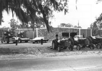
Building on site affected by the widening of U.S. Route 17. Tractors and other machinery on lot. Appears to be a dealer of equipment. Presumably located in southern Charleston County. Surveyor notations on back of photo: "Dkt.: 10.600. Property owner: Arthur J. Stark. Tract: 1. Station: 515± - 520± Lt. Date: Sept. 18, 1968." [See collection description for explanation of surveyor notations.]
House on site affected by the widening of U.S. Route 17. Presumably located in southern Charleston County. Surveyor notations on back of photo: "Dkt.: 10.600. Property owner: R. Arnold Postell. Tract: 14. Station: 610±35 Rt. Date: Sept. 18, 1968." [See collection description for explanation of surveyor notations.]
Lot on site affected by the widening of U.S. Route 17. Presumably located in southern Charleston County. Surveyor notations on back of photo: "Dkt.: 10.600. Property owner: McLeod Lumber Co. & E.W. Durant. Tract: 9. Station: 585± Rt. Date: Sept. 18, 1968." [See collection description for explanation of surveyor notations.]
Lot on site affected by the widening of U.S. Route 17. Presumably located in southern Charleston County. Surveyor notations on back of photo: "Dkt.: 10.600. Property owner: Lula A. Dickenson, et al. Tract: 5. Station: 525± Lt. & Rt. Date: Sept. 18, 1968." [See collection description for explanation of surveyor notations.]
Lot on site affected by the widening of U.S. Route 17. Presumably located in southern Charleston County. Surveyor notations on back of photo: "Dkt.: 10.600. Property owner: R. Maude P. Postell, Estate. Tract: 13. Station: 613± Lt. Date: Sept. 18, 1968." [See collection description for explanation of surveyor notations.]
Lot on site affected by the widening of U.S. Route 17. Presumably located in southern Charleston County. Surveyor notations on back of photo: "Dkt.: 10.600. Property owner: Dr. T.W. Messervy. Tract: 7. Station: 545± Lt. Date: Sept. 18, 1968." [See collection description for explanation of surveyor notations.]
Lot on site affected by the widening of U.S. Route 17. Presumably located in southern Charleston County. Surveyor notations on back of photo: "Dkt.: 10.600. Property owner: Michah Jenkins. Tract: 6. Station: 546± Rt. Date: Sept. 18, 1968." [See collection description for explanation of surveyor notations.]
House on site affected by the widening of U.S. Route 17. Presumably located in Mount Pleasant or vicinity. Surveyor notations on back of photo: "Dkt.: 10.597. Property owner: George Scott. Tract: 76. Station: 438+50 Lt. Date: Sept. 17, 1968." [See collection description for explanation of surveyor notations.]
House on site affected by the widening of U.S. Route 17. Presumably located in Mount Pleasant or vicinity. Surveyor notations on back of photo: "Dkt.: 10.597. Property owner: Irene Foreman. Tract: 78. Station: 441+50 Lt. Date: Sept. 17, 1968." [See collection description for explanation of surveyor notations.]
House on site affected by the widening of U.S. Route 17. Presumably located in Mount Pleasant or vicinity. Surveyor notations on back of photo: "Dkt.: 10.597. Property owner: George Scott. Tract: 76. Station: 438+50 Lt. Date: Sept. 17, 1968." [See collection description for explanation of surveyor notations.]
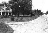
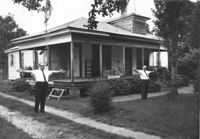
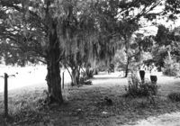
Entry to Boone Hall Plantation, on site affected by the widening of U.S. Route 17. Presumably located in Mount Pleasant or vicinity. Surveyor notations on back of photo: "Dkt.: 10.597. Property owner: Mrs. Nancy T. McRae. Tract: 64. Station: 384±50 Lt. Date: Sept. 17, 1968." [See collection description for explanation of surveyor notations.]
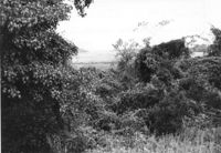
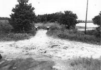
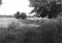
Lot on site affected by the widening of U.S. Route 17. Small house in background, obscured by trees. Presumably located in Mount Pleasant or vicinity. Surveyor notations on back of photo: "Dkt.: 10.597. Property owner: Mrs. Nancy T. McRae. Tract: 64. Station: 409+40 Lt. Date: Sept. 17, 1968." [See collection description for explanation of surveyor notations.]
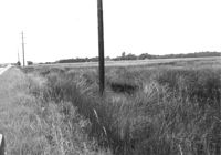
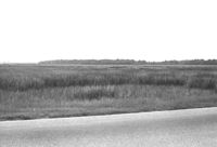
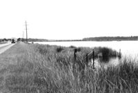
Lot and marsh land on site affected by the widening of U.S. Route 17. Presumably located in southern Charleston County. Surveyor notations on back of photo: "Dkt.: 10.600. Property owner: The Summerville Land Corp., Inc. Tract: 8. Station: 570± Rt. Date: Sept. 18, 1968." [See collection description for explanation of surveyor notations.]
Lot on site affected by the widening of U.S. Route 17. Presumably located in Mount Pleasant or vicinity. Surveyor notations on back of photo: "Dkt.: 10.597. Property owner: O.D. Hamlin. Tract: 110. Station: 479± - 487± Rt. Date: Sept. 17, 1968." [See collection description for explanation of surveyor notations.]
Lot on site affected by the widening of U.S. Route 17. Presumably located in southern Charleston County. Surveyor notations on back of photo: "Dkt.: 10.600. Property owner: The Summerville Land Corp., Inc. Tract: 8. Station: 570± Rt. Date: Sept. 18, 1968." [See collection description for explanation of surveyor notations.]
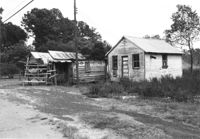
Gas station on site affected by the widening of U.S. Route 17. Presumably located in Mount Pleasant or vicinity. Surveyor notations on back of photo: "Dkt.: 10.597. Property owner: Charles Dingle. Tract: 98. Station 461±50 Rt. Date: Sept. 17, 1968." [See collection description for explanation of surveyor notations.]
Texaco gas station on site affected by the widening of U.S. Route 17. Presumably located in southern Charleston County. Surveyor notations on back of photo: "Dkt.: 10.600. Property owner: Harold Dukes. Tract: 16-B. Station: 628± Lt. Date: Sept. 18, 1968." [See collection description for explanation of surveyor notations.]
Lot and house (in background) on site affected by the widening of U.S. Route 17. Presumably located in Mount Pleasant or vicinity. Surveyor notations on back of photo: "Dkt.: 10.597. Property owner: Mary B. McConnell. Tract: 71. Station: 427+ Lt. Date: Sept. 17, 1968." [See collection description for explanation of surveyor notations.]
House (rear view) on site affected by the widening of U.S. Route 17. Presumably located in Mount Pleasant or vicinity. Surveyor notations on back of photo: "Dkt.: 10.597. Property owner: Julia B. Simmons. Tract: 54. Station: 301+00 Lt. Date: Sept. 17, 1968." [See collection description for explanation of surveyor notations.]
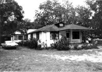
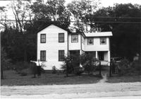
House on site affected by the widening of U.S. Route 17. Presumably located in Mount Pleasant or vicinity. Surveyor notations on back of photo: "Dkt.: 10.597. Property owner: Fay Collington, Est. Tract: 46. Station: 285+50 Rt. Date: Sept. 17, 1968." [See collection description for explanation of surveyor notations.]
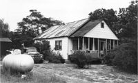
House on site affected by the widening of U.S. Route 17. Presumably located in Mount Pleasant or vicinity. Surveyor notations on back of photo: "Dkt.: 10.597. Property owner: Edward Cummings. Tract: 45. Station: 284+50 Rt. Date: Sept. 17, 1968." [See collection description for explanation of surveyor notations.]
House in dilapidated condition on site affected by the widening of U.S. Route 17. Presumably located in Mount Pleasant or vicinity. Surveyor notations on back of photo: "Dkt.: 10.597. Property owner: Isaac Snype, Estate. Tract: 39. Station: 288+10 Lt. Date: Sept. 17, 1968." [See collection description for explanation of surveyor notations.]
House on site affected by the widening of U.S. Route 17. Sweetgrass basket stand at right. Presumably located in Mount Pleasant or vicinity. Surveyor notations on back of photo: "Dkt.: 10.597. Property owner: Will Jones. Tract: 77-A. Station: 440+00 Lt. Date: Sept. 17, 1968." [See collection description for explanation of surveyor notations.]
Lot on site affected by the widening of U.S. Route 17. Presumably located in southern Charleston County. Surveyor notations on back of photo: "Dkt.: 10.600. Property owner: R. Arnold Postell. Tract: 16. Station: 630± Rt. Date: Sept. 18, 1968." [See collection description for explanation of surveyor notations.]
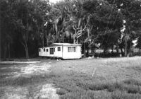
Mobile home on site affected by the widening of U.S. Route 17. Presumably located in southern Charleston County. Surveyor notations on back of photo: "Dkt.: 10.600. Property owner: John D. Postell, Jr. Tract: 15. Station: 623± Rt. Date: Sept. 18, 1968." [See collection description for explanation of surveyor notations.]
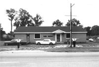
Farm Bureau building, on site affected by the widening of U.S. Route 17. Presumably located in southern Charleston County. Surveyor notations on back of photo: "Dkt.: 10.600. Property owner: Charleston County Farm Bureau. Tract: 2. Station: 507±30 Lt. Date: Sept. 18, 1968." [See collection description for explanation of surveyor notations.]
House on site affected by the widening of U.S. Route 17. Presumably located in Mount Pleasant or vicinity. Surveyor notations on back of photo: "Dkt.: 10.597. Property owner: John Gailliard. Tract: 102. Station: 466±40 Rt. Date: Sept. 17, 1968." [See collection description for explanation of surveyor notations.]
House on site affected by the widening of U.S. Route 17. Presumably located in Mount Pleasant or vicinity. Surveyor notations on back of photo: "Dkt.: 10.597. Property owner: Charles Dingle. Tract: 98. Station 462±50 Rt. Date: Sept. 17, 1968." [See collection description for explanation of surveyor notations.]
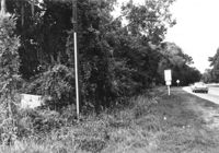
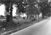
Lot on site affected by the widening of U.S. Route 17. Sign posted to tree: This land cleared by Atlantic Land Corp. Presumably located in southern Charleston County. Surveyor notations on back of photo: "Dkt.: 10.600. Property owner: Arthur J. Stark. Tract: 1. Station: 515± Lt. Date: Sept. 18, 1968." [See collection description for explanation of surveyor notations.]