U.S. Department of Health, Education, and Welfare publication entitled, "Guidelines: Special Programs for Educationally Deprived Children, Section II. Design and Evaluation Projects," discussing Statutory Requirements Under Section 205(a) of Title I and other factors in project planning and evaluation.
Scrapbook about the celebration of National Library Week, 1965 at the Colleton County Memorial Library. Scrapbook includes list of Board members, essay contest winners and prizes, descriptions of activities, and newspaper clippings from The Press and Standard.
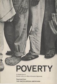
Pamphlet reprinted from the Encyclopedia Americana entitled, "Poverty," written by Sargent Shriver, Director of the U.S. Office of Economic Opportunity.
"Written by Dr. Martin Luther King, Jr. and Reverend Andrew J. Young, requesting leadership training for Black ministers of thirty urban areas and citizenship training for neighborhood leaders of five major cities; and catalog regarding Ford Foundation travel and study grants."
Essay entitled, "The Culture of Poverty," written by Oscar Lewis, used as course material for Consumers' Cooperatives Instructor, instructed by Father Albert Joseph McKnight, C. S. Sp.
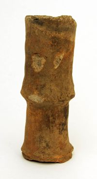
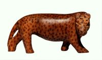
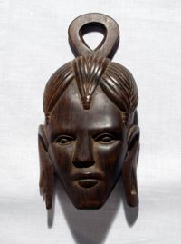
End of a pottery tuyere used in a kiln; a tuyere is a tube through which air or oxygen is blown into a blast furnace, a ceramic blow tube to keep the furnace hot; origin Uganda.
Transcriptions of Rabbi Padoll’s typewritten and handwritten sermons and addresses from his various rabbinates, including Charleston’s Kahal Kadosh Beth Elohim. A civil rights advocate, Padoll discusses ongoing struggles for social justice, contemporary events such as the assassination of Robert F. Kennedy, and parables related to the Sabbath and holiday celebrations. Padoll stored his sermons in nine binders, and the transcriptions reflect this original order. Burton L. Padoll (1929-2004), was born to Leah and Charles Padoll in Canton, Ohio. Padoll attended the Hebrew Union College in Cincinnati, Ohio, where he was ordained in 1957 and received an honorary Doctorate of Divinity in 1982. After his ordination, Padoll served as assistant rabbi in Brookline, Massachusetts. In 1961, Padoll took a position as rabbi of Kahal Kadosh Beth Elohim (KKBE) in Charleston, South Carolina, where he served for six years. During this time, Padoll strongly advocated for civil rights and criticized Charleston's Jewish community for their failure to aid the struggle for racial equality. After leaving Charleston in 1967, Padoll moved to Peabody, Massachusetts, where he became the rabbi of Temple Beth Shalom in 1969 until his retirement in 1989. Padoll lived in Mount Jackson, Virginia, until his death in 2004.
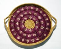
Yellow, violet, and natural coiled raffia basket with two handles; tray-shaped, repetitive geometric decorations in natural raffia within violet bands, edge is three rows of tightly woven material with handles on either side, plain underside; origin Uganda.
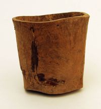
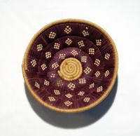
Yellow, violet, and natural coiled raffia basket; repetitive geometric decorations in natural raffia within violet bands, edge is three rows of tightly woven material, plain underside; origin Uganda.
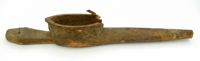
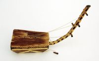
Five string harp with a wooden body, animal skin across top, cord strings; very decorated with geometric pattern wood-burned into body, arm has giraffe-like spots; origin Uganda.
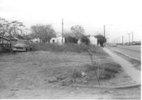
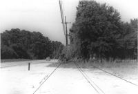
Lot on Spruill Avenue, on site affected by the construction of Interstate 26 (I-26). Houses in background. Surveyor notations on back of photo: "Dkt.: 10.490. Property owner: E.C. Brown. Tract: 28-A. Station: 51+50 Rt. (Spruill Ave.). Date: November 4, 1965. General view of land located in radius at intersection of Spruill Ave. and I-26. Line 'A'." [See collection description for explanation of surveyor notations.]
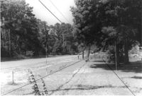
House on Spruill Avenue on site affected by the construction of Interstate 26 (I-26). [Intersection of Hugo Avenue.] Surveyor notations on back of photo: "Dkt.: 10.490. Property owner: Julia M. Pritchard. Tract: 28-B. Station: 48+80 Rt. (Spruill Ave.) Date: November 4, 1965. Range poles on new R/W. Building partially in R/W." [See collection description for explanation of surveyor notations.]
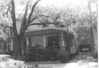
Lot and house (side view) on site affected by the widening of U.S. Route 17. Posted sign says: Edna's Ceramic Chop: Greenware, supplies, firing, lessons. Presumably located in Mount Pleasant or vicinity. Surveyor notations on back of photo: "Dkt.: 10.439. Property owner: Doretha B. Chavis. Tract: 15. Station: 224+51 to 225+51 Lt. Date: Jul. 22, 1965. Proximity." [See collection description for explanation of surveyor notations.]
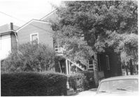
House (side view, rear) on site affected by the construction of Interstate 26 (I-26). Address: 1 Carolina Street. Surveyor notations on back of photo: "Dkt.: 10.517. Property owner: Ella W. Britton. Tract: 130. Station: 21+30 Lt. and Rt. (Line "1"). Date: November 4, 1965. Side and rear view of residence and lot, all entirely in R/W." [See collection description for explanation of surveyor notations.]
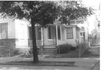
House on site affected by the construction of Interstate 26 (I-26). Address: 3 Carolina Street. Surveyor notations on back of photo: "Dkt.: 10.517. Property owner: Benjamin J. Finklea. Tract: 129. Station: 21+65 Rt. (Line "1"). Date: November 4, 1965. Subject residence and lot entirely in R/W." [See collection description for explanation of surveyor notations.]
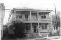
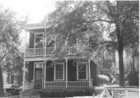
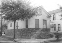
House on site affected by the construction of Interstate 26 (I-26). Address: 693 King Street. Surveyor notations on back of photo: "Dkt.: 10.517. Property owner: Rose Sokol. Tract: 132. Station: 19+20 Lt. and Rt. (Line "1"). Date: November 4, 1965. Front view of subject residence and lot, all in R/W." [See collection description for explanation of surveyor notations.]
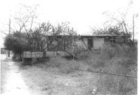
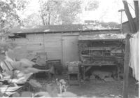
Shed behind house on site affected by the construction of Interstate 26 (I-26). Address: 5 Carolina Street. Surveyor notations on back of photo: "Dkt.: 10.517. Property owner: I.S. Keith Ellsworth, Sr. Tract: 128. Station: 22+50 Rt. (Line "1"). Date: November 4, 1965. Backyard with shed, entirely in R/W." [See collection description for explanation of surveyor notations.]
House on site affected by the construction of Interstate 26 (I-26). Address: 310 St. Philip Street. Surveyor notations on back of photo: "Dkt.: 10.517. Property owner: Benjamin W. Steed. Tract: 131. Station: 20+65 Lt. and Rt. (Line "1"). Date: November 4, 1965. Side view of residence entirely in R/W." [See collection description for explanation of surveyor notations.]
House on site affected by the construction of Interstate 26 (I-26). Address: 1 Carolina Street. Surveyor notations on back of photo: "Dkt.: 10.517. Property owner: Ella W. Britton. Tract: 130. Station: 21+30 Lt. and Rt. (Line "1"). Date: November 4, 1965. Front view of residence and lot entirely in R/W." [See collection description for explanation of surveyor notations.]
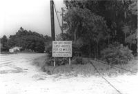
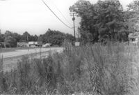
Lot on site affected by the widening of U.S. Route 17. Posted sign says: You just passed last motel for 50 miles, Mt. Pleasant Motel, ¼ mile back. Presumably located in Mount Pleasant or vicinity. Surveyor notations on back of photo: "Dkt.: 10.439. Property owner: Charleston County Public Works. Tract: 12. Station: 239+45 to 243+73 Rt. Date: Jul. 22, 1965. Range poles on 50' R/W & fence on 33' R/W - Cond." [See collection description for explanation of surveyor notations.]
Lot on site affected by the widening of U.S. Route 17. Posted sign says: Speed checked by radar. Presumably located in Mount Pleasant or vicinity. Surveyor notations on back of photo: "Dkt.: 10.439. Property owner: Francis F. Coleman, et al. Tract: 13. Station: 245+50 Rt. Date: Jul. 22, 1965. Range poles on 33' & 50' R/W showing house (portion)." [See collection description for explanation of surveyor notations.]
Lot on site affected by the widening of U.S. Route 17. Presumably located in Mount Pleasant or vicinity. Surveyor notations on back of photo: "Dkt.: 10.439. Property owner: Charleston County Public Works. Tract: 12. Station: 239+45 to 243+73 Rt. Date: Jul. 22, 1965. Looking from the east at range poles on 50' R/W & fence on 33' R/W - Cond." [See collection description for explanation of surveyor notations.]
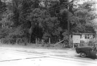
Lot on site affected by the widening of U.S. Route 17. Presumably located in Mount Pleasant or vicinity. Surveyor notations on back of photo: "Dkt.: 10.439. Property owner: Charleston Oil Co. Tract: 11. Station: 237+26 to 239+45 Rt. Date: Jul. 22, 1965. Range poles on 33' & 50' R/W - Cond." [See collection description for explanation of surveyor notations.]
House on site affected by the construction of Interstate 26 (I-26). Address: 310 St. Philip Street. View of street corner; corner of St. Philip Street and Carolina Street. Surveyor notations on back of photo: "Dkt.: 10.517. Property owner: Benjamin W. Steed. Tract: 131. Station: 20+50 Lt. and Rt. (Line "1"). Date: November 4, 1965. Side view of residence in R/W." [See collection description for explanation of surveyor notations.]
Lot on site affected by the widening of U.S. Route 17. Posted sign says: You just passed last motel for 50 miles, Mt. Pleasant Motel, ¼ mile back. Portion of house visible. Presumably located in Mount Pleasant or vicinity. Surveyor notations on back of photo: "Dkt.: 10.439. Property owner: Charleston County Public Works. Tract: 12. Station: 240+00 Rt. Date: Jul. 22, 1965. Looking from west at range poles on 50' R/W & fence on 33' R/W - Cond." [See collection description for explanation of surveyor notations.]
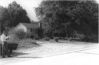
Roadside lot on site affected by the widening of U.S. Route 17. Presumably located in Mount Pleasant or vicinity. Surveyor notations on back of photo: "Dkt.: 10.439. Property owner: Louise S. Carter. Tract: 3. Station: 230±50 Rt. Date: Jul. 22, 1965. Looking NE from Carter Ave. at range poles on 33' & 50' R/Ws - Cond." [See collection description for explanation of surveyor notations.]
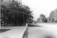
Roadside lot on site affected by the widening of U.S. Route 17. Presumably located in Mount Pleasant or vicinity. Surveyor notations on back of photo: "Dkt.: 10.439. Property owner: Louise S. Carter. Tract: 3. Station: 229±50 Rt. Date: Jul. 22, 1965. Looking NE at range on 33' R/W & 50' R/W - Cond." [See collection description for explanation of surveyor notations.]
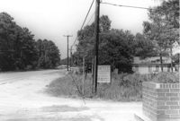
Lot on site affected by the widening of U.S. Route 17. Presumably located in Mount Pleasant or vicinity. Surveyor notations on back of photo: "Dkt.: 10.439. Property owner: Samuel D. Causey. Tract: 6. Station: 233±00 Rt. Date: Jul. 22, 1965. Range poles on 33' & 50' R/W - Cond." [See collection description for explanation of surveyor notations.]
Lot and building on site affected by the widening of U.S. Route 17. Billboard for Busch Bavarian [beer] in background. Presumably located in Mount Pleasant or vicinity. Surveyor notations on back of photo: "Dkt.: 10.439. Property owner: A.J. Ashley. Tract: 19. Station: 241+92 Lt. Date: Jul. 22, 1965. Range poles on new R/W & man & range poles on pres. 33' R/W. Portion of bldg within R/W." [See collection description for explanation of surveyor notations.]
Lot and building on site affected by the widening of U.S. Route 17. Billboard for Busch Bavarian [beer] in background. Presumably located in Mount Pleasant or vicinity. Surveyor notations on back of photo: "Dkt.: 10.439. Property owner: A.J. Ashley. Tract: 19. Station: 241+92 Lt. Date: Jul. 22, 1965. Range poles on new R/W & man & range poles on pres. 33' R/W. Portion of bldg within R/W." [See collection description for explanation of surveyor notations.]
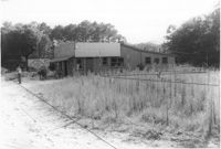
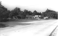
Lot and buildings on site affected by the widening of U.S. Route 17. Billboard for Busch Bavarian [beer] in background. Presumably located in Mount Pleasant or vicinity. Surveyor notations on back of photo: "Dkt.: 10.439. Property owner: A.J. Ashley. Tract: 19. Station: 238+85 to 242+45 Lt. Date: Jul. 22, 1965. Range poles on pres. & 75' R/W - Cond. 2 frame bldg." [See collection description for explanation of surveyor notations.]
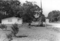
House on site affected by the widening of U.S. Route 17. Presumably located in Mount Pleasant or vicinity. Surveyor notations on back of photo: "Dkt.: 10.439. Property owner: A.J. Ashley. Tract: 20. Station: 242+85 Lt. Date: Jul. 22, 1965. Proximity." [See collection description for explanation of surveyor notations.]
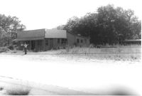
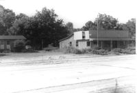
Buildings on site affected by the widening of U.S. Route 17. Presumably located in Mount Pleasant or vicinity. Surveyor notations on back of photo: "Dkt.: 10.439. Property owner: A.J. Ashley. Tract: 19. Station: 241+00 Lt. Date: Jul. 22, 1965. Range poles on pres. & 75' R/W - front of both bldg." [See collection description for explanation of surveyor notations.]
Lot in front of Mt. Pleasant Motel, on site affected by the widening of U.S. Route 17. Presumably located in Mount Pleasant or vicinity. Surveyor notations on back of photo: "Dkt.: 10.439. Property owner: George A. Kaiser, et al. Tract: 16. Station: 225+51 to 228+52 Lt. Date: Jul. 22, 1965. Taken from west side showing range poles on 50' R/W & brick columns on 33' R/W - Cond." [See collection description for explanation of surveyor notations.]