Page 114 of the City Engineer's Plat Book with elven plats. Plat 1 features lots located at the corner of King Street and Queen Street. Plat 2 shows a strip of land on the west side of King Street. Plat 3 shows lots along King Street. Plat 4 shows lots located near the intersection of Savage Street and Tradd Street. Plat 5 shows lots located on King Street. Plat 6 shows lots located near the intersection of King Street and Queen Street. Plat 7 shows lots located on King Street. Plat 8 shows a lot located on King Street. Plat 9 shows lots located near the intersection of South Bay Street and Legare Street. Plat 10 shows a lot on King Street. Plat 11 shows lots located near the intersection of Council Street and Gibbes Street.
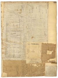
Page 123 of the City Engineer's Plat Book with six plats. Plat 1 shows lots and structures located on and near Calhoun Street, between Anson Street and Meeting Street. Plat 2 shows lots and structures located between East Bay Street and Cooper River. Plat 3 shows lots and buildings located near Meeting Street. Plat 4 shows lots near a road, and has a large hole in the middle. Plat 5 shows lots and buildings located on Beaufain Street. Plat 5 shows lots located near an intersection, and has several holes in the paper.
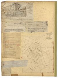
Page 144 of the City Engineer's Plat Book with five plats. Plat 1 shows lots on and near the Cooper River channel, near Boundary Street, Charlotte Street, Washington Street, and Alexander Street. Plat 1 also shows a creek and a stretch of marshland. Plat 2 shows lots located near the intersection of South Street and America Street. Plat 3 features structures located on the intersection of South Street and America Street. Plat 4 shows lots and structures located at the intersection of President Street and Cannon's Court. Plat 5 shows lots located between Drake Street, America Street, and Alexander Street.