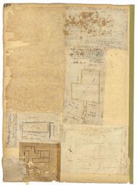
Page 120 of the City Engineer's Plat Book with five plats, labelled two through six. Plat 2 shows lots and buildings located near Cumberland Street, between Church Street and Philadelphia Street. Plat 3 shows lots located near the intersection Pinckney Street and Anson Street. Plat 4 shows lots and structures located on Hasell Street. Plat 5 shows lots and buildings along East Bay Street. Plat 6 shows lots and structures located between wharf street and the Cooper River.
Page 113 of the City Engineer's Plat Book with two plats. Plat 1 features "Shoal and Channel lots" located south of Tradd Street. Plat 1 also shows Gibbes Street, Council Street, two labels reading "ASHLEY RIVER EMBANKMENT," a line marking the edge of high land, a line marking the low water, and a line marking the edge of the channel. Plat 2 shows lots along New Street.
Page 115 of the City Engineer's Plat Book with four plats. Plat 1 shows land located near Broad Street, Short Street, Franklin Street, and Queen Street. Plat 2 shows lots and structures located on King Street. Plat 3 shows lots and structures located on Franklin Street. Plat 4 shows lots and structures located on Queen Street.
Page 99 of the City Engineer's Plat Book with four plats. Plat 1 shows land located near Meeting Street, between Williams Street and Semmes Street. Plat 1 also shows Nassau Street, Romney Street, some marshland, and New Market Creek. Plat 2 shows a lot with two structures located on Laurel Street. Plat 3 features lots located between Congress Street and Gadsden Street, near Pinckney Street. Plat 4 features lots located along Mount Street, between President Street and Payne Street.
Page 101 of the City Engineer's Plat Book with two plats. Plat 1 shows lots located between Washington Street and Wharf Street, and between Calhoun Street and Laurens Street. Plat 2 shows lots located near the intersection of Rutledge Avenue and Line Street, with several buildings labelled.
Page 98 of the City Engineer's Plat Book with three plats. Plat 1 shows lots between King Street and Meeting Street, including a stretch of railroad track and some marshlands. Plat 2 shows lots located near Rutledge Avenue. Plat 3 shows land located near a public road, showing a creek labelled "into Ashley," and stretches of marshland.
Page 94 of the City Engineer's Plat Book with two plats. Plat 1 shows lots and marshlands located near Meeting Street, and also shows King Street. Plat 2 features lots located between Meeting Street and a strip labelled "South Carolina R.R. Company." Plat 2 also shows Romney Street and Poinsett Street.
Page 95 of the City Engineer's Plat Book with four plats. Plat 1 shows lots located between Mount Street and Congress Street, and between Rutledge Street and Payne Street. Plat 2 features lots near Meeting Street, and shows a stretch of low ground. Plat 3 shows lots located near Mount Street, Payne Street, and Lowndes Court. Plat 4 shows lots located on Fishburne Street.
Page 96 of the City Engineer's Plat Book with two plats. Plat 1 shows lots located between King Street and Congress Street, and also shows Pinckney Street, Huger Street, and Moultrie Street. Plat 2 shows lots located near the intersection of Payne Street and Line Street, and also shows Kennedy Street.
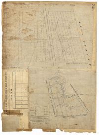
Page 40 of the City Engineer's Plat Book with three plats. Plat 1 shows lots located between Laurence Street and Boundary Street, and Anson Street and the Charleston Harbor on the Cooper River. Plat 1 also shows East Bay Street, Washington Street, Concord Street, several wharfs, marshland, and a label reading "Mazyck Borough." Plat 2 shows lots on Simmons Street, between King Street and a stretch of marshland. Plat 3 shows lots of land between New Street and Logan Street, and several buildings.