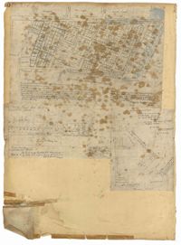
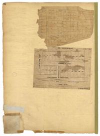
Page 101 of the City Engineer's Plat Book with two plats. Plat 1 shows lots located between Washington Street and Wharf Street, and between Calhoun Street and Laurens Street. Plat 2 shows lots located near the intersection of Rutledge Avenue and Line Street, with several buildings labelled.
Page 40 of the City Engineer's Plat Book with three plats. Plat 1 shows lots located between Laurence Street and Boundary Street, and Anson Street and the Charleston Harbor on the Cooper River. Plat 1 also shows East Bay Street, Washington Street, Concord Street, several wharfs, marshland, and a label reading "Mazyck Borough." Plat 2 shows lots on Simmons Street, between King Street and a stretch of marshland. Plat 3 shows lots of land between New Street and Logan Street, and several buildings.
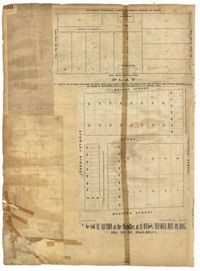
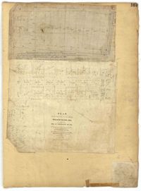
Page 160 of the City Engineer's Plat Book with four plats. Plat 1 shows a stretch of Mazyck Street, near its intersections with Queen Street and Short Street. Plat 2 shows lots and structures located on and near Reid Street, between Drake Street and Bay Street. Plat 4 shows lots and structures located between Nassau Street and Meeting Street, and between Stewart Street and Johnson Street.
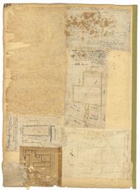
Page 120 of the City Engineer's Plat Book with five plats, labelled two through six. Plat 2 shows lots and buildings located near Cumberland Street, between Church Street and Philadelphia Street. Plat 3 shows lots located near the intersection Pinckney Street and Anson Street. Plat 4 shows lots and structures located on Hasell Street. Plat 5 shows lots and buildings along East Bay Street. Plat 6 shows lots and structures located between wharf street and the Cooper River.
A report from the mayor, city council, and various governmental departments of Charleston, South Carolina for the year 1884. The yearbook opens with an address from Mayor Courtenay followed by reports from various departments and an appendix.
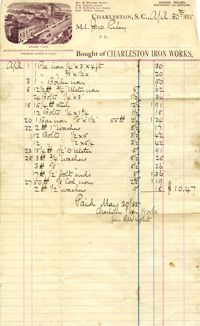
Papers include vouchers, receipts, and business letters (1884-1921) of Riley's foundry and machine works, political letters (1895-1903), and letters concerning the Hibernian Society (1896). Also includes a copy of the specifications (1894) of labor and material to be used in repairs to the U.S. Custom House, Charleston, S.C.
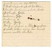
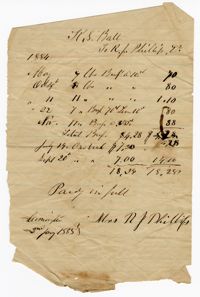
A list of items under the name of "Annie Bonnell." The other side is an account of medical visitations under the name "Mr. Sam Oliver" with associated figures in dollars.
Page 167 of the City Engineer's Plat Book with two plats. Plat 1 shows lots located between Meeting Street and a line labelled "So. Ca. R. R." Plat 2 shows lots located between Moultrie Street and Line Street, and between America Street and Meeting Street. Plat 2 also shows lots between Hampton Street and Moultrie Street, West of Meeting Street.
Page 168 of the City Engineer's Plat Book with one plat. The plat shows lots located between Hanover Street and Meeting Street, including the intersection of Cedar Street and Nassau Street.
Page 113 of the City Engineer's Plat Book with two plats. Plat 1 features "Shoal and Channel lots" located south of Tradd Street. Plat 1 also shows Gibbes Street, Council Street, two labels reading "ASHLEY RIVER EMBANKMENT," a line marking the edge of high land, a line marking the low water, and a line marking the edge of the channel. Plat 2 shows lots along New Street.
Page 98 of the City Engineer's Plat Book with three plats. Plat 1 shows lots between King Street and Meeting Street, including a stretch of railroad track and some marshlands. Plat 2 shows lots located near Rutledge Avenue. Plat 3 shows land located near a public road, showing a creek labelled "into Ashley," and stretches of marshland.
Page 94 of the City Engineer's Plat Book with two plats. Plat 1 shows lots and marshlands located near Meeting Street, and also shows King Street. Plat 2 features lots located between Meeting Street and a strip labelled "South Carolina R.R. Company." Plat 2 also shows Romney Street and Poinsett Street.
Page 96 of the City Engineer's Plat Book with two plats. Plat 1 shows lots located between King Street and Congress Street, and also shows Pinckney Street, Huger Street, and Moultrie Street. Plat 2 shows lots located near the intersection of Payne Street and Line Street, and also shows Kennedy Street.
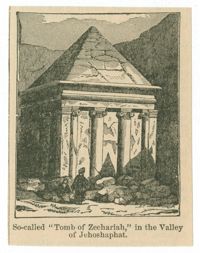
Black-and-white offset print reproduction of the Tomb of Zechariah in Jerusalem. From A dictionary of the Bible : comprising its antiquities, biography, geography, natural history and literature... by William Smith, published Philadelphia: Porter and Coates.
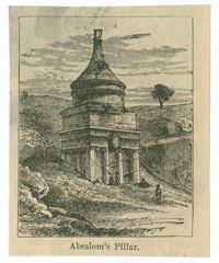
Black-and-white offset print reproduction of the Tomb of Absalom in Jerusalem. From A dictionary of the Bible : comprising its antiquities, biography, geography, natural history and literature... by William Smith, published Philadelphia: Porter and Coates.
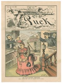
Caricature by Frederick Burr Opper published in the August 12, 1884, edition of Puck. The caption reads : "When 'honest men' fall out, thieves have to suffer."
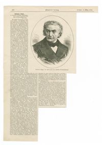
Black-and-white offset print reproduction with a portrait of cantor and composer Salomon Sulzer. Published in the March 15, 1884, edition of the Illustrirte Zeitung.
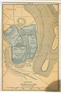
Color maps of ancient and modern Jerusalem. From A dictionary of the Bible : comprising its antiquities, biography, geography, natural history and literature by William Smith, published Philadelphia: John C. Winston Company.