Page 81 of the City Engineer's Plat Book with five plats. Plat 1 shows lots between Cooper Street and Blake Street, near their intersections with Drake Street. Plat 2 features an extension of Columbus Street stretching from Bay Street to the Cooper River, and also shows lots belonging to a cotton factory, the Northeastern Railroad Company (N.E.R.R. Co.), and the South Carolina Railway Company (So. Ca. R. Way Co.). Plat 3 features lots on a city block between Blake Street, Cooper Street, Drake Street, and Bay Street. Plat 4 shows land near Boundary Street, Pinckney Street, Doughty Street, and "Commings Creek." It also shows an island, a mill pond, several lots in the area, Hutson Street, Thomas Street, and President Street. Plat 5 shows land located between Calhoun Street and Bull Street, and Lynch Street and Rutledge Street, including Cannon Park.
Page 65 of the City Engineer's Plat Book with six plats. Plat 1 shows wharves and other structures located near the intersection of East Bay Street and Elliott Street, and also shows a building labelled "Old Post Office." Plat 2 features a wharf on the Cooper River, and shows several structures. Plat 3 shows wharves and brick storehouses located near the intersection of Prioleau Street and Queen Street. Plat 4 shows lots near the intersection of Bull Street and Smith Street. Plat 5 shows lots and structures located near the intersection of King Street and Morris Street. Plat 6 shows land located along a stretch of Coming Street, between Race Street and Sumter Street.
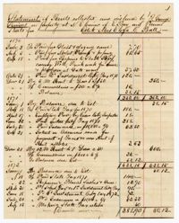
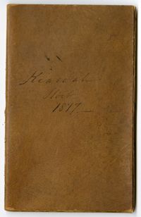
The Kiawah Stock Account Book, 1877-1882, is kept by a member of the Vanderhorst Family for their estate Kiawah Plantation on Kiawah Island, South Carolina. Entries include information on the numbers of livestock sold, list of expenses and marketing and account statements for the overseer Quash Stevens.