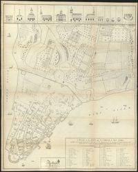
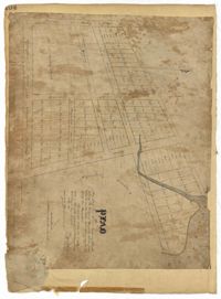
Page 66 of the City Engineer's Plat Book with fourteen plats. Plat 1 features buildings located near the intersection of King Street and Clifford Street. Plat 2 shows lots and structures located near the intersection of "Comings Street" and Wentworth Street. Plat 3 shows a lot and structures located on Pitt Street. Plat 4 shows lots located on a city block between Smith Street and Pitt Street, and between Montague Street and Wentworth Street. Plat 5 shows lots located on a city block between Montague Street and Wentworth Street, and between South Street and Rutledge Street. Plat 6 features a lot located near the intersection of "Comings Street" and Montague Street. Plat 7 shows lots and some structures located near the intersection of Bull Street and Coming Street. Plat 8 shows a lot and buildings located on Bull Street. Plat 9 Shows lots located near the intersection of Smith Street and Boundary Street. Plat 10 shows lots located on a city block between Lynch Street and Rutledge Street, and between Bull Street and Montague Street. Plat 11 shows lots and structures located near the intersection of Pitt Street and Bull Street. Plat 12 is features a lot located at the intersection of Pitt Street and Bull Street. Plat 13 Features lots located near the intersection of Bull Street and Lynch Street. Plat 14 shows lots located on Queen Street.
The Thomas Wright Bacot Jr. Estate Book is written by Robert Dewar Bacot between 1851-1854, following the death of Thomas W. Bacot in 1851. Acting as administrator for the estate, the book includes notices for demands against the estate, appraisals for items and belongings, including an enslaved woman named Nancy, and a written statement regarding the distribution of Thomas Bacot's shares to other members of the Bacot family.
Page 18 of the City Engineer's Plat Book with two plats. Plat 1 shows lots located near King Street, Moultrieville Street, and Huger Street. Plat 2 shows lots located near the Cooper River, Charlotte Street, and Washington Street.
Page 90 of the City Engineer's Plat Book with four plats. Plat 1 shows lots located between King Street and Russell Street, near Grove Street and Poinsett Street. Plat 2 shows lots located between Meeting Street and King Street, with a strip of land labelled "S.C.R.R.," a common acronym for the South Carolina Rail Road. Plat 3 features lots located near Boigard Street. Plat 4 features land located on the Ashley River, near Grove Street, shows a stream and several structures.
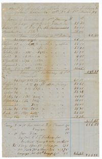
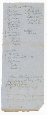
The Robert F.W. Allston Account Book, 1853-1855, records the numerous payments, receipts, debts and purchases and yearly crop information for Chicora Wood, Waverly and Nightingale Hall Plantations. Also included in the book are sections on births, deaths and marriages for enslaved people, writing down the first name of the men and women who married.
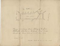
Plat of 202 acres in St. James Goose Creek belonging to James Headright. Details include trees on the property line and the names of neighboring property owners. Names associated with this plat are James Headright.
A notebook (n.d) attributed to Julius Theodore Porcher containing notes on microscopic organisms and cells, with drawings of microscopic cross-sections of wood fibers, hairs, and other objects of study.
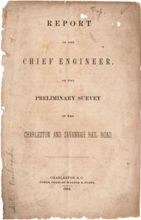
A copy of the last will and testament of Robert Pringle, written in 1774 and copied in 1854, where he divides his estate among his remaining relatives. He gives his daughter Elizabeth Pringle an enslaved girl named Jenny.
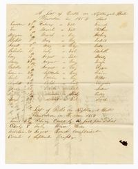
A list of enslaved children born at Nightingale Hall Plantation recording the month of birth and name of the child. Also noted are a list of deaths at Nightingale Hall Plantation.
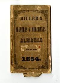
The 1854 Samuel Wilson journal is a Miller's Planters & Merchants Almanac repurposed as a journal. The journal contains handwritten meterological observations, weekly reports of yellow fever deaths, mortality tables, deaths of slaves including murder, notes on family matters, fires, hurriances and other events that took place in Charleston in the year 1854.
The front page of the slave bill of sale is the notation "Peter G. Snowden to H. W. Ravenel Trustee." The reverse side is a bill signed by Peter G. Snowden describing the sale of two slaves named Cupid and George for the sum of $1,500 to Henry Ravenel, trustee under the marriage settlement of Snowden and his wife Laura Ana.
A document listing the name of passengers onboard Captain Edward Barnwell's boat "Bowry Kate." The list includes thirty-six men and women as well as enslaved people.
Page 141 of the City Engineer's Plat Book with four plats. Plat 1 features a lot and structures located between Lynch Steet and the Ashley River, near Broad Street. It also shows Comings Creek, a pond, and a lot labelled "Clark & Steinmeyer." Plat 2 shows lots and structures located near the intersection of College Street and Calhoun Street. Plat 3 shows a lot and structures in "the City of Charleston in Ward No. 9." Plat 4 shows lots on and near Society Street, between Meeting Street and King Street.
Page 104 of the City Engineer's Plat Book with one plat. The plat shows lots located between Moultrie Street and Cunnington Street. It also shows Lemon Street, Lee Street, Price Street, and Magnolia Street. It also shows a plat labelled "Artilery Society" and another plat labelled "Magnolia Cemetery."
Page 46 of the City Engineer's Plat Book with five plats. Plat 1 shows lots on Butler Street, between Russell Street and Meeting Street. Plat 2 shows marshland and lots located near Huger Street and "Congress alias Pinckney Street." Plat 3 shows lots located near the intersection of "Rutledge formerly Congress Street" and Huger Street, and also shows Moultrie Street, Pinckney Street, and Legare Street. Plat 4 shows land near the intersection of King Street and Queen Street and several buildings. Plat 5 shows lots between "Hunter now Line" Street, and "Elliot St. now Spring St.," and also shows Rutledge Avenue and Boigard Street.
Page 6 of the City Engineer's Plat Book with three plats. Plat 1 shows a lot on the Ashley River. Plat 2 shows lots on Friend Street located between Broad Street and Tradd Street. Plat 3 features lots on King Street and includes a lot labeled "Orphan House Lot."
Caricature published in the Düsseldorfer Monathefte, Band 7, No. 31. In German, the text reads : --Gerichtsvollzieher: "Herr Hirsch treten Sie ein, nehmen Sie das Ihnen zuerkannte Pferd in Empfang - Sie stehen sich von allen Gläubigern am Besten." --Hirsch: "Wai - was seh ich - der Gaul is capot, is das mei Deckung für 800 Thalersch?" --Stalljung: ""Das hab' ich mir glaich gedacht, dass das arme Thier krepiert wird sai - seit 4 Wochen konnt ich ihm kai Futter bringe - weil der Stall von Gerichtswegen versiegelt war." In English, the text reads : --Bailiff: "Enter, Mr. Hirsch, take in the horse you were awarded. You are the top of the list of creditors." --Hirsch: "Oh - what am I seeing - the horse is ruined, is this my cover for 800 thalers?" --Stable boy: "That's the same thought I had, that the poor animal will die - for four weeks I could bring him no food - because the stable was sealed by the court."
Caricature published in the Düsseldorfer Monathefte, Band 7, No. 2. In German, the text reads : --"Wo sind se gewese?" --"Bin gewese ins Theater." --"Was habe se gegebe?"-- "24 Kreizer." --"Ich meine was für ä Stück." --"Nu, ein Sechsbatzner." --"Ach das is jo nich zum Aushalte." --"Das hab ich aach gefunde, drum bin ich weggange." In English, the text reads : --"Where were you?" --"I was at the theater" --"What did they have?" --"24 Kreuzer." --"I meant, what type of piece." --"Nu, a Sechsbatzner." --"Ah, that's unberable!" --"That's what I thought too, which is why I left." Kreuzer and Batzen are silver coins; 24 Kreuzer equals 6 Batzen (Sechsbatzner).
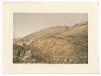
Color lithograph of the Tomb of Absalom, Tomb of Benei Hezir, and Tomb of Zechariah in the Valley of Jehoshaphat (Kidron Valley) in Jerusalem. Lithograph by William Simpson from a sketch by Mrs. Ewald. Printed by Day & Son. From Jerusalem and the Holy Land. Being a collection of lithographic views and native costumes, from drawings taken on the spot. By Mrs. Ewald.
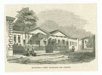
Black-and-white offset print reproduction of the exterior of the Karaite kenesas in Eupatoria. Published in the November 25, 1854, edition of The Illustrated London News.
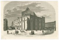
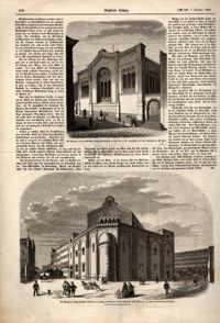
Black-and-white offset print reproduction of the exterior of the Große Gemeindesynagoge (Great Community Synagogue), also known as the Temple and the Alte Synagoge (Old Synagogue) in Leipzig. Published in the October 7, 1854, edition of the Illustrirte Zeitung.
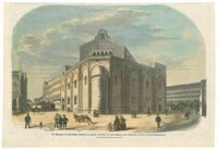
Hand-colored offset print reproduction of the exterior of the Große Gemeindesynagoge (Great Community Synagogue), also known as the Temple and the Alte Synagoge (Old Synagogue) in Leipzig. Published in the October 7, 1854, edition of the Illustrirte Zeitung.
Black-and-white lithographed caricature depicting Nicholas I of Russia applying the whip in order collect taxes to finance the Crimean War. The print shows the Tsar trying to extort funds from the Russian Jews by threatening them with pogroms. Lithograph by Destouches after a caricature by Honoré Daumier. Plate 91 of the series Actualités, published in the August 8, 1854, edition of Le Charivari.
Page from the October 7, 1854, edition of the Illustrirte Zeitung with black-and-white offset print reproductions of the exteriors of synagogues in Frankfurt am Main and Leipzing. Above, the synagogue of the Israelitische Religionsgesellschaft in the Schützenstraße in Frankfurt am Main, built by J. W. Renk. Below, the Große Gemeindesynagoge (Great Community Synagogue), also known as the Temple and the Alte Synagoge (Old Synagogue), built by Otto Simonson.
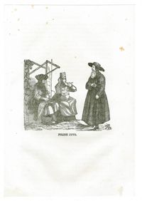
Black-and-white engraving of Jews from Poland. From The pictorial family encyclopedia of history, biography and travels : comprising prominent events in the history of the world, biographies of eminent men and interesting accounts of distinguished travelers by John Frost, published Auburn and Buffalo : Miller, Orton & Mulligan.
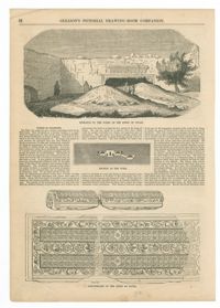
Black-and-white offset print reproduction of the Tombs of the Kings in Jerusalem. Published in the July 29, 1854, edition of Gleason's Pictorial Drawing-Room Companion.
Map of the city of New York as it was in the years 1742-1744, including the first Mill Street Synagogue of Congregation Shearith Israel. Lithograph by George Hayward after an original drawing by David Grim. Published in D. T. Valentine's Manual of the corporation of the city of New York for 1854.
Letter from Robert Woodward Barnwell to unnamed aunt. Barnwell discusses the start of his German education, including his efforts in avoiding American and English acquaintances to better immerse himself in the language, and describes the sorrow he feels for how hard German women have to work without servants. 1854.
Page 189 of the City Engineer's Plat Book with three plats. Plat 1 shows lots between Moultrie Street and Huger Street, near where they intersect with King Street. Plat 2 shows lots located between Huger Street and Pinckney Street, near King Street. Plat 3 features a lot and budlings on Line Street.
Page 10 of the City Engineer's Plat Book with two plats. Plat 1 shows plots located near Pointset Street and Grove Street between King Street and Russell Street. Plat 2 shows plots near Judith Street and Chapel Street, and includes "Beaufort's Court" and "Heyward's Court."
Page 68 of the City Engineer's Plat Book with eight plats. Plat 1 shows lots and some structures located near the intersection of Rutledge and Wentworth Street. Plat 2 features lots and some structures located near Bull Street, between Lynch Street and Gadsden Street, and has a label reading "Mill Pond." Plat 3 shows lots and buildings located near the intersection of Bull Street and Lynch Street. Plat 4 shows a city block between Wentworth Street and Beaufain Street, and Smith Street and Rutledge Street. Plat 5 shows lots located on Beaufain Street. Plat 6 features a lot located on "Comings Street," between Wentworth Street and Montague Street. Plat 7 shows a city block located between Wentworth Street and Montague Street, and Gadsden and Lynch Street. Plat 8 shows a city block located between Lynch Street and Rutledge Street, and Wentworth Street and Beaufain Street.
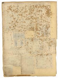
Page 123 of the City Engineer's Plat Book with six plats. Plat 1 shows lots and structures located on and near Calhoun Street, between Anson Street and Meeting Street. Plat 2 shows lots and structures located between East Bay Street and Cooper River. Plat 3 shows lots and buildings located near Meeting Street. Plat 4 shows lots near a road, and has a large hole in the middle. Plat 5 shows lots and buildings located on Beaufain Street. Plat 5 shows lots located near an intersection, and has several holes in the paper.


![[Herr Hirsch treten Sie ein…]](https://iiif.library.cofc.edu/iiif/2/36528/full/200,/0/default.jpg)
![[Wo sind se gewese?...]](https://iiif.library.cofc.edu/iiif/2/36402/full/200,/0/default.jpg)