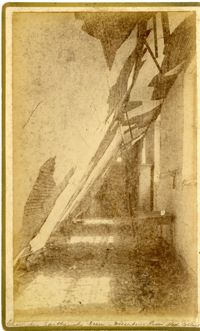
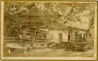
Caption: 'Cook's Earthquake Views of Charleston and Vicinity. Taken after the 31st of August, 1886. No.148, Landslide on the Ashley.' Handwritten at bottom, front: 'Charleston Earthquake view - Land slide near Summerville, S.C.'
Caption: 'Cook's Earthquake Views of Charleston and Vicinity. Taken after the 31st of August, 1886. No.60, J.M. Wilson, Meeting St.' Charleston city directory for 1886 shows James M. Wilson at 39 Meeting Street.
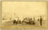
Handwritten at bottom, front: 'Charleston Earthquake scene - Marion Square - Citadel Academy in rear.' Tent village populated primarily by African-Americans. Policeman standing to the right.
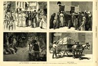
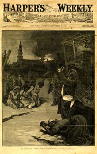
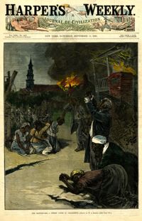
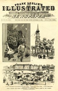
Caption: 'After The Earthquake At Charleston.--drawn by W.A. Rogers and W.P. Snyder from sketches by Frederic Remington and A.J. Gustin.--[see page 610.]' Individual captions: (top left): 'Open air preaching.' (top right): Subsistence committee.' (bottom left): 'Negro prayer-meeting.' (bottom right): 'Relief committee.' [full date September 18, 1886.]
Charleston Earthquake scene. Possibly from Cook's Earthquake views, No.157, scene near Accomodation Wharf. Written on front, at bottom: 'Charleston Earthquake Scene - ruins on Accomodation Wharf.' Charleston city directory for 1886 lists Accomodation Wharf as opposite 176 East Bay Street.
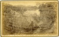
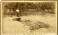
Caption: 'Cook's Earthquake Views of Charleston and Vicinity. Taken after the 31st of August, 1886. No.51, Wide fissure, Ten Mile Hill.' Handwritten at bottom, front: 'Charleston Earthquake scene - Large geyser near Ten Mile Hill.'
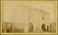
Caption: 'Cook's Earthquake Views of Charleston and Vicinity. Taken after the 31st of August, 1886. No.59, Pringle Smith, Meeting Street.' Written on front, at bottom: 'Earthquake scene Charleston, So.Ca.'
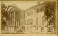
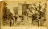
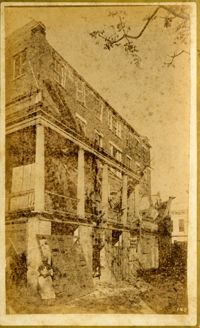
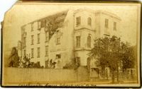
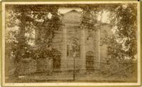
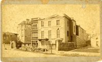
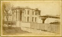
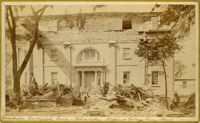
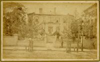
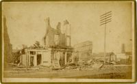
Caption: 'Cook's Earthquake Views of Charleston and Vicinity. Taken after the 31st of August, 1886. No.114, residence Col. Inglesby.' Charleston city directory for 1886 shows Charles Inglesby at 20 Meeting Street.
Caption: 'Cook's Earthquake Views of Charleston and Vicinity. Taken after the 31st of August, 1886. No.46, Club House, Otranto, rear.' Written on front, at bottom: 'Charleston Earthquake scene - fallen wall, Otranto Club House.'
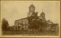
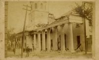
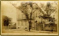
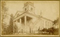
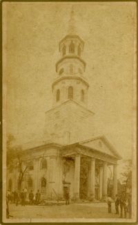
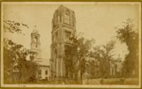
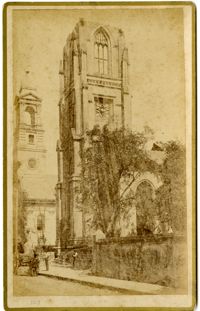
Caption: 'Cook's Earthquake Views of Charleston and Vicinity. Taken after the 31st of August, 1886. No. 17, St. Paul's Church.' St. Luke and St. Paul's Episcopal Cathedral, Coming Street.
Caption: 'Cook's Earthquake Views of Charleston and Vicinity. Taken after the 31st of August, 1886. No.76, First Baptist Church, front.' Handwritten at bottom, front: 'Charleston Earthquake scene - First Baptist Church, Church Street.'
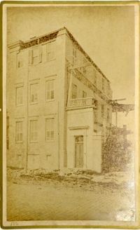
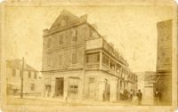
Charleston Earthquake scene. Written on front, at bottom: 'Sailor's Home, Charleston, S.C. after the Earthquake.' Sign at top of building reads: 'Charleston Port Society.'
Caption: 'Cook's Earthquake Views of Charleston and Vicinity. Taken after the 31st of August, 1886. No.133, 5 and 7 Broad Street.' Written on front, at bottom: 'Walker, Evans & Cogswell, Broad St.' Charleston City Directory for 1886 shows Walker, Evans & Cogswell at 3-5 Broad Street. Etiwan[Phosphate] Company is at 7 Broad.
Caption: 'Cook's Earthquake Views of Charleston and Vicinity. Taken after the 31st of August, 1886. No.21, Broad Street, south side.' Sign on building, at right, reads: 'Cigars & Tobacco' and 'W.W. Smith, 27.' Charleston city directory for 1886 lists William M. Smith, seal, stencil and stamp works, at 29 Broad Street.
Caption: 'Cook's Earthquake Views of Charleston and Vicinity. Taken after the 31st of August, 1886. No.25, Vendue Range.' Written on front, at bottom: 'Charleston Earthquake scene - Vendue Range, foot of Queen St. near the wharf.' Sign for John Werner visible. Charleston city directory for 1886 shows business at 27 Vendue Range.
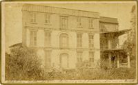
Caption: 'Cook's Earthquake Views of Charleston and Vicinity. Taken after the 31st of August, 1886. No.62, Wm. [William] Ravenel, East Battery, front.' Written on front, at bottom: 'Earthquake scene, Charleston, So.Ca. - Ravenel House'
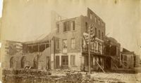
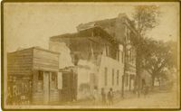
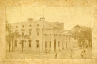
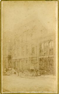
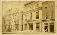
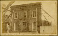
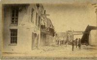
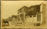
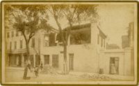
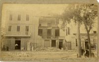
Charleston Earthquake scene. Written on front, at bottom: 'Broad St.' Image shows The News and Courier. Charleston city directory for 1886 lists it at 19 Broad Street.
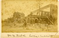
Charleston Earthquake scene. Written on front, at bottom: 'Wm M. Bird & Co. East Bay & Cumberland St.' Sign on building reads: '205, Wm. M. Bird & Co' and '203, Wm E. Holmes.'
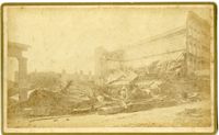
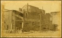
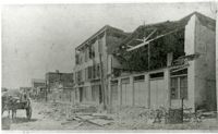
Caption: 'Cook's Earthquake Views of Charleston and Vicinity. Taken after the 31st of August, 1886. No.27, Hayne Street - ruins of three large buildings.' Sign on column at left reads: 'Charleston Bag Factory.' Charleston city directory for 1886 shows a bag factory at 15-19 Hayne Street.
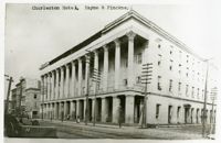
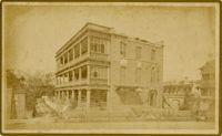
Charleston Earthquake scene. Possibly a copy of No.11 of Cook's Earthquake Views. Shows damage to the Charleston Hotel, demolished in 1960, which stood at 200 Meeting Street. 'Charleston Hotel, Hayne & Pinckney' is typewritten onto the image. Hayne and Pinckney Streets were two of the boundary streets that surrounded the hotel.
Charleston Earthquake scene. Sign at bottom of image: 'Mr. August Melm's room, 21 King Street.' Also, written on front, at bottom: 'Earthquake - Charleston S.C. 1886.' Charleston city directory for 1886 lists August Melm, a local attorney, as boarding at 21 King Street.
Caption: 'Cook's Earthquake Views of Charleston and Vicinity. Taken after the 31st of August, 1886. No.115, Corner [of] Market and Anson Streets.' Sign on building reads: 'Ship & Family Groceries.' Written on front, at bottom: 'Charleston Earthquake view - cor. Market and Anson sts.'
Charleston Earthquake scene. Written on reverse: 'East Battery, just below Atlantic Street. Edmonston [sic] House, later the Charles Alston residence. Now (1947) the residence of J.J. Pringle Smith. Old Holmes house on left. Earthquake of 1886 - Charleston, S.C.'
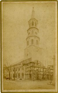
Caption: 'South Carolina.--The recent earthquakes at Charleston--typical scenes of the calamity. From sketches by C. Upham--see page 71. 1. Scene on the stairway of the Charleston Hotel during a shock. 2. Taking down St. Philip's Steeple. 3. Scene on Marion Square, opposite the Citadel--a city of tents.' [full date September 18, 1886.]
Caption: 'Cook's Earthquake Views of Charleston and Vicinity. Taken after the 31st of August, 1886. No.40, Bishop's house, Broad Street.' Handwritten at bottom, front: 'Charleston Earthquake scene - Bishop Northrup's Residence.' Charleston city directory for 1886 shows Bishop Henry P. Northrop at 114 Broad Street.
Caption: 'Cook's Earthquake Views of Charleston and Vicinity. Taken after the 31st of August, 1886. No.150, Mariner's Church, exterior." Also, handwritten at bottom of image: 'Charleston Earthquake scene - Mariners' Church, Church Street ? East Bay'
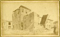
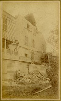
Charleston Earthquake Scene. Possibly from Cook's Earthquake Views, No.56, Alderman Murray's residence, Wentworth Street.' Charleston city directory for 1886 shows Andrew B. Murray at 175 Wentworth.
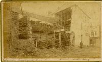
Charleston Earthquake scene. Written on front, at bottom: 'Charleston Earthquake scene - warehouse on Atlantic Wharf.' Charleston city directory for 1886 lists Atlantic Wharf at the rear of the Post Office.
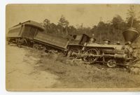
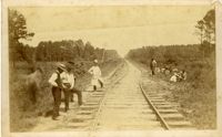
Charleston Earthquake scene. Handwritten on reverse: '9 mile bottom - South Carolina railroad - chasm on left. Track was originally a tangent. Caused by earthquake, 1886. Track cut of line.'
Caption: 'Cook's Earthquake Views of Charleston and Vicinity. Series No.2.' No.156, Scene near Brown's Wharf.' Charleston city directory for 1886 lists Brown's Wharf as opposite Vendue Range.
Caption: 'Cook's Earthquake Views of Charleston and Vicinity. Taken after the 31st of August, 1886. No.131, residence J.N. Robson, south side.' Charleston city directory for 1886 shows James N. Robson at 200 Coming Street.
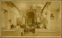
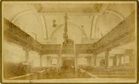
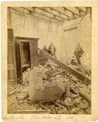
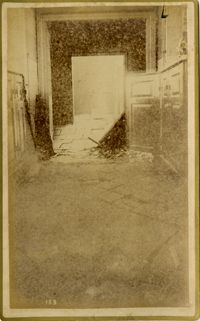
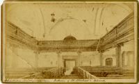
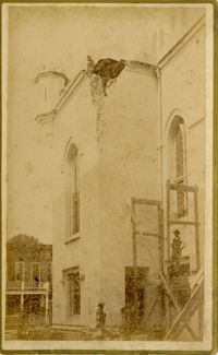
Caption: 'Cook's Earthquake Views of Charleston and Vicinity, Series No.2. No.153, Main aisle of St. Michael's Church, showing fissures and upheavals.'
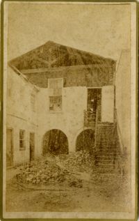
Charleston Earthquake scene. Possibly from Cook's Earthquake Views. No.68, John Kenney, Tradd Street. Charleston city directory for 1886 shows listing for John B. Kenney at 142 Tradd.
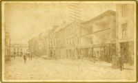
Caption: 'Cook's Earthquake Views of Charleston and Vicinity. Taken after the 31st of August, 1886. No.24, Market Street, north side.' Charleston Port Society building is pictured. Written on front, at bottom: 'View on Market St. at Charleston, S.C. after the Earthquake.'
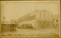
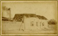
Caption: 'Cook's Earthquake Views of Charleston and Vicinity. Taken after the 31st of August, 1886. No.38, Bagging Factory, East end.' Charleston city directory for 1886 shows the office of the Charleston Bagging Manufacturing Company at 110 East Bay. Written on front, at bottom: 'Charleston Earthquake Scene - Rear of Bagging Factory.'
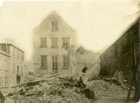
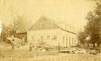
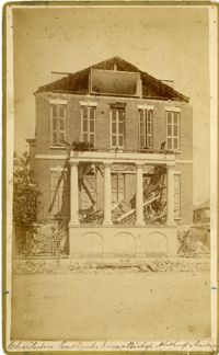
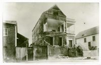
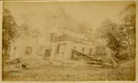
Charleston Earthquake scene, residence on Ashley Street. Handwritten on reverse: 'The residence of the Mayor of Charleston shattered by the Earthquake, Aug[us]t 31st 1886 and occupied by the Mayor's family unitl May 1887. Courtnay's [sic] residence. E.V.V. made bust of this man.'
Caption: 'Cook's Earthquake Views of Charleston and Vicinity. Taken after the 31st of August, 1886. No.67, G.W. Williams, Jr., Atlantic Street.' Charleston city directory for 1886 shows George W. Williams, Jr. at 2 Atlantic Street.
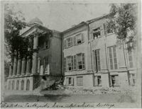
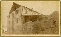
Caption: 'Cook's Earthquake Views of Charleston and Vicinity. Taken after the 31st of August, 1886. No.5, Medical College.' Handwritten at bottom, front: 'Charleston Earthquake scene - Charleston Medical College. Queen Street.'
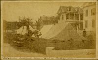
Caption: 'Cook's Earthquake Views of Charleston and Vicinity. Taken after the 31st of August, 1886. No.86, tents, Rutledge St[reet] Terrace.' Handwritten at bottom, front: 'Charleston Earthquake views - tents on Rutledge Terrace.'
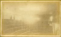
Caption: 'Cook's Earthquake Views of Charleston and Vicinity taken after the 31st of August, 1886. No.2, St. Michael's Church, Interior.' Handwritten along bottom: 'Charleston Earthquake scene - interior of St. Michael's Church.' Very similar to MK 4133.
Charleston Earthquake scene. Possibly from Cook's Earthquake views, No.31, Tenement houses on East Bay. Written on front, at bottom: 'Charleston Earthquake scene - house on East Bay near Tradd.' Sign on building at left, reads: 'Ship & Family Groceries' known to be at the corner of East Bay and Queen. Sign on building at right, reads: '65' and possibly 'Sahlmann.' 1886 Charleston city directory lists L. Sahlmann, Hay & Grain, at 83 East Bay.
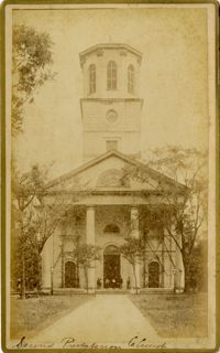
Caption: 'Cook's Earthquake Views of Charleston and Vicinity. Taken after the 31st of August, 1886. No.81, Flinn's Church.' Handwritten notation next to it and at bottom, front: '2nd Presbyterian Church.'
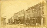
Charleston Earthquake scene. Copy of No.24 of Cook's Earthquake views. Shows damage to the buildings on the north side of Market Street, including the Sailor's Home.
Caption: 'Cook's Earthquake Views of Charleston and Vicinity. Taken after the 31st of August, 1886. No.66, _____ Alston, East Battery.' Charleston city directory for 1886 shows various members of the Alston family at 21 East Battery.
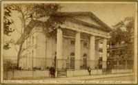
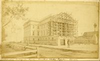
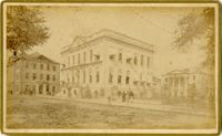
Caption: 'Cook's Earthquake Views of Charleston and Vicinity. Taken after the 31st of August, 1886. No.36, Court House, City Hall, and Fireproof Building.'