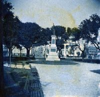
View of the Japser Monument, White Point Garden, facing north. The Villa Margherita is visible in the background on the right corner of Church Street and South Battery. Page 5, Photo 2 of collection. 3.5" x .35" cyanotype print. View of the Japser Monument, White Point Garden, facing north. The Villa Margherita is visible in the background on the right corner of Church Street and South Battery. Page 5, Photo 2 of collection. 3.5" x .35" cyanotype print.
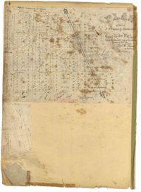
Page 254 of the City Engineer's Plat Book with one plat. A "Plat of Wagner Terrace," showing numerous lots and Hampton Park. Streets shown include Dunneman Street, Grove Street, and Rutledge Avenue.
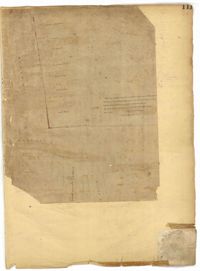
Page 214 of the City Engineer's Plat Book with two plats. Plat 1 shows lots located between Savage Street and Chisolm Street, and between Broad Street and Tradd Street. Plat 1 also shows Rutledge Avenue. Plat 2 shows a similar area to Plat 1, but also includes New Street, Franklin Street, Trapman Street, and Lynch Street.
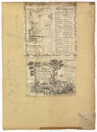
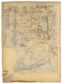
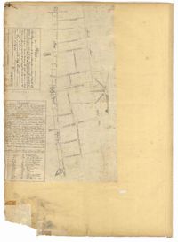
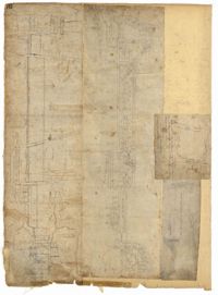
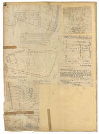
Page 203 of the City Engineer's Plat Book with one plat. An illustrated title card reads "A Plan of Charles Towne Copied with a Pen from an Old Dilapidated Plat without a Date," and depicts a harbor scene with Europeans and enslaved people. The plat labels landmarks and streets using capital and lowercase letters. These locations include Broad Street, the "State House," several churches, Boundary Street, the Exchange, an armory, and a beef market.
Page 193 of the City Engineer's Plat Book with one plat. The plat shows lots located between Congress Street and Fishburne Street, and from Rutledge Street to past President Street. The plat also shows Payne Street.
Page 126 of the City Engineer's Plat Book with three plats. Plat 1 shows lots and structures located between George Street and Boundary Street, and between Meeting Street and Scarborough Street. Plat 2 shows lots on Anson Street, with one building labelled "Palmetto Engine House." Plat 3 shows a large swathe of land, including marshes and streams. One stream is labelled "Vardells CK," and a line towards the right of the plat is labelled "North Eastern Rail Road." The streets on this plat include King Street, Hampton Street, Moultrie Street, Meeting Street, America Street, Bay Street, Stewart Street, Cooper Street, and Line Street.
Page 111 of the City Engineer's Plat Book with one plat. This plat shows lots located near the intersection of East Bay Street and Broad Street. It also shows a building labelled "EXCHANGE," and Gillon Street.
Page 44 of the City Engineer's Plat Book with two plats. Plat 1 shows land between Meeting Street and a stretch of Marsh, and shows a stretch of railroad. Plat 1 also shows "Nassaw Street," Hanover Street, America Street, William Street, Isabella Street, "Rumney Street," Center Street, and "Cool-Blow Street." Plat 2 shows plats on "Rumney Street," between King Street and Meeting Street, including the intersection with Russell Street.
Page 70 of the City Engineer's Plat Book with two plats. Plat 1 shows lots located near the intersection of "Broad Road" and George Street, with several buildings and bodies of water. Plat 2 shows a mill pond, marshlands, and structures located near the Ashley River.
Page 58 of the City Engineer's Plat Book with six plats. Plat 1 shows lots between Broad Street and Short Street, near their intersections with Mazyck Street. Plat 2 features lots on Greenhill Street, Limehouse Street, and Tradd Street. Plat 2 also shows a line labelled "Edge of High Land." Plat 3 shows lots near Broad Street, including lots labelled "Hawens Square" and "Burying Ground." Plat 3 also shows structures labelled "Magazine" and "Work House." Plat 4 shows lots located on King Street. Plat 5 shows land located between Meeting Street and Lee Street, and a dotted line labelled "City Boundary." Plat 6 shows lots located between President Street and Norman Street.
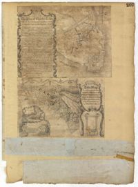
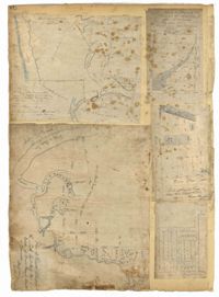
Page 207 of the City Engineer's Plat Book with two plats. Plat 1 is titled "The Plan of Charles Town With its Entrenchments and those made during the Siege by the English 1780," and shows Queen Street, Church Street, Tradd Street, King Street, Broad Street, the State House, the Market, the Arsenal, an "Old Church" and a "New Church." It also shows certain geographic features, including "Cummins Point," Cannons Point, and Hampstead Hill. Plat 2 has a label reading "This Map In every particular copied with a Pen from an Old Plat of Charles Town dated 1671 found in a Book of Plats of various parts of U.S.A. printed in London 1671." Plat 2 shows several geographic features such as rivers and islands, and features numerous illustrations. The largest illustration depicts two groups of people interacting from either side of a stream. Each group holds a single spear.
Page 14 of the City Engineer's Plat Book with one plat. The plat shows land between Bay Street and Church Street, including stretches of Tradd Street, Broad Street, and Queen Street.
Page 12 of the City Engineer's Plat Book with two plats. Plat 1 shows plots near Coming Street, St. Phillip Street, King Street, Meeting Street, and Vanderhorst Street. Plat 2 Shows lots on Queen Street near the intersections with East Bay Street and Prioleau Street, has the label "Charleston Harbour Cooper River" on the right-hand margin.
Page 132 of the City Engineer's Plat Book with two plats. Plat 1 features a plan for the College of Charleston, showing buildings labelled "Charleston College," "Library," "Lodge," and "Charleston Orphan House." Streets on this plat include George Street, Smith Street, College Street, Calhoun Street, St. Philips Street, and Vanderhorst Street. Plat 2 shows lots located near the intersection of Montague Street and Lynch Street.
Page 23 of the City Engineer's Plat Book with one plat. The plat shows lots, buildings, shoals, and mud flats located near the Charleston Harbor on the Cooper River, Concord Street, Pinckney Street, and East Bay Street.
Page 140 of the City Engineer's Plat Book with six plats. Plat 1 shows lots and structures located on and near Queen Street, between King Street and Meeting Street. Plat 2 shows lots located on Rutledge Street. Plat 3 shows lots located between George Street and Burns Lane, near where they intersect with Meeting Street. One lot is labelled "Property of Charleston High School." Plat 4 shows lots and structures located between Lynch Street and the Ashley River, near Broad Street and Beaufain Street. Plat 5 shows lots and structures located on the corner of King Street and Society Street. Plat 6 shows the same area as Plat 5, but with some changes to the structures.
Page 101 of the City Engineer's Plat Book with two plats. Plat 1 shows lots located between Washington Street and Wharf Street, and between Calhoun Street and Laurens Street. Plat 2 shows lots located near the intersection of Rutledge Avenue and Line Street, with several buildings labelled.
Page 78 of the City Engineer's Plat Book with five plats. Plat 1 features land and lots located near the Ashley River, including geographic features such as marshland, high land, and bodies of water. Plat 1 also shows Boundary Street, Hutson Street, Doughty Street, Bee Street, Elliot Street, Cannon Street, President Street, and Thomas Street. Plat 2 shows a city block between Doughty Street and Bee Street, and between President Street and Thomas Street, with some marsh labelled. Plat 3 features land and lots located near the Ashley River, with shoals and streams labelled. Plat 3 also shows Boundary Street, Pinckney Street, Cannon Street, Hutson Street, Doughty Street, and Bee Street. Plat 4 shows lots located near the intersection of Calhoun Street and Lucas Street, and shows several structures and a stretch of a creek. Plat 5 shows lots features lots located between Lucas Street and Ashley Street, and Mill Street and Doughty Street. Plat 5also shows Palmetto Street, President Street, and a lot labelled "U. S. Arsenal Square."
Page 24 of the City Engineer's Plat Book with three plats. Plat 1 shows lots located near King Street, Meeting Street, Wolf Street, March Lane, and Reid Street, including a portion of land labelled "Old fish pond low & broken land" and large label reading "Part of Hampstead." Plat 2 shows lots and features near the Charleston Harbor on the Cooper River, Boundary Street, Charlotte Street, Washington Street, and East Bay Street, and notes the "High Water Mark at Common Tides." Plat 3 shows lots located Meeting Street, Elizabeth Street, Ann Street, John Street, "Chapple Street," Alexander Street, and Washington Street, including a lot labelled "Tobacco Inspection."
Page 183 of the City Engineer's Plat Book with five plats. Plat 1 shows lots located along Simons Street, between King Street and a stretch of marshland. Plat 2 shows lots on and near "Simmons" Street. It also shows lots near King Street and Romney Court. Plat 3 shows lots located near the intersection of King Street and Grove Street. Plat 4 shows lots and structures located near the intersection of Simons Street and King Street. Plat 5 shows lots along Simons Street, located between King Street and a stretch of marshland.
Page 76 of the City Engineer's Plat Book with three plats. Plat 1 shows land roughly between the Ashley River and Coming Street, and roughly between Elliot Street and Comings Creek. Plat 1 also shows multiple streams, marshes, and islands. It also includes Boundary Street, Doughty Street, Bee Street, Cannon Street, Smith Street, Pinckney Street, and Thomas Street. Plat 2 shows lots and some buildings located between Spring Street and a marsh, along an road labelled "Court." Plat 3 features lots located between Morris Street and Radcliffe Street, near their intersections with Pitt Street, "Commings Street," St. Philips Street, and King Street. Plat 3 also shows some marshland. Plat 4 features lots located between Smith Street and Coming Street, and between Radcliffe Street and Vanderhorst Street. Plat 4 also shows the intersection of Warren Street and Thomas Street.
Page 86 of the City Engineer's Plat Book with four plats. Plat 1 shows land starting west of Legare Street and ending east of America Street. Plat 1 also includes Line Street, Pinckney Street, King Street, Meeting Street, America Street, a public square, and several marshes. Plat 2 shows a stretch of land starting west of Legare Street and ending at Drake Street. Plat 2 also shows Line Street, Sheppard Street, Coming Street, St. Phillips Street, King Street, Meeting Street, America Street, a lot labelled "Est of Nells Rope yard," and several marshes. Plat 3 shows 3 plots of land near a road, a marsh, and a pond. Plat 4 shows land near King Street, where it intersects with Huger Street and Charlotte Street.
Page 66 of the City Engineer's Plat Book with fourteen plats. Plat 1 features buildings located near the intersection of King Street and Clifford Street. Plat 2 shows lots and structures located near the intersection of "Comings Street" and Wentworth Street. Plat 3 shows a lot and structures located on Pitt Street. Plat 4 shows lots located on a city block between Smith Street and Pitt Street, and between Montague Street and Wentworth Street. Plat 5 shows lots located on a city block between Montague Street and Wentworth Street, and between South Street and Rutledge Street. Plat 6 features a lot located near the intersection of "Comings Street" and Montague Street. Plat 7 shows lots and some structures located near the intersection of Bull Street and Coming Street. Plat 8 shows a lot and buildings located on Bull Street. Plat 9 Shows lots located near the intersection of Smith Street and Boundary Street. Plat 10 shows lots located on a city block between Lynch Street and Rutledge Street, and between Bull Street and Montague Street. Plat 11 shows lots and structures located near the intersection of Pitt Street and Bull Street. Plat 12 is features a lot located at the intersection of Pitt Street and Bull Street. Plat 13 Features lots located near the intersection of Bull Street and Lynch Street. Plat 14 shows lots located on Queen Street.
Page 34 of the City Engineer's Plat Book with four plats. Plat 1 shows lots located on South Bay Street. Plat 2 shows land located between Beaufain Street and Queen Street, near Smith Street, Wilson Street, and Franklin Street. Plat 3 shows lots located near Beaufain Street's intersections with Pitt Street and Wilson Street. Plat 4 features a lot and its buildings located on Meeting Street.
Page 50 of the City Engineer's Plat Book with seven plats. Plat 1 shows wharves and other structures located on East Bay Street. Plat 2 shows lots and buildings located on the intersection of Tradd Street and Meeting Street. Plat 3 shows lots located near the intersection of Broad Street and Rutledge Street. Plat 4 shows lots and buildings located near Gibbes Street. Plat 5 shows lots located near the intersection of Society Street and East Bay Street. Plat 6 shows lots and buildings near Broad Street. Plat 7 shows lots located between South Bay Street and the Ashley River, near Legare Street.
Page 130 of the City Engineer's Plat Book with three plats. Plat 1 shows lots located on a city block between Meeting Street and Scarborough Street and between Boundary Street and George Street. Plat 2 shows lots and structures located on East Bay Street. Plat 3 shows lots located on the Cooper River channel of the Charleston Harbor, near Concord Street and Wharf Street.
Page 151 of the City Engineer's Plat Book with two plats. Plat 1 shows lots and structures located on and near Anson Street. Plat 2 shows lots and structures located between Coming Street and the Ashley River Channel, and between Elliott Street and Mill Creek. The plat also shows 50 acres of marsh, several bodies of water, Boundary Street, Pinckney Street, Cannon Street, and President Street.
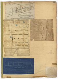
Page 127 of the City Engineer's Plat Book with four plats. Plat 1 shows lots and wharves, including Accommodation Wharf and Brown's Wharf. Plat 2 shows structures on Anson Street. Plat 3 shows lots located near the intersection of Pinckney Street and Anson Street. Plat 4 shows lots located on and near Gadsden Street, between Pinckney Street and King Street.
Page 52 of the City Engineer's Plat Book with seven plats. Plat 1 features a lot located on Queen Street. Plat 2 shows land between New Street and the Ashley River Channel, including stretches of Tradd Street, Broad Street, New Street, Savage Street, Rutledge Street, and Lynch Street. Plat 2 also shows some marshlands in the area. Plat 3 shows lots located along Greenhill Street, near the intersection with Tradd Street. Plat 4 shows an area similar to Plat 2, with certain buildings and marshlands labelled. Plat 5 shows a lot located on the intersection of Tradd Street and New Street, featuring several buildings and other structures. Plat 6 shows land located near Tradd Street, with marshes and shoals labelled. Plat 7 features lots between Tradd Street and Gibbes street, and has a label reading "City marshland." Plat 7 also shows New Street, Savage Street, and Council Street.
Page 161 of the City Engineer's Plat Book with two plats. Plat 1 shows lots located near the intersection of South Street and Drake Street, and also shows America Street. Plat 2 shows a "Plan of Hampstead," which shows Meeting Street, a public square, Blake Street, Drake Street, Bay Street, Amherst Street, Reid Street, and Reid Street.
Page 225 of the City Engineer's Plat Book with one plat. The plat shows lots and marsh located east of King Street and north of Line Street. It also shows Meeting Street.
Page 118 of the City Engineer's Plat Book with four plats. Plat 1 shows lots and structures on East Bay Street. Plat 2 shows lots along Meeting Street. Plat 3 shows lots located near the intersection of Inspection Street and Marsh Street. Plat 4 shows lots and structures along Anson Street, between George Street and Boundary Street.
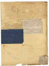
Page 107 of the City Engineer's Plat Book with two plats, labelled 3 and 4. Plat 3 features a lot and buildings located on the intersection or Tradd Street and East Bay Street. Plat 4 shows lots located near Gibbes Street, Tradd Street, New Street, and Savage Street. Plat 4 also shows three lines, labelled "Edge of high land," "Low water by Parker," and "Edge of Channel by Purcell and Parker."
Page 88 of the City Engineer's Plat Book with eight plats. Plat 1 shows a stream and marshland starting at the Ashley River. Plat 2 features land located near the Ashley River and Grove Street. It also features several structures, some marshland, and a creek. Plat 3 shows land located near Grove Street, including some structures, some marshland, and a stream. Plat 4 shows land located Grove Street, including some buildings, a creek, and marshland. Plat 5 shows lots located between a stretch of marsh and Rutledge Avenue. Plat 5 also shows Congress Street, Legare Street, Huger Street, Moultrie Street, and a race track. Plat 6 features Washington Race Course, located between Grove Street and Moultrie Street, and between Congress Street and an unlabeled Street. Plat 7 shows "34 acres of Marsh" located between the Ashley River and a public cemetery. Plat 8 shows marshland located on the Ashley River, near "new Spring Street" and a creek.
Page 32 of the City Engineer's Plat Book with three plats. Plat 1 shows lots located near the intersection of Tradd Street and Limehouse Street. Plat 2 shows lots located near Elliott Street, Broad Street, and Line Street, near the intersections with Rose Lane, Laurel Street, Percy Street, and Coming Street. Plat 3 shows lots and buildings located between St. Phillip Street and King Street, and Radcliffe Street and Warren Street.
Page 26 of the City Engineer's Plat Book with two plats. Plat 1 is a plan for a public square located near the intersection of Pinkney Street and Boundary Street, and shows a creek. Plat 2 features a lot located on the Ashley River channel and "Commings Creek," located near the intersections of Pinckney Street and Boundary Street, and Bull Street and Rutledge Street. Plat 2 also labels a pond, an island, and "Cannon's Point." Plat 3 shows lots located between Boundary Street and Bull Street, near the intersections with Barre Street, Gadsden Street, Lynch Street, Rutledge Street, Pitt Street, and "Comming Street."
Page 69 of the City Engineer's Plat Book with eight plats. Plat 1 shows land located on either side of Burns Lane, and also shows George Street. Plat 2 features a lot and some buildings on George Street. Plat 3 features lots located on and near King Street, between Beaufain Street and Lynch Street. Plat 4 shows a city block located between Beaufain Street and Wentworth Street, and between Pitt Street and Kirkland Lane. Plat 5 shows lots and some buildings located near the intersection of Smith Street and Montague Street. Plat 6 shows lots on Coming Street, between Montague Street and Wentworth Street. Plat 8 shows lots and some buildings located on Pitt Street, including a lot labelled "The Brown Fellowship Society Cemetery."
Page 51 of the City Engineer's Plat Book with seven plats. Plat 1 shows land located between Tradd Street and the Ashley River, and labels several features of geography such as a patch of marsh and some land labelled "Hard at low water." Plat 1 also shows a lot labelled "City Lands." Plat 2 shows lots and buildings located near the intersection of Tradd Street and Savage Street. Plat 3 shows land located on the west side of New Street. Plat 4 features a lot located at the intersection of New Street and Tradd Street. Plat 5 features lots located near the intersection of New Street and Tradd Street. Plat 6 shows lots located on and near Tradd Street. Plat 7 shows structures located near the intersection of New Street and Broad Street, including a building labelled "Theatre."
Page 54 of the City Engineer's Plat Book with six plats. Plat 1 shows lots located near the intersection of Broad Street and Friend Street. Plat 2 shows land between the Ashley River's low water mark and Smith Street, and between Beaufain Street and Broad Street. It also labels Comings Creek, and an "Edge of High Land." Other Streets on Plat 2 include "Barre Street," Gadsden Street, Beaufain Street, Lynch Street, Queen Street, and Rutledge Street. Plat 3 shows numerous city blocks, "School Land," and a large creek near the Ashley River. Other streets on Plat 3 include Beaufain Street, Wentworth Street, Montague Street, Bull Street, and Pitt Street. Plat 4 shows a similar stretch of land to Plat 3. Plat 5 shows features a lot on Beaufain Street. Plat 6 shows a lot and buildings located near the intersection of King Street and Hutson Street.
Page 41 of the City Engineer's Plat Book with six plats. Plat 1 shows land between Mount Street and Congress Street, and between a private street and "CITY LANDS Potter's Field." Plat 2 shows lots near Chestnut Street and near Spring Street, Ashton Street, Always Street, Lilly Street, and Pine Street. It also shows a few bodies of water. Plat 3 shows lots near Meeting Street's intersections with Market Alley, and State House Alley. It also labels a court house, the Treasury and Guard House, and St. Michael's Church. Plat 4 shows a stretch of land near President Street, Logan Street, Pinckney Street, Fishburne Street, Mount Street, Congress Street, and shows bodies of water and highlands. Plat 5 shows lots and buildings near the intersection Church Street and Water Street.
Page 49 of the City Engineer's Plat Book with six plats. Plat 1 shows land on the Cooper River. Plat 2 shows land located near Broad Street's intersections with Gadsden Street and Lynch Street, and a stream labelled "Comings Creek." Plat 3 shows wharfs and buildings along the Cooper River and near Champney Street. Plat 4 shows wharves and other structures between East Bay Street and the Cooper River. Plat 5 shows land near South Bay Street's intersections with Meeting Street and Church Street, including a lot labelled "Battery Garden" and a structure labelled "Bathing House."
Page 16 of the City Engineer's Plat Book with five plats. Plat 1 shows lots close to the Ashley River located near Tradd Street and Gibbes Street, including a marsh flat labelled as "City Lands." Plat 2 shows lots located near the intersection of Tradd Street and Council Street, including "City marshlands." Plat 3 shows lots located near Gibbes Street and South Bay Street, and includes a dotted line labelled "Low Water Mark." Plat 4 shows land located between Ellery Street and Old Church Street, including a stretch of Raper Street. Plat 5 shows land near the intersection of South Bay Street and "Legare or Johnson Street," and close to the "Low Water" of the Ashley River.
Page 19 of the City Engineer's Plat Book with six plats. Plat 1 shows lots and buildings located near the intersection of Pitt Street and Bull Street. Plat 2 shows lots and buildings located near the intersection of Meeting Street and Reid Street. Plat 3 shows lots between King Street and Congress Street, also located near Grove Street and Moultrie Street. Plat 4 shows a lot on Amen Street labelled "Thomas N. Gadsen Esq." and noting multiple brick buildings. Plat 5 shows lots located on Cumberland Street. Plat 6 shows lots located on Amen Street and two two-story brick buildings.
Page 77 of the City Engineer's Plat Book with seven plats, labelled 1 through 8 with Plat 3 missing. Plat 1 shows lots located between Smith Street and King Street, and between Morris Street and Radcliffe Street. Plat 1 also shows Coming Street and St. Philips Street, and a label reading "Bethlohim Congregation." Plat 2 shows lots and some structures near the intersection of King Street and Warren Street. Plat 4 shows lots between Smith Street and King Street, and north of Radcliffe Street. Plat 4 also shows Coming Street, St. Philips Street, Morris Street, and a lot labelled "Bethlehem Congregation." Plat 5 shows lots located near the intersection of Morris Street and St. Philips Street. Plat 6 shows lots located between Morris Street and "Hunter St now Line," and east of Coming Street. Plat 8 features a lot and structures located on the corner of St. Philips Street and Morris Street.
Page 71 of the City Engineer's Plat Book with eight plats. Plat 1 shows lots and structures on a city block between Rutledge Street and Smith Street, and between Beaufain Street and Wentworth Street. Plat 2 shows lots located near the intersection of Moore Street and Meeting Street. Plat 3 shows lots and structures located near the intersection of King Street and Beaufain Street. Plat 4 shows lots and structures located on the east side of Coming Street. Plat 5 shows lots located on King Street, including a lot labelled "Unitarian Church property" and a stretch labelled "Unitarian Church Cemetery." Plat 6 shows lots located on King Street, and shows the "Old line of street." Plat 7 shows plots located on King Street. Plat 8 features a lot and buildings located on Spring Street, and shows how Rosemont Street is projected to cross that property.