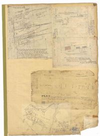
Page 13 of the City Engineer's Plat Book with five plats. Plat 1 features plots on East Bay Street between Tradd Street and Broad Street (which is labelled in the top-left corner), including several wharfs. Plat 2 shows lots located between Archdale Street and King Street, including a plot belonging to the "German Lutheran Church." Plat 3 features a plot of land located on King Street. Plat 4 shows plots located on State Street between Market Street and Amen Street. Plat 5 features "Potters Field Public Cemetery," located near President Street and Congress Street.
Page 7 of the City Engineer's Plat Book with four plats. Plat 1 shows lots on Bay Street. Plat 2 features plots on Hanover Street near the intersection with Reid Street and shows a lot labelled "African Burial Ground." Plat 3 features lots between Payne Street and Rutledge Street, near Fishburne Street and Market Street. Plat 4 shows lots and buildings near the intersection King Street and Broad Street. Plat 5 features lots on Cumberland Street.
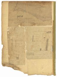
Page 5 of the City Engineer's Plat Book with three plats. Plat 1 shows plots near Meeting Street, Russell Street, King Street, and a creek labelled "Small Creek." Plat 2 shows plots of land near the intersection of Water Street and Church Street. Plat 3 shows Calhoun Street where it intersects with Ashley Street and Lynch Street, and shows a lot labeled "St. Xavier's Infirmary."
Page 6 of the City Engineer's Plat Book with three plats. Plat 1 shows a lot on the Ashley River. Plat 2 shows lots on Friend Street located between Broad Street and Tradd Street. Plat 3 features lots on King Street and includes a lot labeled "Orphan House Lot."
Page 12 of the City Engineer's Plat Book with two plats. Plat 1 shows plots near Coming Street, St. Phillip Street, King Street, Meeting Street, and Vanderhorst Street. Plat 2 Shows lots on Queen Street near the intersections with East Bay Street and Prioleau Street, has the label "Charleston Harbour Cooper River" on the right-hand margin.
Page 9 of the City Engineer's Plat Book with four plats. Plat 1 shows lots near the intersection of Cannon Street and Smith Street. Plat 2 features plots of land and buildings located near Savage Street. Plat 3 shows plots of land located near the intersection of Queen Street and Rutledge Street. Plat 4 features lots on Simons Street.
Page 8 of the City Engineer's Plat Book with two plats. Plat 1 shows plots near "Village Hampstead Public Square" and shows numerous streets including King Street, Columbus Street, and Meeting Street. Plat 2 shows lots near the intersection of Radcliffe Street and King Street, including a lot labelled "Estate of McIntosh."
Page 10 of the City Engineer's Plat Book with two plats. Plat 1 shows plots located near Pointset Street and Grove Street between King Street and Russell Street. Plat 2 shows plots near Judith Street and Chapel Street, and includes "Beaufort's Court" and "Heyward's Court."
Page 2 of the City Engineer's Plat Book with five plats. Plat 1 shows the intersections of Guignard Street with East Bay Street and "Raper's Alley," and features a building labelled "Old Mansion Ruins." Plat 2 shows the intersection of East Bay Street and Market Street near the "Charleston Harbour on the Cooper River," and features plans to expand Market Street. Plat 3 features a stretch of land from the end of Rose Alley to the Cooper River, labelled as "Union Warf No. 1." Plat 4 features the same stretch of land as Plat 2 with slightly more land to the north. Plat 5 features the intersections of Tradd Street with Legare Street and Friend Street.
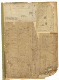
Page 4 of the City Engineer's Plat Book with seven plats. Plat 1 features East Bay Street, Pinckney Street, Concord Street, and lots labelled "Burnt District." Plat 2 features lots on King Street. Plat 3 shows several lots on East Bay Street near the intersections with Pritchard Street and Hard Alley. Plat 4 shows three lots on East Bay Street. Plat 5 features lots at the intersection of East Bay Street and Hasell Street. Plat 5 shows a stretch of Queen Street including the intersections with Archdale Street and Friend Street, and includes a plat labelled "Catholic Church." Plat 7 shows plots of land on the intersection of Tradd Street and Meeting Street.