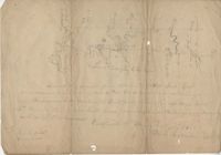
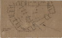
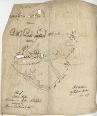
Plat contains 360 acres. Plat includes sketch of house. Names associated with this plat include John Glen, Ephraim Mitchell, Crip, Daniel Cannon, and John Richards. Notable geographic locations include St. James Parish, Goose Creek and Charleston District.
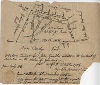
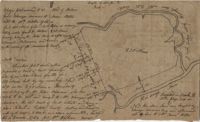
Plat contains 310 acres layer out for John Gamble granted November 6, 1706. Plat contains location of house. Names associated with this plat are John Gamble, Gideon Fishero, Amos Donoly, John Deas, Francis Cobia, Purull, and F. Bremar.
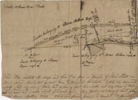
Plat of 1,000 acres on Strawberry Bay granted to James Packer. The bay and marsh area is marked but there is little other detail included. Names associated with this plat include James Packer, William Sparkmon, James G. Ware, and W. Moultrie.
Plat of 163 acres in the St. George District. Very little detail or explanation provided on the plat. Names associated with this plat are David Run, John Woodrich, Elibu [?] Baker, John Drayton, and B. Wood [?]. Notable geographic locations include St. George Parish and St. George District.
Plat of land with rice fields and highlands noted along with the neighboring properties. Very little other detail or explanation given. Names associated with this plat include Carson, Isaac Waight, and Ann Stanyarn.
Plan of 500 acres of land along Turtle Island. Notable geographic locations include St. Peters Parish, Turtle Island, Wrights River, Dawfuskie [Daufuskie] Sound, Black Oyster Point, and New River.
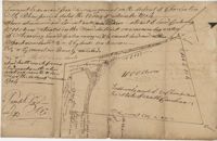
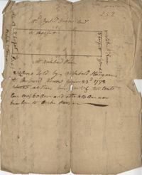
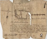
"Release from Thomas Osborn a Sheriff Charleston District to Philip Hart dated 6 October 1794 for a tract of land measuring and Containing 500 acres more or less situated lying and being on the Cypress Swamp in the district of Charleston Butting and Bounding Westwardly on land now or late the property of David Manll. Southwardly on lands of John Conard, Eastwardly on lands of Thomas Waring and Northeastwardly on lands belonging to Major James Postell - Sold under [?] in the property of William Doweth." Names associated with this plat are Thomas Osborn, William Dewitt, Hart, David Manll, John Conrad, Thomas Waring, Philip Hart, James Postell, and William Doweth. Notable geographic locations include St. George Parish, Cypress Swamp and Charleston District.
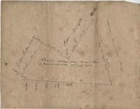
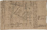
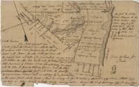
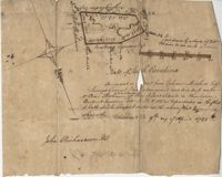
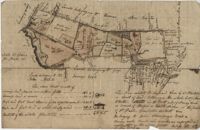
"In the above delineated plat A represents a tract of land containing 120 acres originally granted to William Sanders the 10 May 1734 for 100 acres, now held by William Allen Milis B containing 134 acres is part of a tract granted to Roger Simner the 21st day of April 1733 for 4200 acres and now held by William Edward Perry - Situated on the Cypress Swamp in St. George’s Parish Berkeley County and… a fore said and butting and bounding and having such marks and shape as are about set the Certified the 23rd July 1775 by John Fenwick Copy taken from the original in July 1801." Names associated with this plat are William Allen Milis, Roger Simner, William Edward Perry, William Benjamin Coachman, William John Glaize, Daniel Blake, William H. Drayton, Watter, Sanders, and John Fenwick. Notable geographic locations include St. George's Parish, Cypress Swamp, and Bedons.
Plat of 230 acres on Johns Island. Little detail included on the plat, but there is an short explanation of the deed. Names associated with this plat are John Jones, Ebenezer Simmons, James Witter, Samuel Palmevine, John Palmavin, and Welkins. Notable geographic locations included in this plat are the Keiwaugh [Kiawah] River, Coll’s Creek, Savannah Tract, Johns Island, and Colleton County.
Plan of a parcel of land situated on Johns Island and containing 86 1/2 acres. Being part of a body of land belonging to Thomas Mathews. Bounded northwardly by a public road, eastwardly on James Legare's land, and southwardly on land belonging to Isaac Holmes and Thomas Legare. Intended to be conveyed to Isaac Holmes. Names associated with this plat are Thomas Mathews, Isaac Holmes, Thomas Legare, William Stanyarn, Matthews and James Legare.
Two plats of lands along the Savannah River belonging to Stobo and Bullock. Names associated with this plat are Archibald Stobo, James Stobo, James Bullock, W. Hugh Bryan, Clawton [?], Cranford, J. Southerland, and Patrick Mikas. Notable geographic locations include the Savannah River, St. Peter's Parish and Purrysburgh Township.
222 acres sold by Archibald Stanyarn to Andrew Down in 1772. Reverse side includes notes on various conveyances. Names associated with this plat are Archibald Stanyarn, Andrew Down, J. Williamson, Edmond Bellizer, Thomas Cliffon, Kewn [?], David Joomer [?] and Henry. Notable geographic locations include Colleton County and Stono River.
Copy of a plat part now belonging to Benjamin Perry and part to John Pringle on the west side of Ashley River. Names associated with this plat include John Pringle, Benjamin Perry, John Julius Pringle, Lambert Lance, Abraham Ladson, Sarah Rose, Nathaniel Bradwell, Ephraim Mitchell, Thomas Drayton, John Frazer, Frances Baker, Thomas Osborn, Isaac Landson, Isaac Perry, John Drayton, Glen Drayton, Francis Ladson and W. John Cattle. Notable geographic locations include the Ashley River, Charleston, Berkeley County, and Ashley River Road.
Plat and abstracts of deeds belonging to James Laurence. Names associated with this plat include James Laurence, John Heyward, John Cole, Hogg, Loalan, Samuel Forsythe, William Forsythe, J. Schreiber, Henry Laurence, Harrison, Alexander Wright, Horry [?], and John Delayay.
Plat of 1000 acres on the Scull Creek belonging to John Luck. Details include the areas of the creek and minimal buildings. Names associated with this plat are John Luck and J.B. Gerardeau. Notable geographic locations include Hilton Head Island, Cotton Hope Plantation, Fairlawn, St. Luke's Parish and Scull Creek.
Plan of Cotton Hope Plantation on Hilton Head Island with no acreage included. Details include a marsh, swamp, and surrounding lands. Names associated with this plat are Hugh McDowel, William Horton, and Thomas Rorksdale.
Plat of 101.5 acres on Ocketee [Oakatie] Creek. Plat shows the location of a marsh, road and surrounding lands. Names associated with this plat are N.H. Johnson, Ellis and Hogg. Notable geographic locations include the Savannah River, Oakatie Creek and Ellis Road.
Plat of 200 acres above Bacon Bridge surveyed for William Drayton. Details include the property lines, trees, the location of the swamp, a field, a canal and roads. Names associated with this plat are Joseph Coachman, William Drayton, Thomas, Thomas Smith, J.J. Keersy [?], Chandless, Gales, and J.H. Waring. Notable geographic locations include Mary Creek Swamp [?], Broad Road, and Bacon Bridge.
Plat of 380 acres on a great swamp near Coll. Pen Bay. Names associated with this plat are John Jones, Joseph Haynes, Lewis Oglesbee, M. Cattersloni [?], and John Rofe.
Plat of 1199 acres in St. Johns Parish. Names associated with this plat are Daniel Gelyer, Peter Sanders, James Rown, Thompson, Meadwell, S. Brichelle [?] and Maun. Notable geographic locations include Berkeley.
Plat of 1199 acres of land in St. John’s Parish; little geographical information. Names associated with this plat are Robert Daniel, Brichell, Treadwell, William Maime [?], James Rown, John Frierson, and Peter Sanders.
Plat contains 500 acres on the Edisto River. Names associated with this plat are William John Gerardeau, John Stock, William Livingston, Thomas Broughtors, Charles Craven, Charles Parker. Notable geographic locations include South Edisto River and Colleton County.
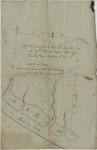
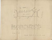
"350 acres granted to Thomas Smith on the 28th March 1694, Bounding [?] On Medway River South on land formerly laid out to Robert Skelton and went north…" Names associated with this plat are Thomas Smith and Robert Skelton.
120 acre plot purchased by George Rivers, shows Bohicket Creek and several smaller creeks, also denotes some marsh, highland, and riverbanks, the plot of land is divided into six smaller plots with "Broad Road" running between them. Names associated with this plat are John Rivers, Dr. Micah Jenkins, James Stanyon, George Rivers, Hearn, Matthews, Solomon Freer, William Spencer, James Rivers, John Taylor, Margaret Simpson, William Holmes, John Holmes and James Legare. Notable geographic locations are Bohicket Creek, Johns Island, and Colleton County.
"Pursuant to a Warrant for, [?] Mitchell Esquire Surveyor General Sha [?] Ad measured and laid out unto William Peter Reahimer a tract of land containing 136 acres situated in Charleston District, bounding SW on land belonging to Thomas Broughton Esquire South on land belonging to William Singleton [?] on Mr. John Ansil and has such shape and mark as the above plat represents Surveyed 9th day of April 1785." Includes two water sources dividing the property. Names associated with this plat are William Peter Redhimer, Thomas Broughton, William Singleton, John William Ansil, and John Richardson.
Persuant to [?] from Ephraim Mitchell Esquire Surveyor General that admeasured and laid out un to William Peter Redhimer a tract of land containing 97 acres of land situated in Charleston District bounding NW [?] as represented in the plat and hath such shape and marks as the above plat Surveyed this 9th day of April 1785. Names associated with this plat are William Peter Redhimer, John Richardson, Colonel Isaac Motte, Thomas Singleton, Reating Simoner, Ephraim Mitchell and Keating Simone.
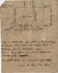
"Plan of a Plantation containing 240 acres in St. Andrew’s parish belonging to William Newbenny. Surveyed by N. Brandwill March 1772. Copy taken from the plan in the property of William Newbenny." The plat also contains the location of a structure and a road leading to it. Plantation located on East side of Ashley River. Names associated with this plat are William Mewhening, N. Brandwill, Whitenarth Tuller, William Scotts, Ralph Izard, the Lords Proprietors, William Williams and William Scott.
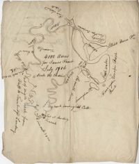
4000 acre plot of land for James Peach with its natural boundaries being rivers instead of property lines, also shows surrounding properties and their names. Names associated with this plat are James Peach, Lowright and Ellis Barce. Notable geographic locations include New River, Wrights River, Daufuskie Island, New River, Wright’s River, The North River, Cuningham Point, Savannah River, Black Oyster Bank, Turrapin Beech, Pine Island Creek, Red Bluff, and Townbridge Landing.
Plat includes 272 Acres with the Broad Road bisecting the property. Names associated with this plat are William Perry Perry, N. Bradwell, Archer Smith, the Ministry Lands and Joseph Perry. Notable geographic locations include St. George’s Parish, Bach Hill, Dorchester, and Broad Road.
Plat of 1000 acres is surrounded by vacant land. Names associated with this plat are John Stuart. Notable geographic locations include Berkeley County and St. Stephen's Parish.
Plat of 202 acres in St. James Goose Creek belonging to James Headright. Details include trees on the property line and the names of neighboring property owners. Names associated with this plat are James Headright.
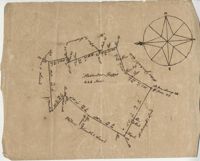
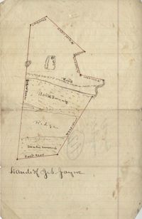
Unnamed plot of land that is divided into four parts, Santee swamp, ridge, Buck Swamp, and the section that includes a road and the house, no measurements or surrounding details. Names associated with this plat are G.S. Jayne.
Copy of two tracts of land A and B. A containing 1144 acres, and B, containing 580 located north of the Santee River and Duck Creek for Georgetown District. John Hutchinson, Chardon, Laroche, Foijsin, Gail Huger, Isaac Huger, Mark Hugin, Ford, Job. Rothmaklen, Jospeh Purcell and Charles Parker. Notable geographic locations include Mosquito Creek, Four Mile Creek, Belin Creek Duck Creek, Minim Creek, Santee River, Winyaw Bay, and Georgetown District.
296 acres of land conveyed to Alexander Walker to John Sumer and M. Weston executors of the last will and testament of Richard Downs (1705). Names associated with this plat include Richard Downs, Smith, Joseph Stanyarn, Coats, Alexander Walker, John Sumer, Plowden Weston, Roper and Chrisby [?]. Notable geographic locations include Broad Road to Jacksonborough and Stono.
56 acre plot of land given to Radcliffe, the plot of land is bordering Cuckolds Creek, shows surrounding property owners, no land type detail or identification. Names associated with this plat are Thomas Radcliffe, Nathaniel Heyward, John Goddard and James Heyward. Notable geographic locations include Cuckolds Creek, Combahee River and St. Bartholomew's Parish.
179 acre plot of land given to Mr. Webster, shows the property lines and no land type detail. Names associated with this plat include Webster, Peters, Branford, and John James Haig. Notable geographic locations include the Pon Pon River.
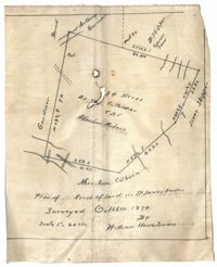
Plan of land in St. James Santee for Abraham Micheau. Names associated with this plat are Ann Colburn, Gardner, Anthony Germain, Buneli, B. Skipper, Isaac Skipper, Abraham Micheau, and William H. Simons.
Copy of plat of land being 903 belonging to Archer Smith in Georgetown District on the side of Pee Dee. Names associated with this plat are Archer Smith, Thomas Water, Abraham Livingston, J. Roshnakler, W. Glover, Preugh [?], Thomas Skrine [?], John J. Pringle, Alexander Roses and John Coates. Notable geographic locations include Pee Dee, Georgetown District, and Path to Black River from Pee Dee.
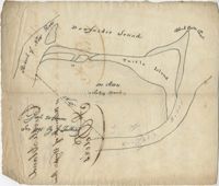
Plat of land with unknown acreage on Wadmalaw Island. Names associated with this plat include Gibbs, Wescot, and Benjamin Walter. Notable geographic locations include St. John's Parish, Wadmalaw Island, Colleton, and Public Road to Beau Bluff.
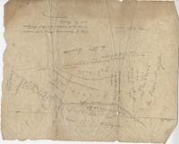
Plat of land near Pocotaligo. Very little information and explanation are included. The land looks to be near a crossroads and some form of water. Names associated with this plat are Cuthbert. Notable geographic locations include Augusta Road, Cossawhatchie [Coosawatchie], Pocotaligo, and Prince William's Parish.
Plat contains 1000 acres. Names associated with this plat include William Liott and David Celiphairch [?]. Notable geographic locations include St. George Parish.
58 acres of land laid out unto M. Belin situated on Sandy Island. Names associated with this plat are John Hardwick, Thomas Waring, Broughton and Postell.
Plat of land of 64 acres laid out for Allard Belin situated on Sandy Island. Names associated with this plat are Allard Berlin, John Hardwick and D.T. Waring.
"A Plan of a Plantation or Tract of Land on Penny Creek a Branch of Ponpon or Edisto River late the property of Joseph Bee Esquire now belonging to John Champney Esquire." Plat contains 687 acres on the north side of Penny Creek the plat is divided by use of lands and the location of structures on the property. Names associated with this plat are John Champney, Dr. John Mitchell, Thomas Bee, Joseph Bee, and George Savage. Notable geographic locations include Penny Creek, Edisto River, Pon Pon River, Landing Road, and Bridge Road.
Limit your search
John McCrady Plats and Deeds Collection✖[remove]246