True copy of Peter Sinkler plat contains 310 acres in Craven County [now in parts of Berkeley, Charleston, Georgetown, and Williamsburg counties] bounding northwest on land of Isaac Porcher and Rene Pyre, southeast on land of Robert Taylor and Rene Ravenel, and northwest on Santee River. Names associated with this plat are Peter Sinkler, Robert Taylor, Ephraim Mitchell, Rene Pyre, Isaac Porcher, Rene Ravenel, John Brernon, and Henry Mowlon. Notable geographic locations include St. James Parish, the Santee River and Craven County.
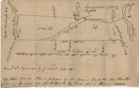
Copy of a plan of 195 acres of land near the Cooper River including dams, a house, marsh and saw pit. Names associated with this plat include Mary Rupell, Robertson, Atkin, Dr. Brabangs, Withers, Jenson, Lanue and G. Arch.
Plan of a tract of 1000 acres of land in Wall Eye Swamp in Craven County [now in parts of Berkeley, Charleston, Georgetown, and Williamsburg counties]. Names associated with this plat are Samuel Cooper, James Sinkler, Peter Sinkler, Isham Moore, John Bremar, and William Bull.
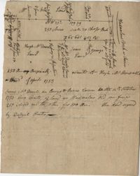
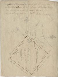
Plat of 250 acres on Wadmalaw Creek. Includes short explanation, but plat itself includes very little details. Names associated with this plat are Hugh McDowel, James McDowel, James Carson, Dalziel Hunter, James Young and Ellis.
Plat includes 624 acres surveyed for Gideon DuPont. Plat does not contain structures. Names associated with this plat are Gideon DuPont, William Thomas Elliot, Captain Daniel Godin, and Middleton. Notable geographic locations are St. Bartholomew's Parish, the Ashepoo River and Deer Creek.
Plat of 500 acres granted to Robert Cahousac January 10,1771. Names associated with this plat are Robert Cahousac, Samuel Cooper, Gabriel Gigneliat [?], Mitchum, Witten, Zachariah Villeponteux, William Mazyck, Juxbury Lumber Co, William Washington, and Charles Parker. Notable geographic locations include St. Bartholomew's Parish and Charleston County.
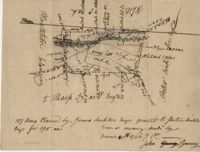
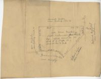
Plat of 300 acres in Berkeley County. Very little detail included in the plat. Names associated with this plat are James McKelvey, John Evans and Sarah Vance. Notable geographic locations include Berkeley County and Russells Creek.
Copy of two plats: 1) 300 acres conveyed by Thomas Lynch to William Moultrie April 1, 1762, afterwards conveyed by Moultrie to Benjamin Singleton 2) 53 acres conveyed by Francis Kinloch to William Moultrie on the 8th February, 1765 now belonging to Benjamin Singleton. Names associated with this plat are Thomas Lynch, William Moultrie, Benjamin Singleton, Francis Kinloch, and Manigault. Notable geographic locations include Santee, White Oak, Six Mile Creek, and the Santee River.
222 acres sold by Archibald Stanyarn to Andrew Down in 1772. Reverse side includes notes on various conveyances. Names associated with this plat are Archibald Stanyarn, Andrew Down, J. Williamson, Edmond Bellizer, Thomas Cliffon, Kewn [?], David Joomer [?] and Henry. Notable geographic locations include Colleton County and Stono River.
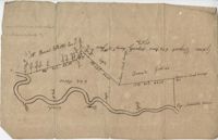
400 acres of land once owned by James Wrixon, then Purchas Morgan, and then Henry Webster who conveyed the land to Ezekiel Branford and Christopher Peters. 250 acres came to the ownership of Ezekiel Branford (N1 and N2) and the remaining 150 acres owned by Christopher Peters (N3). The dates of purchase can be found on the plat. The lands contain pine, gum, cypress, white oak and hickory trees. The lands lie to the east of the Ponpon River. Names associated with this plat include Henry Webster, James Wrixon, Ezekiel Branford, Christopher Peters, Purchas Morgan and Alexander Watkin.