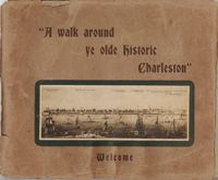
Souvenir booklet for guests of the Charleston Hotel, produced after the hotel's renovation and when it was under the new management of Francis G. Cart and W. Irving Davids. Includes a description of the hotel and its remodeling, along with a brief history of Charleston and photographs of points of interest. [16] p., ill., 11x15 cm. (Note: The Charleston Hotel was located on the 200 block of the east side of Meeting Street. It was demolished in 1960.)
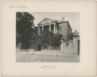
The folio, Examples of Colonial Architecture in Charleston, S.C. and Savannah, Ga., features photographic plates of some of the most important houses and buildings in Charleston and Savannah. Photographs include exterior views of the buildings, gates, and entrances, as well as interior views of fireplaces, mantels, doors, rooms, and ceilings. Compiled and photographed by Edward A. Crane and E.E. Soderholtz. Published in 1895 by the Boston Architectural Club (Boston, Mass.).
Photographs taken by Sabina Elliott Wells in 1898-1899. Wells was a Charleston artist and designer; she was also a Newcomb potter. Photographs include scenes in Charleston and the Lowcountry, in northwest South Carolina (Table Rock and vicinity), and in western North Carolina (Flat Rock and vicinity). Scans were derived from negatives donated to Historic Charleston Foundation. (Note: Wells's diaries from 1898-1899 that document some of her travels, including sites represented in these photographs, are at the South Carolina Historical Society, "Sabina E. Wells papers, 1886-1942.")
Guide for a walking tour of Charleston, containing a brief history of Charleston; descriptions of each location on the tour; and photographs of notable buildings. Published by Lanneau's Art Store (Charleston, S.C.). [6] p., [24] leaves : ill. ; 27 x 32 cm.
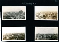
Four aerial views of Charleston looking across the peninsula. Top left: Looking northeast, possibly from St. Michael’s Church, showing Broad Street and the area to its north bounded by East Bay Street, and possibly Queen Street. Cars are parked along the street. Landmarks include the Confederate Home and its rear dormitory apartments, People's Building, Old Exchange Building, and the corner of Broad and Church Streets showing the Bank of South Carolina Building (50 Broad Street) before it was restored. A faint view of the U.S. Customhouse is at the far left. Top right: Looking southeast, possibly from the Francis Marion Hotel, with Meeting Street bisecting the view at a diagonal. Landmarks include the U.S. Customhouse, Charleston Hotel, People’s Building, and St. Philip’s Church. Bottom left: Looking south on King Street, possibly from the Francis Marion Hotel, showing King Street from approximately 360 King down to the bend near Market Street, and the view east of King Street. Vehicles can be seen on King Street. Landmarks include the Masonic Temple Building (270 King Street), the tower of the Peoples First National Bank Building (also known as the Hirsh Israel Building, 275 King Street), and the Hotel Calhoun (238-242 King Street). Bottom right: Looking southwest, possibly from St. Michael’s Church, toward James Island. Landmarks include the Fort Sumter House (1 King Street), Col. John Ashe House (32 South Battery), rear of First Scots Presbyterian Church (57 Meeting Street), Miles Brewton House (27 King Street), and the north elevation of the John E. Poyas House (69 Meeting Street).
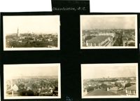
Four aerial views of Charleston looking across the peninsula. Top left: Looking northeast, possibly from City Hall. Landmarks include the rear dormitory apartments of the Confederate Home, St. Philip's Church, and the U.S. Customhouse. Top right: Looking north on Meeting Street, possibly from St. Michael’s Church, and showing the view west of Meeting Street. Vehicles, including a trolley car, can be seen on the street. Landmarks include the Timrod Hotel, Mills House Hotel, Fireproof Building, Circular Church, and Francis Marion Hotel (in the distance). Bottom left: Looking east on Calhoun Street, possibly from the Francis Marion Hotel, and showing the view east and west of Calhoun Street. Vehicles can be seen on the street. Landmarks include the Calhoun Monument in Marion Square, Citadel Square Baptist Church, and Emanuel A.M.E. Church. Bottom right: Looking north possibly from St. Michael’s Church. Landmarks include St. John's Lutheran Church, Unitarian Church, Grace Episcopal Church, and the Charleston Orphan House (in the distance at right).
This collection of gelatin silver photographs by Kenneth Clark consists of the original prints that were reproduced in three issues of the White Pine Series of Architectural Monographs, published by Russell F. Whitehead. The series was intended to provide 'intimate treatises of the architecture of the American colonies of the early Republic presented with well ordered completeness, to further a broader understanding and to create a permanent record of Early American architecture.'
In 1928, five issues highlighted Charleston architecture. The photographs feature Charleston buildings, street scenes, views, and architectural details. They appeared in three of the five Charleston issues: 'The Charm of Charleston: A New World City of Old World Memories' (vol. XIV, no. 2), 'Some Charleston Mansions' (vol. XIV, no. 4), and 'The Edwards-Smyth House' (vol. XIV, no.6).
A brief introduction about the atmosphere and architecture of Charleston precedes photographs of Charleston buildings, streets, and views. Also features a "Portfolio of Picturesque Charleston Sketches," pencil drawings by Alfred Hutty. Edited and published by Russell F. Whitehead (New York, ??1928). Photographs by Kenneth Clark. Measured drawings (measured and drawn by Kenneth Clark) from the George F. Lindsay Collection of Early American Documents. Also includes promotional essay entitled "Innovations in Manufacture and Distribution of Lumber: Weyerhaeuser 4-Square-Package Method'; wood construction details; and corporation information about Weyerhaeuser Forest Products (St. Paul, Minnesota). Volume 14, number 2, of The White Pine Series of Architectural Monographs. Twenty-two pages; page numbering of original begins at 171.
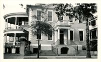
History and architectural description of the William Gibbes House [64 South Battery] by Roy Marvin, illustrated with photographs and measured drawings. Edited and published by Russell F. Whitehead (New York, ??1928). Photographs by Kenneth Clark. Measured drawings (measured and drawn by Kenneth Clark) from the George F. Lindsay Collection of Early American Documents. Also includes wood construction details and corporation information about Weyerhaeuser Forest Products (St. Paul, Minnesota). Volume 14, number 3, of The White Pine Series of Architectural Monographs. Twenty-two pages; page numbering of original begins at 195.
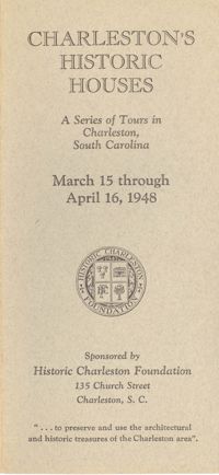
Single brochure for the 1948 Historic Charleston Foundation's Tour of Homes and 27 corresponding pamphlets about each individual home. These pamphlets contain descriptions by Samuel Gaillard Stoney (with illustrations) of each house on tour in 1948. Produced by Historic Charleston Foundation, 1948.
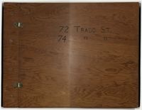
Compilation of original deeds, titles, and other documents related to the transfer, sale, and ownership of the double tenement at 72-74 Tradd Street, known as the Fotheringham-McNeil Tenements. Documents span from 1765 to 1961, likely representing the entire history of the ownership of the double tenement throughout that time period. Also includes blueprints and photographs. (NOTE: Fotheringham has also been spelled Fotheringham.)
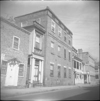
Looking east on Wentworth Street from 26 Wentworth Street (Gardner Kitchen House). Features (left to right): 26 Wentworth Street, 22-24 Wentworth Street (Francis Q. McHugh Tenements), 18-20 Wentworth Street, and 14 Wentworth Street.